Showing 22200 items
matching parks
-
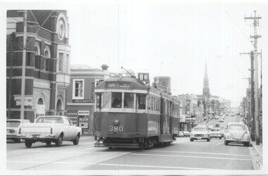 Melbourne Tram Museum
Photograph - Set of 4 Black & White Photograph/s, Clive Gibson?, c1975
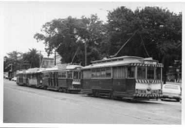
Set of four Black and White photographs of W2 380. Photos not dated, c1975. .1 - Toorak Road, just past Osborne St, South Yarra, with the South Yarra Post Office in the view. Also Helmuts Milk Bar? Tram has the destination of Chapel St, route 8B. .2 - Turning from Park St South Yarra into Toorak Road. Tram has the destination of Toorak, route 8. Note the Bundy clock on the left hand pole. .3 - In St Kilda Road, at the Arts Centre, with destination of Elsternwick, Route 4E. .4 - turning from Toorak Road into Park St, route 8. See image i5 for envelope which has the names of Clive Gibson, Dave Menzies and date 1975 which could be the date the photos were sent to Dave Menzies for some reason.trams, tramways, w2 class, bundy clock, route 8b, toorak road, south yarra, park st, route 8, st kilda rd, route 4e, elsternwick, tram 380 -
 The Beechworth Burke Museum
Photograph, c. 1905
Taken in c. 1905, depicted is a large group of children and adults dressed in formal attire sitting and standing upon a granite rock that is located in the centre of Queen Victoria Park. In front of the group is a wooden picket wire fence that sides the granite rock. On top of the rock is a gas lamp post.Originally known as the Beechworth Botanical Gardens, the Queen Victoria Park features a extensive collection of historic trees and plants, which have been listed on the Indigo Shire’s Significant Tree Register.Black and white rectangular reproduced photograph printed on matte photographic paperReverse: 6956 (in pencil)/ ©/ DONALD HAYES/ BEECHWORTH (stamped in orange ink)/entertainment album, burke museum, beechworth, queen victoria park, park -
 Greensborough Historical Society
Newspaper Clipping (copy), Greensborough. 2 Dec 1927, 02/12/1927
Article describing new utilities in the Greensborough district: continuous telephone service; letter and telegram delivery within a half-mile radius of the post office; new water system to supply Grace Park, and plans to supply water to the Greenhills Estate, and comments on the train service from Heidelberg to Eltham.2 p. typescript (OCR transcript of original article, copied from Trove)water supply, postal services, railways, greenhills, grace park, telephone service, greensborough -
 Greensborough Historical Society
Article - Website, National Trust of Australia (Victoria), Mont Park: Statement written by National Trust of Australia (Victoria), 17/09/2010
Statement of Cultural heritage Significance for Mont Park acquired by Victorian state government in 1909 and used as a mental hospital complex comprising Larundel Kingsbury and Greswell facilities, finally decommissioned in1969. Contains extensive descriptions of regionally significant indigenous and exotic vegetation, landscaped by designer Hugh Linaker.2p. typescriptmont park, larundel, gresswell, hugh linaker -
 Eltham District Historical Society Inc
Newsletter, Newsletter, No. 31 July 1983
Contents: • Next meeting guest speaker, Jack McLean: The Hurstbridge Line; a brief history • Falkiner Cottage, Ely Street, Eltham • Subscriptions • Hurstbridge Bank Building • St Andrews School – 125th Anniversary • Kinglake National Park • New Committee member • “Donald Thomson in Arnhem Land” The Shire of Eltham Historical Society was formed in October 1967. The first newsletter of the Society was issued May 1978 and has been published continuously ever since on a bi-monthly basis. With the cessation of the Shire of Eltham in late 1994, the Society's name was revised to Eltham District Historical Society and this name first appeared with issue No. 103, July 1995. The collection of the Society's newsletters provides a valuable resource on the history of the Society's activities, office bearers and committee members, guest speakers and subjects of historical interest pertinent to the former Shire of Eltham and the Eltham District.A4 photocopied newsletter distributed to membersnewsletter, eltham district historical society, shire of eltham historical society -
 Emerald Museum & Nobelius Heritage Park
Book, Friends of Kirth Kiln, Fireside Stories, The Parkers as Friends of Kurth Kiln, February 2010
Kith Kiln was the site of a short lived charcoal kiln designed to provide an alternative to petrol during World War 11 when there was a fuel shortage. Local history has been told by Genseric (Bill) Parker and the reflections collected by Friends of Kirth Kiln (under the auspices of Parks Victoria).The booklet is significant because it tells the story of the development of the Kirth Kiln Park in Gembrook, from the Friends perspective.The park is not only historical but is also of great environmental significance and it forms part of community life in the district. Green soft cover booklet of 128 pages. The front cover has 2 photos; the top one of the caretakers compound with Forest Commission huts and the bottom photo is of the Lake, taken from the dam on Tomahawk Creek. The back cover has a diagram of the Kiln logo.Fireside Stories with Genseric (Bill) Parker and Lorna Parker. Reflections collected by Friends of Kirth Kiln.kirth kiln, genseric parker, parks victoria, gembrook, charcoal burner -
 Eltham District Historical Society Inc
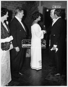
Photograph, Shire of Eltham Centenary Dinner, 6 Apr 1971
Shire of Eltham Centenary Dinner; Receiving Line. Left to Right: Mrs. J. White, Mr. E.O. Pelling, Cr. Mrs. Charis M. Pelling, Sir Rohan Delacombe, Cr. G.C. Dreverman. The event was held in the West Riding Hall, Petrie Park Community Centre, Montmorency. This photo forms part of a collection of photographs gathered by the Shire of Eltham for their centenary project book, "Pioneers and Painters: 100 years of the Shire of Eltham" by Alan Marshall (1971). The collection of over 500 images is held in partnership between Eltham District Historical Society and Yarra Plenty Regional Library (Eltham Library) and is now formally known as 'The Shire of Eltham Pioneers Photograph Collection.' It is significant in being the first community sourced collection representing the places and people of the Shire's first one hundred years.Digital imagesepp, shire of eltham pioneers photograph collection, shire of eltham, shire of eltham centenary, official dinner, sir rohan delacombe, cr. g.c. dreverman, centenary celebrations, mrs. j. white, e.o. pelling, cr. mrs. c.m. pelling, charis pelling, petrie park community centre montmorency -
 Orbost & District Historical Society
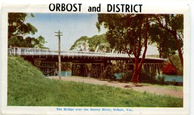
postcard series, 1960s
Included are photographs of the Orbost township, the Snowy River at Marlo, Gypsy Point, Buchan Caves and Bairnsdale. In the 1960s Orbost had a population of 4000 and was a major tourist attraction in Eastern Victoria with sufficient accommodation and facilities. It was the major town close to several national parks with access to either the surf or the snow. These postcards are pictorial records of Orbost in the 1960s. Postcards are very interesting records of places. architecture and transport.A colour postcard series with photographs of Orbost and the district. The cover photograph is of the Snowy River Bridge. There is an information card.Each photograph is labelled. at the bottom.postcards-orbost postcards-east-gippsland -
 Cheese World Museum
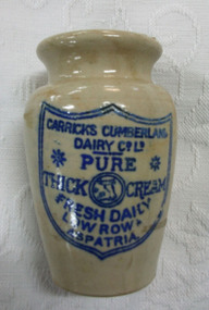
Jar, Pottery cream jar
The Percy Uebergang family lived at Tooram Park, Allansford from 1912 until 1992. The cream jar was part of the collection of items given into the care of the Cheese World Museum. Uebergang catalogue No.O 30 Carrick's Cumberland Dairy is a UK firm located at Low Row near Brampton.Small urn-shaped stoneware cream jar with blue shield-shaped label printed on the front, featuring a logo of a cow's head in a circle with double line around it.CARRICKS CUMBERLAND/ DAIRY CO LTD/PURE/THICK CREAM/ FRESH DAILY/ LOW ROW/ ASPATRIAdairying, domestic items, food storage & preservation, rural industry agriculture, allansford, uebergang, bottles, food technology, jars, carricks cumberland dairy co ltd, cream food storage, stoneware -
 City of Ballarat
Artwork, other - Public Artwork, Col Henry, Spirit of the Forest by Col Henry, 2018
The artwork sought inspiration by the local history of Wendouree West and is a feature at the Wendouree West Recreation Reserve commissioned as part of a redevelopment of the park in 2017-2018. The artwork is located within close proximity to new playground facilities and promotes positive stories about Wendouree West to locals and the wider community.The artwork is of aesthetic significance to the people of BallaratThree stainless steel sculptures of Kurrajong tree leaves Col Henry 2018spirit of the forest, wendouree west, col henry, australian sculpture -
 Lake Bolac & District Historical Society
Black and white photograph, Mortlake Rd./Montgomery St., Lake Bolac, 1912
Mortlake Rd./Montgomery St., Lake Bolac, 1912. Looking northwards. Image shows the broad expanse of the grass verge and road (top left) with Josiah Park's forge and smithy, the pub and the store, with peppercorn trees planted along the street. On the right the public hall can be faintly seen.lake bolac, montgomery st., 1912. -
 Ballarat Tramway Museum
Photograph - Black and White - four trams in the City Loop, A T Miles, Nov. 1969
Black and White - four trams in the City Loop at the eastern end of Sturt St, including tram 33 and the Santa Tram. Trams were parked in the loop during the day between peak periods rather than run them back to the depot. Taken by A T Miles Nov. 1969.Yields information about the Ballarat Tramway operations and views during 1969.Photograph - black and white print with notes on rear.A T Miles stamp and location and date notes.tramways, trams, sturt st, city loop, tram 33, santa tram -
 Sunbury Family History and Heritage Society Inc.
Photograph, Werribee Open Range Zoo, c1989
The children from Bulla Primary School were on a school excursion to Werribee Park Mansion and Open Range Zoo when this photograph was taken. They spent the day taken into the mansion before moving onto the zoo where they saw a variety of exotic animals wandering freely in large fenced allotments.The excursion was part of the children's environmental studies. A non-digital coloured photograph of a group of children gathered outside a grand mansion. bulla primary school, werribee park open range zoo, werribee mansion -
 Warrnambool and District Historical Society Inc.
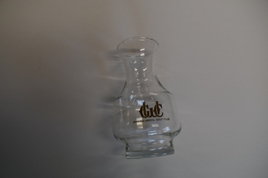
Souvenir - Warrnambool Golf Club Souvenir Carafe, late 20th century
This glass carafe has been produced for the Warrnambool Golf Club either to sell to raise funds for the club or to use as a competition trophy or to give to members and visitors on a particular occasion. The Warrnambool Golf Club, established in 1895 at Albert Park in Warrnambool, was re-located to Merrivale, Warrnambool in the late 1920s.This item is of some minor interest as a souvenir of the Warrnambool Golf Club, a prominent sporting body in Warrnambool.This is a clear glass wine carafe with a round base and body and a funnel neck with a circular opening at the top. One one side there is gold lettering, a small portion of which has rubbed off.WGC Warrnambool Golf Clubwarrnambool golf club -
 Ballarat Tramway Museum
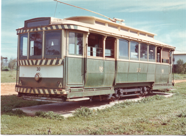
Photograph - Ballarat tram 30 - Kaniva, Bob Lilburn, 4-12-1973
Set of two colour prints of Ballarat tram 30 in a park at Kaniva. The tram was recovered by BTPS workers 6/7 July 1974. See Oct. 1974 issue of Trolley Wire) and Feb. 2014 issue of Fares Please! for the trams story. Photographer most likely Bob Lilburn.Yields information about SECV tram 30 at Kaniva.Set of two Colour prints - with photographers notes on the rear.In ink "4-12-73 No. 30" and "To Kaniva 10-2-72, BTPS 7-7-74"tramcars, tramways, tram 30, kaniva -
 Orbost & District Historical Society
black and white photographs, 1980s? (winter months)
All photographs seem to have been takenfrom the Telecom tower on the corner of Browning and Wolseley Streets in Orbost 3259.1 is a view of the Orbost township looking north-east. The swimming pool and bowling club can be seen in the foreground. 3259.2 is aview looking north-west and showing the tennis courts and clubhouse, the Recreation Reserve oval, the Youth Centre, Historical Museum, Municipal Offices, Senior Citizens clubrooms with the fire station in the foreground. 3259.3 is a view looking south with the Shire of Orbost Municipal offices and Ruskin Street in the foreground. Munro Street can be seen running from Ruskin Street to St Joseph's School in the middle distance. Lochiel Park oval, Lochiel House, the Snowy River and highway bridge are in the background. 3259.4 is a view looking south showing the Club Hotel, C.B.C. Bank in the middle distance and Hoffman's paddock (Forest Park) and the Snowy River beyond. 3259.5 is a view looking north-east over houses. 3259.6 is aview over the main street, Nicholson Street.showing the main shopping precinct. Shop signs for Permewans, Williams Shoes, F.B. Dicken and Orbost Bakery can be seen. 3259.7 is a view looking south west and shows Forest park and beyond towards Bete Bolong.These photographs are detailed pictorial records of the township of Orbost.Seven black / white photographs taken from above a township. Chimney smoke can be seen in the photographs.orbost-township-1980s aerial-photograph-orbost -
 Bayside Gallery - Bayside City Council Art & Heritage Collection
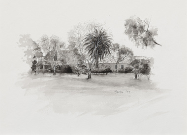
Work on paper - ink and watercolour, Annette Meikle, Semco Park, 1977
In 1977, artist Annette Meikle undertook a commission to illustrate a book recording stories of places and people in the Bayside area. It was published in 1978 as Sandringham Sketchbook, with text by Elizabeth Waters. The sketches were intended to record remaining examples of Bayside’s early architecture and environment, as well as reflect newer architectural changes. Meikle went on to donate 22 of these sketches to Bayside City Council in 2003. Semco Park was a model of exemplary modern business in the 1920s. Located on Cheltenham Road, Black Rock, then considered to be an outer suburb, the property was home to Semco, a manufacturing and importing business of paper goods and cotton fabric items. The business’s governing director, Charles Mylius, wanted a firm that treated staff with fairness, created healthy and spacious working sites and offered recreational facilities. The site contained a factory as well as three houses for staff, a park with lawns, trees and flowerbeds, a cricket oval and a canteen serving hot food. Staff enjoyed soft background music played in the factory, and benefited from a superannuation scheme. Semco Park was sold to developers in 1977 but the business continued until the early 1990s with the office moving to Mulgrave, while factory work shifted to New Zealand.Annette Meikle, Semco Park 1977, ink and watercolour, 25.8 x 35.7 cm. Bayside City Council Art and Heritage Collection. Donated by the artist, 2003annette meikle, sandringham sketchbook, elizabeth waters, semco park, semco, cheltenham road, black rock -
 Friends of Ballarat Botanical Gardens History Group
Slide - Colour transparency
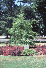
... parks ...Inscription on the plaque : "A tree that looks at God all day and lifts her leafy arms to pray." United States Marine Corps 1st Marine Division This tree is to commemorate the friendship established between the United States marines and the citizens of Ballaarat during their sojourn here in early 1943.View of the gardens with the sculpture of Wallace and the statuary pavilion.ballarat botanical gardens, trees, parks, lawns, flowers, pathways, plaque, memorial, united states, navy, marine corps, friendship, 1943, glove, anchor -
 Friends of Ballarat Botanical Gardens History Group
Slide - Colour transparency
... parks ...Inscription on the plaque : "A tree that looks at God all day and lifts her leafy arms to pray." United States Marine Corps 1st Marine Division This tree is to commemorate the friendship established between the United States marines and the citizens of Ballaarat during their sojourn here in early 1943.View of the gardens with the sculpture of Wallace and the statuary pavilion.ballarat botanical gardens, trees, parks, lawns, flowers, pathways, plaque, memorial, united states, navy, marine corps, friendship, 1943, glove, anchor -
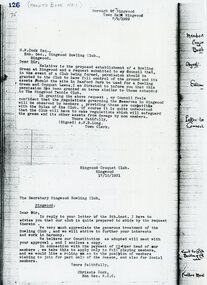 Ringwood and District Historical Society
Document, Ringwood Bowls Club- Letter from Town Clerk Ringwood relative to the establishment of a Bowling Green in Ringwood. Dated 7/9/1929
Typed letterLetter addressed to W.W.Cock Esq., Hon Sec Ringwood Bowling Club, giving permission for the Club to have full control of the ground and its assets should the site in Bamford Park be used for a Bowling Green and Croquet Lawns. Signed by A.F.B.Long, Town Clerk, Borough of Ringwood, 7/9/1929. -
 St Kilda Historical Society
Photograph, Georgia Dimitroulis, 2009
Colour photograph, mountedI enjoy my school being in Ripponlea because lots of people are caring. Ripponlea has very pretty houses too. Ripponlea also has really green parks which are really good to play in. Ripponlea is a great community to be in because nobody gets left out. By Georgia Dimitroulisbusinesses, glen eira road, ripponlea, ripponlea state school -
 Eltham District Historical Society Inc
Photograph - Digital Photograph, Marguerite Marshall, 'Landscape', 60 Lavender Park Road, Eltham South, 24 June 2008
Built by artist and cartoonist Percy Leason in 1927 in what was then New Street but renamed Lavender Park Road in the late 1950s/early 1960s. Covered under Heritage Overlay, Nillumbik Planning Scheme. Published: Nillumbik Now and Then / Marguerite Marshall 2008; photographs Alan King with Marguerite Marshall.; p121This collection of almost 130 photos about places and people within the Shire of Nillumbik, an urban and rural municipality in Melbourne's north, contributes to an understanding of the history of the Shire. Published in 2008 immediately prior to the Black Saturday bushfires of February 7, 2009, it documents sites that were impacted, and in some cases destroyed by the fires. It includes photographs taken especially for the publication, creating a unique time capsule representing the Shire in the early 21st century. It remains the most recent comprehenesive publication devoted to the Shire's history connecting local residents to the past. nillumbik now and then (marshall-king) collection, landscape, lavender park road, percy leason, new street -
 Eltham District Historical Society Inc
Album - Photograph, J.A. McDonald, Garden Hill, Kangaroo Ground, c. 1962
Garden Hill burnt following bush fires - most likely the 15-16 Jan 1962 fire A helicopter can be seen flying over the top of the hill Eltham Shire Council purchased this property in the early 1970s and it has now been incorpoarted within the Shire of Eltham Memorial ParkRecord of various Shire of Eltham infrastructure works undertaken during the period of 1952-1962 involving bridge and road reconstruction projects, sometimes with Eltham Shire Council Project Reference numbers quoted. It was during this period that a number of significant improvements were made to roads and new bridges constructed within the shire that remain in place as of present day (2022). In many situations, the photos provide a tangible visible record of infrastructure that existed throughout the early days of the Shire. The album was put together by or under the direction of the Shire Engineer, J.A. McDonald.1962, garden hill, kangaroo ground, shire of eltham memorial park, victorian bushfires - 1962 -
 Eltham District Historical Society Inc
Document - Folder, Bridgeland Estate, Eltham South, 1998
Various documents, including a history, letter and reminscences relating to properties of the Bridgeland Estate including Antoinette Boulevard and Leonard Crescent, Eltham South. 5 photocopies of parts of maps relating to subdivisions from 1842 to the 1925 Bridgland Park Estate Folders 78 and 80 from Harry Gilham Collection 12 pagesantoinette boulevard, leonard crescent, eltham south, bridgeland park estate, harry gilham collection -
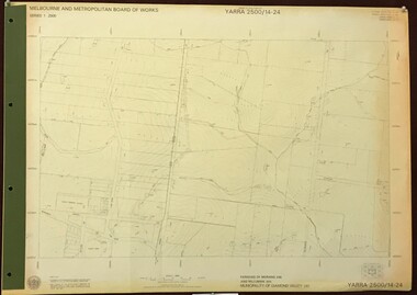 Greensborough Historical Society
Map, Melbourne and Metropolitan Board of Works. Survey Division, MMBW, Yarra 2500 / 14.24. Plenty, 1979_05
Melbourne and Metropolitan Board of Works. Yarra 2500 [base map] 14.24. Plenty. Parishes of Nillumbik 3310 and Morang 3183. Municipality of Diamond Valley 257. Prominent streets include: Heard Road, Hillmartin Road and Yan Yean Road. Features include Plenty Primary School and Plenty Park.MMBW Map in 1:2500 [scale] series. Cream parchment with green tape reinforcing on edges and punched holes on left edge.mmbw, melbourne and metropolitan board of works, shire of diamond valley, plenty - maps -
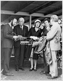 Eltham District Historical Society Inc
Photograph, P. J. Catchlove, Visit to the Shire by the Governor of Victoria, His Excellency Sir Rohan Delacombe, 19 September 1973
The State Governor Sir Rohan Delacombe and Lady Delacombe visited the Shire of Eltham where they were entertained to a civic luncheon by the Shire President Cr. L. E. Clarke and councilors at the Panton Hill hotel and made a tour of the shire. Sir Rohan opened Shillinglaw Cottage at Eltham Town Park.This photo forms part of a collection of photographs gathered by the Shire of Eltham for their centenary project book, "Pioneers and Painters: 100 years of the Shire of Eltham" by Alan Marshall (1971). The collection of over 500 images is held in partnership between Eltham District Historical Society and Yarra Plenty Regional Library (Eltham Library) and is now formally known as 'The Shire of Eltham Pioneers Photograph Collection.' It is significant in being the first community sourced collection representing the places and people of the Shire's first one hundred years.Digital imagesepp, shire of eltham pioneers photograph collection, eltham, governor of victoria, sir rohan delacombe -
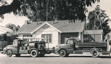 Eltham District Historical Society Inc
Photograph, Hugh Fisher, Eltham Fire Station, east side of Main Road, 1950s, 1950s
The Eltham Fire Station was opened in 31 April 1935. Years later the building was removed and erected for use of 1st Research Scout Group in Research Park by the early 1970s to make way for the Eltham Village Complex which was under construction by 1971. The Research Scout Hall was destroyed by fire in 2002.Black and white photographPhoto by Hugh Fischer, c.1950seltham, fire station, main road -
 Eltham District Historical Society Inc
Photograph, Wattletree Road Bridge, Eltham, c. August 1977, 1977
Traffic island at intersection is lined with white-painted bluestone edging which originally was part of the Eltham lock-up situated at 728 Main Road. The bluestone has since been re-used (from late 1980s) at the rear of 728 Main Road to form the garden bed in car park. Colour photographeltham, infrastructure, main road, shire of eltham infrastructure, wattletree road bridge, bridge -
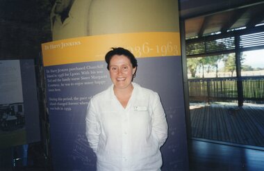 Churchill Island Heritage Farm
Photograph - Photograph of standing woman
Churchill Island Heritage Farm has a large collection of photographs dating from the nineteenth century. The woman in this photograph is Sally O'Neill. The Special Projects officer for Phillip Island Nature Parks, Sally stands in front of the new interpretive exhibitions at the newly opened Churchill Island Visitor Centre in 2001.Photograph of a woman standing in front of a Visitors' Centre display for Dr Harry Jenkinscatalogue number written on reverse in pencilchurchill island, photograph, sally o'neill -
 Stawell Historical Society Inc
Photograph, St. Matthew’s Presbyterian Church from across Scanlan Street
View of St. Matthew’s Church taken from across Scallan Street. From the angle it would seem to have been taken from Cope Car Park. This cyclone fence that can be seen out the front of the church was donated by Mitchell Family members and was mentioned page 46 in Centenary Book.View of St Matthew's Church taken at a slight angle from the front of the church. Photograph looks to be taken from across the street in another front yard with a wooden picket fence. A cyclone fence can be seen on the church just behind the picket fence on opposite front garden. stawell religion