Showing 8867 items matching " construction"
-
 Hymettus Cottage & Garden Ballarat
Photograph, Church group, 14/06/2020
This group of buildings all of which served as churches at different periods is one of the best visual demonstrations of the rapid growth of Ballarat caused by the boom years of the gold rush following the initial alluvial diggings of the 1850s. The smallest church was built in 1861 followed by the next built in 1867 and finally the construction of the grand church on the corner of Neil and Macarthur streets Soldiers' Hill in the 1890s.methodist church, uniting church, soldiers hill, ballarat. -
 Melbourne Tram Museum
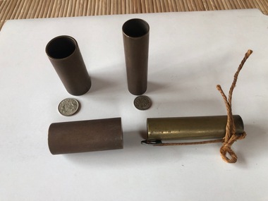
Functional object - Brass coin holder - 3d and 6d
Used by tramway revenue clerks, most likely the MMTB to count coins, as only so many 3d or 6d would fit into each container. Each has a hole in the base to enable it to be checked that it was empty prior to use or after being used. One of the 3d containers have a loose "washer" which shows the nature of the construction. Has been secured with a piece of string.Demonstrates the methodologies used to count coins and stack them in a revenue office. Provides a sample of each coin that would have been used.Brass coin holder - for use in counting 3d and 6d coins. Made from brass tube with a brass washer rolled or fixed to one end. In storage bag is a 3d and a 6d coin. 5 x 6d and 6 x 3d holders held in the collection.See physical descriptiontramways, tickets, cash handling, depots, revenue clerks, coins -
 Melbourne Tram Museum
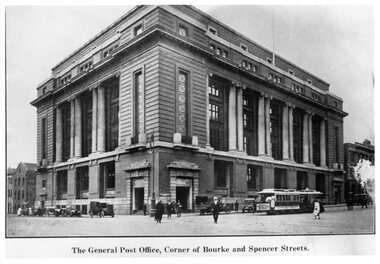
Photograph - Black and White - Mail Exchange Spencer and Bourke Streets c1920
Photo of the Mail Exchange Building with a cable tram loading prior to departure and a number of motor vehicles. The photo shows the monumental construction for the then Post Master Generals Department. This building was completed in 1917 to replace the mail sorting functions of the GPO on the corner of Bourke and Elizabeth St. It had tunnels that connected with Spencer Street Railway station opposite and was designed for the sorting and transporting of mail.Yields information about the Mail Exchange building.Photograph - Black and White - Mail Exchange Spencer and Bourke Streets c1920tramways, trams, cable cars, bourke street, spencer street, post office, post master general, mail exchange -
 Melbourne Tram Museum
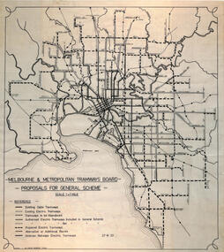
Drawing, Robert Green, Melbourne and Metropolitan Tramways Board Proposals for General Scheme, 2-1968
Drawing prepared by Robert Green for the TMSV showing the MMTB Proposals for tramway construction in the Melbourne Metropolitan Area. Traced and redrawn from the original drawing dated 27-8-1923. Shows the proposed tram lines submitted to Parliament for the report into the General Scheme as required by the MMTB Act when it was formed. See items 2088 for the original report and 2089 for a coloured print of this plan. Demonstrates the MMTB General scheme and a copy that could be used to produce further copies.Drawing - ink on mylar film.trams, tramways, mmtb, general scheme, development, parliamentk, map -
 Kiewa Valley Historical Society
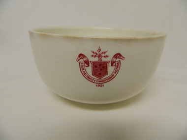
Bowl Ceramic - SECV
This bowl was used by the SECV in their mess rooms for workers during the construction of the Kiewa Hydro Electric Scheme. The imprint of the year '1921' was to identify the year that the SECV was formed which relieved the private VHEC (Victorian Hydro-Electric Company). As the scheme was of such a huge scope, isolated and time consuming nature, the feeding of its workers was quite demanding of cutlery and crockery. (See more KVHS 0113)This bowl was used by SECV workers working on the Kiewa Hydro Electric Scheme (1938 - 1961) in camps and mess halls and at the Mt Beauty chalet. (See more KVHS 0113)This item is a white ceramic State Electricity Commission of Victoria bowl. It is made in England and is of strong and durable ceramic. The 5 mm thickness of the ceramic suggests this bowl (cereal / soup) belongs to a commercial kitchen environment and not domestic. The indent bottom of the bowl is 5 mm deep with a side curvature ratio of 2:5. The ceramic is glazed to a commercial standard (workers' mess). See also KVHS 0128 (B - D) for other ceramic crockery.The red printed seal of the State Electricity Commission of Victoria is imprinted on the top outside rim within a curved scroll and a raised fist with electrical "Charges" extending out. Snuggled within the borders of the scroll is a banner with the 5 stars of the Southern Cross. On the underside "Vitrified sold by Cafe & Hotel Supplies Pty Ltd Dunn Bennett & Co. Ltd. Burslem. Made in Englandcrockery; state electricity commission of victoria; dunn bennett pty. ltd.; bowl -
 Eltham District Historical Society Inc
Photograph, Demolishing the Bini Shell at Diamond Creek, 1991, 1991
In 1978 Diamond Valley Shire recognised the need for a new public hall in Diamond Creek. Council considered the Bini shell form of construction which was in operation overseas and in use in New South Wales as libraries, gymnasiums, sports centres and multi-purpose centres. The Council gave the go-ahead. A site was chosen opposite the Hotel and close to the railway line. One day in - the following year, in 1979, activity stood still in Diamond Creek as school children and other excited spectators watched the one-hour inflation of the Bini Shell. This unusual method of construction was invented by Italian industrial designer and architect Dante Bini. The construction pneumatically raises a level of reinforced concrete from ground level which has not been set, using an internal balloon. The inner membrane inflates and compresses the mesh and concrete against the outer membrane. A net of flexible steel rods was laid on the building’s circular base, on the top of a fabric bladder. 300 tonnes of reinforced concrete were poured onto the mesh and a sealed cover laid over the concrete making a sandwich of cover, bladder and mesh. Compressed air was pumped into the bladder and the sandwich slowly began to rise and become a massive self-supporting dome. After inflation and removal of the outer membrane workmen filled in any holes. It was some days before pneumatic drills pecked out the first opening. The ceiling of the concrete dome was lined with fluffy insulating material. The dome was 36 metres in diameter at the base and 12 metres high in the centre with a usable floor space of 670 square metres. An opening night dinner was held to celebrate the new facility on March 12, 1980. Shire President Ron Pata made a speech and unveiled a plaque. It was the first public building in Victoria to be erected using the Bini Shell design method of construction The facility could cater for up to 400 people and in 1980 a fee for use was $100 for up to 200 people, $150 for up to 300 people and $200 for up to 400 people. For the next ten years or so, locals attended the hall for marital arts classes, basketball and netball games and school discoes and various other activities. After pieces of concrete fell off a Bini shell interstate due to a construction fault, the Council closed the centre. Demotion took place during the Diamond Creek Town Fair in 1991, as part of the annual Town Fair’s program. Research by L.P. Jan 2022This was the first public building in Victoria to be erected using the Bini Shell design method of construction.Colour photograph1991, diamond creek, bini shell, demolition, oval -
 Eltham District Historical Society Inc
Photograph, Fred Mitchell, Bini Shell at Diamond Creek, 1983, 1983
In 1978 Diamond Valley Shire recognised the need for a new public hall in Diamond Creek. Council considered the Bini shell form of construction which was in operation overseas and in use in New South Wales as libraries, gymnasiums, sports centres and multi-purpose centres. The Council gave the go-ahead. A site was chosen opposite the Hotel and close to the railway line. One day in - the following year, in 1979, activity stood still in Diamond Creek as school children and other excited spectators watched the one-hour inflation of the Bini Shell. This unusual method of construction was invented by Italian industrial designer and architect Dante Bini. The construction pneumatically raises a level of reinforced concrete from ground level which has not been set, using an internal balloon. The inner membrane inflates and compresses the mesh and concrete against the outer membrane. A net of flexible steel rods was laid on the building’s circular base, on the top of a fabric bladder. 300 tonnes of reinforced concrete were poured onto the mesh and a sealed cover laid over the concrete making a sandwich of cover, bladder and mesh. Compressed air was pumped into the bladder and the sandwich slowly began to rise and become a massive self-supporting dome. After inflation and removal of the outer membrane workmen filled in any holes. It was some days before pneumatic drills pecked out the first opening. The ceiling of the concrete dome was lined with fluffy insulating material. The dome was 36 metres in diameter at the base and 12 metres high in the centre with a usable floor space of 670 square metres. An opening night dinner was held to celebrate the new facility on March 12, 1980. Shire President Ron Pata made a speech and unveiled a plaque. It was the first public building in Victoria to be erected using the Bini Shell design method of construction The facility could cater for up to 400 people and in 1980 a fee for use was $100 for up to 200 people, $150 for up to 300 people and $200 for up to 400 people. For the next ten years or so, locals attended the hall for marital arts classes, basketball and netball games and school discoes and various other activities. After pieces of concrete fell off a Bini shell interstate due to a construction fault, the Council closed the centre. Demotion took place during the Diamond Creek Town Fair in 1991, as part of the annual Town Fair’s program. Research by LP January 2022This was the first public building in Victoria to be erected using the Bini Shell design method of construction.Digital copy of colour photographfred mitchell collection, 1983, bini shell, diamond creek -
 Federation University Historical Collection
Book - Class Notes, A History of Architecture Grade I by R.D. Fraser, 1948, 1948
R.D. Fraser was a student of the Ballarat Technical Art School, a division of the Ballarat School of Mines. Numerous hand written and hand drawn class notes from from the Ballarat Technical Art School. Topics include: Egyptian Architecture, Greek Architecture (BC300-BC700), Etruscan Architecture (BC750-BC100) and Roman Architecture (BC146-BC365) Early Christian Architecture Images include: Egypt, Great Pyramids, rock cut tombs, catacombs, Egyptian Temples, Development of a Pyramid, Egyptian Construction Methods, Greece, Greek Temples, Sloping Roofs, Doric Temples, Temple of Poseidon, Parthenon, arches, Acropolis Athens, Partenon, Ionic Volute, Propylaea, Erechtheion Athens, Corinthian examples, Greek Theatre, Optical Corrections in Architecture, The Greek House, Temple of Fortuna Virilis Rome, Maison Caree Nimes, Roman Circular Temples, Basilica of Trajan, Column of Trajan, Colosseum Rome, Basilica of Constantine, Roman Arched Structures, Romas Thermae at Romes, Arch and Wall construction, columns, mouldings Clemente Rome, S. Paolo Fuori le Mura Rome, Baptistery of Constantine Rome, S. Constanza Romearchitecture, art history, ballarat technical art school, r.d. fraser, alumni -
 Kew Historical Society Inc
Plan, Melbourne & Metropolitan Board of Works : Borough of Kew : Detail Plan No.1578, 1904
The Melbourne and Metropolitan Board of Works (MMBW) plans were produced from the 1890s to the 1950s. They were crucial to the design and development of Melbourne's sewerage and drainage system. The plans, at a scale of 40 feet to 1 inch (1:480), provide a detailed historical record of Melbourne streetscapes and environmental features. Each plan covers one or two street blocks (roughly six streets), showing details of buildings, including garden layouts and ownership boundaries, and features such as laneways, drains, bridges, parks, municipal boundaries and other prominent landmarks as they existed at the time each plan was produced. (Source: State Library of Victoria). This plan forms part of a large group of MMBW plans and maps that was donated to the Society by the Mr Poulter, City Engineer of the City of Kew in 1989. Within this collection, thirty-five hand-coloured plans, backed with linen, are of statewide significance as they include annotations that provide details of construction materials used in buildings in the first decade of the 20th century as well as additional information about land ownership and usage. The copies in the Public Record Office Victoria and the State Library of Victoria are monochrome versions which do not denote building materials so that the maps in this collection are invaluable and unique tools for researchers and heritage consultants. A number of the plans are not held in the collection of the State Library of Victoria so they have the additional attribute of rarity.Original survey plan, issued by the MMBW to a contractor with responsibility for constructing sewers in the area identified on the plan within the Borough of Kew. The plan was at some stage hand-coloured, possibly by the contractor, but more likely by officers working in the Engineering Department of the Borough and later Town, then City of Kew. The hand-coloured sections of buildings on the plan were used to denote masonry or brick constructions (pink), weatherboard constructions (yellow), and public buildings (grey). MMBW Plan No.1578 is significant in that it defines the extent of two private schools: Xavier College and Kew High School (now part of Trinity Grammar) by 1904. In relation to the latter, the plan clarifies which buildings the High School operated from behind the mansion ‘Molina’. Established in 1902, Trinity Grammar was to later lease and subsequently buy Molina (now ‘Merritt House’) and ‘Elsinore’ (now ‘Roberts House’). Xavier College had been established in 1872. This 1904 plan delineates the West Wing and the Great Hall (built in 1890).melbourne and metropolitan board of works, detail plans, maps - borough of kew, mmbw 1578, cartography -
 Kew Historical Society Inc
Plan, Melbourne & Metropolitan Board of Works : Borough of Kew : Detail Plan No.1590, 1905
The Melbourne and Metropolitan Board of Works (MMBW) plans were produced from the 1890s to the 1950s. They were crucial to the design and development of Melbourne's sewerage and drainage system. The plans, at a scale of 40 feet to 1 inch (1:480), provide a detailed historical record of Melbourne streetscapes and environmental features. Each plan covers one or two street blocks (roughly six streets), showing details of buildings, including garden layouts and ownership boundaries, and features such as laneways, drains, bridges, parks, municipal boundaries and other prominent landmarks as they existed at the time each plan was produced. (Source: State Library of Victoria)This plan forms part of a large group of MMBW plans and maps that was donated to the Society by the Mr Poulter, City Engineer of the City of Kew in 1989. Within this collection, thirty-five hand-coloured plans, backed with linen, are of statewide significance as they include annotations that provide details of construction materials used in buildings in the first decade of the 20th century as well as additional information about land ownership and usage. The copies in the Public Record Office Victoria and the State Library of Victoria are monochrome versions which do not denote building materials so that the maps in this collection are invaluable and unique tools for researchers and heritage consultants. A number of the plans are not held in the collection of the State Library of Victoria so they have the additional attribute of rarity.Original survey plan, issued by the MMBW to a contractor with responsibility for constructing sewers in the area identified on the plan within the Borough of Kew. The plan was at some stage hand-coloured, possibly by the contractor, but more likely by officers working in the Engineering Department of the Borough and later Town, then City of Kew. The hand-coloured sections of buildings on the plan were used to denote masonry or brick constructions (pink), weatherboard constructions (yellow), and public buildings (grey). Surveyed by the Board of Works in 1903 and published in 1904, Plan No.1590 shows development north of Cotham Road. While this plan includes built structures in Mary Street, Cotham Road, High Street, Park Hill Road, Kent Street, Ridgeway Avenue, and Ermington Lane (now Ermington Place), only part of this section was notated and coloured in this contractor’s copy. Numerous houses, large and small are named on the plan: ‘Cholula’, ‘Belper’, ‘The Uplands’, ‘Spring Grove’ facing Cotham Road; ‘Marion’ facing Kent Street; and ‘Kia Ora’ facing Ridgeway Avenue.melbourne and metropolitan board of works, detail plans, mmbw 1590, survey plans - borough of kew, cartography -
 Melbourne Tram Museum
Document - Radio Transcript, Melbourne & Metropolitan Tramways Board (MMTB), Wireless talk - "inside information regarding tramcars", Jul. 1926
Radio transcript - 12 foolscap sheets, typed. Although not named, appears to have been prepared for or by Mr. Strickland describing "inside information regarding tramcars". Notes cable trams, conversion, sale of trailers and dummies or grip cars, the variety taken over from the trusts, design of new cars (180 in service at the time of the report), open cars vs closed cars, seating and standing capacity, speed, braking system, step heights, destination signs, lifeguards. Gives a description of Preston Workshops, finishing soon, description of the tramcar construction, roofing, painting, sourcing of materials, timbers, cost per tram of 3250 pounds, depots, breakdowns, overhauls, workshops, collision repairs in 1925, construction of 10 safety cars. Vicsig.net gives that X1 461 entered service in Sept. 1926. Pinned to the file by Robert on the rear of TMSV Raffle ticket is a note "Electrical Engineer 15/7/26 p35 "C. H. Wickham gave recent address broadcast on 3LO"In blue pencil in top left hand corner appears to be "Wickham"trams, tramways, tramcars, preston workshops, new trams, sale of trams, cable trams, destination roll, tram brakes, tramcar equipment, x1 class, w class, depots, radio stations -
 Kiewa Valley Historical Society
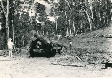
Photo - Mountain Creek Logging Camp, 1955
Hume and Hovell discovered the area in 1824 and by the end of the 19th century the valley was transformed by logging, dairy and beef cattle properties and tobacco farms. The logs could have been milled for timber at the State Electricity Commission's mill at Howman's Gap which provided a much needed source of timber for construction of McKay Creek Power Station which began construction in 1951 and also the camps and houses for the workers and their families. There was a need for housing and infrastructure for an increasing population of workers for the hydro-electric scheme as there was a general shortage of this commodity. A timber mill was started in Tawonga by Mates, of Albury, in 1945, and electricity became available in 1946 the S.E.C. bought the mill, and enlarged it. In 1960 it was purchase by a local family, they also started a timber mill in Mt Beauty worked both until 1980 when they closed it. The Tawonga mill and enlarged the mill called Mt. Beauty Timbers Pty Ltd employed approximately 50 people. An historical pictorial record of the general working conditions, type of machinery and vehicles in use in the 1950’s. Note the lack of protective clothing!Black and white photograph of the logging camp at Mountain Creek. November 1955Handwritten on the back of photograph - MOUNTAIN CREEK LOGGING CAMP NOV 55mountain creek logging camp, timber industry, tawonga -
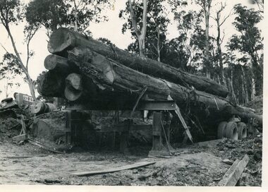 Kiewa Valley Historical Society
Photo - Logging. Mountain Creek, November 1955, November 1955
Hume and Hovell discovered the area in 1824 and by the end of the 19th century the valley was transformed by logging, dairy and beef cattle properties and tobacco farms. The logs could have been milled for timber at the State Electricity Commission's mill at Howman's Gap which provided a much needed source of timber for construction of McKay Creek Power Station which began construction in 1951 and also the camps and houses for the workers and their families. There was a need for housing and infrastructure for an increasing population of workers for the hydro-electric scheme as there was a general shortage of this commodity. A timber mill was started in Tawonga by Mates, of Albury, in 1945, and electricity became available in 1946 the S.E.C. bought the mill, and enlarged it. In 1960 it was purchase by a local family, they also started a timber mill in Mt Beauty worked both until 1980 when they closed it. The Tawonga mill and enlarged the mill called Mt. Beauty Timbers Pty Ltd employed approximately 50 people An historical pictorial record of the general working conditions, type of machinery and vehicles in use in the 1950’s. Black and white photograph of logging at Mountain Creek November 1955Small typed note attached to the back of photo - Logging Mountain Creek November 1955mountain creek logging camp, tawonga, timber industry -
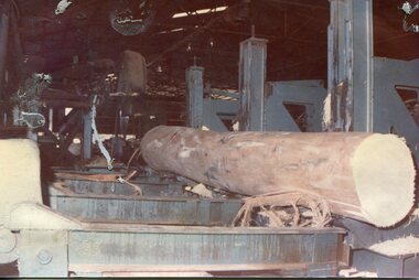 Kiewa Valley Historical Society
Photographs - 2 Colour photographs of logs being harvested and milled for timber in the Kiewa Valley
: Hume and Hovell discovered the area in 1824 and by the end of the 19th century the Kiewa Valley was transformed by logging, dairy and beef cattle properties and tobacco farms. The logs could have been milled for timber at the State Electricity Commission's mill at Howman's Gap which provided a much needed source of timber for construction of McKay Creek Power Station which began construction in 1951 and also the camps and houses for the workers and their families There was a need for housing and infrastructure for an increasing population of workers for the hydro-electric scheme as there was a general shortage of this commodity. A timber mill was started in Tawonga by Mates, of Albury, in 1945, and electricity became available in 1946 the S.E.C. bought the mill, and enlarged it. In 1960 it was purchase by a local family, they also started a timber mill in Mt Beauty worked both until 1980 when they closed the Tawonga mill and enlarged the mill called Mt. Beauty Timbers Pty Ltd which employed approximately 50 people. An historical pictorial record of the type of machinery and vehicles in use in the 1950’s to harvest and mill the logs from surrounding forested areas.1. Colour photograph of large logs being milled for timber at a timber mill 2. Colour photograph of heavy machinery being used to harvest large logs for milling timber; timber mill; kiewa valley; forests; logging -
 Bacchus Marsh & District Historical Society
Map, Plan of part of the road district of Bacchus Marsh circa 1856-1862
Local government in much of Victoria including the Bacchus Marsh area began with the formation of 'local committees'. These local committees could make representations to a Central Road Board regarding plans for road construction. Road construction and maintenance were seen as the essential tasks of these early local government authorities. By 1856 the local committee in Bacchus Marsh was constituted as the Bacchus Marsh Road District. This entity continued until 1862 when the name changed to the Bacchus Marsh and Maddingley Road District. This new entity lasted until 1871 when the local government authority in accordance with new statewide legislation became known as the Shire of Bacchus Marsh. The title of this plan being a plan of 'a portion of the road district of Bacchus Marsh' suggests that the plan was produced sometime between 1856 and 1862. The main purpose of this map was to shown the irrigable land in the district and the sources from which water for irrigation could be drawn. Bacchus Marsh was an early irrigation district in Victoria. Irrigation trusts were formed in the 1880s and 1890s to manage irrigation districts. But this was the culmination of many years of earlier attempts to construct irrigation systems in the Bacchus Marsh area and create a system to manage irrigation more broadly. This map dating from around 1856-1862 is an important cartographic document which provides evidence of how the early planning for irrigation was developing in the Bacchus Marsh region.A single page paper map showing a plan of part of the road district of Bacchus Marsh. The map is pasted into a bound volume containing 76 maps or plans in total. High resolution digital image stored on BMDHS computer network. bacchus marsh victoria maps, bacchus marsh road district, local government, road districts, irrigation -
 Tarnagulla History Archive
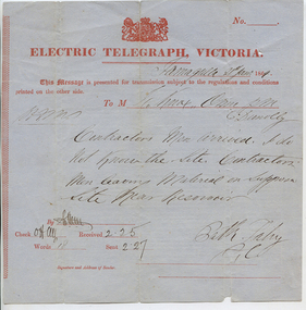
Telegram: Fahy to Dunolly, 21st January 1864
Murray Comrie Collection. A telegram sent from a Bill (?) Fahy in Tarnagulla to a recipient in Dunolly on 21st Jan 1864. Notifies recipient that 'contractors men arrived'. Author says 'i do not know the site. Contractors men leaving material on supposed site near Reservoir'.tarnagulla, post office, telegrams, chief secretary, fahy, construction, reservoir, recreation reserve, workers, work -
 Wangaratta RSL Sub Branch
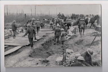
Postcard, 1917
From the album of WWI soldier William West (1268) of the 29 Infantry Battalion, 5th Pioneers Battalion. This collection of postcards, photographs and clippings were sent between William and his family and loved ones during the years he was on active service. See also 207 and 220. Postcard with a black and white photograph of soldiers constructing a roadway at the front. Handwritten message on the back.album, photo album, newspaper clippings, postcard, wwi, photograph, soldier, the front, road, construction -
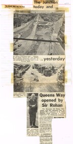 Melbourne Tram Museum
Newspaper, The Sun, The Herald, "The Junction today and Yesterday", "The Street that died" "Fare Rises attacked, Dec. 1968
Newspaper Clipping - set of four clippings adhered to two sides of two sheets of ruled quarto paper with punched holes on the left hand side - from newspaper about the St Kilda Junction tram and road works. 1 - "The Junction today and Yesterday", with photos of the St Kilda junction on 11/12/1968 and 1920, following the opening of Queens Way (road under the tram tracks_ by The Governor Sir Rohan Delacombe - from the Herald 11/12/1968. 2 - Keith Dunstan's a Place in The Sun about his visit to Brisbane and the closure of the Brisbane Tramway System - The Sun 11/12/1968 3 - "The Street that died" - the Sun 19/12/1968 - about the about the closure and removal of the tram tracks in Wellington St and its effect on the businesses. Has a photo of Frances Robinson of the St Kilda Post Office walking across demolished track tracks and wooden blocks. 4 - Trams - 20/12/1968 - about trams shunting at Malvern Depot 5 - two newspaper cuttings - "Fare Rises Attacked" - Monday 20-12-1968 - about proposed Fare Rises - quotes the Minister Mr Wilcox.trams, tramways, st kilda junction, opening, brisbane, road works, construction, malvern depot, wellington st, fares -
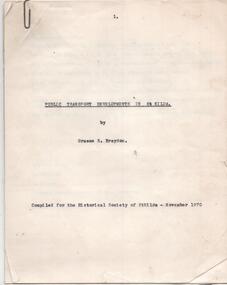 Melbourne Tram Museum
Document - Report, Graeme Breydon, "Public Transport Developments in St Kilda", Nov. 1970
Carbon copy of a report - 10 quarto pages + two heat sensitive copied maps titled "Public Transport Developments in St Kilda", prepared by Graeme Breydon Nov 1970 for the Historical Society of St Kilda. Looks at the development of tram transport, cable trams, railways, Hobson's Bay loop line, electrocution of the railways and tramways, some features e.g. shelters, developments and freeway proposals. Maps show rail and tramways on the eastern side of Melbourne.trams, tramways, city of st kilda, victorian railways, pmtt, vr, st kilda brighton, construction, railways, cable trams -
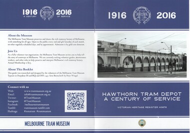 Melbourne Tram Museum
Book, Adam Chandler, "Hawthorn Tram Depot a Century of Service", Jul. 2016
Colour printed book - 8 pages, A5 size, centre stapled, printed on heavy paper, titled "Hawthorn Tram Depot a Century of Service", providing details of the Hawthorn Tram depot, the Hawthorn Tramway Trust, HTT, it services, substation, opening, amalgamation, uniforms and redevelopment. Has the details of the Museum on the rear cover. Prepared by Adam Chandler July 2016. Printed for sale at the 2016 Melbourne Open House depot.trams, tramways, hawthorn, fohtd, depots, pamphlets, htt, substation, uniforms, construction -
 Melbourne Tram Museum
Book - Malvern Tramways Trust Act and other documents, Victorian Parliament, c1911
Contains: "An Act to consolidate and amend the Prahran and Malvern Tramways Trust Acts and for other purposes" - dated 4/1/1911 Order in Council for Malvern trams detailing requirements of the tramway, dated 6/7/1908 - two different orders - gives details of the tramway eg gauge, speed, crossing of railways and relationship with the MTOCo. All documents scanned to pdf - text searchable.Yields information about the legal status of the PMTT to run tramways.Book - 16 pages, bound with red leather style covers.Has "H.S. Dix" in ink on the top right hand corner of the first page.trams, tramways, tramways, acts of parliament, pmtt, malvern, prahran, construction, mto co, order in council -
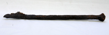 Orbost & District Historical Society
bridge spike
This spike came from the old Brodribb River bridge which is about 9.6 kilometres from Orbost. The Brodribb River joins the Snowy River north of Marlo. In 1906, a bridge replaced the punt over the Brodribb River, improving communication with Orbost. It was eventually replaced by a reinforced concrete bridge built by the Road Construction Authority in 1989 where the Princes Highway passes over the Brodribb RiverThis item belongs to a significant local structure which has been replaced.A very rusty iron bridge spike from the old Brodribb Bridge.brodribb-river bridge-spike -
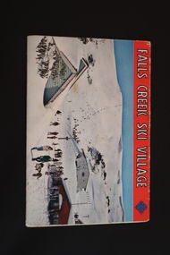 Kiewa Valley Historical Society
Souvenir Postcard Folder – Falls Creek Ski Village
Falls Creek Ski Resort developed during the construction of the Kiewa Hydro Electric Scheme built by the State Electricity Commission of Victoria. The first ski lodge was built in 1948 by workers from the scheme. The first lift, a rope tow, was built in 1951 and the first chairlift in Australia was constructed there in 1957. Falls Creek Post Office opened in 1958. Tourism was growing and being encouraged by local businesses.The souvenir postcard was produced by Mr S. K. Pearce a Mt Beauty businessman. It was a memento for skiers and visitors to the Falls Creek and Mt Beauty area to send to family and friends as a reminder of their visit to the region or to keep as a personal souvenir. It presented an excellent promotional opportunity for enterprising local businessmen to promote the area to skiers and tourists near and far. It also presents an excellent pictorial history of the Falls Creek area around the late 1950's and 1960's.Colour postcard folder (unused) containing 12 labelled colored photos of the Falls Creek ski area and surrounds with a blank 'page' entitled 'Correspondence' and another for the address.falls creek, skiing, snow sports, s. k. pearce, tourism, secv -
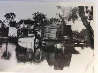 Port of Echuca
Photograph, Early 20th Century
The P.S Australien was built in 1897 by Richard Wilson, of Moama. In 1937 the vessel was used to tow boilers, winches and derricks to the banks of the Murray River to aide in the construction of Locks 6,7,9 and Yarrawonga Weir. The barge is viewed from the rear, as the rudder can be seen, and shows the enormity of the loads of wool which a barge could carry. The two vessels are tied together and appear to be moored at a small pier.The P.S Australien is one of the oldest paddle steamers built at Echuca. It was a working vessel during the construction of the Yarrawonga weir in the 1930s which was the beginning of the irrigation system which enabled the Agriculture Industry to become such a prominent part of the Murray-Darling River Basin social history. A paddle steamer and a barge, loaded with wool, are seen docked together on a river. There is a small wooden jetty leading to the bank where gum trees are growing.p.s australien, yarrawonga weir, echuca paddlesteamers, murray river paddle steamers, wilson, richard, wool industry -
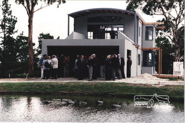 Eltham District Historical Society Inc
Photograph, Launch of the Kinloch Gardens development, 93 Arthur Street, Eltham, April 1998, April 1998
Brand new home under construction by Vizarje Homes, Greensborough at the launch of the Kinloch Gardens development, 12 new double and triple storey homes along a private road in the gardens of Kinloch, a mansion set on 2.4ha in Arthur St. The launch was attended by Planning Minister Rob Maclellan and Nillumbik Shire president Robert Marshall, Architects Graeme Gunn and Ian Jelbart and approximately 100 guests.7 images; digital file only; created from scan undertaken by EDHS of a set of 29 colour 10 x 15 cm prints vizarje homes, arthur street, jelbart property, kinloch, woodridge estate -
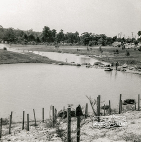 Eltham District Historical Society Inc
Photograph, Looking north across Eltham Town Park, 1974, 1974
Visible are Trestle Bridge, Eltham Shire Offices with south wing extension, duplicated Main Road, Panther Place and the pathway through the park. Shillinglaw Cottage in Eltham Common on the other side of Panther Place is hidden from view by the tree-capped grassy knoll. The two ponds were in construction during the Arbor Day native tree planting by local school children in October 1973.Black and white photographeltham town park, eltham shire office, main road, shillinglaw trees, trestle bridge -
 Geelong RSL Sub Branch
History of Colin Quin, Late 20th Century
Colin Quin was a National Serviceman in the 1958 intake upon completion of National Service Colin Quin joined the Regular Army. Colin served with the 21st Construction Engineers the unit went to Wewak, Borneo. After Military Service Colin worked as a refrigeration mechanic and has the interesting hobby of making model aeorplanes from beer cans. Colin Quin is also a distant relative to Ned Kelly.This is the original story of Colin Quin.A detailed A4 paper discription of Colin Quin a National Serviceman in 1958 and commenced training in the 20 National Service Battalion. Colin Quinn and joined the Regular Army after completion of National Service. -
 Kiewa Valley Historical Society
Photograph of Pretty Valley Camp, Pretty Valley Camp, circa 1948
At the Pretty Valley Dam site erection of staff quarters was completed in April, 1947 and accommodation for workmen commenced in 1948 but suspended on 11th May for winter and resumed on 9th November. Construction of this camp was completed in 1949. A large dam was proposed at this site but was never constructed. Instead a small diversion dam was built which diverts water either to Rocky Valley Dam or to McKay Creek Power Station.An historical record of the type of accommodation provided for workmen during the construction of the Kiewa Hydro Scheme during the 1940's/50'sBlack and white photograph of Pretty Valley Camp showing general terrain and the huts built to accommodate workmen employed on the Kiewa Hydro Electric Scheme.pretty valley, dam, water, workmen, camp -
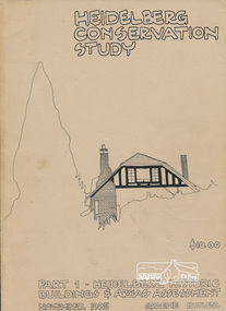 Eltham District Historical Society Inc
Book, Graem Butler, Heidelberg Conservation Study, Part 1 Heidelberg Historic Buildings and Areas Assessment by Graeme Butler, November 1985
Historic Buildings and Areas Assessment by Graeme Butler. Part 1 of award winning study carried out in 1982 in collaboration with a community advisory committee to Heidelberg City Council. Pioneering identification of a broad range of heritage assets varying from buildings, gravestones, farm structures, landscape areas, mileposts, divided street construction, in a time when buildings only were assessed in municipal studies.2 v. : ill., maps ; 29 cm.significant buildings heidelberg victoria, history development of heidelberg victoria, man-made landscape heidelberg victoria, significant precincts heidelberg victoria, conservation study, graeme butler -
 Orbost & District Historical Society
black and white photograph, 1920s
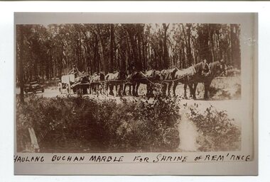
The Shrine of Remembrance was created to meet the needs of a grieving community after the extensive loss of lives in the First World War (1914 –18). sixteen dark Buchan marble Ionic columns. In the early 1900s black marble was being mined in the Bruthen district. Some was used for the Shrine of Remembrance in Melbourne and Australia House in London. 900 tonnes were shipped to London to be included in the construction of Australia House. Marble quarrying has been a significant part of the history of Buchan in East Gippsland. Its inclusion in the Shrine of Remembrance War Memorial is noteworthy.A black / white photograph of a team of eight horses hitched to an open top cart. The cart is loaded with lrge slabs of marble. The driver is on top of the load. It is on a gravel road in a forest. The photograph has a grey frame background.om front - "HAULING BUCHAN MARBLE FOR SHRINE OF REM'ANCE"marble-buchan quarry-marble-south-buchan shrine-of-remembrance