Showing 10534 items matching "sectioning"
-
 Flagstaff Hill Maritime Museum and Village
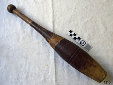
Equipment - Juggling Club, late 19th to early 20th century
This wooden juggling club or exercise club may also be referred to as a juggling pin. It is very similar in shape to a bowling pin or an Indian club. It dates approximately to the early 20th century. It may have been used as one of a pair for gymnastics or exercise, or part of a larger set used by a juggler for entertainment in a circus or carnival. At some time it may have been used with a ball or disc as part of a Skittles or bowling game set. The historical collection of Federation University Australia, Victoria, includes a very similar but slightly shorter club, labelled ‘timber skittle”, as can be seen in their photograph. Another example of very similar-shaped, same-sized clubs can be seen in the collection of Nobelius Heritage Park and Emerald Museum, Emerald, Victoria. JUGGLING Jugglers entertain audiences with their tricks and routines at events such as circuses, amusement parks, parties, shows on television or theatre, schools and parties. Juggles also compete at International Championships to obtain world records, performing as individuals or in groups or teams. Contemporary champion juggler David Cain performs a Juggling History Show that both entertains and educates his audience. His routines date from the early 1600s to the 20th century. He uses a wide variety of equipment in his acts including juggling clubs. EXERCISE Exercise clubs or Indian clubs were used in 19th century Victorian times as part of exercise or strengthening programs when they were swung in certain patterns and movements. Even in the early 20th century workplace a few minutes of Indian club swinging was common practice for the relief of tension. A video clip of an American school room in 1904 shows a group of boys and girls skilfully wielding clubs in an exercise sequence (see ‘Links” section). The 1904 and 1932 Olympic Games had an event called Club Swinging. Rhythmic gymnastics was added to the Olympic Program at the L.A. Games in 1984 where competitors use apparatus such as rope, hoop, ball, ribbon and clubs. The clubs come in a variety of weights and heights and have been used from the mid-1800s until around the 1930s in schools and military institutions. They are decorated in a variety of patterns and colours and some have feature lines or scored rings on them. This juggling club is significant for its association with education, entertainment and sport in the late 19th and early 20th century.Wooden juggling club (or pin, skittle or Indian club). Vintage, bottle-shaped club with a flat, slightly concave, base. Its turned, solid timber body tapers out from the base then in again to a very narrow handle with a round knob joined onto the top. Two concentric feature lines are scored into the wider part of club. It was possibly used in exercise, gymnastics or as a skittle. Sections of the club have two brown painted stripes; paint on the lower strip has been worn off at the base . There are remnants of white paint in two areas, possibly the remains of a maker’s name or decoration. There also appears to be an inscription stamped into the wooden handle but this is illegible. Late 19th to early 20th century.Remnants of what appears to be stamped lettering and painted labelling.flagstaff hill, warrnambool, shipwrecked coast, flagstaff hill maritime museum, maritime museum, shipwreck coast, flagstaff hill maritime village, great ocean road, wooden skittle, entertainment, bowling skittle, wooden juggling pin, wooden juggling club, wooden exercise club, indian club, exercise club, club swinging, rhythmic gymnastics, sport equipment, juggling equipment, wooden club -
 Eltham District Historical Society Inc
Slide, Maroondah Aqueduct, Research, Victoria, 22 Mar. 1981
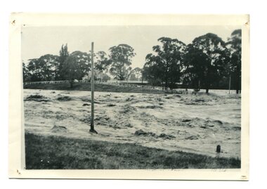
An inspection tour of the Maroondah Aqueduct was undertaken by the Shire of Eltham Historical Society on Sunday, March 22nd, 1981, commening where the aqueduct crosses Main Rd., Research, just below Eltham College. The Maroondah Aqueduct was part of Melbourne’s water supply system. It carried water over the 66 km from the Maroondah Reservoir on the Watts River at Healesville to the Preston Reservoir. Of this length, 41 km were open channel, 10 km, tunnel through hills and 15 km in 14 inverted siphons across stream valleys. The route of the aqueduct is north of Tarrawarra and Yarra Glen, along the Yarra escarpment south of Christmas Hills and crossing Watsons Creek into the present Shire of Eltham near Henley Rd. The eastern part of the route lies entirely within the former boundaries of the shire. The aqueduct passes south of Kangaroo Ground to Research and crosses the Diamond Creek by siphon at Allendale Rd., Eltham North. It then extends to Reservoir via St. Helena, Greensborough North and Bundoora. Water first flowed through the aqueduct in February 1891 when it was fed by a diversion weir on the Watts River. Records of the building of the aqueduct indicate that it was a significant construction achievement. The present Maroondah Reservoir was completed in 1927 and the aqueduct was enlarged at that time to take increased flows. About 1971 the section of the aqueduct through and north of Research was replaced by a large pipe and that section of the channel is now unused. The channel has remained largely intact (unlike sections at Greensborough and Bundoora where long lengths of the disused aqueduct have been demolished or filled in). The M.M.B.W. relinquished control of the disused aqueduct reserve which is crown land and the Shire of Eltham took control of this section of the reserve as a linear park. The Maroondah Aqueduct is considered to be an important historic structure, not just to the local area but to the metropolitan area generally. It is considered important to preserve substantially intact long lengths of the disused aqueduct, together with its bridges and other associated structures. 35 mm colour positive transparency (1 of 5) Mount - Agfachrome Agfa CS System black 8 dotsactivities, heritage excursion, maroondah aqueduct, research (vic.), shire of eltham historical society -
 Eltham District Historical Society Inc
Slide, Maroondah Aqueduct, Research, Victoria, 22 Mar. 1981
An inspection tour of the Maroondah Aqueduct was undertaken by the Shire of Eltham Historical Society on Sunday, March 22nd, 1981, commening where the aqueduct crosses Main Rd., Research, just below Eltham College. The Maroondah Aqueduct was part of Melbourne’s water supply system. It carried water over the 66 km from the Maroondah Reservoir on the Watts River at Healesville to the Preston Reservoir. Of this length, 41 km were open channel, 10 km, tunnel through hills and 15 km in 14 inverted siphons across stream valleys. The route of the aqueduct is north of Tarrawarra and Yarra Glen, along the Yarra escarpment south of Christmas Hills and crossing Watsons Creek into the present Shire of Eltham near Henley Rd. The eastern part of the route lies entirely within the former boundaries of the shire. The aqueduct passes south of Kangaroo Ground to Research and crosses the Diamond Creek by siphon at Allendale Rd., Eltham North. It then extends to Reservoir via St. Helena, Greensborough North and Bundoora. Water first flowed through the aqueduct in February 1891 when it was fed by a diversion weir on the Watts River. Records of the building of the aqueduct indicate that it was a significant construction achievement. The present Maroondah Reservoir was completed in 1927 and the aqueduct was enlarged at that time to take increased flows. About 1971 the section of the aqueduct through and north of Research was replaced by a large pipe and that section of the channel is now unused. The channel has remained largely intact (unlike sections at Greensborough and Bundoora where long lengths of the disused aqueduct have been demolished or filled in). The M.M.B.W. relinquished control of the disused aqueduct reserve which is crown land and the Shire of Eltham took control of this section of the reserve as a linear park. The Maroondah Aqueduct is considered to be an important historic structure, not just to the local area but to the metropolitan area generally. It is considered important to preserve substantially intact long lengths of the disused aqueduct, together with its bridges and other associated structures. 35 mm colour positive transparency (1 of 5) Mount - Agfachrome Agfa CS System black 8 dotsactivities, heritage excursion, maroondah aqueduct, research (vic.), shire of eltham historical society -
 Bendigo Military Museum
Photograph - 4 Fd Svy Sqn Closure Ceremony 25 Nov 1995, 4 Fd Svy Sqn, Keswick Barracks, Adelaide, 25.11.1995
Between 1915 and 1951, military topographical mapping in SA was conducted by Royal Australian Survey Corps (RASvy) units based outside the state. In February 1952, Army HQ Field Survey Section (Central Command Detachment) was established in Adelaide in a drill hall at Largs Bay. It was tasked with providing map coverage in the Woomera and Southern areas of the state. The section was subsequently reorganised as Central Command Field Survey Section moving firstly to Hampstead Barracks, Hampstead in 1953 and then into accommodation at Keswick Barracks in 1954. In 1957 the Section commenced mapping operations in the NT. The Unit was relocated to the old cavalry stables in 1961 and was redesignated Central Command Survey Unit and remained there till 1973. In 1970 the Unit was redesignated 4 Fd Svy Sqn and engaged in operations conducted in PNG from 1972 to 1974 inclusive. In 1973 the Squadron moved into a brand new two-storey specially designed and purpose built building adjacent to the old building. The old building then became the Squadron Q and Map store with an interconnecting lobby to the new building. Since 1975 the Unit was involved in the 1:50,000 Mapping Programme in WA, NT, QLD, SA and conducted many other operations within Australia and overseas. Post disbandment of the Corps the old Squadron building (cavalry stables) now houses the Army Museum of South Australia (AMOSA). The Royal Australian Survey Corps was amalgimated into the Royal Australian Engineer Corps in July 1996. In the lead up to this amalgamation, 4 Field Survey Squadron Keswick Barracks, Adelaide, South Australia was disbanded in 1995. A closing Ceremony was held on 25 November 1995 at 4 Fd Svy Sqn Keswick Barracks attended by about 208 former members of the Unit. A photo was taken of attendees at that event on the day and a list was prepared of attendees. All attendees were sent a copy of the photograph and the list of names as a momento of the Unit and the ceremony..1P A4 Print of an original photo of attendees at the 4 Fd Survey Sqn Closure Ceremony at Keswick Barracks 25 Nov 1995. .2P A4 Print of the names of the attendees at the 4 Fd Survey Sqn Closure Ceremony at Keswick Barracks 25 Nov 1995. Approx 208 attendees.royal australian survey corps, rasvy, fortuna, army survey regiment, army svy regt, asr, 4 fd svy sqn -
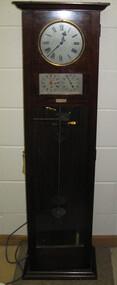 Federation University Historical Collection
Object, Synchronome Co. Ltd, Synchronome Frequency Checking Master Clock No. 2191, c1930
Information from Norman F. Dalton: Ballarat had a reticulated DC supply in the early part of last century and in 1905 had sufficient generating capacity to enable the trams to be changed from horse drawn to DC electricity. The use of electricity increased with the main power station located on Wendouree Parade, near Webster Street, under the ownership of The Electric Supply Company of Victoria. AC generating plant was installed in 1925 and conversion to AC proceeded. In 1934 the company was taken over by the State Electricity Commission Victoria (SECV) and more AC generation was installed and the changeover of customers was accelerated. This is around the time that the Synchronome Frequency Checking Mast Clock was installed at the Wendouree Parade Power Station. The SECV Annual Report of 1921 states: ::Section 11 of the act directed the COmmission to enquire into the question of securing the adoption of such standards of plant and equipment of a system, frequency and pressure for the generation and distribution of electricity as will admit of the efficient interconnection of undertakings throughout the State. In 1934 when the SECV took over the Ballarat operations the question of linking with the State grid had been a planned operation for some years but due to financial considerations had hindered it and in fact would continue to do so for a further 10 years. So while the need for close frequency control for interconnection was hardly an issue, the need to keep electric clocks correct was important, particularly as this item was a frequent sales point to cover the inconvenience and sometimes expense of converting from DC to AC. The clock is a very accurate pendulum clock with provision for varying effective length during operation for precise time regulation. There are two normal time dials and one is controlled by the pendulum and the other is operated by the system frequency. When the clock was in use it was installed by the MEter and Tests Laboratory and the time was checked daily by radio time signals. The two dials were repeated in the operators control panel in the Power Station. A maximum deviation between the two dials was set in the operating instructions (eg 5 seconds) and the operator would correct this when necessary by remote manual alteration of the turbine governor set point. The clock was used to drive and regulate a system of "slave" clocks which were used to display the time in various locations around the power station. A slave clock is a simple clock which is driven by a small electric motor, its accuracy is regulated by the master clock every 30 seconds to ensure that it and all the other slave clocks in the station are on exactly the right time; slave clocks were placed in various locations, from common rooms to workshops. A master clock could potentially run thousands of slave clocks at one plant. The clock also contains a rectifier. A rectifier is a device that is used to convert AC power to more stable DC current.Two clocks in a timber case. Both are electric, one is powered by the main pendulum mechanism, the other is a self contained electric clock. The main mechanism is of the gravity arm and roller type, which sends an impulse to the slave clocks every 30 seconds. The This Synchronome Frequency Checking Master Clock was used at the Ballarat Power Station. Below the main section of the case is a smaller cabinet containing a rectifier to provide consistent DC power for the clock. The rectifier was made by the Victorian company Hilco, which was located in Burwood. There is a high chance this is not the original rectifier from this clock as there appears to be brackets to hold a larger device in the space the rectifier occupies.Front below main clock face on front of case: "Patented Sychronome Brisbane" Lower left-hand clock face: "Frequency time" Lower right-hand clock face: "Standard Seconds" Synchronous electric clock mechanism on door (Frequency time clock): >200/250 V. 50~ >"Synchronomains" Made in England >Direction indicator for clock starting switch >"To start move lever in direction of arrow and release" >"Patent applied for" Mechanism for "standard seconds" clock: >"English Made" >"Patented" >Serial number "321" >0 above right-hand pillar on front-plate Mechanism for "standard seconds" clock: >"English Made" >"Patented" >Serial number "321" >0 above right-hand pillar on front-plate Mechanism for main clock face: >"English Made" >"Patented" >Serial number "8751" >0 above right-hand pillar on front-plate Inside case, back panel, top enamel plate: >Seconds Battery + Pos. > Battery Common or - Neg. >1/2 min dials Inside case, back panel, bottom enamel plate: external seconds dial Inside case, right hand side, electrical knobs: two switches, both "A.C. mains" Pendulum rod, below suspension spring: Serial number (?) 0000005 Rectifier in bottom cabinet: >"Hilco Rectifier" >"A.C. Volts 230/240" >"Model 1060/S" >"A.C. Amperes" >"Serial No. 1060/S >"Phases 1" >"D.C. Volts 6" >"C.P.S. 50" >"D.C. Amperes 1" >"Made in Australia by Hilco Transformers McIntyre St., Burwood, Victoria." Bakelite electrical plug: makers mark Lower cabinet, RH side panel, pressed tin plate: "AC" (upside down) Brass speed adjustment, outer right RH side: "S" and "F" Ivory and wood pendulum beat ruler: >Ruler, with 0 in centre and numbers 1-5 in ascending order from centre on left and right. > "Synchronome Patent." Steel plate, back panel, inside case, right hand side: >N R A" (descending) >"2191" serial number/part number Face of main clock: "Synchronome Electric" synchronome frequency checking master clock, electricity, state electricity commission, wendouree parade power station, secv, clock, time, pendulum, electric supply company of victoria, norman f. dalton, ballarat power station, rectifier, slave clock -
 Orbost & District Historical Society
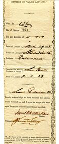
certificate, March 29th 1888
From the THE LAND ACT 1884.-REGULATIONS: "Any person duly licensed under section 93 of The Land Act 1884 to cut and take away any live or dead timber on Crown lands, and any person specially licensed in that behalf by the Governor in Council, may at all times enter upon the said land and therefrom cut and take away live or dead timber. "The Richardson family was one of the very early settler families to establish themselves in the Orbost district. Samuel Richardson was builder of the Paddle Steamer Curlip.A white paper licence certificate No. 182 made out to Samuel Richardson & Son for the purpose of a Saw Mill. It was to cost ten pounds per annum. Print is black and details are hand-written.richardson-samuel certificate-lands-sawmill -
 Orbost & District Historical Society
black / white photograph, January 1934
Damage estimated at £500,000 was caused by the 1934 floods in the Orbost district. This 1934 flood was devastating, destroying a section of the 1922 Orbost bridge, wrecking fences, bridges and roads, dumping silt and debris on the rich river flats and drowning cattle. This photograph shows Lochiel Lagoon ( the billabong) in the foreground. Ten minutes after this photograph was taken, the centre span of the Orbost Bridge was washed away.This item is a pictorial record of the 1934 floods, a significant part of Orbost's history.A black / white photograph of swirling floodwaters with township in the background.orbost-floods-1934 natural-disasters-floods -
 Eltham District Historical Society Inc
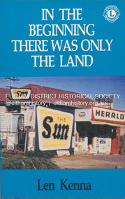
Book, Len Kenna, In the beginning there was only the land, 1988
A book, published as part of the Australian Bicentenary Celebrations on the history of the suburb of Bundoora. ... Includes photographs, maps and index. Local history of the outer Melbourne suburb of Bundoora, from the original Wurundjeri people through to its development as a thriving suburb in the 1980s ; section entitled "The Aborigines" (pp.14-21) discusses the traditional way of life of the Wurundjeri people prior to European settlement.bundoora, bundoora hall, hospitals, jane mckimmie, janefield, janefield church, john mckimmie, la trobe university, marvellous melbourne, mont park, mont park psychiatric hospital, plenty river, william shillinglaw, wurundjeri, yan yean reservoir -
 Greensborough Historical Society
Article, Anne Paul, History of Maroondah Aqueduct Pipe Bridge over the Plenty River at Greensborough, by Anne Paul, 2012_03
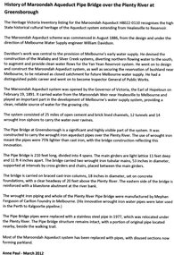
The Maroondah Aqueduct pipe bridge, opened in 1891, was an important part of the system carrying water from the Maroondah Reservoir near Healesville to Melbourne. Most of the original system has been replaced by stainless steel pipes, the Greensborough section now running under the Plenty River since 1977. The original pipe bridge can still be seen over the Plenty River at Greensborough.2 p. typescriptaqueduct pipe bridge greensborough, maroondah aqueduct, melbourne water supply, anne paul -
 Lorne Historical Society
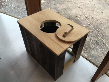
Functional object - Thunderbox, Circa 1930’s
The Great Ocean Road was built by World War 1 returned servicemen. Tolls were collected as sections of the road were completed. The first toll house was at Grassy Creek. It operated from 1922 to 1932 when it was moved to The Springs at Cathedral Rock about 5 km east of Lorne. The thunderbox is believed to have been used here at sometime between 1932 and 1936This is a rare archeological find. Items n this location are often damaged by the action of the sea and salt air. It is intimately associated with the early years of the development of the Great Ocean Road and the daily life of the workers. It is a typical example of the type of toilet used at the time. This reclaimed timber thunder box is enclosed on three sides. There is a circular hole on the top with a wooden handled lid attached by a chain. Inside is a steel can.great ocean road construction, returned sevicemen world war 1, great ocean road toll houses, toilet -
 Ararat & District Historical Society (operating the Langi Morgala Museum)
Photograph
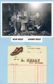
L. Kelly Boot Repairer was located at 308 Barkly Street, Ararat, now the current site of Ararat Tyre Power (272 Barkly Street, Ararat). Old site in the early 1940s was Mr H. McMillan Garage for motor repairs. The boot repair section was rented by Laurie Kelly, then 308 Barkly Street. After World War 2 it became home of PMGBlack and white photograph of two men wearing aprons and standing at a work bench with tools. A docket featuring a shoe and a business address for L. Kelly Boot Repairer is beneath the photo.Ron Kelly, Laurie Kelly -
 Warrnambool and District Historical Society Inc.
Document, Newspaper: Warrnambool Standard Christmas 1989, 1989
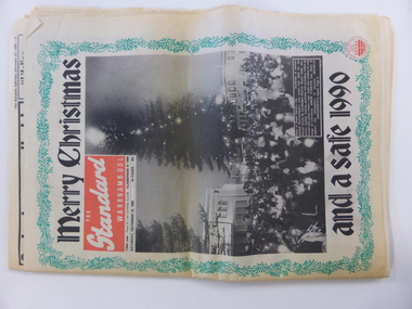
This newspaper holds a collection of usual articles from local and national news,sports news to letters to the editor, advertisements and a supplement on activities for the holiday period. It contains the local advertisements for houses. The Holiday Guide section has articles on the Moscow Circus, Robert Ullmann, Lake Pertobe playground, local national parks, The film Quigley Down Under and points of interest along the coast. An interesting walk back through time and an interesting record of events and advertisements for businesses at the time.Front page has green holly border with photograph of Carols by Candlelight on the Civic Green. Banner headlines are in black.Back cover has a Christmas poem printed in black on pink background. Green holly border.44 pagesSaturday December 23 1989.warrnambool,, warrnambool standard, warrnambool standard december 1989 -
 Eltham District Historical Society Inc
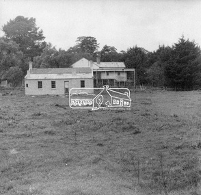
Negative - Photograph, George W. Bell, Re-erection of Shillinglaw Cottage, c.1966
View looking up from near the Eltham Railway Trestle Bridge over what was to become the Eltham Common at Shillinglaw Cottage in its new location prior to restoration. The former Gahan house, seen in the background was demolished in 1968 when the Main Road was duplicated in this section. The Eltham Common was taken over with the construction of the new Eltham Library which opened in 1994.Shillinglaw Cottage is itself historically, aesthetically and socially significant to the Shire of Nillumbik and is registered on the Victorian Heritage Database. This photo forms part of a collection of photographs gathered by the Shire of Eltham for their centenary project book, "Pioneers and Painters: 100 years of the Shire of Eltham" by Alan Marshall (1971). The collection of over 500 images is held in partnership between Eltham District Historical Society and Yarra Plenty Regional Library (Eltham Library) and is now formally known as 'The Shire of Eltham Pioneers Photograph Collection.' It is significant in being the first community sourced collection representing the places and people of the Shire's first one hundred years.Digital image 4 x 5 inch B&W Negsepp, shire of eltham pioneers photograph collection, eltham, shillinglaw cottage, eltham shire office, gahan house, derril, gahan, george w. bell collection, houses, main road -
 Wannon Water
Brochure, Cross' patent joint no.14175, circa 1915
Samuel Cross worked for the Hamilton Waterworks Trust and his invention relates to a box joint in two sections and is particularly useful for repairing a pipe containing fluid under either high or low pressure in which a leak, blow out, or burst occurs. Samuel Cross' invention is mentioned in the minutes of the Hamilton Waterworks Trust, copied pages can be found in the supplementary files. Cross' invention helped to prevent water loss whilst a pipe was being repaired. Hamilton Waterworks Trust was an early predecessor to Glenelg Water which later merged with Portland Coast Water and South West Water to form Wannon Water. The patent is significant because the invention was revolutionary for the early Victorian 20th century engineering, and it is still being used today.A3 sheet, printed on both sides, folded into A4, printed in black and white, contains 4 photographs.water pipes, water supply, engineering, samuel cross, hamilton -
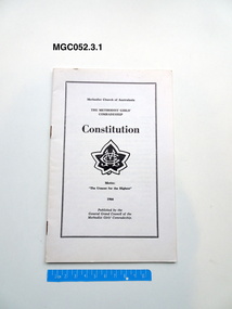 Uniting Church Archives - Synod of Victoria
Booklet - Constitution, General Grand Council of the Methodist Girls' Comradeship, Methodist Girls' Comradeship Constitution, 1966
MGCE052.3.1 and MGC052.3.2: White paper booklet with the emblem of the MGC on the front.non-fictionmethodist girls' comardeship, methodist girls' comradeship rays' section, costitutions, methodist church of australasia, youth clubs, methodist youth of australasia -
 Unions Ballarat
Don Chipp: The third man (Don Woodward Collection), Larkin, John et al, 1978
Don Chipp was a former Liberal Party politician. He was the founder of the Australian Democrats in 1977 and gained the balance of power in the Senate. The foreword is written by John Gorton (former Liberal Prime Minister) and an afterword by RJ Hawke (former ALP Prime Minister). Section titles: 1. In the beginning 2. Inside Canberra: Menzies to Fraser 3. Moving on 4. Present shock Biographical and political interest (Australia).Book; 254 pages. Dust jacket: grey background; colour artistic representation of Don Chipp; red lettering; authors' names and title. Cover: red background; gold lettering; authors' names and titles on spine.btlc, ballarat trades hall, ballarat trades and labour council, chipp, don, politics and government, senate - australia, liberal party australia, senators, australian democrats, parliament, menzies, robert, fraser, malcolm, hawke, rj, alp, australian labor party, prime minister - australia, biography, autobiography -
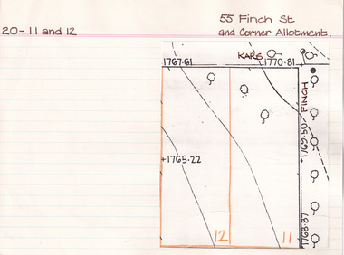 The Beechworth Burke Museum Research Collection
Card (Series) - Index Card, George Tibbits, 55 Finch Street, Beechworth (and corner allotment), 1976
George Tibbits, University of Melbourne. Faculty of Architecture, Building and Town & Regional PlanningIndex system that support the research for Beechworth : historical reconstruction / [by] George Tibbits ... [et al]Arranged by street names of BeechworthEach index card includes: street name and number of property, image of property, allotment and section number, property owners and dates of ownership, description of the property according to rate records, property floor plan with dimensions.beechworth, george tibbitsbeechworth, george tibbits -
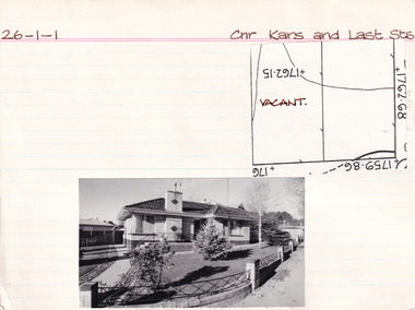 The Beechworth Burke Museum Research Collection
Card (Series) - Index Card, George Tibbits, Cnr Kars & Last Streets, Beechworth, 1976
George Tibbits, University of Melbourne. Faculty of Architecture, Building and Town & Regional PlanningIndex system that support the research for Beechworth : historical reconstruction / [by] George Tibbits ... [et al]Arranged by street names of BeechworthEach index card includes: street name and number of property, image of property, allotment and section number, property owners and dates of ownership, description of the property according to rate records, property floor plan with dimensions.beechworth, george tibbitsbeechworth, george tibbits -
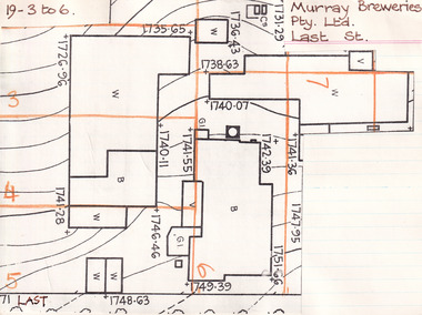 The Beechworth Burke Museum Research Collection
Card (Series) - Index Card, George Tibbits, William Street, Beechworth, 1976
George Tibbits, University of Melbourne. Faculty of Architecture, Building and Town & Regional PlanningIndex system that support the research for Beechworth : historical reconstruction / [by] George Tibbits ... [et al]Arranged by street names of BeechworthEach index card includes: street name and number of property, image of property, allotment and section number, property owners and dates of ownership, description of the property according to rate records, property floor plan with dimensions.beechworth, george tibbitsbeechworth, george tibbits -
 The Beechworth Burke Museum Research Collection
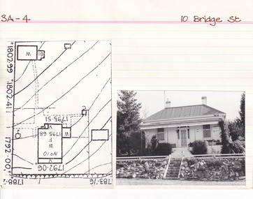
Card (Series) - Index Card, George Tibbits, 10 Bridge Street, Beechworth, 1976
George Tibbits, University of Melbourne. Faculty of Architecture, Building and Town & Regional PlanningIndex system that support the research for Beechworth : historical reconstruction / [by] George Tibbits ... [et al]Arranged by street names of BeechworthEach index card includes: street name and number of property, image of property, allotment and section number, property owners and dates of ownership, description of the property according to rate records, property floor plan with dimensions.beechworth, george tibbitsbeechworth, george tibbits -
 The Beechworth Burke Museum Research Collection
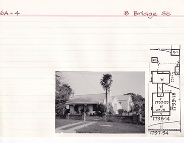
Card (Series) - Index Card, George Tibbits, 18 Bridge Street, Beechworth, 1976
George Tibbits, University of Melbourne. Faculty of Architecture, Building and Town & Regional PlanningIndex system that support the research for Beechworth : historical reconstruction / [by] George Tibbits ... [et al]Arranged by street names of BeechworthEach index card includes: street name and number of property, image of property, allotment and section number, property owners and dates of ownership, description of the property according to rate records, property floor plan with dimensions.beechworth, george tibbitsbeechworth, george tibbits -
 The Beechworth Burke Museum Research Collection
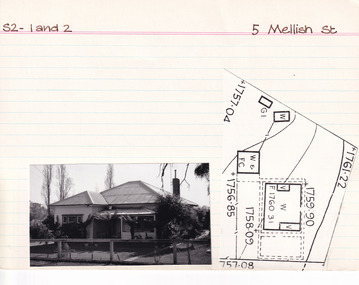
Card (Series) - Index Card, George Tibbits, 5 Mellish Street, Beechworth, 1976
George Tibbits, University of Melbourne. Faculty of Architecture, Building and Town & Regional PlanningIndex system that support the research for Beechworth : historical reconstruction / [by] George Tibbits ... [et al]Arranged by street names of BeechworthEach index card includes: street name and number of property, image of property, allotment and section number, property owners and dates of ownership, description of the property according to rate records, property floor plan with dimensions.beechworth, george tibbitsbeechworth, george tibbits -
 The Beechworth Burke Museum Research Collection
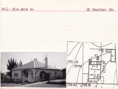
Card (Series) - Index Card, George Tibbits, 15 Mellish Street, Beechworth, 1976
George Tibbits, University of Melbourne. Faculty of Architecture, Building and Town & Regional PlanningIndex system that support the research for Beechworth : historical reconstruction / [by] George Tibbits ... [et al]Arranged by street names of BeechworthEach index card includes: street name and number of property, image of property, allotment and section number, property owners and dates of ownership, description of the property according to rate records, property floor plan with dimensions.beechworth, george tibbitsbeechworth, george tibbits -
 Melbourne Tram Museum
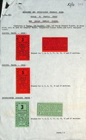
Document - Notice to Traffic Staff, Melbourne & Metropolitan Tramways Board (MMTB), "New Design of Prepaid Tickets", Dec. 1965
Notice to traffic staff C881, dated 1/12/1965 about the introduction of a new design of prepaid tram tickets. Samples provided for Hospital Travel for both Adults and Children, incapacitated soldiers, and PMG (Post Master General) employees. Gives details of the sections printed for and that old tickets are not to be accepted. The new style of tickets were to commence on 5/12/1965.Yields information about the style of prepaid tickets introduced during Dec. 1965.Notice - printed on both a sheet of quarto and foolscap paper with actual sample tickets glued on.Has in ink in top right hand corner "D/O" and "303"tramways, tickets, prepaid tickets, pmg -
 Hymettus Cottage & Garden Ballarat
Medal
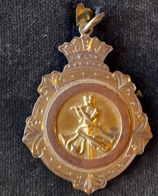
Brass band instrumental music competitions were enthusiastically followed in Australia in the early twentieth century. Ballarat was a leading centre for these musical competitions and Michael Taffe played cornet and flugelhorn with several local brass bands. He was Australian Junior Cornet solo Champion in 1920 and won the open section of the instrumentals at the VRI competitions held in the ballroom at Flinders Street Station in 1924. michael taffe, victorian railways institute, cornet solo, flinders street station ballroom -
 Melbourne Tram Museum
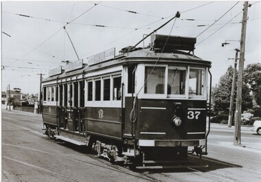
Photograph - Black and White - VR Tram 37 - Elwood Depot, Victorian Railways (VR)
Photograph of tram 37 shows the Victorian Railways colour scheme, the oil lamp that was provided on VR trams on the St Kilda to Brighton, Electric Street Railway. Has 3 Robur Tea roof advertisements. The tram is shunting at the depot or waiting to run to St Kilda Railway Station, possibly after the closure of section south of the depot. Original Victorian Railways Photograph. Yields information about the location, the streetscape and the trams in use at the time. Black and white photograph of Victorian Railways tram 37 outside Elwood Depot in St Kilda St, possibly in the early 1950s. Original Victorian Railways Photograph.tramways, trams, vr trams, elwood tram depot, st kilda st, tram 37, victorian railways -
 National Vietnam Veterans Museum (NVVM)
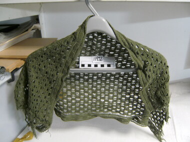
Equipment - Sweat rag
General purpose open weave cotton scrim as issued in Vietnam war. Used by National Serviceman, Lance Corporal B A Rosenthal, 3rd Battalion, The Royal Australian Regiment 1967-8, Mentioned in Despatches for his command and control during a section ambush in which he was wounded. Unit Citation for Gallantry for his involvement in the Battle of Fire Support Bases Coral and Balmoral.Green crochet cotton scarf used as a sweat rag for soldiers in jungle.scarf, sweat rag, sweat cloth, army scrim, rosenthal -
 Ballarat Tramway Museum
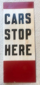
Sign, "CARS STOP HERE", 1960's
Small red band at top, white band with letters CARS STOP HERE and large red band underneath, on both sides to indicate to drivers a compulsory stop. That is, all tram to stop at the location. The same sign was used for the same purpose in Melbourne. Has three holes for screws on the upstand or folded section. See item 9570 for a "HAIL CARS HERE" version. Demonstrates the signage used by the SEC (and the MMTB) to indicate tram stops and in particular compulsory tram stops. Piece of sheet steel folded to give an upstand or method of attachment to a pole, enameled with red, white, and black paint for use at tram stops. Two copies held.trams, tramways, ballarat, secv, tram stops, furniture