Showing 10994 items matching " land"
-
 Ringwood and District Historical Society
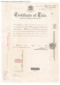
Document, Certificate of Title - W.G. Carter, Grandview Grove, Warranwood, Victoria, (later Bemboka Road) - part of Crown Section Twenty, Parish of Warrandyte, County of Evelyn - 1947
A4 copies of Landata Victoria Historical Search documents - Vol 7052 Fol 1410222. Includes Carter Family Tree property notes. William George Carter of Grandview Grove Ringwood, Nurseryman, is now the proprietor - three acres or thereabouts shown on map (12202a) - 14th March, 1947. Transfer B284834 Registered 21 September, 1961 - 1 acre shown on map (12202c) north of Plymouth Road. NOTES ON GRANDVIEW GROVE PROPERTY (Carter Family Tree extract) The Grandview Grove property was purchased by William (Bill) and Doreen Carter in 1947 as three acres of uncleared bushland. They had a 2 bedroom fibro-cement house built on the land which they informally called "Willoreen". With Doreen looking after sons Peter (born in 1940) and Robin (born in 1950), Bill worked locally at Croydon Dairy. The family spent much of their spare time clearing the land, where Bill then grew and sold fruit, flowers and berries, particularly strawberries, as a hobby and to supplement their income. Bill continued to do so while Peter and Robin were growing up, and after Doreen died in 1958. In 1961 Bill sold one of the three acres to one of his seven sisters, Grace, who lived in Kew but later moved to Rosebud and sold the land without ever building on it. During the 1960s, Grandview Grove was renamed Bemboka Road. After retiring as a milkman, Bill moved to Rosebud, Vic, and in 1977, sold the property to the Anglican Church, who were looking to invest in the site in anticipation of proposed future residential development in the area. As nearby properties were subdivided during the 1980s, the house, which the Church had initially utilised as low-cost family accommodation, was modified internaly to become a church/Sunday school. By the early 2000s, construction of a contemporary-design church and carparking area between the house and street alignment had been completed but the house remained as a detatched meeting room until falling into disrepair and was eventually demolished around 2010. -
 Eltham District Historical Society Inc
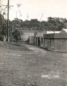
Photograph, N. J. Tillings Timber Factory, 15 June, 1975, 15/06/1975
N. J. Tillings Timber Factory was part of the Brougham Street, Light industrial area, Eltham. Brick bulidings includes signage: Wakefield Pr... (printer?) No 17 Building C. This is one of 7 B/W 8x10 inch photos with notes on obverse by Dick Crichton. Accompanying letter from Florence Chrichton 2013 : "Originally sent to Shire of Eltham Engineer, Mr. McDonald. [These photographs were part of their campaign to the Shire of Eltham in 1975] claiming that the zoning regulations were being breached by the occupants of various factories in the nearby light industrial zone [Brougham Street, Eltham] - to the detriment of those living in adjoining residential zones, and that, despite .. earlier objections and complaints, nothing was done about it."1 black and white photograph printed with white borderInscribed on back: "Weekend photograph of factories in Brougham Street surrounded by by residential zone. On weekdays cars surround premises - these have been built approx. two years - where is the landscaping? * Undeveloped light industrial land. Careful planning needed for future. Being on high elevations backs of future buildings will be seen from Main Road Eltham and future Art Centre complex. Also Bolton Street becoming heavily used arterial road. Off street parking facilities most important." . The front of the photo has pen marks indicating points of interest.industrial estate, brougham street, eltham -
 Uniting Church Archives - Synod of Victoria
Plaque, 1989
Wood and metal box with 2 doors with a plaque inserted. "PLAQUE OF APPRECIATION. Deaconess Cath Ritchie. The Uniting Church of Australia Seoul, Korea October 2, 1989. We give thanks for the precious work of missionary who for the salvation of our Korean people came to this land with the love of Christ and through the tears and sweat gave us the good news of the gospel. By these words the Presbyterian Church of Korea at its 74th General Assembly records this intent as we offer a service of praise to God commemorating one hundred years of Korea-Australia mission. (Rev.) Meng Syul Park, Moderator Presbyterian Church of Korea."deaconess cath ritchie, presbyterian church of korea -
![The Township of Walhalla / [by] Nicholas Caire, circa 1876](/media/collectors/550653872162f11fb04854aa/items/57825a89d0cdd1176ce3295a/item-media/57825aefd0cdd1176ce34515/item-fit-380x285.jpg) Kew Historical Society Inc
Kew Historical Society IncPhotograph, Anglo-Australasian Photographic Company, The Township of Walhalla, c. 1876
Nicholas Caire was born on Guernsey in the Channel Islands in 1837. He arrived in Adelaide with his parents in about 1860. In 1867, following photographic journeys in Gippsland, he opened a studio in Adelaide. From 1870 to 1876 he lived and worked in Talbot in Central Victoria. In 1876 he purchased T. F. Chuck's studios in the Royal Arcade Melbourne. In 1885, following the introduction of dry plate photography, he began a series of landscape series, which were commercially successful. As a photographer, he travelled extensively through Victoria, photographing places few of his contemporaries had previously seen. He died in 1918. Reference: Jack Cato, 'Caire, Nicholas John (1837–1918)', Australian Dictionary of Biography.An original, rare photograph from the series 'Views of Victoria: General Series' by the photographer, Nicholas Caire (1837-1918). The series of 60 photographs that comprise the series was issued c. 1876 and reinforced a neo-Romantic view of the Australian landscape to which a growing nationalist movement would respond. Nicholas Caire was active as a photographer in Australia from 1858 until his death in 1918. His vision of the Australian bush and pioneer life had a counterpart in the works of Henry Lawson and other nationalist poets, authors and painters.‘The Township of Walhalla’ : Views of Victoria (General Series) No.37 : Albumen silver photograph | Photo on card with Title and Description on reverse | Mounted 24 x 30 cm; Photo 12 x 17 cm.On Reverse: ‘This romantic Township is situated near Stringer’s Creek in Gipps Land, not far from the celebrated Baw-Baw Mountains. The Long Tunnel Gold Claim has proved a great source of wealth to this small out-of-the-way place, yielding sometimes between 2,000 and 3,000 ounces of gold per month. The population, which is mostly a mining one, reaches nearly 2,000 inhabitants, and are scattered about among the creeks and gullies of the neighbourhood. Until recently, the road traffic was limited to pack-horses, in consequence of the precipitous hills which surround the Town.‘nicholas caire (1837-1918), walhalla, landscape photography -
 Eltham District Historical Society Inc
Photograph - Digital Photograph, Jim Connor, Edendale Farm Homestead, 11 December 2014
Edendale Farm is Nillumbik Shire Council's environment centre situated in Gastons Road, Eltham between the railway and the Diamond Creek. The homestead on the property was built in 1896 and is of historical significance, being the subject of a Heritage Overlay under the Nillumbik Planning Scheme. The Edendale property was originally part of an extensive land purchase in 1852 from the Crown by pioneer Eltham farmer Henry Stooke. He initially purchased 51 acres and later expanded his holdings by purchasing another three adjacent Crown allotments extending northerly from Josiah Holloway's Little Eltham subdivision. Despite clearing the land, Stooke did not build on this property, choosing to live on his property "Rosehill" at Lower Plenty. In 1896 Thomas Cool, Club Manager of the Victoria Coffee Palace in Melbourne purchased 7 acres of the original Stooke land and built the house now known as Edendale. Cool did not farm the land, instead using it as a gentleman’s residence, retiring to Eltham at weekends. In 1918 he purchased an additional 7 acres but in 1919 he sold the property. Later owners included J.W. Cox, the Gaston family and D. Mummery. In the 1980s the Eltham Shire Council purchased the site for use as a Council depot, but this use did not proceed. Subsequently, it was used as the Council pound. The Edendale Farm Pet Education and Retention Centre was established in the summer of 1988/1989 and was set up to replace the existing dog kennels with a high standard pet retention centre. The design style of the building was established to compliment the features of the existing house. It was equipped with 10 retention pens, a veterinary room and a pet education area where school children and other interested parties learnt about pet care procedures. It was later developed into a community farm and was run by an advisory committee and in 2000 it became an Environment Centre. In early 2006 an advisory committee was established for the development of a master plan for future development at Edendale Farm. The committee included Russell Yeoman, a former long-time shire planner and founding member of the Eltham District Historical Society. At the time of filming the Master Plan and future for Edendale was about continuing to develop Edendale as a centre of environment learning and looking at expanding displays and school program, running a lot more of life-long learning and workshops around sustainable living.jim connor collection, edendale community farm, edendale farm, eltham, gastons road -
 Eltham District Historical Society Inc
Document - Folder, Dendy, 2012
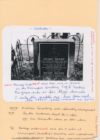
Henry Dendy (1800-1881) was an early settler of Eltham where he operated a flour mill. He donated land for the construction of St Margaret's Anglican Church. EDHS Newsletter No. 168 May 2006 Dendy is best known as the founder of Brighton, but it is not so well known that years later he lived at Eltham for far longer than he lived at Brighton. In 1840 while still in England he bought eight square miles of unspecified land in the Port Phillip District. This entitled him to bring a number of other persons to the colony and in 1841 he arrived at Williamstown in the "York" with his family and 139 others. He took up his land entitlement at what is now Brighton and most of the emigrants settled there. He encountered financial problems and lost his interest in the estate in 1844. He left Brighton in 1847. He successively but not always successfully became a brewer at Geelong, a sheep farmer at Christmas Hills and Upper Moira, a flour miller at Eltham; a sheep farmer again at Werribee and finally a copper miner at Walhalla. Dendy came to Eltham in 1856 after having spent a year in England. The total of the two parcels of land that he bought was about 5 acres (2 hectares) and it included the steam flour mill. . He became prominent in local affairs, serving for a time on the Eltham District Road Board, including one year as President. Dendy' s wife Sarah died at Eltham in 1860 and also in that year he was appointed chairman of a committee to establish a Church of England in Eltham. He donated one of his Pitt Street lots for this purpose and St Margaret's was opened in 1861. In 1867 Dendy sold his mill to W. F. Ford and moved to Werribee and then Walhalla where he remained until his death. He is buried in the Walhalla cemetery. No sign of Dendy's house or mill remain on the Community Centre site but some of the old trees running along the former boundary through the centre of the site could well have been planted in Dendy' s time. Much of this information was obtained from the book ''Henry Dendy and his Emigrants" by L.A. Schumer (Sallas Books 1975). The Society has an extensive file of Dendy information, much of it provided by the late Leslie Schumer. Manilla folder of information. Includes Folder 88 from Harry Gilham Collection which includes EDHS tour notes of St Margaret's Anglican Church, Eltham, 2012, copy of newspaper article, Diamond Valley News, December 15, 1981, copy of newspaper article, The Advertiser, September 2, 1932, photocopy of photograph of graves at Walhalla Cemetery and Warringal Cemetery, photocopies, 6 pages from an unsourced book. henry dendy, st margaret's anglican church, catholic section, eltham cemetery, harry gilham collection, sarah dendy, walhalla cemetery -
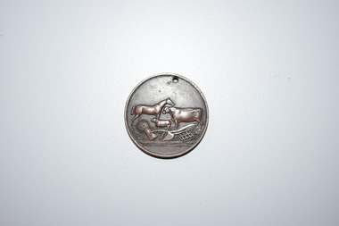 Warrnambool and District Historical Society Inc.
Medal, Stokes and Martin, Rutledge Brothers, 1877
This medal was made by Stokes and Martin. Thomas Stokes established a medal-making business in Melbourne in 1856 and from 1867 to 1893 he had a partner, George Frederick Martin. In 1962 the Stokes business became a public company and operates today in Melbourne. The medal was awarded at the Annual Show of the Villiers and Heytesbury Agricultural Association in 1877. One of the earliest agricultural associations in Victoria, the V.& H.A.A., the forerunner of the Warrnambool Agricultural Society, was established in 1854 and the first Warrnambool Show was held in 1855 at the first Royal Archer Hotel in Koroit Street. The Warrnambool Agricultural Show is still held annually. The medal, first prize for the best horse hay rake, was awarded in 1877 to the brothers, Thomas and William Rutledge, sons of Eliza and William Rutledge. The latter was a pioneer settler who came to the Warrnambool/Port Fairy district as the purchaser of the Special Survey, Farnham Park in 1841. His land stretched from Tower Hill to Dennington. William Rutledge Senior was a pioneer breeder of a Lincoln sheep stud, the owner of a mercantile business in Port Fairy, a member of the Legislative Council of Victoria and the pioneer developer of farming land around Tower Hill. His son Thomas (1846-1918) was a Warrnambool Shire Councillor who farmed in the Farnham Survey, living at Werronggurt . He went to the Geelong area at the end of the 19th century. His brother William (1849-1935) also farmed in the Farnham Survey, living at Farnham Park, He later lived at Airlie in Henna Street, Warrnambool and Sherwood on the Hopkins River and had land in the Otway Ranges. He later went to New Zealand.This medal is of considerable significance because of its age and its association with Thomas and William Rutledge and with the Villiers and Heytesbury Agricultural Association.This is a bronze medal with an image of agricultural implements, agricultural produce and farm animals on one side and etched printing on the other side. There is also printing around the edge of the medal. The medal has a small hole at the top for attaching the medal to a cord. Villiers & Heytesbury Agricultural Association 1st Prize awarded to Rutledge Bro. for Horse Hay Rake Annual Show Warrnambool 10 Oct. 1877 Stokes & Martin Melbourne thomas and william rutledge, farnham special survey, villiers and heytesbury agricultural association, warrnambool agricultural society, history of warrnambool -
 Eltham District Historical Society Inc
Artwork, other - Painting, Peter Glass, Summer Landscape, Kangaroo Ground, 1968
Arthur William Glass known as Peter was born August 28, 1917. During the 1930s, Peter Glass and a young Graeme Bell were studying painting under Max Meldrum. Graeme Bell at that time was undecided whether to devote his life to music or painting. In 1938, inspired by what they had seen at 'Montsalvat', Peter Glass along with Graeme and Roger Bell (whose names were to become internationally known as the leaders of Australia's most famous jazz band) agreed to purchase land at Eltham to build themselves a mud brick house. For some time, Eltham had been their chosen place for painting and sketching, but it was not until they visited the 'Jorgensen Colony', as it was then known, and saw the possibilities of building in earth, that they decided to establish a permanent base in Eltham. In July, the three of them bought a few acres of land at the top of John Street and started making mud bricks for a proposed sixty square sized house. Following the Second World War, Peter Glass returned in 1946 to live permanently in Eltham. He resumed work on building of the adobe house which he had commenced before the war. During some years spent in England and France he married a French girl and on returning to Eltham he built another adobe house in which he lived with his wife, Cecile Madeleine, and two children, Julian and Marie-Luce on land adjoining the original house. Peter Glass died in December 1997 aged 80, his wife Cecile in 2006, aged 79. They are memorialised in Eltham Cemetery. Much of the inspiration for his landscape painting comes from the Eltham bush and the Yarra flowing through it.oil on chipboard 33 x 40.5 x 1.0 cm Signed 'Peter Glass in red paint lower right of centre Evidence of some paint rub-off at edges from previous frame mounting (frame removed).Reverse side painted in pale yellow cream and inscribed: 'Summer Landscape - 1968 Kangaroo Ground' in black paint1968, arthur william glass, artwork, kangaroo ground, paintings, peter glass -
 Eltham District Historical Society Inc
Photograph, Stokes family with horse and sled, Nyora Road, Eltham, c.1950, 1950c
Taken from outside the family home on the southest corner of the intersection of Nyora Road and Pitt Street with Eucalyptus Road, looking northeast across the Stokes Orchard Frank Stokes with children, Dorothy (left), Beryl and David Frank Stokes first traveled to the district by train in 1944 to find land with the intention to establish an orchard. By chance he met Arthur Bird of Bird Orchard (bounded by Pitt Street, Eucalyptus Road and Wattle Grove) and they got talking over their common interest. Arthur put Frank up for the night and pointed out the land, part of Crown Allotment 15, Section 5, Parish of Nillumbik (CA15) somewhat diagonally opposite Bird Orchard. Frank bought the land and for the next two years would travel by train from Melbourne to Eltham every weekend establishing Stokes Orchard and building a home for his family, which they eventually moved into in 1946. In the mid 1970s the Shire of Eltham divided the orchard up into numerous rate-able parcel lots, which became affordable for Frank. As a consequence Stokes Orchard was turned into a housing development by Macquarie Builders and marketed as the Stokes Orchard Estate in two stages; Stage 1 encompassing Scarlet Ash Court, Ironbark Close and Peppermint Grove bounded by Nyora and Eucalyptus roads c.1976 and Stage 2 encompassing Stokes Place, Orchard Way, The Crest and The Lookout bound by Nyora and Diosma roads c.1979. The development of Orchard Way, The Crest and The Lookout did not proceed as planned due to the lack of the sewer along Diosma Road and so many of the proposed lots were incorporated into five-acre parcels instead.Representative of the orchard growing areas of ElthamDigital file only - Digitised by EDHS from a scrapbook (containing commercially printed photos of digital scans) on loan from Beryl Bradbury (nee Stokes), daughter of Frank Stokes.1950, beryl bradbury (nee stokes), beryl bradbury (nee stokes) collection, david stokes, dorothy stokes, eltham, frank stokes, horse, nyora road, sled, stokes orchard -
 Eltham District Historical Society Inc
Photograph, Looking south towards Nyora Road, Eltham, 1977, 1977
Viewed from near the end of Stokes Place where the linear reserve now runs between 8 and 9 Stokes Place just visible through trees in foreground, 24 Nyora with red roof is the first house in middle of view. Frank Stokes first traveled to the district by train in 1944 to find land with the intention to establish an orchard. By chance he met Arthur Bird of Bird Orchard (bounded by Pitt Street, Eucalyptus Road and Wattle Grove) and they got talking over their common interest. Arthur put Frank up for the night and pointed out the land, part of Crown Allotment 15, Section 5, Parish of Nillumbik (CA15) somewhat diagonally opposite Bird Orchard. Frank bought the land and for the next two years would travel by train from Melbourne to Eltham every weekend establishing Stokes Orchard and building a home for his family, which they eventually moved into in 1946. In the mid 1970s the Shire of Eltham divided the orchard up into numerous rate-able parcel lots, which became affordable for Frank. As a consequence Stokes Orchard was turned into a housing development by Macquarie Builders and marketed as the Stokes Orchard Estate in two stages; Stage 1 encompassing Scarlet Ash Court, Ironbark Close and Peppermint Grove bounded by Nyora and Eucalyptus roads c.1976 and Stage 2 encompassing Stokes Place, Orchard Way, The Crest and The Lookout bound by Nyora and Diosma roads c.1979. The development of Orchard Way, The Crest and The Lookout did not proceed as planned due to the lack of the sewer along Diosma Road and so many of the proposed lots were incorporated into five-acre parcels instead.Housing development in Eltham as an extension to the Woodridge EstateDigital file only - Digitised by EDHS from a scrapbook (containing commercially printed photos of digital scans) on loan from Beryl Bradbury (nee Stokes), daughter of Frank Stokes.1977, beryl bradbury (nee stokes) collection, nyora road, stokes orchard estate, stokes place -
 Eltham District Historical Society Inc
Photograph, Stokes Place, Eltham, July 1977, July 1977
Viewed from near the end of Stokes Place where the linear reserve now runs between 8 and 9 Stokes Place looking slightly east of south towards Nyora Road. The new Christian Church on Nyora now the Baptist Church visible in middle view. Frank Stokes first traveled to the district by train in 1944 to find land with the intention to establish an orchard. By chance he met Arthur Bird of Bird Orchard (bounded by Pitt Street, Eucalyptus Road and Wattle Grove) and they got talking over their common interest. Arthur put Frank up for the night and pointed out the land, part of Crown Allotment 15, Section 5, Parish of Nillumbik (CA15) somewhat diagonally opposite Bird Orchard. Frank bought the land and for the next two years would travel by train from Melbourne to Eltham every weekend establishing Stokes Orchard and building a home for his family, which they eventually moved into in 1946. In the mid 1970s the Shire of Eltham divided the orchard up into numerous rate-able parcel lots, which became affordable for Frank. As a consequence Stokes Orchard was turned into a housing development by Macquarie Builders and marketed as the Stokes Orchard Estate in two stages; Stage 1 encompassing Scarlet Ash Court, Ironbark Close and Peppermint Grove bounded by Nyora and Eucalyptus roads c.1976 and Stage 2 encompassing Stokes Place, Orchard Way, The Crest and The Lookout bound by Nyora and Diosma roads c.1979. The development of Orchard Way, The Crest and The Lookout did not proceed as planned due to the lack of the sewer along Diosma Road and so many of the proposed lots were incorporated into five-acre parcels instead.Housing development in Eltham as an extension to the Woodridge EstateDigital file only - Digitised by EDHS from a scrapbook (containing commercially printed photos of digital scans) on loan from Beryl Bradbury (nee Stokes), daughter of Frank Stokes.1977-07, beryl bradbury (nee stokes) collection, eltham, eltham christian church, stokes orchard estate, stokes place -
 Ballarat Heritage Services
Photograph - Photograph - Colour, Former Lake Condah Aboriginal Mission, 17/04/2016
The Lake Condah Mission site includes bluestone ruins and a reconstructed timber building, as well as the cemetery which were part of the original settlement. With European settlement in the 1830s came conflict. Gunditjmara people fought for their land during the Eumerella wars, which lasted more than 20 years. As this conflict drew to an end in the 1860s, many Aboriginal people were displaced and the Victorian government began to develop reserves to house them. Many Aboriginal people refused to move from their ancestral land and eventually the government agreed to build a mission at Lake Condah, close to some of the eel traps and within sight of Budj Bim (Mt Eccles). The mission opened in 1867. The Mission was formally closed in 1918, and Aboriginal people were forced off the Mission, some moving to Lake Tyers. The Gunditjmara protested against the Mission’s closure and many continued to reside in the buildings until the majority of the reserve land was handed over to the Soldier Settlement Scheme in the 1940s. The mission was destroyed by the government in the 1950s in an effort to force the integration of Gunditjmara people with the general community but the Gunditjmara people continued to live in the area and protect their heritage. The mission lands were returned to the Gunditjmara in 1987. Lake Condah Mission is a place with special meaning to the Gunditjmara community - as a community meeting place, an administrative centre, a symbol of political struggle and a link to family histories. As a result the Gunditjmara community do not want open public access to this site. Key Features of Interest Ruins of stone cottages and plot remains of buildings such as the church Reconstructed dormitory building (https://www.budjbim.com.au/visit/cultural-sites/lake-condah-mission/?gclid=EAIaIQobChMIz6j36ZvF-QIV8ZhmAh2tmA3qEAAYASAAEgLxrvD_BwE, accessed 2022)Colour photographs of the former Lake Condah Aboriginal Missionlake condah, lake condah aboriginal mission, aborigines, aboriginal, gunditjmara, eumerella wars -
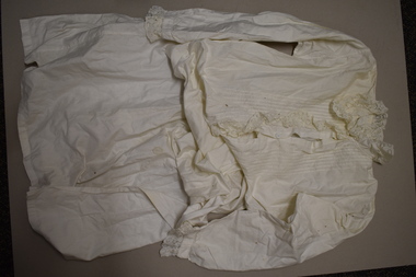 Warrnambool and District Historical Society Inc.
Nightdress, Early 20th century
This handmade woman’s nightdress comes from the Kinnear family of Allandale, Allansford. In the early 1840s William and John Allan took up a large tract of land to the east of the Hopkins River and in the late 1840s William Allan took over the Allandale section of the run and John Allan took the Tooram section. In 1906 the Kinnear family acquired a portion of Allandale which included the homestead. The nightdress came from the estates of the donor’s great aunts. This item is retained as an example of an early 20th century woman’s nightdress and it has the provenance of coming from the Kinnear family of Allandale Allansford. This is a white cotton nightdress with an opening to the waist which is enclosed with two white buttons. There is a frill of lace on one side of the opening. The white collar also has a large white frill of lace. The long sleeves are inset and have a band of lace at the wrists. There are some stains on the dress. vintage clothing, kinnear family, allansford, history of warrnambool -
 Warrnambool and District Historical Society Inc.
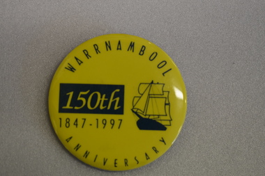
Badge, Warrnambool 150th 1847-1997
This badge was produced in 1997 as a souvenir of the 150th anniversary of the founding of Warrnambool. Warrnambool was a planned town, established in 1847 as a port to service the squatters who had taken up large tracts of land in the Warrnambool area in the 1840s.The town was surveyed by the Government surveyor William Pickering at the request of Superintendent La Trobe and the first town lots of the new town were sold in Melbourne in 1847, with some settlers arriving at the new settlement soon after.This badge is one of the many souvenirs of the 1997 celebrations in Warrnambool Circular concave metal badge with blue drawing of a sailing ship and text. There is a clip pin on the reverse.WARRNAMBOOL ANNIVERSARY 150th 1847 -1997 -
 Glen Eira Historical Society
Document - Hengar, Glen Eira Road, 356, Elsternwick
A copy of two page typed report by Hilary Bullock and Rosalind Landells, dated 18/01/1990, on the history of Hengar, a dower house built for the Langdon family in 1887/1888. The report includes an explanation of the term dower house, outlines the land sale history since 1851 and gives a brief history of the occupancy of Hengar from 1888 to 1989. The file also includes one page of undated, unattributed handwritten working notes.landells rosalind, bullock hilary, hengar, glen eira road, elsternwick, holloway j m, langdon henry j, rosecraddock, beemery park estate, lirrewa, caulfield town hall, langdon family, deanmead a, griffith alfred, langdon e e, langdon h j, langdon laura, langdon henry, langdon bessie, sadler emily amy, brenton v c, herz s, beth riukan girls’ college, happy days kindergarten, florence herald herbert, happy days child minding, manners and customs, preschools -
Glen Eira Historical Society
Document - Brewer Road, 8, Bentleigh
A copy of a two page valuation letter, dated 18/04/1966, to McKenzie and Ross Solicitors to a valuator, regarding the estate of John H Holmes at Brewer Road, 8, Bentleigh and including a description of the land and house improvements. The file also includes two pages of handwritten working notes for the purposes of the property valuation. The file also includes a two page typed document, undated, containing an inventory and valuation of furniture and effects of the property.holmes john h, brewer road, bentleigh, thomas street, bentleigh west state school, nepean highway, brick houses, furniture, furnishings -
 Eltham District Historical Society Inc
Document - Folder, Eltham Town Focus Group, 1996-1997
Documents relating to a focus group brought together by the Shire of Nillumbik Chairman of Commissioners in 1996 to provide advise on the best long term use for the buildings and land situated between the former Eltham Shire Offices and Country Fire Authority buildings. These buildings are known as the Eltham War Memorial buildings located at 903-907 Main Road, Eltham. In May 2020, the Heritage Council Victoria did not recommend the site for inclusion in the Victorian Heritage Register. 11 pagesharry gilham collection, consultation, planning, eltham, eltham war memorial, eltham war memorial buildings, commissioners -
Greensborough Historical Society
Article, Journal, Rebecca Le Get et al, More than just 'Peaceful and Picturesque', by Rebecca Le Get, 2018_06
Copy of article from Victorian Historical Journal (Issue 289, Vol.89, No.1, June 2018). The article "More than just 'Peaceful and Picturesque: How Tuberculosis control measures have preserved ecologically significant land in Melbourne', by Rebecca Le Get, looks at nature conservation reserves and the re-use of properties including the former Macleod, Gresswell and Janefield tuberculosis hospitals. Includes covering email from Rebecca to GHS.8 pages, scanned from Journal, covering email.janefield, macleod, gresswell watsonia -
 Warrnambool and District Historical Society Inc.
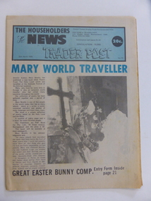
Document, Newspaper Trader Post, 20th March 1980
This magazine contains a number of small news items with the front cover story relates to Mary Betello and her poetry book on The Holy Land. Others relate to local Rotary club , theatre group, Council news and local district news. There are display advertisements listing such businesses as Ron Jessen Fabric, Owen's of Warrnambool, Crazy Dave's Lighting, Bob Sloan Butchers Rainbow Health Foods, Jetaime B & P Hoy Wholesale.A good collection of businesses from around the 1980's in Warrnambool. Small newsprint document with blue headline and blue banner at top of page with black text. There is a photograph and accompanying story on front page. Back page has blue outline on page with white print. 40 pages.District traders Buying Guide . The news & Trader Post 145 Kepler Street Warrnambool. Ph 055 621055warrnambool,the householders news and trader post, -
Federation University Historical Collection
Magazine - Booklet, Ballarat School of Mines Students' Magazine, 1939, 1939
School Council, Members of Staff, List of Full Course Students 1939, Full Course Commercial Students, S.M.B. Magazine Committee 1939, Editorial, Personal Column, Obituary - Frank Ponsonby, The Old School, The Railway Workshops, The S.M.B. Literary Society, Papua: Land of Contrasts, Old Boys' Association, Snapshots in Berlin, Fumes from the Lab, Arts & Crafts Gossip, Sport, Commercial Notes, The Junior Techs, Junior Techs SportsBlue, yellow and green covered magazine with black and green font. 70 pages including advertisements.ballarat school of mines, magazine, r. mchutchison, e. gribble, m. coward, n. rigney, o. raisbeck, g. myers, f. malseed, e. fitzgerald, m. linklater, j. wilkinson, m. dolan, j. woolcock, b. martin, g. downing, h. j. hassell, n. tatlock, a. wilson, h. trevenan, w. hender, dr. j. r. pound, a. r. gordon, mr procter, a. helm, r. desnoy, frank ponsonby, g. t. myers, h. christensen, enid johnston, k. h. wilkie, isobel boustead, eric j. gashler, violet d'angri, m. hayes, marian peirce, mr hillman, k. gingell, g. crouch, r. menhennett, j. menhennett, mr cornell, e. mann, a. vaughan, d. jelbart, a. moorhouse, d. gilmore, p. richards, j. nott, r. monteith, j. martin, f. jelbart, k. waller, a. gilpin, b. robinson, d. coad, m. dalla, u. kersey, j. cooper, p. coombs, l. stapleton, u. chisholm, l. peoples, l. stephens, j. hall, h. patterson, a. brown, v. evans, j. hallidale, c. clogan, d. ditchfield, j. daniel, e. theobald, g. james, j. unsworth, helen stichnoth, w. rowe, winsome hender, c. w. rowe, j. hosie, e. stephens, i. mclachlan, r. stoneman, m. gleeson, k. stoneman, h. tonkin, f. harland, r. bulluss, t. davies, r. gladman, m. thomas, e. salter, d. mcgregor, a. spence, g. taylor, j. pyke, r. allisey, i. clow, r. p. flower, l. taylor, b. neale, j. norman, f. p. manning, paul manning -
 Lake Bolac & District Historical Society
Black and white photograph, Local ladies working at the Flax Mill
Local ladies who worked at the Lake Bolac Flax Mill before the Land Army girls were sent in to take over. Back from left: Mrs Louis Park, Margaret Veale (Mortlake), Kath Bassett, Doris Barnes, Doris Brooks, Jean Murphy, Emily McInnes, Margaret Kinnersley. Front: Marion Witham, Myrtle Gale, Mrs Barnes, Mrs Amy Robertson, Marjorie Graham, Alice Veale (Mortlake).lake bolac, flax mill, land army -
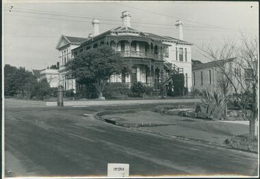
 Uniting Church Archives - Synod of Victoria
Photograph, undated
Otira was designed and built in 1887 by architect Mr Crouch, first Secretary of the Institute of Architects for Mr Henry Berry, founder of a successful wholesale grocery business. The house was acquired by the Methodist Church in 1923 for use as a home missionary training college. The house is of faced stone on a bluestone foundation. The large front door is surrounded by lead light windows surmounted by a fan light. The land on which the house stands has now been subdivided.B & W gloss photograph mounted on card of the rear of Otira, the Home Missionary Training College located at 73 Walpole Street Kew. Otira 73 Walpole Street Kew. Home MIssionaries Training College. otira, methodist home missionary training school walpole street kew, henry berr crouch -
 Uniting Church Archives - Synod of Victoria
Photograph, undated
Otira was designed and built in 1887 by architect Mr Crouch, first Secretary of the Institute of Architects for Mr Henry Berry, founder of a successful wholesale grocery business. The house was acquired by the Methodist Church in 1923 for use as a home missionary training college. The house is of faced stone on a bluestone foundation. The large front door is surrounded by lead light windows surmounted by a fan light. The land on which the house stands has now been subdivided.B & W gloss photograph mounted on card of Otira, the Home Missionary Training College located at 73 Walpole Street Kew. The photograph was taken from the street.Otira 73 Walpole Street Kew. Home MIssionaries Training College. otira, methodist home missionary training college walpole street kew, henry berr crouch -
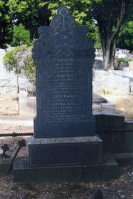 Whitehorse Historical Society Inc.
Photograph, Tombstone - Morton family
T.R.B. Morton and other investors set up the Freehold Investment Company which set out the township of Blackburn in the 1880s. The Company folded in 1892 but T.R.B. Morton, as one of the liquidators continued auctioning off the land through his company, Morton and Coghill. He was a Nunawading Shire Councillor from 1888 to 1897 and 1899 to 1923, being Shire President four times. Morton Park in Central Road, Blackburn is named after him.Coloured photograph of the Morton family tombstone on grave 1403, Church of England section, Box Hill Cemetery Morton, Thomas Richard Burrowes: 1854 - 1923 Morton, Louisa Mary: 1861 - 1937morton thomas richards burrowes, morton, louisa mary esther, tombstones, morton and coghill, auctioneers, morton park, blackburn -
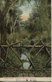 Ballarat Heritage Services
Postcard, Ballarat Botanical Gardens, c1908
"Within six years of its first land sales in 1852, founder members had challenged council over horticultural decisions and Ballarat's main thoroughfare contained fences squares, trees and flower beds. The major works that projected the Garden City image were the street plantings, parks and botanical gardens ..." Reference: Michael Taffe, Growing a garden City: Ballarat Horticultural Society 1859-2009, BHS Publishing, 2014, p. 10.This postcard shows how the botanical gardens in Ballarat, famous for being a Garden City.Coloured postcard Forest Scene, Botanical Gardens, Ballarat printed in red at bottom of card. Elaine 30-11-08 handwritten in black ink underneath.botanical gardens, ballarat, forest scene, gardens, botanical, -
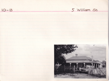 The Beechworth Burke Museum Research Collection
Card (Series) - Index Card, George Tibbits, 5 William Street, Beechworth, 1976
George Tibbits, University of Melbourne. Faculty of Architecture, Building and Town & Regional PlanningIndex system that support the research for Beechworth : historical reconstruction / [by] George Tibbits ... [et al]Arranged by street names of BeechworthEach index card includes: street name and number of property, image of property, allotment and section number, property owners and dates of ownership, description of the property according to rate records, property floor plan with dimensions.beechworth, george tibbitsbeechworth, george tibbits -
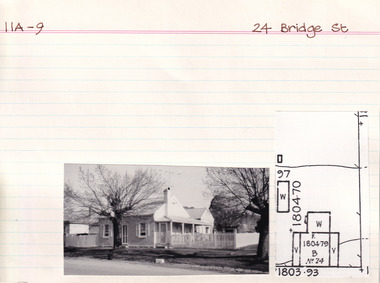 The Beechworth Burke Museum Research Collection
Card (Series) - Index Card, George Tibbits, 24 Bridge Street, Beechworth, 1976
George Tibbits, University of Melbourne. Faculty of Architecture, Building and Town & Regional PlanningIndex system that support the research for Beechworth : historical reconstruction / [by] George Tibbits ... [et al]Arranged by street names of BeechworthEach index card includes: street name and number of property, image of property, allotment and section number, property owners and dates of ownership, description of the property according to rate records, property floor plan with dimensions.beechworth, george tibbitsbeechworth, george tibbits -
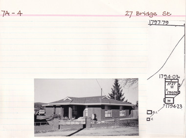 The Beechworth Burke Museum Research Collection
Card (Series) - Index Card, George Tibbits, 27 Bridge Street, Beechworth, 1976
George Tibbits, University of Melbourne. Faculty of Architecture, Building and Town & Regional PlanningIndex system that support the research for Beechworth : historical reconstruction / [by] George Tibbits ... [et al]Arranged by street names of BeechworthEach index card includes: street name and number of property, image of property, allotment and section number, property owners and dates of ownership, description of the property according to rate records, property floor plan with dimensions.beechworth, george tibbitsbeechworth, george tibbits -
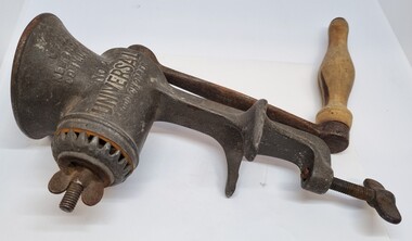 Wodonga & District Historical Society Inc
Domestic object - Meat mincer / Food chopper
The Universal Food Chopper was a common domestic item internationally and throughout Australia. It was manufactured by the Landers, Frary & Clark company ( L.F. &C.). It was first sold in 1897, and proved to be so popular that the company still featured it in their catalogue sixty years later. It was marketed as a device that not only ground meat, but also processed vegetables. The number 2 on the device referred to the size of the grinder, with the 3 model being the largest for heavy-duty use and the 00 model the smallest. This appliance was a common domestic item used throughout AustraliaA cast iron and wood domestic appliance. The food chopper has a large screw on the base which allowed it to be anchored to a table or work bench. Food items were placed in the the cavity at the top and the user wound the handle to force the food through the blade. Different attachments allowed adjustments to the size the food was chopped.On Side 1: Pat. Oct.12, 1897/ Apr. 18, 1899/ Re Sept. 5, 1899 On Side 2 : LF & Co. /New Britain / CONN USA / No 2/ UNIVERSAL FOOD CHOPPERfood chopper, kitchen appliances, food preparation -
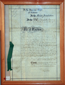 City of Moorabbin Historical Society (Operating the Box Cottage Museum)
Document - Will of Elizabeth Avis-Box 1914, 1914
Elizabeth Avis- Box 1835-1913 was born in Sussex, married William Box in 1854 and arrived in Melbourne in 1855. William’s parents George and Mary Box and his siblings sailed with them. William & Mary at first leased land in the area of the ‘Dendy Special Survey Brighton 1841’ and then purchased the property with the pioneer cottage 1868 & 1869. William & Elizabeth established a market garden and raised 13 children. 1888 they built a larger 2nd house in front of the original cottage. William died in 1902 and Mary sold 9 acres in 1908 to W. .Snowden Anderson – it later became Joyce Park where the reconstructed Box Cottage Museum now stands. After Elizabeth died her daughters Ada and Violet lived on the 1 acre property until 1917 when August Reitman, a potter and monumental mason, leased the house and land. He established his pottery business and purchased the property in 1935. The business moved in 1953 but continued to use the cottage as a workshop/ storeroom until it was sold to Lewis Timber P/L in 1970. Elizabeth & William Box settled in the pioneer Cottage in Jasper Road East Brighton 1868 and established a market garden whilst raising their 13 children. This Cottage was reconstructed in Joyce Park, Ormond 1984 and is the home of City of Moorabbin Historical Society. In 1960 many local residents responded to a call for the donation of historical artefacts and the Box Cottage Museum now preserves this eclectic collection for the community.The original Last Will & Testament of Elizabeth Avis Box September 1914In the Supreme Court / of Victoria / In the Probate Jurisdiction / In the Will of Elizabeth Box late of / Jasper Road Bentleigh in the State of / Victoria Widow deceased. Be it known ............. Given at Melbourne this ( 21st September 1914) Signed A Carter / Registrar top left corner 79637 / Snowball ( X232) Bottom left corner 10/9/...box elizabeth, box william, moorabbin, bentleigh, brighton, ormond, pioneers, market gardeners, box george, box mary cripps, reitman august, anderson w. snowden, joyce park ormond, box cottage museum dendy’s special survey brighton 1841,