Showing 13844 items matching "tasmanian-built"
-
 Ballarat Tramway Museum
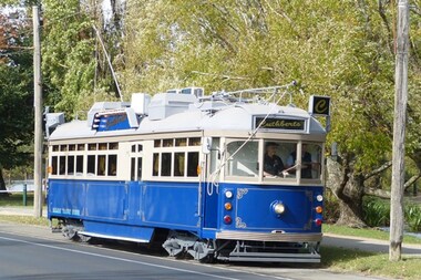
Functional Object - Tramcar, Melbourne and Metropolitan Tramways Board (MMTB), Restaurant Tram Cuthberts 939, 1948
On of a class of 120 trams built at Preston Workshops between 1939 and 1951. Third tram to be converted to a Colonial Tramcar Restaurant Tram. Of the six trams converted, the only former Melbourne Restaurant tram in use currently (March 2019), trams 4, 5, and 6 having been withdrawn during October 2018.Four motor bogie tram - ex Melbourne - tram No. 939 - One of a class of 120 trams built at Preston Workshops between 1939 and 1951. Third tram to be converted to a Colonial Tramcar Restaurant Tram. Of the six trams converted, the only former Melbourne Restaurant tram in use currently (March 2019), trams 4, 5, and 6 having been withdrawn during October 2018. The tram was built by the MMTB as No. 939 in 1948 at Preston Workshops as a standard SW6 tramcar. It was resident for most of its life at Camberwell, Kew and South Melbourne depots and finally Southbank depot. Heavily rebuilt internally to give a flat floor, air-conditioned, 240V and 24V systems fitted along with changes to bulkheads and position of the passenger door and a goods door in 1994. The tram was converted into Melbourne Restaurant tram No. 3 in 1994/95, being launched on 8-2-1995. While in the later part of its use by the Colonial Tramcar Restaurant Co, it was named “Valentine” during July 2008. It was withdrawn from service in May 2012, when it was replaced by No. 935 (Restaurant No. 6). In August 2014, the Museum received a grant from the Victorian Government of $40,000 to refurbish tram – part of the Transport Investing in Regions Program. The tram was relocated to the Ballarat depot on 29/10/2014. Refurbishment work was completed during March 2016 and the tram was formally launched on 5/4/2016.. The tram is named after Sir Henry Cuthberts (1829 - 1907), the first Chairman of the Ballaarat Tramway Co (the horse tram operator). Sir Henry was a Ballarat based solicitor, member of the Legislative Council, Knighted in 1897 and strong supporter of many Ballarat institutions. Photo Warren Doubleday 5-4-2016.trams, cuthberts 939, restaurant tram, sw6 class, tram 939 -
 Bendigo Historical Society Inc.
Newspaper - NEWSPAPER COLLECTION: BENDIGO ADVERTISER VARIOUS ARTICLES
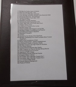
1) Bendigo the Golden Heart of Victoria 2) News from Bendigo May, 1973 3) Some Scenes of Bendigo Yesteryear 4) Cover Bendigo Advertiser Souvenir of the Shamrock Hotel 5) Saving the Shamrock - Doug McClure 6) Farewell Bendigo's Trams April, 1972 7) 100 Years of Trams 8) Gold Mine a Popular Attraction 9) Tomorrow the end (Trams) April 1972 10) Trams 1890-1903-1972/ Photo New Chum 11) Vintage Talking Trams 12) In Search of a Home for Sun Loong 13) Bendigo Dragon City 14) History Indicates that Dragons is not as Silly 15) Bendigo's Dragon is Something to be Proud of 16) Unravelling the Dragon's Mysteries 17) Reputation Precede it 18) Tourism 19) Haunted by the Ghosts of the Gold Rush 20) Bendigo Undertaking Firm Installs Complete Motor Funeral Equipment 21) Built on the Foundations of Gold 22) Photos: Bridge Street - Oakley's Establishment 23) A City Built on reefs of Fabulous Wealth 24) Bendigo Company Has High Hopes for Old Mine 25) The Central Deborah 26) Central Deborah Reaches New Depths 27) WMC Prepares the Way for Bendigo Mining Revival 28) Historical Background of Fortuna 29) Opening of TAFE College 30) 60 Protesting Nurses Greet the Premier 31) A History Written in Bricks 32) The Golden Age of Bendigo Theatre Part 1 33) The Golden Age of Bendigo Theatre Part 2 34) J.H. Curnow is Back Home 35) Fortuna Historical Background 36) Photos of Fortuna. Folder 110 now in Box 417. AV 03/11/2022bendigo, goldfields, tourism, history -
 Bendigo Historical Society Inc.
Document - Black and white laminated photo of flow of water from Lake Eppalock. 1964
John Perry Collection. Laminated copy of photo of crowd watching flow of water from the opened valve at the wall of Lake Eppalock during its commissioning. March, 1964. Lake Eppalock was created by flooding to town of Wild Duck. The dam was built by the State Rivers and Water Supply Commission of Victoria. The dam wall height is 45 metres (148 ft) and the main embankment is 1,041 metres (3,415 ft) long. At 100% capacity the dam wall was designed to hold back 304,651 megalitres (6.7014×10¹⁰ imp gal; 8.0480×10¹⁰ US gal) of water. The surface area of Lake Eppalock is 3,011 hectares (7,440 acres) and the catchment area is 2,124 square kilometres (820 sq mi). The controlled spillway is capable of discharging 8,040 cubic metres per second (284,000 cu ft/s). Lake Eppalock supplies both stock and domestic water to the Campaspe irrigation district. It also serves as a water supply to Bendigo and Heathcote and, in more recent times, Ballarat. The lake is a major attraction for those engaging in watersports, with a number of tourist parks and accommodation facilities available. Permissible activities on the lake include high-speed boating, water skiing, sailing, canoeing, fishing and swimming. The lake's water levels were low for approximately eight years between 2002 and 2010 during a prolonged drought, which restricted the amount of recreational activity until rainfall in the latter half of 2010 returned the lake to 100 percent capacity. Built between 1961 and 1964, Lake Eppalock remains the only water storage on the Campaspe River system.water, dam, reservoir, eppalock, wild duck -
 Bendigo Historical Society Inc.
Map - Map of Lake Eppalock shoreline when empty
John Perry Collection. Laminated copy of map detailing Lake Eppalock shoreline when empty. Circa 1951. Has colored highlighter lines following roads leading to lake shoreline and various inundated old roads and tracks on lakebed. The dam was built by the State Rivers and Water Supply Commission of Victoria. The dam wall height is 45 metres (148 ft) and the main embankment is 1,041 metres (3,415 ft) long. At 100% capacity the dam wall was designed to hold back 304,651 megalitres (6.7014×10¹⁰ imp gal; 8.0480×10¹⁰ US gal) of water. The surface area of Lake Eppalock is 3,011 hectares (7,440 acres) and the catchment area is 2,124 square kilometres (820 sq mi). The controlled spillway is capable of discharging 8,040 cubic metres per second (284,000 cu ft/s). Lake Eppalock supplies both stock and domestic water to the Campaspe irrigation district. It also serves as a water supply to Bendigo and Heathcote and, in more recent times, Ballarat. The lake is a major attraction for those engaging in watersports, with a number of tourist parks and accommodation facilities available. Permissible activities on the lake include high-speed boating, water skiing, sailing, canoeing, fishing and swimming. The lake's water levels were low for approximately eight years between 2002 and 2010 during a prolonged drought, which restricted the amount of recreational activity until rainfall in the latter half of 2010 returned the lake to 100 percent capacity. Built between 1961 and 1964, Lake Eppalock remains the only water storage on the Campaspe River system.map, eppalock, reservoir, lake, water -
 Bendigo Historical Society Inc.
Document - Directions to Lake Eppalock with road descriptions and map
John Perry Collection. Laminated copy of 'Directions to Lake Eppalock'. Gives directions in relationship of Lake Eppalock to Bendigo, Kyneton and Heathcote. Undated. Gives basic descriptions of bridges on lakebed, ford crossings on lakebed and inundated dwellings on lakebed. The dam was built by the State Rivers and Water Supply Commission of Victoria. The dam wall height is 45 metres (148 ft) and the main embankment is 1,041 metres (3,415 ft) long. At 100% capacity the dam wall was designed to hold back 304,651 megalitres (6.7014×10¹⁰ imp gal; 8.0480×10¹⁰ US gal) of water. The surface area of Lake Eppalock is 3,011 hectares (7,440 acres) and the catchment area is 2,124 square kilometres (820 sq mi). The controlled spillway is capable of discharging 8,040 cubic metres per second (284,000 cu ft/s). Lake Eppalock supplies both stock and domestic water to the Campaspe irrigation district. It also serves as a water supply to Bendigo and Heathcote and, in more recent times, Ballarat. The lake is a major attraction for those engaging in watersports, with a number of tourist parks and accommodation facilities available. Permissible activities on the lake include high-speed boating, water skiing, sailing, canoeing, fishing and swimming. The lake's water levels were low for approximately eight years between 2002 and 2010 during a prolonged drought, which restricted the amount of recreational activity until rainfall in the latter half of 2010 returned the lake to 100 percent capacity. Built between 1961 and 1964, Lake Eppalock remains the only water storage on the Campaspe River system.water, dam, directions, eppalock -
 The Beechworth Burke Museum
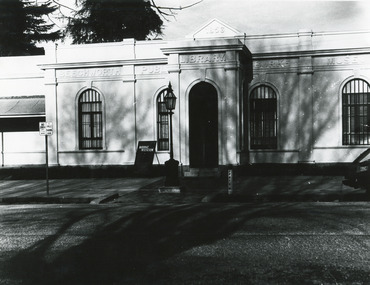
Photograph, c1970
Historical photograph taken of the frontage of the Burke Museum in Beechworth. As Australia’s oldest regional museum, the building used for the Burke Museum was originally built as the Beechworth Athenaeum, and was later dedicated as a museum in memorial to the explorer Robert O’Hara Burke, who died on the Burke and Wills expeditions in 1861. The Burke and Wills exhibitions were a significant colonial event that was memorialised in paintings, buildings, monuments, and statues. The photograph has historical significance, connecting with various themes such as exploring, establishing pathways, and significant colonial events or persons. The photograph depicts the frontage of the Burke Museum, which was dedicated as a memorial to the explorer Robert O’Hara Burke, who died on the Burke and Wills expeditions in 1861. Robert O’Hara Burke was a significant person who was connected to both Beechworth and to an important colonial event, the Burke and Wills expeditions. Born in Ireland, Burke migrated to Australia in 1853 and nearly a year later, was appointed to senior inspector at Beechworth. Described as quick-tempered yet generous, Burke later joined an expedition to explore the interior of the Victorian colony, which was later termed the Burke and Wills expeditions. While the expeditions generated a significant amount of interest, the objectives of the Burke and Wills expeditions were hazy, as was its planned route, leading to disaster on the trip as group infighting, poor provisions, and a lack of clear instructions ultimately resulted in Burke’s death. Regardless, the Burke and Wills expeditions promoted discovery and endures today in popular memory.Black and white rectangular photograph printed on paper.Obverse: 1856/ BEECHWORTH/ PUBLIC/ LIBRARY/ BURKE/ MUSEUM/ BURK MUSEUM/ (parking signs illegible) Reverse: BMM 84-2-1/ A02989 1997 2696/ BMM 84-2-3burke museum, beechworth, beechworth athenaeum, athenaeum, memorial, robert o'hara burke, robert burke, burke and wills exhibitions -
 Orbost & District Historical Society
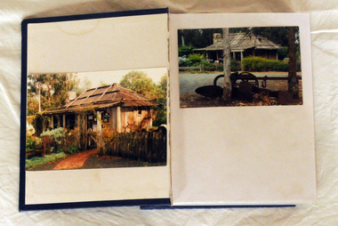
album, Orbost Visitor Information Centre, 1997
The original slab hut was built in 1872 as a family dwelling on a site about 3 km upstream from the junction of the Buchan and Snowy Rivers about 40 kms from Orbost on the Yalmy Rd. No nails were used in the construction; it was all wired together. After a period in storage the Slab Ht was opened in its present location in Orbost as the Information Centre in 1987. This album documents an important event in Orbost.A photo album with a navy blue cardboard cover with gold embossing on the front and spine. It contains 32 photos of the 1997 10 year anniversary celebration of the establishment of the Slab Hut - the Orbost Visitor Information Centre. It also contains 3 postcards and 2 fridge magnets.slab-hut album orbost -
 Orbost & District Historical Society
black and white photograph, 1916
About 1912 work began at Newmerella on clearing the track for the railway line from Bairnsdale to Orbost. A canvas town sprang up on the higher land adjacent to the river flats. Local farmers supplied meat, milk and fresh produce to the camp, as well as gaining employment carting and labouring. The line opened in 1916, the Orbost railway station being built on the Newmerella side of the river. This item is associated with the history of the Orbost-Bairnsdale railway line and therefore reflects the role that the rail line played in the social and economic history of Orbost. On April 10 1916, the first scheduled train service left Orbost for Bairnsdale. The Bairnsdale-Orbost railway was opened to serve the agricultural and timber industry. Because of the decline in traffic and heavy operating costs, the line was finally closed in August, 1987.A black / white photograph of a group of people standing next to a train carriage.orbost-railway east-gippsland-railway celebration-opening-of railway -
 Ringwood and District Historical Society
Piece of concrete, City of Ringwood, Concrete from the facade of the old Ringwood Town Hall demolished in 1971, 1927
The two storey facade of the Ringwood Town Hall was built in 1927 at a cost of 6,000 pounds. Behind it the council worked out of the old mechanics institute. As the need for space grew, the first Ringwood fire station, the baby health centre and council's health department squeezed onto the site. A free library and cinema also operated from the town hall for many years.Two lumps of concrete from the facade of the old Ringwood Town Hall. Red at the centre, soot and dirt marked on the outside.; This was the first debris from the demolition of the old Ringwood Town Hall, knocked off the front western pillar by the mayor Cr Jack McRae at the invitation of the purchaser Hanover Holdings Ltd, on Thursday 22-Apr-1971. +Additional Keywords: McRae, Cr J.M. / Carter, RichardFirst debris from the demolition of the old Ringwood Town Hall, knocked off the front western pillar by the mayor Cr Jack McRae at the invitation of the purchaser Hanover Holdings Ltd, on Thursday 22-Apr-1971. -
 Warrnambool and District Historical Society Inc.
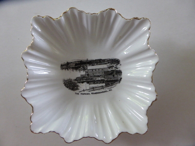
Plate, The Hopkins Warrnambool
This is a dish sold to tourists visiting Warrnambool in the 1920s as a souvenir of Warrnambool and the Hopkins River. It was made by the Royal Stafford Bone China Company which was founded in the mid 1800s and based in Stoke-on-Trent in Staffordshire, England. The scene depicting the Hopkins River mouth shows the Lyndoch windmill, the Lyndoch bungalow built in the early 1920s by Florence Lake, Proudfoots Boathouse and the Rowing Club building. This dish is an interesting example of the high-quality souvenirs sold to tourists in the mid 1920s. Local Warrnambool residents may also have purchased an item such as this. Souvenir items depicting local scenes are still sold today in most places in Australia.This is a square-shaped white china dish with a fluted edge and gold colouring on the edge of the fluting. In the centre of the dish is a black and white image of the mouth of the Hopkins River near its mouth. On the base is a blue stamp of the maker of the dish. ‘The Hopkins, Warrnambool, Vic.’ ‘Guaranteed Royal Stafford English Bone China, Made in England’ hopkins river, warrnambool, lyndoch, warrnambool, history of warrnambool -
 Kiewa Valley Historical Society
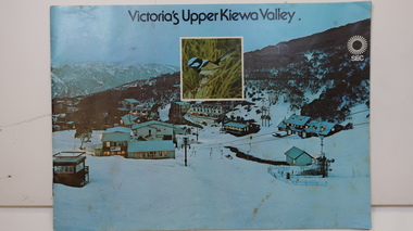
Booklet - SEC x2, 1. Victoria's Kiewa Valley 2. Victoria's Upper Kiewa Valley, No. 2 is dated October 1978
The State Electricity Commission of Victoria built the Kiewa Hydro Electric Scheme and was keen to promote tourism in the area. The booklet includes Facilities, Falls Creek Ski Resort, the Kiewa Works Area, the Three Floras of Bogong, the Geology of the Kiewa area, the Bird and Animal life of Bogong and the Kiewa Hydro Electric Scheme. The colored photos and the map on the back appeal to the reader/tourist.The SECV promoted tourism in the Kiewa Valley especially the area of the Kiewa Hydro Electric Scheme. This booklet is attractive and informative with a lot of detail. This proved to be the early stages of tourism in the area in what is now a very popular tourist destination and the main industry for the Upper Kiewa Valley.Blue cover with photo of Falls Creek at night. Title in black print at the centre top under which is an insert photo of a blue wren and SEC logo in white towards the top far right. Back cover is light green with a tourist map of the area. The text is complimented with brightly colored photos throughout.state electricity commission of victoria; kiewa hydro electric scheme; tourism; bogong; flora; fauna; geology; -
 Warrnambool and District Historical Society Inc.
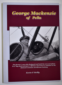
Book - Biography of George Mackenzie, Kevin O'Reilly, George Mackenzie of Pella, 2019
Biographical details of George Mackenzie, a pioneer aviator in VictoriaThis is a book of 68 pages with a white cover with two black and white photographs set in a red background. The printing on the cover is yellow and white. The pages contain black and white photographs and printed text.non-fictionBiographical details of George Mackenzie, a pioneer aviator in Victoriageorge mackenzie pioneer aviator, belmont common aerodrome geelong, pratt aviation company geelong -
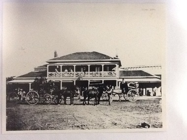 Port of Echuca
Photograph, Approx. 1970's
The Bridge Hotel was built by Henry Hopwood to house visitors to the town crossing the Murray River on his punt , which was situated just below the Bridge Hotel on the Murray River. The accommodation was spacious and grand! In the right back corner of the photograph, the 'lantern' roof of the St George's Hall can be seen. The street is level with the front entrance to the Hotel, which is very different to what it is today.The photograph shows hotel activities and accommodation in the late 19th Century. The Bridge Hotel was a very busy place as can be seen with women on the balcony, a stage coach full of people, laden carts and buggies.The Bridge Hotel Echuca - photo taken looking south towards front of building. Four people can be seen on the balcony and several gathered under the verandah. In the foreground are several horse-drawn carriages. The road in front of the hotel is unmade and very wide, with the roof of St.George's Hall seen over the right (western) wing of the hotel. Verso: Bridge Hotel, 1860s? St. George's Hall in background.bridge hotel, henry hopwood, lantern roof, st.george's hall, 1870s -
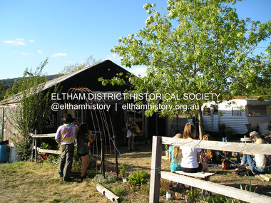 Eltham District Historical Society Inc
Photograph, Fay Bridge, Bobby Bununngurr appearing at the Black Barn Gallery, Christmas Hills, January 2016
The Black Barn gallery at Christmas Hills was designed and built by Justus Jorgensen, founder of Montsalvat. The space has been a part of community and the arts for three generations. Bobby Bununngurr is a songman and multi art form creative from Ramingining (his outstation is Ngalayindi) in Central Arnhem Land. Fund raising event at Christmas Hills for the Black Barn gallery - being filmed for a video fay bridge collection, 2016-01, black barn gallery, bobby bununngurr, christmas hills, maurice hurry, rhiannon jorgensen, sebastian jorgensen -
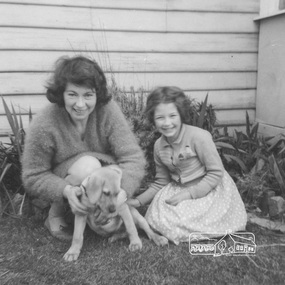 Eltham District Historical Society Inc
Work on paper (item) - Photograph, Ada and Susan Zull with a puppy, October 18, 1961
Ada Zull and her daughter Susan photographed with a puppy in front of a weatherbaord house, possibly their home in Burnswick. Early 1960s. Florence Ada Zull, known as Ada was an illustrator for the 'New Idea for Women" magazine. In 1961 she lived in Brunswick. From 1963 she and her husband Robert built a Alistair Knox designed house at Lot 8. Metery Road, Eltham ada zull, susan zull, susan bennett, puppy, pet -
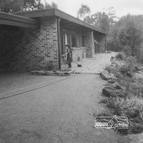 Eltham District Historical Society Inc
Work on paper (item) - Photograph, 2 Metery Road, Eltham South
Robert and Ada Zull built an Alistair Knox designed house at 2 (lot 8) Metery Road, Eltham, a one acre property for their family of five in the mid 1960s. Susan Bennett, nee Zull's reminiscences are published in EDHS Newsletter, February and April 2020. "..My father bought second hand bricks and began to pave them over the quagmire outside..."This series of photographs together with the account of personal remiscences provide a unique document of the construction of an Alistair Knox designed home. Knox was a pioneer in the use of mudbricks and recycled materials and is significant to his contribution of this style of architecture in Eltham and the wider Shire of Nillumbik.zull family, eltham south, 2 metery road, alistair knox, bush block, construction, vw beetle -
 Federation University Historical Collection
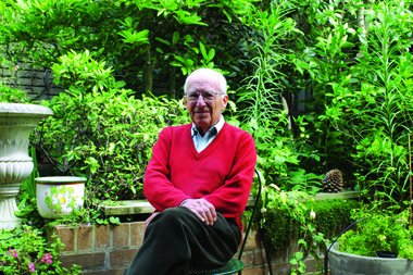
Photograph, David Caro
Born in 1922 David Caro was educated at the Universities of Melbourne and Birmingham. Caro and John Rouse built the world’s first high speed, variable energy nuclear accelerator or Cyclotron. He was appointed as Vice-Chancellor at the University of Melbourne, and he later became Vice-Chancellor at the Northern Territory University and Chancellor at the University of Ballarat (later Federation University. He was awarded an AO in 1986. Photograph of David Caro, Chancellor of the University of Ballarat. david caro, chancellor, university of ballarat -
 Marysville & District Historical Society
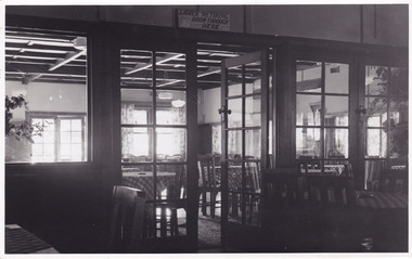
Photograph (Item), Roy Liebig, Unknown
A black and white photograph of the view looking from the supper room into the dance room at the Crossways Cabaret in Marysville. The Crossways was built in the early 1920s and is the oldest building in Marysville. The Crossways historic inn survived the 2009 Black Saturday bushfires thanks to the efforts of its c-owner Greg Cherry and, in the days after the fires, provided a much-needed refuge to the Marysville community and firefighters. A black and white photograph of the view looking from the supper room into the dance room at the Crossways Cabaret in Marysville.Looking from the supper room/ into the dance room at the/ Crossways Cabaret./ Marysville Visit.marysville, victoria, australia, photograph, the crossways cabaret, the crossways, crossways, crossways country inn, crossways historic inn, 2009 black saturday bushfires, accommodation, roy liebig -
 Mission to Seafarers Victoria
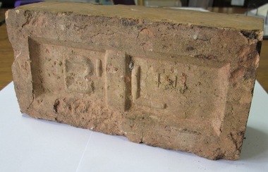
Ceramic - Brick, 1936-1937
This brick was salvaged by the donors, members of PMHPS and former residents of Port Melbourne from the ruins of the Art Deco Mission to Seamen also known as King George V memorial building, built in 1937 by Harry Norris and demolished in 1995. Used in their former courtyard the donors, who recently moved to Docklands offered the brick to MTSV when they sold their Port Melbourne house in 2017.One of the few remaining tangible materials from the architecturally significant Mission to Seamen, the George V Memorial building dedicated in 1937 and demolished in the 1990s. The Brick adds to the MTSV collection of Port Melbourne material from the 1930s. See also Research and clippings folder and records such as 0641 and 0233. The brick was donated to the Mission by the Port Melbourne Historical and Preservation Society (PMPHS) who had two bricks in their collection.A terra cotte standard construction Brick Two embossed letters on face of the brick "B" and "L"port melbourne, king george v, mission to seamen building, brickwork, art deco, harry a. norris, alfred m. nicholas, beach street, 1937 -
 Mission to Seafarers Victoria
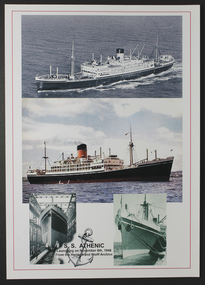
Flyer - Souvenir, late 20th Century
The SS Athenic was one of 2 vessels of the Shaw Savill Line. One became a whale factory ship and the second a passenger ship built and launched by Harland and Wolff in1944 and had maiden voyage 1947 between London and New Zealand. Donor of this document Mr GW Duncan sailed on the maiden voyage and has also gifted sample menus from that trip.Mariner Duncan had a particular regard for the Mission to Seafarers. A plate for display on a commissioned new table at the MTSV acknowledges his bequest and the material donated. Collectively the G W Duncan material includes: photographs, professional data memorabilia and written and commercially printed resources. The memorabilia relates to his career at sea and in particular the role of an engineer, including a handwritten manual of notes and references relating to the mechanical and engineering aspects and areas of responsibility for maintenance. Double sided colour flyer with 'collaged' arrangement of various reproduced photographs of SS AthenicAt lower right edge on one side: " SS Athenic launching on November 6th, 1946 / From the Harland & Wolff Archive"shaw savill line, ss athenic, harland and wolff, george winfield duncan (1922-2017), ship engineer, 1946 -
 Lorne Historical Society
Functional object - Thunderbox, Circa 1930’s
The Great Ocean Road was built by World War 1 returned servicemen. Tolls were collected as sections of the road were completed. The first toll house was at Grassy Creek. It operated from 1922 to 1932 when it was moved to The Springs at Cathedral Rock about 5 km east of Lorne. The thunderbox is believed to have been used here at sometime between 1932 and 1936This is a rare archeological find. Items n this location are often damaged by the action of the sea and salt air. It is intimately associated with the early years of the development of the Great Ocean Road and the daily life of the workers. It is a typical example of the type of toilet used at the time. This reclaimed timber thunder box is enclosed on three sides. There is a circular hole on the top with a wooden handled lid attached by a chain. Inside is a steel can.great ocean road construction, returned sevicemen world war 1, great ocean road toll houses, toilet -
![Photograph - Digital Image, Ray White Greensborough, 3 St Helena Road Greensborough [veranda and views], 2017_](/media/collectors/4f729f5697f83e03086015b8/items/5d3c002521ea6715d01d7aa7/item-media/5d3c004b21ea6715d01da9f2/item-fit-380x285.jpg) Greensborough Historical Society
Greensborough Historical SocietyPhotograph - Digital Image, Ray White Greensborough, 3 St Helena Road Greensborough [veranda and views], 2017_
Exterior photographs of the house at 3 St Helena Road Greensborough (corner Diamond Creek Road), showing the veranda and views over Greensborough. The house was built in 1920. These photographs are from the Ray White sales brochure 2017. The 4 bedroom property sold in December 2017 for $900,000; previous sales: April 2009, $600,000; June 1981, $36,500; June 1976, $32,500. Digital copy of 4 colour photographs.st helena road greensborough, diamond creek road greensborough -
![Photograph - Digital Image, Ray White Greensborough, 3 St Helena Road Greensborough [interiors], 2017_](/media/collectors/4f729f5697f83e03086015b8/items/5d3c01c421ea6715d01f3f5c/item-media/5d3c01ea21ea6715d01f7078/item-fit-380x285.jpg) Greensborough Historical Society
Greensborough Historical SocietyPhotograph - Digital Image, Ray White Greensborough, 3 St Helena Road Greensborough [interiors], 2017_
Interior photographs of the house at 3 St Helena Road Greensborough (corner Diamond Creek Road), showing lounge, dining, kitchen and hallway. The house was built in 1920. These photographs are from the Ray White sales brochure 2017. The 4 bedroom property sold in December 2017 for $900,000; previous sales: April 2009, $600,000; June 1981, $36,500; June 1976, $32,500. Digital copy of 8 colour photographs.st helena road greensborough, diamond creek road greensborough -
 Greensborough Historical Society
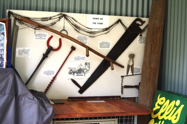
Photograph - Digital image, Marilyn Smith, Ellis Cottage, May 2016: Farm Implement Display, 27/05/2016
In May 2016, the Nillumbik Historical Society invited Greensborough Historical Society to visit its historical centre at Ellis Cottage in Diamond Creek. Ellis Cottage was built in 1865 and is made of local uncut stone. The cottage is a typical farmers residence of this period. The stone construction is unique in this district as most construction is weatherboard. This photo shows a farm implement display in the Historical Centre.Digital colour photographellis cottage, nillumbik historical society inc. -
 Greensborough Historical Society
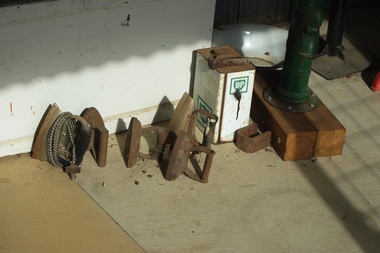
Photograph - Digital image, Marilyn Smith, Ellis Cottage, May 2016: Collection of Irons, 27/05/2016
In May 2016; the Nillumbik Historical Society invited Greensborough Historical Society to visit its historical centre at Ellis Cottage in Diamond Creek. Ellis Cottage was built in 1865 and is made of local uncut stone. The cottage is a typical farmers residence of this period. The stone construction is unique in this district as most construction is weatherboard. This photo shows a collection of irons on display in the Historical Centre.Digital colour photographellis cottage, nillumbik historical society inc. -
 Greensborough Historical Society
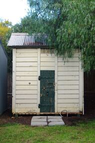
Photograph - Digital image, Marilyn Smith, Ellis Cottage, May 2016: Outside building, 27/05/2016
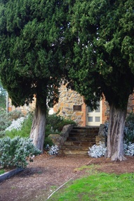
In May 2016, the Nillumbik Historical Society invited Greensborough Historical Society to visit its historical centre at Ellis Cottage in Diamond Creek. Ellis Cottage was built in 1865 and is made of local uncut stone. The cottage is a typical farmers residence of this period. The stone construction is unique in this district as most construction is weatherboard. This photo shows a small outside building in the grounds of the Historical Centre.Digital colour photographellis cottage, nillumbik historical society inc. -
 Greensborough Historical Society
Photograph - Digital image, Marilyn Smith, Ellis Cottage, May 2016: Steps to front, 27/05/2016
In May 2016, the Nillumbik Historical Society invited Greensborough Historical Society to visit its historical centre at Ellis Cottage in Diamond Creek. Ellis Cottage was built in 1865 and is made of local uncut stone. The cottage is a typical farmers residence of this period. The stone construction is unique in this district as most construction is weatherboard. This photo shows steps to front door of Ellis Cottage.Digital colour photographellis cottage, nillumbik historical society inc. -
 Greensborough Historical Society
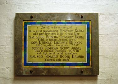
Photograph - Digital image, Marilyn Smith, St Katherine's Church St Helena: Beale family plaque, World War 1, 29/05/2015
St Katherine's Church St Helena dates from 1858. The Church was built by Major Anthony Beale in memory of his wife Katherine Rose Beale. This photograph shows a plaque that commemorates the death of three grandsons of Anthony Beale who were killed in World War I: Robert Beale, Harold Wilcox and Robert James, and his great grandson Robert Brown.Digital copy of colour photographst katherines church st helena, anthony beale, beale family -
 Greensborough Historical Society
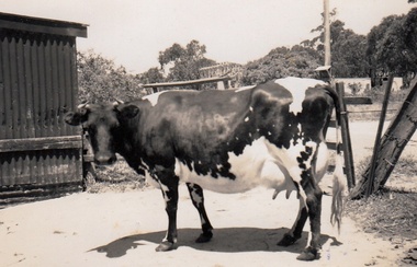
Photograph - Digital Image, Cherel Sartori, Cows at Kell's Cottage 1956, 01/01/1956
Photograph of a cow at Kell's Cottage in the 1940s. The house was built 1917, at 112 Henry Street Greensborough by William Mitchell on the 60 acre dairy farm owned by Ethel and Walter Kell. This collection of photographs was copied by Cherel Sartori (who owned the house from 1990-2000), following a visit by Claude Amiet who lived in the house as a child in the early 20th century.An indication of the rural aspect of this area in the mid-20th century.Digital copy of black and white photographkell's cottage, claude amiet, cherel sartori -
 Greensborough Historical Society
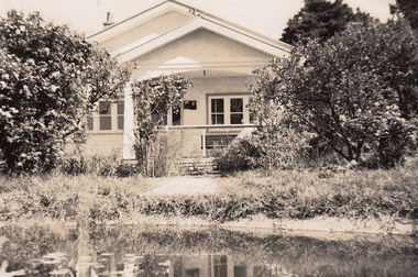
Photograph - Digital Image, Cherel Sartori, Electricity connected in Henry Street, 1950s, 1956c
Kell's Cottage with electricity connected 1950s. The house was built 1917, at 112 Henry Street Greensborough by William Mitchell on the 60 acre dairy farm owned by Ethel and Walter Kell. This collection of photographs was copied by Cherel Sartori (who owned the house from 1990-2000), following a visit by Claude Amiet who lived in the house as a child in the early 20th century.An indication of the rural aspect of this area in the mid-20th century.Digital copy of black and white photographkell's cottage, claude amiet, cherel sartori