Showing 542 items matching " canal"
-
 St Kilda Historical Society
Photograph - Photo map, 17/01/1951
One of a series of photo-maps produced for the Department of Crown Lands and Survey (1857-1983). For correlation with a current map, and access to other historical photo maps of Victoria, see the Historic Photo-Maps Index published by the Department of Environment, Land, Water and Planning at https://services.land.vic.gov.au/DELWPmaps/historical-photomaps/Black and white aerial photograph1414-21 538 Run 19 Lens 12" Melbourne Metropolitan 12150 17.1.51 M586st kilda, st kilda botanical gardens, peanut farm, elwood, 1951, point ormond, elwood canal, st kilda beach -
 St Kilda Historical Society
Photograph - Photo map, 30/01/1960
One of a series of photo-maps produced for the Department of Crown Lands and Survey (1857-1983). For correlation with a current map, and access to other historical photo maps of Victoria, see the Historic Photo-Maps Index published by the Department of Environment, Land, Water and Planning at https://services.land.vic.gov.au/DELWPmaps/historical-photomaps/Black and white aerial photographVic 1091-112 Melbourne & Metropolitan Project Run 23East 30.1.1960 Lens 10" 8.200elwood, point ormond, elwood park, elwood canal, 1960 -
 St Kilda Historical Society
Photograph - Photo map, 14/12/1963
One of a series of photo-maps produced for the Department of Crown Lands and Survey (1857-1983). For correlation with a current map, and access to other historical photo maps of Victoria, see the Historic Photo-Maps Index published by the Department of Environment, Land, Water and Planning at https://services.land.vic.gov.au/DELWPmaps/historical-photomaps/Black and white aerial photographVic 1806 Melbourne 1964 Project Run 18 14.12.63 Lens 205 152.70 M/M 5.150 161elsternwick, elsternwick park, elwood, elwood canal, elwood beach, elwood park, 1963 -
 St Kilda Historical Society
Photograph - Photo map, 08/02/1966
One of a series of photo-maps produced for the Department of Crown Lands and Survey (1857-1983). For correlation with a current map, and access to other historical photo maps of Victoria, see the Historic Photo-Maps Index published by the Department of Environment, Land, Water and Planning at https://services.land.vic.gov.au/DELWPmaps/historical-photomaps/Black and white aerial photographVic 1916 Melbourne 1966 Project Run 13 E 8.2.66 Lens 122 151.75MM 9.800 111st kilda, balaclava, caulfield, caulfield north, st kilda east, elsternwick, elsterwick park, elwood park, elwood canal, elwood beach, ripponlea, 1966 -
 St Kilda Historical Society
Photograph - Photo map, 11/01/1968
One of a series of photo-maps produced for the Department of Crown Lands and Survey (1857-1983). For correlation with a current map, and access to other historical photo maps of Victoria, see the Historic Photo-Maps Index published by the Department of Environment, Land, Water and Planning at https://services.land.vic.gov.au/DELWPmaps/historical-photomaps/Black and white aerial photographVic 2132 State Aerial Survey Melbourne 1968 Proj. Run 29E 11.1.68 5100 ASL 194elwood, elwood beach, elwood park, elsternwick park, ripponlea, elwood canal, balaclava, st kilda, 1968 -
 St Kilda Historical Society
Photograph - Photo map, 11/01/1968
One of a series of photo-maps produced for the Department of Crown Lands and Survey (1857-1983). For correlation with a current map, and access to other historical photo maps of Victoria, see the Historic Photo-Maps Index published by the Department of Environment, Land, Water and Planning at https://services.land.vic.gov.au/DELWPmaps/historical-photomaps/Black and white aerial photographVic 2132 State Aerial Survey Melbourne 1968 Proj. Run 29E 11.1.68 5100 ASL 196elwood, elwood park, elwood canal, elwood beach, st kilda marina, mc moran reserve, point ormond, 1968 -
 St Kilda Historical Society
Photograph - Photo map, 14/12/1963
One of a series of photo-maps produced for the Department of Crown Lands and Survey (1857-1983). For correlation with a current map, and access to other historical photo maps of Victoria, see the Historic Photo-Maps Index published by the Department of Environment, Land, Water and Planning at https://services.land.vic.gov.au/DELWPmaps/historical-photomaps/Black and white aerial photographVic 1807 Melbourne 1963 Project Run 17 14.12.63 Lens 205 152.70 M/M 5.150 36st kilda, st kilda botanical gardens, balaclava, st kilda east, elwood canal, ripponlea, caulfield north, elwood, caulfield, 1963 -
 St Kilda Historical Society
Photograph - Photo map, Department of Crown Lands and Survey (1857-1983), 22/01/1970
One of a series of photo-maps produced for the Department of Crown Lands and Survey (1857-1983). For correlation with a current map, and access to other historical photo maps of Victoria, see the Historic Photo-Maps Index published by the Department of Environment, Land, Water and Planning at https://services.land.vic.gov.au/DELWPmaps/historical-photomaps/Black and white aerial photographVic 2358 Department of Crown Lands and Survey Victoria,.© Melbourne 1970 Project Run 42E 22.1.70 5,100 ASL 77st kilda, st kilda east, st kilda marina, elwood, elwood canal, elsternwick park, point ormond, balaclava, mc moran reserve, ripponlea, st kilda botanical gardens, peanut farm, 1970 -
 St Kilda Historical Society
Photograph - Photo map, Department of Crown Lands and Survey, 22/01/1970
One of a series of photo-maps produced for the Department of Crown Lands and Survey (1857-1983). For correlation with a current map, and access to other historical photo maps of Victoria, see the Historic Photo-Maps Index published by the Department of Environment, Land, Water and Planning at https://services.land.vic.gov.au/DELWPmaps/historical-photomaps/Black and white aerial photographVic 2358 Department of Crown Lands and Survey Victoria,.© Melbourne 1970 Project Run 43E 22.1.70 5,100 ASL 208elwood, elwood beach, point ormond, elwood park, elwood canal, mc moran reserve, 1970 -
 Whitehorse Historical Society Inc.
Decorative object - Ornament
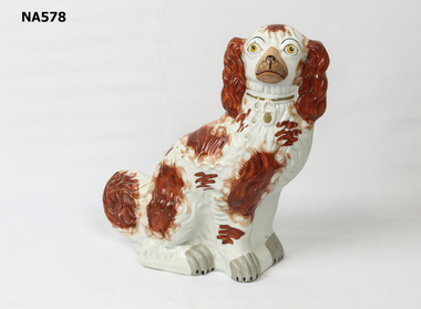
6th May 2009 A large earthenware figure of a spaniel made in the 19th century in Staffordshire and used as a fireside ornament. Also referred to as Staffordshire dogs. They were purchased by errant husbands to comfort irate wives.|Stoke, Burslem, Hanley, Longton and Tunstall were known as the “Five Towns” of the Staffordshire potteries. In the 19th century there were more than 1000 firms working at various times, amongst them Wedgwood, Spode and Ridgway. Largely because of Josiah Wedgwood and the canal system, and later the railways English ceramics spread far and wide. A vast export trade to the Americas and India was from the port of Liverpool. Staffordshire became the pottery supplier of the World. Most factories made figures and tea and dinner sets.|The Comforter Dogs were copied and made by more than one pottery.Staffordshire dog - no makers mark. Right foot cracked. Repair on ear. Some cracks on body.ceramics, porcelain, ornaments -
 Bendigo Historical Society Inc.
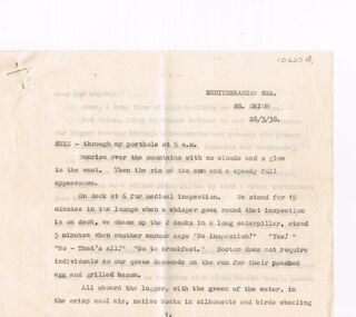
Document - ANONYMOUS DIARY SS. ORION 28/03/1938 PRE WORLD WAR II SUEZ CANAL - EGYPT TOUR, 28/03/1938
Personal Diary Unknown Author located in the Mediterranean Sea aboard the SS. Orion 28/03/1938. Prior to WWII yet not long after the Second Italian-Abyssinian (Ethiopian) War. Tour of Suez, Egypt, Port Said.communication, postal, diary pre wwii tour of egypt, donated in harcourt granite quarries j. blight & co proprietors envelope -
 Queenscliffe Maritime Museum
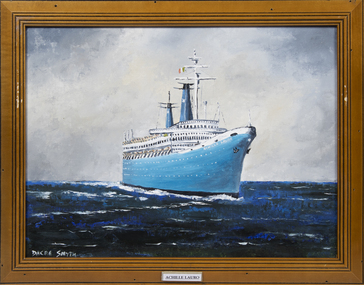
Painting - MV Achille lauro, Dacre Smyth, Achille lauro
MS Achille Lauro was a cruise ship based in Naples, Italy. Built between 1939 and 1947 as MS Willem Ruys, a passenger liner for the Rotterdamsche Lloyd, it was hijacked by members of the Palestine Liberation Front in 1985.Mrs B SmythA framed oil painting of the passenger ship Achille LauroAchille Lauropassenger ship, achille lauro, oil painting, dacre smyth -
 Queenscliffe Maritime Museum
Document - Passenger List, P&O Passenger List RMS Strathaird
RMS Strathaird was the second of a pair to be built and was completed on January 10, 1932. She was preceded by her identical sister the RMS Strathnaver completed on September 2, 1931. They were built by Vickers-Armstrong Ltd, in Barrow-in-Furness, England.RMS Strathaird departed Tilbury on her maiden voyage on February 12 1932, bound for Brisbane Australia sailing via Port Said, Aden, Bombay, Colombo, Fremantle, Adelaide, Melbourne, Sydney and Brisbane, a service she would remain on until the war would put an end to her passenger’s service for six long years! After the Mediterranean had been declared safe in late 1943, the Strathaird was the very first ship to sail through the Suez Canal in 1943. In 1945 she returned to Australia and New Zealand with their troops heading home. The RMS Strathaird was handed back to P&O in December 1947 and after a major refit she departed Tilbury on January 5, 1948. She returned to her regular Australian service but also continued to operate the occasional cruises. Due to demand and the migrant trade, in 1954 the Strathaird was converted to become a one-class liner, accommodating a good 1,252 passengers. Upon completion she departed Tilbury for her first voyage on April 8, 1954. TSS Strathaird departed Tilbury for Australia on March 28, 1961 and she then departed Sydney on May 9. As she sailed from Australia and had passed through the Suez Canal and was now in the Mediterranean she passed P&O’s newest superliner, the 42,570 GRT SS Canberra that had departed the UK on June 2, for Australia and New Zealand.A PDF doc of a Passenger List from the 'RMS Strathaird' passenger list dated September 1952P&O Passenger Listrms strathaird, passenger liners, migrant ships, cruise liners, british travellers -
 Mrs Aeneas Gunn Memorial Library
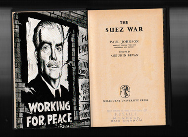
Book, Melbourne University Press, The Suez war, 1957
Why did the Suez War ever come to pass? Why did Eden, against public opinion and without sufficient military capability, decide to invade Egypt? When Gamal Abdel Nasser decided to nationalize the Suez Canal, Britain and France reacted dramatically, beginning a chain of events that ultimately led to war. But why did Nasser nationalize the canal in the first place? And what part did the United States of America play in sparking the conflict that resulted in war? Paul Johnson skillfully and clearly explains the roots of the war, the many different political factors involved, the resultant invasion and its repercussions. First published in 1957, The Suez War walks us through a conflict that many historians feel should never have taken place, and one that Johnson argues has exposed i(t)he real weakness of Britain i never again can we play our unique and honourable role as keeper of the worlds conscience.p.145.non-fictionWhy did the Suez War ever come to pass? Why did Eden, against public opinion and without sufficient military capability, decide to invade Egypt? When Gamal Abdel Nasser decided to nationalize the Suez Canal, Britain and France reacted dramatically, beginning a chain of events that ultimately led to war. But why did Nasser nationalize the canal in the first place? And what part did the United States of America play in sparking the conflict that resulted in war? Paul Johnson skillfully and clearly explains the roots of the war, the many different political factors involved, the resultant invasion and its repercussions. First published in 1957, The Suez War walks us through a conflict that many historians feel should never have taken place, and one that Johnson argues has exposed i(t)he real weakness of Britain i never again can we play our unique and honourable role as keeper of the worlds conscience.suez crisis - 1956, united kingdom - foreign relations - egypt -
Port Melbourne Historical & Preservation Society
Document - Exhibition Catalogue, Joan Winter, Dredging, Draining, Dipping & Shipping: A History of the Foreshore & Low-lying Lands of the City of Port Phillip, Apr 1996
First major exhibition from the Council of Port Phillip was held in 1995. The catalogue material on Port Melbourne was written by PMH&PS members. It toured the city and then a reduced version was sent to sister city, Devonport. Black text and picture of Sandridge from the Esplanade, St Kilda on cover. sandridge lagoon, engineering - canals and drainage, melbourne harbor trust - port of melbourne authority, piers and wharves, piers and wharves - waterside workers, arts and entertainment, transport - shipping, centenary bridge, beacons, fishermans bend, transport - aviation and aerodrome, sport - swimming, flood, local government - city of port phillip, kulin nation, caroline frederica liardet, swallow & ariell ltd, mission to seafarers, emerald hill, st kilda -
Port Melbourne Historical & Preservation Society
Book, Public Works Committee, Borough of Sandridge, Municipal Council of Sandridge - Public Works Committee Minutes, 18560 - 1862
Volume of minutes of Public Works Committee of Sandridge Council dated 20.9.1860Title on labellocal government - borough of sandridge, engineering - roads streets lanes and footpaths, engineering - fences, engineering - canals and drainage, engineering - bridges, fishermans bend, built environment - civic, transport - horse, utilities - gas, sandridge lagoon, mission to seafarers, emerald hill, fire and fire services, william morley, joseph weaver allen, thomas swallow, samuel george isaacs, frederick poolman, robert byrne, john murphy -
Port Melbourne Historical & Preservation Society
Document - Scrapbook relating to Port Melbourne, Newspaper Cuttings, 1900
98 pages of clippings kept by Port Melbourne Town Clerk E.C. CROCKFORD; sequential to item 162. (This also has his bowling scores in back). NB Crockford supposed to have moved to South Melbourne in November, 1909, but this book kept up to 28-07-1910, apparently still in Crockford's handwriting.Notationslocal government - town of port melbourne, engineering - board of works, melbourne harbor trust - port of melbourne authority, sandridge lagoon, livestock, piers and wharves - miscellaneous, amalgamation, royal visits and occasions, law, sport - lawn bowls, transport - tramways, health - general health, business & traders - dairies, flood, transport - horse, transport - railways, environmental issues, fishermans bend, engineering - canals and drainage, built environment - domestic, celebrations fetes and exhibitions, town planning - proposals shelved, natural environment, edward c crockford, town clerks, pumping station, waste disposal, sand carters, business and traders - hotels -
Port Melbourne Historical & Preservation Society
Document - Scrapbook, Newspaper cuttings relating to Port Melbourne, Edward C Crockford, Town Clerk, 1890s
EC CROCKFORD's scrapbook from time he became acting Town Clerk (1892) until he left to serve South Melbourne (1909).Scrapbook kept by Port Melbourne Town Clerk EC CROCKFORD, 1890s: notebook with marbled board covers, 38 ruled pp, some empty. Back of book used upside down. Pasted with clippings related to municipal operation, and ads for contracts (in back). Insert: note on rateslocal government - town of port melbourne, engineering department - town of port melbourne, transport - railways, transport - tramways, engineering - roads streets lanes and footpaths, engineering - canals and drainage, amalgamation, piers and wharves - station pier, business and traders, sport - lawn bowls, health - general health, law, nightsoil, piers and wharves - railway pier, statistics, edward c crockford, town clerks, municipal elections -
Port Melbourne Historical & Preservation Society
Book - Town of Port Melbourne, Arthur Victor Heath, Town Surveyor et al, Surveyors Report Book, 1901
Reports to Council hand entered by Town Surveyor and ATS, with marginal notes on actions taken by Council.Book of reports of Port Melbourne Town Surveyor 1901-1911: 475 pp volume bound in dark green with maroon spine and corners. Gold stamped on spine 'Minute Book' but added leather label below reads 'Surveyors Report Book'. Some inserts (glued in)Stamped inside cover and on some pages, 'Town of Port Melbourne Surveyors Office'sandridge lagoon, local government - town of port melbourne, fishermans bend, flood, fire and fire services, port melbourne town hall, transport - horse, transport - tramways, parks and gardens, engineering - roads streets lanes and footpaths, excelsior hall, societies clubs unions and other organisations, built environment, industry - manufacturing, engineering - canals and drainage, crimes and misdemeanours, transport - ferries, south melbourne, arthur victor heath, george beazley, h v champion, business and traders - hotels -
Port Melbourne Historical & Preservation Society
Book - Borough of Sandridge, Charles Clay, Borough Surveyor, Surveyor's Reports, 1877
Surveyor Charles CLAY's reports to Council March 1877 to June 1882, handwritten. 176pp volume bound in maroon linen with red spine; sticker on front: MINUTE BOOK; 'Surveyor's Reports' hand printedThree names/addresses noted on first page. Two printed Agendas 1881 and 1882 pasted in front.local government - borough of sandridge, engineering - roads streets lanes and footpaths, port melbourne town hall, transport - tramways, engineering - canals and drainage, celebrations fetes and exhibitions, business and traders, fishermans bend, fire and fire services, flood, engineering - bridges, utilities, health - general health, built environment - domestic, industry - manufacturing, livestock, transport - railways, charles clay, sandridge lagoon, business and traders - hotels -
 Port Melbourne Historical & Preservation Society
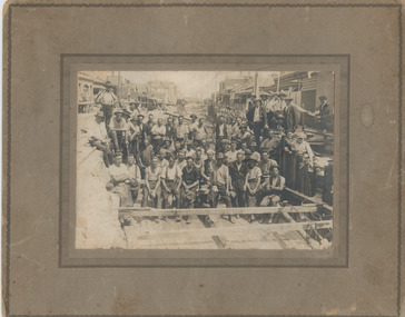
Photograph - Workers in main drain excavation, Princes Street, Port Melbourne, 1933
Given to member Jan MacDONALD by Beryl nee BROWN , whose father is one of the workers in the photo. Appears to be an original photo but an enlargement reveals it's a half- tone , so could have been copied from a publication. 'Gus' BROWN appears in third row from front 1933 photograph of construction workers in the excavation for the main drain in Princes Street. Sepia, mounted on cardboard 'frame'. Appears to be an original but is actually a halftone.Top left on back, in ink 'Kelly'princes street, engineering - board of works, engineering - canals and drainage, business and traders - hotels, sydney 'gus' brown, built environment - domestic, built environment - commercial, swallow & ariell ltd -
 Port Melbourne Historical & Preservation Society
Photograph - Photograph (digitally restored), Workers in main drain excavation, Princes Street, Port Melbourne, Appro Images, 1933
Digitally restored print of 1933 photograph of construction workers in the excavation for the main drain in Princes Street (799.01).princes street, engineering - board of works, engineering - canals and drainage, business and traders - hotels, sydney 'gus' brown, built environment - domestic, built environment - commercial, swallow & ariell ltd -
 Port Melbourne Historical & Preservation Society
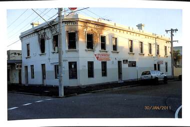
Photograph - Various Port Melbourne locations, Jack Bolt, 2011
Photographed Jan/Feb 2011 by Jack BOLTFrom a series of colour photos taken by Jack Bolt in January/February 2011 .01 - Hibernian Hotel 30.01.2011 after the second fire on 28 November 2010 .02 to .09 - Eight photos of route109 tram tracks being replaced between 29.01.2011 to 2.02.2011 (Graham St stop) .10 - view from upper floor of Woodruff Terrace .11 - air shaft Farrer & Ross Sts. Latter two photos are of work on the Melbourne Main Sewer, Ross and Bridge Streetstransport - tramways, engineering - canals and drainage, fire and fire services, hibernian hotel, jack bolt, business and traders - hotels -
Port Melbourne Historical & Preservation Society
Audio - PMHPS Meeting, Sewering Melbourne, Ann Miller, "It began at the All England Eleven", 26 May 2003
Recording of the PMHPS meeting 26.05.2003 at Cricketer's Arms Hotel. Speaker was Ann Miller on the subject "Sewering Melbourne", "It began at the All England Eleven" . Recording duration 47:22engineering - canals and drainage, ann miller, all england eleven hotel, business and traders - hotels -
 Port Melbourne Historical & Preservation Society
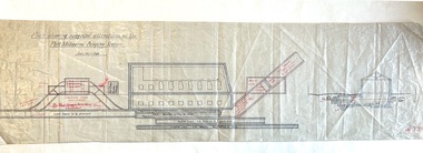
Plan - Suggested Alterations, Port Melbourne Pumping Station, Engineering Department, City of Port Melbourne
Plan showing suggested alterations to Port Melbourne Pumping Station, date unknown.engineering - canals and drainage, sandridge lagoon -
 Bendigo Military Museum
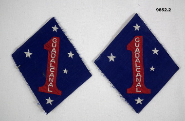
Badge - BADGES, CLOTH, GUADAL CANAL
The US 1st Marine Division Patch was created in 1943 to recognise the sacrifices and Victory of the Marines who fought in the Battle of Guadalcanal in 1942. Part of the Bennetts Collection. See Catalogue No. 9726P for details of service for "Alva Marie Bennetts".1. & 2. Diamond shaped shoulder sleeve badge. Features a red numeral 1 with 'GUADALCANAL' embroidered in white. Five white stars surround numeral. All on a blue background.bennetts collection, alva bennetts, guadalcanal, us marines -
 Royal Australian and New Zealand College of Obstetricians & Gynaecologists (RANZCOG)
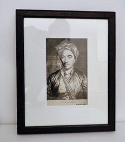
Print - Reproduction photograph of engraving of William Smellie MD, Charles Grignion (1753–1804) et al, c.1790s
William Smellie (1697-1763) was a Scottish obstetrician who primarily practised and taught in London. Smellie was groundbreaking in his understanding of childbirth and became an influential teacher of obstetrics. He diligently studied the birthing process, particularly the descent of the baby’s head down the birth canal. His observations lead to him noting that many deaths occurred because of a lack of understanding of this process and the inappropriate handling of forceps. Smellie is generally given the credit for improving the forceps to make them easier to use and less likely to damage the baby. Smellie’s "Treatise on the Theory and Practice of Midwifery" was published In 1751 and became a widely influential teaching resource. Copies of this birth atlas are held in the Frank Forster Library, RANZCOG. The RANZCOG collection also holds a set of forceps supposedly used by William Smellie.Photographic of an engraving. Image depicts a man in silken clothing, including scarf/tie and turban. The image is a head and shoulders portrait, and the subject is facing the artist. The man has stubble on his cheeks and dark coloured eyebrows. Text printed below image reads 'W.S. M.D. Aged 56'. Handwritten inscription below printed text reads 'Wm. Smellie, aged 56'. The image is mounted in white card and housed in a black wooden frame. An old display label is affixed to the bottom left hand corner of the back of the object. Handwritten inscription at centre on the back of the work reads 'John Green Room/Presented by Frank Forster, 1975'. Two hooks and a wire are attached to the back of the frame for hanging. -
 Bendigo Historical Society Inc.
Document - NEW CHUM & VICTORIA LINES OF REEF - VICTORIA REEF GOLD MINES COMPANY
Photocopied handwritten notes about the Victoria Reef Gold Mines Company. Extracts from Dickers M. Record Vol. 1 23/11/1861 Ps 2 &3. Extracts include Capital, Shares, Names of Directors and Manager, Workings, Main shaft size and depth, Cost of work and labour, Drainage, Pumping Plant and Engine House.document, gold, new chum & victoria lines of reef, victoria reef gold mines company, ballerstedt & co l l, edward cook esq, thomas burrows, henry jackson, alexander rose, david chaplin sterry, theodore ballerstedt, h b nicholas, canal basin foundry glasgow -
 Royal Australian and New Zealand College of Obstetricians & Gynaecologists (RANZCOG)
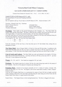
Smellie's obstetric forceps, c. 1750
William Smellie’s straight forceps are one of the most significant pairs of forceps in the Museum collection. William Smellie (1697– 1763), designed these forceps, which were an improvement on the forceps of that time. These forceps were easier to use being shorter and lighter, particularly in the handles, with pelvic curve shaped blades. He invented a locking device for the two blades. The blades were lined with leather and greased with hog’s lard for the ease of delivery and the greater comfort of the patient, this being in the era prior to an understanding of sepsis and the need for surgical hygiene.Smellie was groundbreaking in his understanding of Childbirth and became an influential teacher of Obstetrics. He diligently studied the birthing process, particularly the descent of the baby’s head down the birth canal. His observations lead to him noting that many deaths occurred because of a lack of understanding of this process and the inappropriate handling of forceps. Smellie is generally given the credit for improving the forceps to make them easier to use and less likely to damage the baby. Smellie’s "Treatise on the Theory and Practice of Midwifery" was published In 1751 and became a widely influential teaching resource. Copies of this birth atlas are held in the Frank Forster Library, RANZCOG. Smellie's obstetric forceps. Iron forceps with traces of leather on the two blades. The blades touch at the tips when the blades are fully closed. The handles have a metal sheet coating and would also have been covered in leather originally. There is a notch at the centre to lock the blades in place. Noneobstetric delivery, william smellie -
 Whitehorse Historical Society Inc.
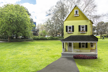
Leisure object - Dolls House, Yvonne Fitzmaurice, 1974
THE DOLL HOUSE _ Yvonne Fitzmaurice The ten room fully furnished American farmhouse was created from an idea by former Mitcham resident, Yvonne Fitzmaurice and was constructed between 1976 and 1978 as a birthday present for her daughter, Susan. The house is a unique interpretation of early American architecture and inferior design. It is also a representation of one woman's ability to create and complete a details snapshot of a lifestyle long gone and give pleasure to family, friends and now the community. Yvonne has had an interesting and full life, born in New Zealand where was a State Registered Nurse and she specialised in hospital theatre work. Later her curiosity bought her to Australia where she worked at the Sydney hospital and with the Australia Flying Doctors service flying in and out of Wilcannia, western New South Wales. On returning to New Zealand Yvonne acted as part of a Medical cover team for the different armed services. one session in the Nary involved pursuing submarines which she described as being very exciting. In 1958 she travelled by sea through the Suez Canal to England and as a member of British Services served in the post WWII Germany for three year in the QARANC and also worked at The London Clinic with some high-profile specialists. Yvonne was introduced to her husband-to-be at a tennis party and they lived in Cambridge, UK, where their two children, Alastair and Susan, were born. On coming to Australia in 1965 as "£10 poms" (Yvonne's words) she worked in casualty at the Box Hill hospital. Initially the family lived at Blackburn South before moving to Mitcham in 1968. To help establish a new life with her family in Australia, Yvonne worked in many different positions from nursing, machine knitting for a Prahran shop, making Christmas Cards and as a commercial traveller. As a hobby she also sold a number of pastel paintings. Following the publishing of her first family history in 1994, Yvonne became a member and volunteer at the Whitehorse Historical Society where she has contributed in producing local history publication, articles for the Newsletter and has improved access to the files by creating the detailed "green files". Her interests include art, crafts and writing. Yvonne has a great philosophy, 'each day I must achieve something - no matter how small'.Hand-made child's doll's house. Built by Mrs Yvonne Fitzmaurice and finished in 1979. This house was built as a 1:12 scale and is a model of a Californian house called Peppercorn farm. House was built by Yvonne and her family and took a period of three years. A lot of the furniture is handmade and the rest is collected from various shops. "Susan Fitzmaurice" name on front of building. Date on plaque on top of front wall.na5059, na5061, na5063, na5065, na5068, na5071, na5073, na5075, na5077, na5079, na5081, na5083