Showing 965 items
matching dams
-
 Kiewa Valley Historical Society
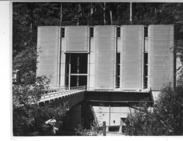
Photograph of Clover Power Station, No. 3 Power Station, after May 1944
In July, 1941 work commenced on the site of the power station with the building of a coffer dam and excavation for the power station building and machine foundations followed. Work proceeded, and the access bridge, transformer foundations and transfer track were completed in April, 1943 and the power station building in May, 1943. Installation of the machines was then proceeded with and No. 1 machine was run for the first time in June 1944. No. 2 machine was completed in April, 1944 and placed in service in May.A pictorial record for the State Electricity Commission of the first Power Station commissioned in the Kiewa Hydro Electric Scheme.Black and white photograph of the bridge and entrance to No. 3 Power Station (Clover Power Station).Handwritten on back of photograph in blue ink "No. 3 Power Station".clover, power station, machine, kiewa scheme -
 Charlton Golden Grains Museum Inc
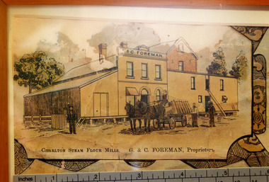
Photograph - Lithograph, Rider & Mercer, Views of Charlton
Close up photograph of part of the Charlton Lithograph showing the Charlton Steam Power Flour Mill of G & C Foreman. Located in on the bank of the Avoca river. The mill owners attempted to dam the river during the 1870s. The mill was built in 1876 as recorded by the local traveling correspondent . Foreman's flour mill established 1876 at the west end of High Street. Sold to Norske in 1925. Replaced by Noske's Flour Mill on Kays Street in 1927.Colour photo taken of a small portion of the Charlton Lithograph. Showing the Charlton Steam Flour Mill of G. C. Foreman.Charlton Steam Flour Mills. G & C Foreman proprietors.lithograph, business, industry, charlton, flour mill, noske bros, foreman -
 Federation University Historical Collection
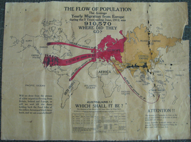
Poster, The Flow of Population, c1920
This posters advertises reasons for the migration of European (or white) people to Australia.Coloured poster on canvas showing the flow of World population around 1920 from Europe to Australia, Canada, the United States of America and South America. The poster appears to be pro the White Australia Policy with statements such as 'Will we draw from the stream of white migration from Britain, Ireland and Europe, or will we wait til the dams holding back the flood tides of the yellow, brown and black races burst, and we are overwhelmed?'migration, population, race, population statistics, migrations statistics, european immigration policy, white australia policy, racism, immigration, poster -
 Falls Creek Historical Society
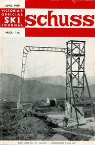
Journal - Schuss Vol. 25. No 4 June 1959
Schuss was advertised as Victoria’s Official Ski Journal It was issued monthly from 1935 to 1961 except during the war when summer issues covered two months. This continued after the war, but it averaged 10 issues annually over its 25 year life. Schuss was published by the Ski Club of Victoria which had a membership of 38 Ski Clubs and demanded to be recognised as the prime authority on skiing in the state. The other 30 ski clubs with 85% of the members disagreed and the politics of skiing became heated. These clubs formed the Federation of Victorian Ski Clubs with their own journal, Ski Horizon. With the establishment of the Victorian Ski Association, Ski-Horizon published its last issue in Nov - Dec. 1955 and the role of the official journal was fully taken over by “Schuss”. This item is significant because it contains stories, images and information documenting the development of the ski facilities at Falls Creek.The journal includes stories and events chronicling developments in Victoria and internationally. The cover features a photo of the new Federation T-Bar Lift at Mt. Buller. Page 39 included news about the completion of the Rocky Valley Dam which was now filling. It outlined safety warnings from the State Electricity Commission. It also announced the formation of a Management Committee for Falls Creek due to its growing popularity as an Alpine ski resort.schuss journal, rocky valley dam, falls creek committee of management -
 Bendigo Historical Society Inc.
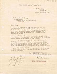
Document - MCCOLL, RANKIN AND STANISTREET COLLECTION: NELL GWYNNE MINES LETTER
Letter to J.J. Stanistreet, Legal Manager, Monument Hill Gold Mining Co., Bendigo from Nell Gwynne Mines N.L., dated 26th September 1934. Letter in connection with our request for the allotment to us of a section of the Monument Hill battery site area for use in disposal of mullock from our Nell Gwynne shaft. Mentions raising wall of existing wall of dam. Plan of the locality attached. See 2205.846.bendigo, business, nell gwynne mines n.l. -
 Darebin Parklands Association
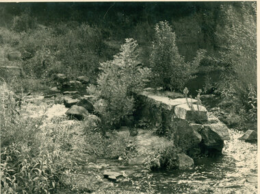
Bluestone weir, Rockbeare Park, February 1975, 1975
This bluestone weir is one of two in the same section of Darebin Creek and is a remanent from early farming days. A vineyard was established by Thomas Bear and produced award wining table wines in the 1860-70s. Orange trees were later grown on the slopes below Rockbeare Grove and mixed market gardening was established in this area as the land was progressively sub-divided and leased. The weirs were used to dam the creek and pumps used to pump water to the vineyards and orange grove.B&W photograph showing remains of bluestone weir across Darebin Creek This item and all other Darebin Parklands Association archival material is now held by State Library Victoria (Accession No: YMS 13746). Please contact State Library Victoria if access is required. -
 Bendigo Historical Society Inc.
Map - Laminated map of Lake Eppalock at full capacity
John Perry Collection. Laminated copy of map of Lake Eppalock at full capacity. Had highlighter markings of old roads which appear to be still in use. The dam was built by the State Rivers and Water Supply Commission of Victoria. The dam wall height is 45 metres (148 ft) and the main embankment is 1,041 metres (3,415 ft) long. At 100% capacity the dam wall was designed to hold back 304,651 megalitres (6.7014×10¹⁰ imp gal; 8.0480×10¹⁰ US gal) of water. The surface area of Lake Eppalock is 3,011 hectares (7,440 acres) and the catchment area is 2,124 square kilometres (820 sq mi). The controlled spillway is capable of discharging 8,040 cubic metres per second (284,000 cu ft/s). Lake Eppalock supplies both stock and domestic water to the Campaspe irrigation district. It also serves as a water supply to Bendigo and Heathcote and, in more recent times, Ballarat. The lake is a major attraction for those engaging in watersports, with a number of tourist parks and accommodation facilities available. Permissible activities on the lake include high-speed boating, water skiing, sailing, canoeing, fishing and swimming. The lake's water levels were low for approximately eight years between 2002 and 2010 during a prolonged drought, which restricted the amount of recreational activity until rainfall in the latter half of 2010 returned the lake to 100 percent capacity. Built between 1961 and 1964, Lake Eppalock remains the only water storage on the Campaspe River system.map, water, dam, reservoir, eppalock -
 Bendigo Historical Society Inc.
Map - Laminated worksheet - identification of inundated artifacts at Lake Eppalock
John Perry Collection. Laminated copy of worksheet identifying inundated artifacts at Lake Eppalock when at 10% capacity. The dam was built by the State Rivers and Water Supply Commission of Victoria. The dam wall height is 45 metres (148 ft) and the main embankment is 1,041 metres (3,415 ft) long. At 100% capacity the dam wall was designed to hold back 304,651 megalitres (6.7014×10¹⁰ imp gal; 8.0480×10¹⁰ US gal) of water. The surface area of Lake Eppalock is 3,011 hectares (7,440 acres) and the catchment area is 2,124 square kilometres (820 sq mi). The controlled spillway is capable of discharging 8,040 cubic metres per second (284,000 cu ft/s). Lake Eppalock supplies both stock and domestic water to the Campaspe irrigation district. It also serves as a water supply to Bendigo and Heathcote and, in more recent times, Ballarat. The lake is a major attraction for those engaging in watersports, with a number of tourist parks and accommodation facilities available. Permissible activities on the lake include high-speed boating, water skiing, sailing, canoeing, fishing and swimming. The lake's water levels were low for approximately eight years between 2002 and 2010 during a prolonged drought, which restricted the amount of recreational activity until rainfall in the latter half of 2010 returned the lake to 100 percent capacity. Built between 1961 and 1964, Lake Eppalock remains the only water storage on the Campaspe River system.map, artifacts, eppalock, reservoir -
 Bendigo Historical Society Inc.
Map - Black and white map pertaining to Lake Eppalock
John Perry Collection. Laminated copy of map pertaining to Lake Eppalock. Gives details of dwellings, bridges and ford crossings. The dam was built by the State Rivers and Water Supply Commission of Victoria. The dam wall height is 45 metres (148 ft) and the main embankment is 1,041 metres (3,415 ft) long. At 100% capacity the dam wall was designed to hold back 304,651 megalitres (6.7014×10¹⁰ imp gal; 8.0480×10¹⁰ US gal) of water. The surface area of Lake Eppalock is 3,011 hectares (7,440 acres) and the catchment area is 2,124 square kilometres (820 sq mi). The controlled spillway is capable of discharging 8,040 cubic metres per second (284,000 cu ft/s). Lake Eppalock supplies both stock and domestic water to the Campaspe irrigation district. It also serves as a water supply to Bendigo and Heathcote and, in more recent times, Ballarat. The lake is a major attraction for those engaging in watersports, with a number of tourist parks and accommodation facilities available. Permissible activities on the lake include high-speed boating, water skiing, sailing, canoeing, fishing and swimming. The lake's water levels were low for approximately eight years between 2002 and 2010 during a prolonged drought, which restricted the amount of recreational activity until rainfall in the latter half of 2010 returned the lake to 100 percent capacity. Built between 1961 and 1964, Lake Eppalock remains the only water storage on the Campaspe River system.eppalock, map, water, dam, reservoir -
 Bendigo Historical Society Inc.
Map - Map of overlay of lake Eppalock at full capacity. Map 'C'
John Perry collection. Map 'C'. Laminated map of overlay of Lake Eppalock at full capacity. Circa 1951. The dam was built by the State Rivers and Water Supply Commission of Victoria. The dam wall height is 45 metres (148 ft) and the main embankment is 1,041 metres (3,415 ft) long. At 100% capacity the dam wall was designed to hold back 304,651 megalitres (6.7014×10¹⁰ imp gal; 8.0480×10¹⁰ US gal) of water. The surface area of Lake Eppalock is 3,011 hectares (7,440 acres) and the catchment area is 2,124 square kilometres (820 sq mi). The controlled spillway is capable of discharging 8,040 cubic metres per second (284,000 cu ft/s). Lake Eppalock supplies both stock and domestic water to the Campaspe irrigation district. It also serves as a water supply to Bendigo and Heathcote and, in more recent times, Ballarat. The lake is a major attraction for those engaging in watersports, with a number of tourist parks and accommodation facilities available. Permissible activities on the lake include high-speed boating, water skiing, sailing, canoeing, fishing and swimming. The lake's water levels were low for approximately eight years between 2002 and 2010 during a prolonged drought, which restricted the amount of recreational activity until rainfall in the latter half of 2010 returned the lake to 100 percent capacity. Built between 1961 and 1964, Lake Eppalock remains the only water storage on the Campaspe River system.map, water, eppalock, dam, reservoir -
 Bendigo Historical Society Inc.
Map - Laminated map of Lake Eppalock empty. Map 'D'
John Perry Collection. Laminated map of Lake Eppalock empty. Map 'D'. Circa 1951. The dam was built by the State Rivers and Water Supply Commission of Victoria. The dam wall height is 45 metres (148 ft) and the main embankment is 1,041 metres (3,415 ft) long. At 100% capacity the dam wall was designed to hold back 304,651 megalitres (6.7014×10¹⁰ imp gal; 8.0480×10¹⁰ US gal) of water. The surface area of Lake Eppalock is 3,011 hectares (7,440 acres) and the catchment area is 2,124 square kilometres (820 sq mi). The controlled spillway is capable of discharging 8,040 cubic metres per second (284,000 cu ft/s). Lake Eppalock supplies both stock and domestic water to the Campaspe irrigation district. It also serves as a water supply to Bendigo and Heathcote and, in more recent times, Ballarat. The lake is a major attraction for those engaging in watersports, with a number of tourist parks and accommodation facilities available. Permissible activities on the lake include high-speed boating, water skiing, sailing, canoeing, fishing and swimming. The lake's water levels were low for approximately eight years between 2002 and 2010 during a prolonged drought, which restricted the amount of recreational activity until rainfall in the latter half of 2010 returned the lake to 100 percent capacity. Built between 1961 and 1964, Lake Eppalock remains the only water storage on the Campaspe River system.map, water, dam, reservoir, eppalock -
 Bendigo Historical Society Inc.
Document - Legend to maps A, B and C for Lake Eppalock
John Perry Collection. Laminated 'legend' for Maps A, B and C for Lake Eppalock also in this collection. Black and White definitions and descriptions of objects and markers found on maps. Circa 1951. The dam was built by the State Rivers and Water Supply Commission of Victoria. The dam wall height is 45 metres (148 ft) and the main embankment is 1,041 metres (3,415 ft) long. At 100% capacity the dam wall was designed to hold back 304,651 megalitres (6.7014×10¹⁰ imp gal; 8.0480×10¹⁰ US gal) of water. The surface area of Lake Eppalock is 3,011 hectares (7,440 acres) and the catchment area is 2,124 square kilometres (820 sq mi). The controlled spillway is capable of discharging 8,040 cubic metres per second (284,000 cu ft/s). Lake Eppalock supplies both stock and domestic water to the Campaspe irrigation district. It also serves as a water supply to Bendigo and Heathcote and, in more recent times, Ballarat. The lake is a major attraction for those engaging in watersports, with a number of tourist parks and accommodation facilities available. Permissible activities on the lake include high-speed boating, water skiing, sailing, canoeing, fishing and swimming. The lake's water levels were low for approximately eight years between 2002 and 2010 during a prolonged drought, which restricted the amount of recreational activity until rainfall in the latter half of 2010 returned the lake to 100 percent capacity. Built between 1961 and 1964, Lake Eppalock remains the only water storage on the Campaspe River system.map, water, dam, reservoir, eppalock -
 Bendigo Historical Society Inc.
Document - Collection of photographs from newspaper on a single page
John Perry Collection. Laminated copy of page from 'Weekly Times' newspaper, February, 1962. Nine images relating to establishing and building Eppalock Reservoir, 15 miles from Bendigo. The dam was built by the State Rivers and Water Supply Commission of Victoria. The dam wall height is 45 metres (148 ft) and the main embankment is 1,041 metres (3,415 ft) long. At 100% capacity the dam wall was designed to hold back 304,651 megalitres (6.7014×10¹⁰ imp gal; 8.0480×10¹⁰ US gal) of water. The surface area of Lake Eppalock is 3,011 hectares (7,440 acres) and the catchment area is 2,124 square kilometres (820 sq mi). The controlled spillway is capable of discharging 8,040 cubic metres per second (284,000 cu ft/s). Lake Eppalock supplies both stock and domestic water to the Campaspe irrigation district. It also serves as a water supply to Bendigo and Heathcote and, in more recent times, Ballarat. The lake is a major attraction for those engaging in watersports, with a number of tourist parks and accommodation facilities available. Permissible activities on the lake include high-speed boating, water skiing, sailing, canoeing, fishing and swimming. The lake's water levels were low for approximately eight years between 2002 and 2010 during a prolonged drought, which restricted the amount of recreational activity until rainfall in the latter half of 2010 returned the lake to 100 percent capacity. Built between 1961 and 1964, Lake Eppalock remains the only water storage on the Campaspe River system. dam, engineering, water, eppalock -
 Bendigo Historical Society Inc.
Map - Black and White map. Outline of Lake Eppalock. Map 'B'
John Perry Collection. Laminated copy black and white map. Map 'B'. Outline of Lake Eppalcok, overlayed on map. Circa 1951. The dam was built by the State Rivers and Water Supply Commission of Victoria. The dam wall height is 45 metres (148 ft) and the main embankment is 1,041 metres (3,415 ft) long. At 100% capacity the dam wall was designed to hold back 304,651 megalitres (6.7014×10¹⁰ imp gal; 8.0480×10¹⁰ US gal) of water. The surface area of Lake Eppalock is 3,011 hectares (7,440 acres) and the catchment area is 2,124 square kilometres (820 sq mi). The controlled spillway is capable of discharging 8,040 cubic metres per second (284,000 cu ft/s). Lake Eppalock supplies both stock and domestic water to the Campaspe irrigation district. It also serves as a water supply to Bendigo and Heathcote and, in more recent times, Ballarat. The lake is a major attraction for those engaging in watersports, with a number of tourist parks and accommodation facilities available. Permissible activities on the lake include high-speed boating, water skiing, sailing, canoeing, fishing and swimming. The lake's water levels were low for approximately eight years between 2002 and 2010 during a prolonged drought, which restricted the amount of recreational activity until rainfall in the latter half of 2010 returned the lake to 100 percent capacity. Built between 1961 and 1964, Lake Eppalock remains the only water storage on the Campaspe River system.map, water, dam, reservoir, eppalock -
 Bendigo Historical Society Inc.
Map - Black and white map pertaining to Lake Eppalock
John Perry Collection. Laminated copy of map relating to Lake Eppalock. Lists dwellings, ford crossings and bridges. The dam was built by the State Rivers and Water Supply Commission of Victoria. The dam wall height is 45 metres (148 ft) and the main embankment is 1,041 metres (3,415 ft) long. At 100% capacity the dam wall was designed to hold back 304,651 megalitres (6.7014×10¹⁰ imp gal; 8.0480×10¹⁰ US gal) of water. The surface area of Lake Eppalock is 3,011 hectares (7,440 acres) and the catchment area is 2,124 square kilometres (820 sq mi). The controlled spillway is capable of discharging 8,040 cubic metres per second (284,000 cu ft/s). Lake Eppalock supplies both stock and domestic water to the Campaspe irrigation district. It also serves as a water supply to Bendigo and Heathcote and, in more recent times, Ballarat. The lake is a major attraction for those engaging in watersports, with a number of tourist parks and accommodation facilities available. Permissible activities on the lake include high-speed boating, water skiing, sailing, canoeing, fishing and swimming. The lake's water levels were low for approximately eight years between 2002 and 2010 during a prolonged drought, which restricted the amount of recreational activity until rainfall in the latter half of 2010 returned the lake to 100 percent capacity. Built between 1961 and 1964, Lake Eppalock remains the only water storage on the Campaspe River system.map, water, dam, reservoir, eppalock -
 Bendigo Historical Society Inc.
Map - General view of area of proposed construction of Lake Eppalock. Map 'A'
John Perry Collection. Laminated map of proposed construction of Lake Eppalock. Map 'A'. Black and white map in laminate. Circa 1951. The dam was built by the State Rivers and Water Supply Commission of Victoria. The dam wall height is 45 metres (148 ft) and the main embankment is 1,041 metres (3,415 ft) long. At 100% capacity the dam wall was designed to hold back 304,651 megalitres (6.7014×10¹⁰ imp gal; 8.0480×10¹⁰ US gal) of water. The surface area of Lake Eppalock is 3,011 hectares (7,440 acres) and the catchment area is 2,124 square kilometres (820 sq mi). The controlled spillway is capable of discharging 8,040 cubic metres per second (284,000 cu ft/s). Lake Eppalock supplies both stock and domestic water to the Campaspe irrigation district. It also serves as a water supply to Bendigo and Heathcote and, in more recent times, Ballarat. The lake is a major attraction for those engaging in watersports, with a number of tourist parks and accommodation facilities available. Permissible activities on the lake include high-speed boating, water skiing, sailing, canoeing, fishing and swimming. The lake's water levels were low for approximately eight years between 2002 and 2010 during a prolonged drought, which restricted the amount of recreational activity until rainfall in the latter half of 2010 returned the lake to 100 percent capacity. Built between 1961 and 1964, Lake Eppalock remains the only water storage on the Campaspe River system.map, dam, water, weir, eppalock -
 Eltham District Historical Society Inc
Work on paper (item) - Photograph, 2 Metery Road, Eltham South
Robert and Ada Zull built an Alistair Knox designed house at 2 (lot 8) Metery Road, Eltham, a one acre property for their family of five in the mid 1960s. The form of the house is laid out on the cleared block. There was a dam at the bottom of the block. Susan Bennett, nee Zull's reminiscences are published in EDHS Newsletter, February and April 2020. ".. the block was big.. Building the house was slow going. The plans had to be discussed, then drawn up, finance found, council permits obtained and labourers engaged. " This series of photographs together with the account of personal remiscences provide a unique document of the construction of an Alistair Knox designed home. Knox was a pioneer in the use of mudbricks and recycled materials and is significant to his contribution of this style of architecture in Eltham and the wider Shire of Nillumbik.zull family, clearing, eltham south, 2 metery road, alistair knox, bow and arrow -
 Kiewa Valley Historical Society
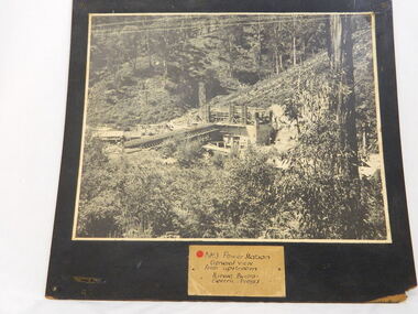
Photo of No. 3 Power Station at Kiewa Hydro Electric Scheme, No. 3 Power Station at Kiewa Hydro Electric Scheme
The State Electricity Commission of Victoria were the employers of the Kiewa Hydro Scheme. The work included building dams, power stations and the infrastructure for the work and their employees. Mt Beauty and Bogong village were the places where this scheme was built and where this photo shows part of its construction being Power Station 3. Originally there were 3 Hydro stations built from the 1930's onwards. The scheme finished being built in 1960 and is the biggest Hydro electricity scheme in Victoria. This photo has good Historic significance: The construction of No. 3 Power Station which was part of the Kiewa Hydro Electric Scheme built by the State Electricity Commission of Victoria. Therefore is picture is very historically significant as it shows the power station at the time of its construction which is an important part of Victoria' development and history. Since Mt Beauty was established due to the Hydro scheme being built this photo has great interpretation capacity. This is a black and white photograph showing the power station and workmen's huts and storage huts, site manager's office and surrounding bush. The photo is mounted on black painted 3 ply board. no.3 power station. kiewa hydro electric scheme. s.e.c.v..electricity. -
 Kiewa Valley Historical Society
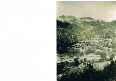
Photograph Bogong Township, Bogong Township Circa 1940s right side view, circa 1950
The Bogong Township (circa 1930s) was constructed by The State Electricity Commission of Victoria as a base camp for construction workers under the Kiewa Hydroelectric Scheme starting in 1938. The Scheme employed 4000 men during its construction phase. A small number were first housed at Bogong Village and when required the Mount Beauty Township was established(1949). Construction at the dams and Power Stations was interrupted during World War II. June 1951 started construction at full pace. The Bogong Township was developed firstly as an accommodation centre (base camp) for construction workers employed under the Kiewa Hydroelectric Scheme. Due to the influx of European workers into the Township the beautification of the immediate surrounds(gardens etc.) had a distinct European flavour. This environment has been very beneficial for tourism in later years. Strict environmental control has not allowed for any extensive redevelopment in tourist accommodation and basically restricted it to the accommodation initially built for the construction workers. Activities such a bike riding, snow skiing, restricted horse riding and bush walking on the Alpine plains and mountains are now a viable part of the Kiewa Valley Tourist Industry.Scanned copy of original black and white photo. Paper manufacturer is Kodak. Paper is Kodak XtraLife II.On reverse side "Kodak ExtaLife II paper"bogong village, bogong township, sec alpine constructions, victorian alpine tourism, winter sports. -
 Orbost & District Historical Society
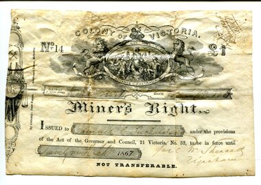
Certificate, September 1867
Following a Royal Commission in 1855, the Gold License was changed to the Miner’s Right, which reduced the fee and required annual payment, rather than monthly or quarterly.The fourth Goldfields Act, passed in early 1858, gave increased privileges to holders of Miner's Rights. These included the right to make residential claims, allowing the cutting of timber on claims and giving the right to build races and dams on any crown lands for mining purposes. This certificate is in the name of Samuel Richardson who brought it to Orbost.This item is of historical significance as it is associated with positive outcomes for gold miners brought about by the Eureka Stockade rebellion and its subsequent democrat changes. It is also associated with the Richardsonfamily who were early settlers in Orbost.A certificate for a miner's right printed on paper. It cost one pound. It was Not Transferable. Details have been filled out in ink. At the top of the licence is an elaborate etching, under the heading 'Colony of Victoria'. Inside a shield is a young woman, crowned, seated, with shipping in the background. oO her left is a miner with hat presenting her with a gold nugget while on her right, a farmer presents grain to her. Mottoes include 'Honi Soit Que Mal Y Pense'; 'Dieu et Mon Droit' and 'Advance Australia' There are handwritten notes in faded ink on the back.miner's right, colony of victoria, samuel richardson, no 14, government act -
 Stawell Historical Society Inc
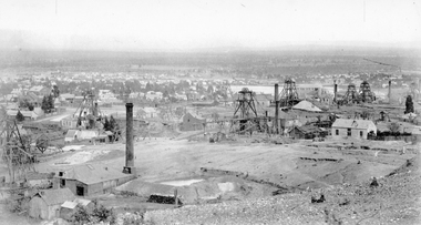
Photograph, Panorama Of Stawell from Big Hill looking North West 1878 Mines Visible
On very left behind the winding engine shed in the foreground is the South Cross Mines No8 & No9. The next mine to the right not counting the Whims is the Crown Cross United Mine with curved tramway. Tyne Reefing Company is barely visible at centre of image in front of left end of settling dam. The Great Northern is centre right of image, Extended Cross Reef Mine, then Oriental Mine, the Grant Lamont Battery and two Pleasant Creek Cross Reef Poppet Heads.Scotchmans United Quarts Mining Company 1878Victorian Views. C. Herbert, Photo. Stawell 1878stawell mining -
 Kiewa Valley Historical Society
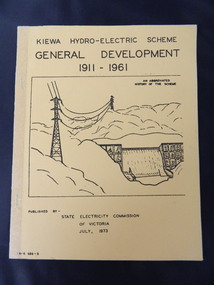
Book - Kiewa Hydro Electric Scheme 1911-1961, Kiewa Hydro-Electric Scheme /General Development / 1911-1961, July, 1973
The book is an abbreviated history of the Kiewa Hydro Electric Scheme.This book summarises the stages of the Kiewa Hydro Electric Scheme from its conception in 1911 through to 1961. The newspaper cutting gives additional information about Rocky Valley Dam.Yellow cardboard book with front cover of black writing and sketch of power lines and spillway in the mountains. 2 staples are covered along the spine with tape. There are 22 pages. 2 copies Inside one copy there is a newspaper cutting entitled "Main Dam in Kiewa Scheme Finished" and later published pages of 1. Floras of Bogong 2. Geology of Kiewa Area 3. Fauna and 4. 'Brief history of the Kiewa Scheme. An abbreviated History of the SchemeOn the newspaper cutting hand written "Burnett 1959 Later than May."kiewa hydro electric scheme. mt beauty. dederang. bogong. mckay creek power station. west kiewa power station. clover power station. secv. rocky valley dam. flora. fauna. geology. -
 Bendigo Historical Society Inc.
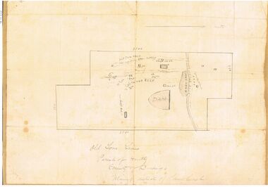
Map - OLD TOM MINE, WHIPSTICK
2 copies ( A4 and A3) of Old Tom lease. Map shows Old Tom Reef, old working open cutting, shaft 150 ft., Easter Reef, dam sand heap, water race, 3 other shafts, 120ft., 90ft., and 500 ft. marked on map. Stamped on map '64.3.34' Written on bottom of map in handwriting ' Old Tom Lease, Parish of Huntly, County of Bendigo, Mining district of Sandhurst'bendigo, mining, old tom lease map -
 Bendigo Historical Society Inc.
Book - ENGINEERING CHALLENGES IN 19TH CENTURY VICTORIA
Engineering Challenges in 19th Century Victoria by Brian C S Harper, or Brian Harper, soft cover 256 pages with black and white photographs. Book includes information on the construction of the Bendigo Railway Line, Coliban Water Scheme, Lower Stony Creek Dam, the Saltwater Railway Bridge, and the Taradale Railway Viaduct. Transferred to Specimen Cottage for use June 2016 Missing from Specimen Cottage. Check sale items 8.12.22Brian C. S. Harperbooks, technical, engineering -
 Bendigo Historical Society Inc.
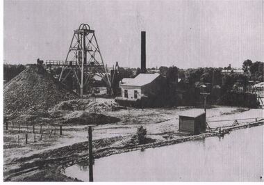
Photograph - BLACK AND WHITE PHOTOGRAPH OF THE NORTH DEBORAH MINE
North Deborah Mine in Eve Street, Bendigo, operated between 1937 and 1954. In that time it produced 128,000 ounces of gold.Black and white photograph of the North Deborah Mine, showing the poppet head, mullock heap to the left, man at the end of railway at the first level, does not show cables from the engine house to the wheels on top of the poppet, water tank at the side of the engine house, farm style corner of a fence at left of photo, small shed housing a pump for water, right foreground is a dam for water waiting to be converted to steam to operate the cable winder.mining, surface equipment, north deborah mine -
 Bendigo Historical Society Inc.
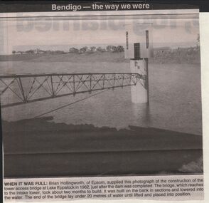
Newspaper - JENNY FOLEY COLLECTION: WHEN IT WAS FULL
BHS CollectionBendigo advertiser ''The way we were'' from 2003. When it was full: Brian Hollingworth of Epsom, supplied this photograph of the construction of the tower access bridge at lake Eppalock in 1962, just after the dam was completed. The bridge, which reaches to the intake tower, took about two months to build. It was built on the bank in sections and lowered into the water. The end of the bridge lay under 20 metres of water until lifted and placed into position. The clip is in a folder.newspaper, bendigo advertiser, the way we were -
 Bendigo Historical Society Inc.
Newspaper - AUSTIN COLLECTION: Koch's Pioneer Gold Mine, Long Gully
Koch's Pioneer Quartz Mining and Crushing Company was officially registered on June 30th., 1871 (Government Gazette No. 45, 1871). It operated at Long Gully, the first Manager was Andrew Lewis. Nominal capital was 90,000 pounds in thirty thousand shares of 3 pounds each. The initial partnership in a quartz crushing plant between Henry Koch, Simon Albert and Charles Wallin was dissolved in 1860 with Koch becoming the sole owner. In 1866 the crushing plant consisted of a 50 hp engine and 48 stamping heads capable of crushing 600 tons of quartz per week. By 1902 there were 72 stamps and this was by far the largest crushing plant in the area, serving many quartz mines. Henry Koch (1800-1889) was a German sailor who signed off when his ship reached Melbourne in 1851. Having heard of the gold discovery he proceeded to Bendigo where he was initially employed in puddling in the Myers Flat area. He was soon employed and then made partner in a quartz crushing plant that he became sole owner of in 1860. He was also landlord at the British and American Hotel and the Silver Mines Hotel. HE also started the Perseverance United gold claim. He married Anna Maria Theresia Heinz in 1857. In 1872 he sold the crushing plant for 75,000 pounds and took his family back to Germany. He resumed his trade as a ship builder although he maintained many Bendigo mining interests.Two sepia coloured images on paper, possibly taken from book. Top image: Koch's 'Pioneer' Quartz Crushing Works - Long Gully, printed under image. Image shows mining dam in foreground, large two storey mine building in middle background, two mine chimney on right hand side. Bottom image; interior of crushing battery. Printed on bottom ' Quartz Crushing Batteries & etc. Koch's Pioneer'. gold mining, koch's pioneer crushing battery, long gully, perseverance g.m. co., henry koch -
 Federation University Historical Collection
Book, McGraw-Hill Book Company, Hydraulics: A Text on Practical Fluid Mechanics, 1937
The book was used by Charles Bacon who studied at the University of Nevada in the late 1930s/early 1940s. Bacon worked at Bunker Hill Mines and Kellogg Idaho, before arriving in Australian in 1951. He worked for CN Myers, a company involved with paper converting. CN Myers was a family business (on Charles Bacon's maternal line).Blue hard-covered book of 460 pages. Chapters include Properties of Fluids, intensity of Pressure, Hydrostatic Pressure of Areas, Dams, Kinematics of fluid Flow, Dynamics of Fluid Flow, Applications of Hydrokinetics, Friction Losses in Pipes, Flow Through Pipes, Uniform Flow in Open Channels. Nonuniform Flow in Open Channels, Unsteady Flow, Dynamic Forces, Description of the Impulse Wheel, Theory of the Impulse Wheel, water Power Plants, centrifugal Pump and more.Inside Front Cover "Charles Bacon, Mackay school of Mines Reno, Nevada."charles bacon, mining engineering, metallurgy, university of nevada, mackay school of mines -
 Bendigo Historical Society Inc.
Document - STATE RIVERS AND WATER SUPPLY COMMISSION : GENERAL DESCRIPTION AND PARTICULARS OF EPPALOCK PROJECT, 1/08/1961
State Rivers and Water Supply Commission. Seven-page typed document titled 'General description and particulars of the Eppalock Project.' Subheadings: General, Administration and Works Installation, Field laboratory, Construction programme, Design statistics, Major items of plant in use on the project, Progress to 1st August 1961, Eppalock Reservoir Locality Plan (diagram), Eppalock project works area & arrangement plan (diagram), Eppalock Project cross section of dam along? tunnel (diagram).state infrastructure, water supply, coliban system, state rivers and water supply commission. coliban system. eppalock. -
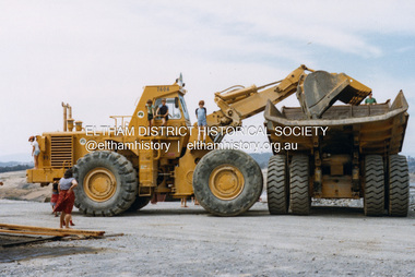 Eltham District Historical Society Inc
Photograph - Colour Print, Lewis Tulk, Construction Winneke Reservoir and treatment plant / Melbourne and Metropolitan Board of Works, c.1981
Sugarloaf Reservoir is situated on former farmland. This large water storage was completed in 1982 and serves Melbourne's northern suburbs. Within the visitor areas are two picnic grounds and other recreational facilities. Below its massive rock embankment is located the Winnecke Treatment Plan designed to purify its water before being piped into Melbourne. The dam partly inundated the old firing ranges of the former Christmas Hills Rifle Club. Source: Christmas Hills Now and then: Yarra Glen & District Historical Society, 2004.lewis tulk collection, construction, sugarloaf reservoir, winnecke dam