Showing 1947 items matching " flooding"
-
 Eltham District Historical Society Inc
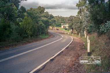
Photograph, Kangaroo Ground-Warrandyte Road, Kangaroo Ground, c.1988, 1988c
Looking southeast, Floods Road on right adjacent to bus stop.Roll of 35mm colour negative film, 7 stripsFuji 100eltham shire council, infrastructure, kangaroo ground-warrandyte road, kangaroo ground -
 Tatura Irrigation & Wartime Camps Museum
Document, Our Saleyards War, 1950
Humorus poems regarding moving of saleyards in Tatura and reference to floods2 Humorous Poems and letter to the Editor (1950) copied from Tatura Guardianour saleyards war, local poems, letter, tatura, document, newspaper -
 Tatura Irrigation & Wartime Camps Museum
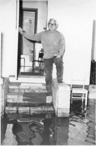
Photograph, Dosser, Bob
Dosser, Bob. Standing at his back door during floods. -
 Stawell Historical Society Inc
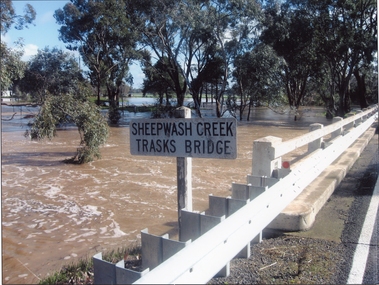
Photograph, Trasks Bridge at Sheepwash Creek at Campbells Bridge in flood 2011
Trasks Bridge Sheepwash Creek at Campbells Bridge in flood 2011.stawell shire -
 Eltham District Historical Society Inc
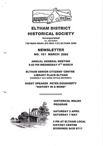
Newsletter, Newsletter, No. 161 March 2005
Contents: • Next meeting, guest speaker; Peter Dougherty: History in a Word • Annual General Meeting • Peter Dougherty • February Meeting and the Flood Connection • Art Streams • The 1934 Floods at Eltham by Harold Bird • Nillumbik Combined History Groups • What Else? The Shire of Eltham Historical Society was formed in October 1967. The first newsletter of the Society was issued May 1978 and has been published continuously ever since on a bi-monthly basis. With the cessation of the Shire of Eltham in late 1994, the Society's name was revised to Eltham District Historical Society and this name first appeared with issue No. 103, July 1995. The collection of the Society's newsletters provides a valuable resource on the history of the Society's activities, office bearers and committee members, guest speakers and subjects of historical interest pertinent to the former Shire of Eltham and the Eltham District.A4 photocopied newsletter distributed to membersnewsletter, eltham district historical society, shire of eltham historical society -
 Kew Historical Society Inc
Photograph - Yarra in Flood - Belford & Kilby Farms, 1903
The Yarra Valley in what was previously called North Kew, but is now East Kew, was frequently subjected to flooding. Apart from some development on higher ground, the City of Kew regularly introduced restrictions on development and the building of housing in the area because of flood levels. Panoramic photographic positive of North Kew where the Belford and Kilby Farms were located on the south side of the Yarra River. This photo is a copy of the original photo in the collection.floods -- yarra -- 1903, kew golf course, greenacres golf course -
 Orbost & District Historical Society
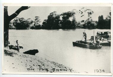
black and white photograph, 1934
This photograph shows vehicles and people being ferried across the Snowy River during the 1934 flood. The Orbost punt was reinstated on a temporary basis following damage to the bridge. Damage estimated at £500,000 was caused by the 1934 floods in the Orbost district. This 1934 flood was devastating, destroying a section of the 1922 Orbost bridge, wrecking fences, bridges and roads, dumping silt and debris on the rich river flats and drowning cattle. The centre span of the Orbost Bridge was washed away.This is a pictorial record of the effects of the 1934 floods in the Orbost district.A large black / white photograph of a punt with a motor vehicle and people making their way across a river.on front - "On the Snowy 1934"snowy-river-orbost flood-1934 river-transport-punt -
 Eltham District Historical Society Inc
Album - Photograph, J.A. McDonald, Eltham-Yarra Glen Road, 3 Aug. 1956
Floods at Yarra Glen November, 1956 From top of Grand HotelRecord of various Shire of Eltham infrastructure works undertaken during the period of 1952-1962 involving bridge and road reconstruction projects, sometimes with Eltham Shire Council Project Reference numbers quoted. It was during this period that a number of significant improvements were made to roads and new bridges constructed within the shire that remain in place as of present day (2022). In many situations, the photos provide a tangible visible record of infrastructure that existed throughout the early days of the Shire. The album was put together by or under the direction of the Shire Engineer, J.A. McDonald.infrastructure, road construction, shire of eltham, bridge construction, eltham-yarra glen road, 1956-11, floods, floodwater, ford service garage, grand hotel, new holland, yarra glen -
 Greensborough Historical Society
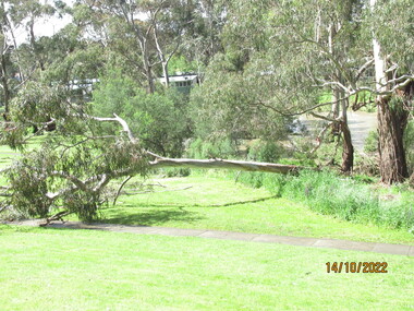
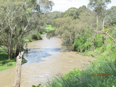
Photograph - Photograph - Digital Image, Peter Simmenauer, Plenty River floods near Plenty Lane 2022, 14/10/2022
Plenty River in flood near Plenty Lane Greensborough, October 2022. Colour digital photographDate stamped: 14/10/2022plenty lane greensborough, plenty river, floods -
 Greensborough Historical Society
Slide - Photograph, John Ramsdale, Plenty River flood plain: Slide 95, 1990s
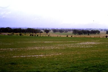
Photograph shows water over paddocks; Plenty River flood plain.Part of the John Ramsdale collection of slides and audio visual material.Colour photograph scanned from slide.No maker's marks. No caption on slide.plenty river, plenty river flood -
 Greensborough Historical Society
Slide - Photograph, John Ramsdale, Flood plain of the Plenty River: Slide 90, 1990s
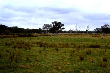
Photograph shows farmland on the flood plain of the Plenty River, north of MerndaPart of the John Ramsdale collection of slides and audio visual material.Colour photograph scanned from slide.No maker's marks. Caption on slide "Plenty"plenty river, mernda -
 Greensborough Historical Society
Photograph - Digital image, Plenty River in Flood 2017: Graffiti, 14/12/2017
Photograph of graffiti on the Plenty River bridge, Greensborough. This flood was in December 2017.Digital copy of colour photograph.plenty river, floods, graffiti -
 Greensborough Historical Society
Photograph - Photograph - Digital Image, Peter Simmenauer, Plenty River floods near Plenty Lane 2022, 14/10/2022
Plenty River in flood near Plenty Lane October 2022 Greensborough. Colour digital photographDate stamped: 14/10/2022plenty lane greensborough, plenty river, floods -
 Bendigo Historical Society Inc.
Photograph - BERT GRAHAM COLLECTION: TOM FLOOD, MRS POWELL
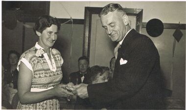
Black & white photograph, Bert Graham Collection, Tom Flood is presenting something to Mrs. Powell. Names on the back also Reorder o. B35/11. Kiwi Candid Photos Town Hall Pharmacy, 226 Hargreaves St., Bendigo. Phone 1467.bendigo, clubs, bendigo east progress carpet bowls -
 Bendigo Historical Society Inc.
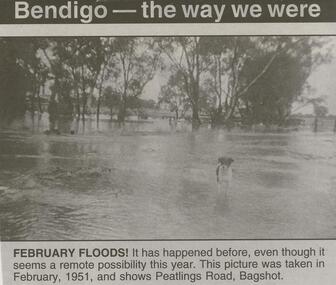
Newspaper - JENNY FOLEY COLLECTION: FEBRUARY FLOODS
BHS CollectionBendigo Advertiser ''The way we were'' from Friday, February 6, 2004. February floods: it has happened before, even tough it seems a remote possibility this year. This picture was taken in February, 1951, and shows Peatlings Road, Bagshot. The clip is in a folder.newspaper, bendigo advertiser, the way we were -
 Lakes Entrance Historical Society
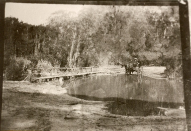
Photograph - Bridges, 1910
Also black and white identical copy 10 x 15 cm, donated by Marion Holding. 02288.1Sepia toned photograph of the old road crossing at Bunga Creek, between Lake Tyers and Lakes Entrance. It shows a rustic footbridge over waterway beside flooded road, horse and buggy with man and woman on board at edge of water. Lakes Entrance Victoriabridges, waterways -
University of Melbourne, Burnley Campus Archives
Plan, Swinburne College of Technology Ltd. Detail Survey of Willsmere Park, 1978-c.1987
Plan dated 27.10.1978 for Swinburne College of Technology Ltd. With updated handwritten notes post 1978, imcluding 1987 flood level, by T.Smith, B. Jones, B.S. Ooi, D.Ong. Photocopy of page from Melways street directory showing location of parkswinburne college of technology, willsmere park, t.smith, b. jones, b.s. ooi, d.ong, kew east -
 Lakes Entrance Historical Society
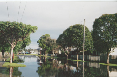
Photograph, Bulmer Street in flood Lakes Entrance Victoria, 2004 c
Colour photograph showing flood water in Bulmer Street looking south towards the Cunninghame Arm Lakes Entrance Victoria. Also second colour photograph taken at same time plus another of a house under construction following a mini tornado in 2005floods, naturalm disasters, township -
 Bendigo Historical Society Inc.
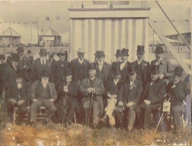
Photograph - M. ROSE COLLECTION: BENDIGO AGRICULTURAL AND HORTICULTURAL SHOW SOCIETY, circa 1905
The Bendigo Horticultural and Agricultural Show began in 1859 when a meeting was held at the Shamrock hotel to form a committee. The first competitive event was a ploughing competition held at Lockwood in June 1859.Photograph - black and white. A group of men, sitting and standing in the Bendigo Showgrounds (now known as Tom Flood Centre) looking South. On the 30th Nov.2001 James Lerk gave his opinion that the above is correct. Bendigo Agricultural and Horticultural Show Society.organization, club/society, agricultural and horticultural show, bendigo agricultural and horticultural show. -
 Kew Historical Society Inc
Postcard - Zig-Zag Bridge
Sepia postcard of the Zig-Zag Bridge at Kew. The bridge was constructed in the 1870s to link the Yarra Bend Asylum and Kew Asylum. Initially it transported bluestone from the west side of the Yarra to the east during the construction of the Kew Asylum.Reverse: "Old Tramway Bridge / erected early 1850s / Zig Zag Bridge below mental grounds / washed away in flood / linked the mental asylums / donated by G.L. Beard"bridges - yarra river -- kew (vic.), zig-zag bridge -
 Linton and District Historical Society Inc
Photograph, Dilapidated bridge over Springdallah Creek, Happy Valley/Piggoreet, 2010
This bridge was built in the 1880s. By the 1980s it was in a dilapidated condition and was replaced. The old bridge was further damaged by storms and flooding in November 2010 and January 2011. (The newer bridge was completely washed away when the Springdallah Creek flooded in January 2011.) In 2025, little remains of the old bridge.Colour photograph of a trestle bridge spanning Springdallah Creek, Linton-Piggoreet Road.trestle bridges, old springdallah bridge -
 Linton and District Historical Society Inc
Photograph, Dilapidated bridge over Springdallah Creek, Happy Valley/Piggoreet, 2010
This bridge was built in the 1880s. By the 1980s it was in a dilapidated condition and was replaced. The old bridge was further damaged by storms and flooding in November 2010 and January 2011. (The newer bridge was completely washed away when the Springdallah Creek flooded in January 2011.) In 2025, little remains of the old bridge.Two colour photographs of a trestle bridge spanning Springdallah Creek, Linton-Piggoreet Road. The two photographs have been sticky-taped together to form one panoramic image.trestle bridges, old springdallah bridge -
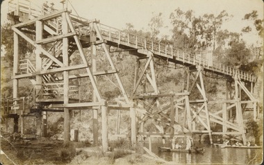
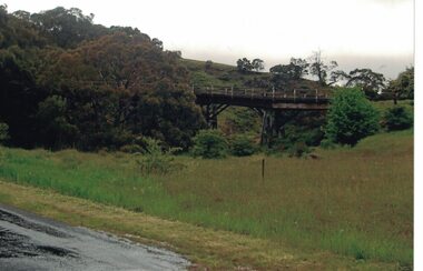
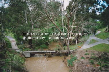
 Eltham District Historical Society Inc
Photograph, Fay Bridge, Diamond Creek in flood, Eltham, 13 November 2004
Significant flood events occurred Nov-Dec 2004 and Jan-Feb 2005.fay bridge collection, diamond creek (creek), 2004-11-13, brougham steet bridge, floods, floodwater, diamond street bridge, rocknall -
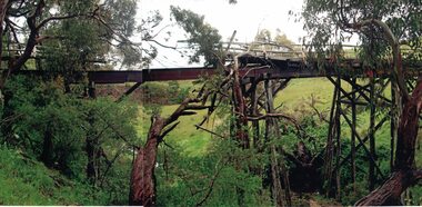
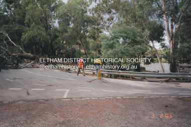
 Eltham District Historical Society Inc
Photograph, Fay Bridge, Flood damage to footbridges over the Diamond Creek, Eltham, 14 November 2004
Significant flood events occurred Nov-Dec 2004 and Jan-Feb 2005.fay bridge collection, 2004-11-14, bridge street bridge, diamond creek (creek), diamond street bridge, flood damage, floods, floodwater, footbridge, main road bridge, susan street oval, withers way -
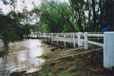
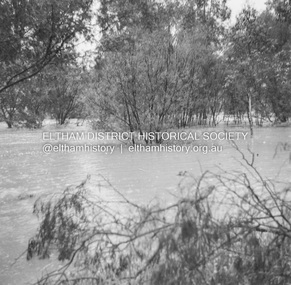
 Eltham District Historical Society Inc
Photograph, Fay Bridge, Diamond Creek in flood, Eltham, 3 February 2005
Significant flood events occurred Nov-Dec 2004 and Jan-Feb 2005.fay bridge collection, bridge street bridge, diamond creek (creek), floods, floodwater, footbridge, main road bridge, susan street oval, diamond street, eltham -
 Eltham District Historical Society Inc
Album - Photograph, J.A. McDonald, Eltham-Diamond Creek Road, 21 Oct. 1953
18 October 1956 Flooding on downstream line from Diamond Creek sideRecord of various Shire of Eltham infrastructure works undertaken during the period of 1952-1962 involving bridge and road reconstruction projects, sometimes with Eltham Shire Council Project Reference numbers quoted. It was during this period that a number of significant improvements were made to roads and new bridges constructed within the shire that remain in place as of present day (2022). In many situations, the photos provide a tangible visible record of infrastructure that existed throughout the early days of the Shire. The album was put together by or under the direction of the Shire Engineer, J.A. McDonald.infrastructure, road construction, shire of eltham, bridge construction, eltham north, floods, floodwater, glen park bridge, 1956-10-18, diamond creek (creek), eltham, railway parade, wattletree road, wattletree road bridge -
Malmsbury Historical Society
Photograph (Item), "Peter Bruni In Boat, Malmsbury Flood October 2000", Malmsbury oct 2000
People - "Bruni, Peter" Buildings - Cricket Ground Associated with - Herald Sun Flood -
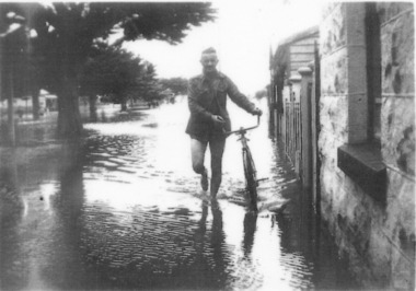 Port Fairy Historical Society Museum and Archives
Photograph
evidence of the 1946 floods in Bank Street outside the Keats house in Port Fairy Black and white photograph of Male walking a bicycle on footpathflood, river, bank street, 1946, keats -
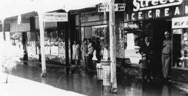 Charlton Golden Grains Museum Inc
Photograph, Cameron, Ian, c.1973
1973 Flood in High Street Charlton. Bill Landos outside his cafe. Black and white photograph with white boarder.1975 in blue biro written on bottomflood, cba bank, kenny's drapery, bill's cafe, charlton, business -
 Orbost & District Historical Society
black and white photograph, February 1971
This photograph is an aerial view of the township of Orbost taken by the Bairnsdale Advertiser newspaper. It was taken from the northern end of the town. The 1971 flood was the the worst flood on record. At Jarrahmond it was at least 11 metres and up to one and a half kilometres wide on the flats causing enormous damage to the flood plain. Records say that "The brown floodwater stain in Bass Strait could be seen from passing airliners." Considerable damage was done to railway infrastructure, roads and farms. More information from the APRIL, 2008 newsletter by John Phillips. (see orbosthistory.com.au)This is a pictorial record of a significant event in the history of Orbost,A black / white aerial photograph of a township with floodwaters in the background.on back - "Note main current through the lagoon 1971."orbost-floods-1971 bairnsdale-advertiser orbost-township