Showing 1317 items
matching local information
-
 Kiewa Valley Historical Society
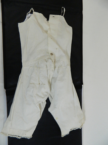
Undergarment Child
part of a three item pantaloon set of a child at different ages of development. As no manufacturing details are affixed to the garment and taking into account of the relative isolation when the garnet was made it is reasonably to make an assumption that it was made by a local seemstress or by the motherHistorical significance of the type of garment places it Circa 1930s to 1940s and is fairly rare to find the garment as part of three detailing the physical growth and development of a young child cross reference to KVHS 0248 and KVHS 0240Garment has sleeveless top with 8mm straps.The top is attached at the waist to the pantaloons. Pantaloons are crutchless extending down the inside of each leg to 17cm from the bottom.The back of the top is fastened by three plastic(not original) buttons. "Ric Rack" has been hand stitched onto the bottom of each leg. The rest of the garment has been machine stitchedNo manufacturer's details are on the garment vest, undergarment, underwear, lingerie child -
 Kiewa Valley Historical Society
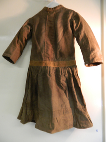
Dress
made locally circa 1910. Due to relative long distance to haberdashery stores majority of children's garments were hand made by a local talented seamstress or mother/relativeHistorical significant to the period circa 1900 to circa 1950 when fashion was dictated by long lasting durability, local manufacture, earthy colours and ease of mobility. Photos in the KVHS collection show girls from Tawonga Primary School in a dress that could be this dress which is dated 1910. Dress brown cotton with long sleeves. Dress top and sleeves lined. Back of dress is open with metal hooks for fastening. Hand stitched eyelets and decorative strip down centre front bodice and around hips. Gathered skirt is joined at hip. One pocket on left side 6cm from waist band.Decorative strip at bottom of dress with a pleated hand and machine stitched frill.no inscriptions or markings suggesting locally made.dress, clothing, girl's dress, home made -
 Kiewa Valley Historical Society
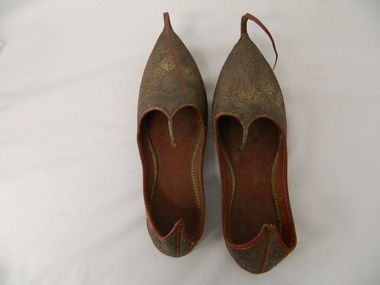
Shoes - Slippers
sourced from local resident of Kiewa Valley Mr David Barton. As theses shoes are from Turkey and from the period of the early 1900s they may have been bought back from that country as a souvenir after WWI. Members of the Barton family went to WWI . Manufacture of slippers circa 1920s and represents early Turkish style .These slippers are considered rare due to the intricate workmanship in leather. They have historical and good Provence significance due to being donated by a local man who possibly bought them back from WWI . Two brown slippers, left and right foot. Leather soles and gold patterned (circle and fish like) embroidered uppers. A long, 13cm leather strip upward curled, extension fastened at tip of sole. Back of heel extended to a pointPatterned front toe,side arch and heel. Markings may represent water ,four fish and fish traps -
 Kiewa Valley Historical Society
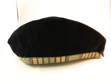
Cap - Head
Glengarry cap used in1906 by local scottish piper. Scottish pipe bands were extensively used as providing local communities with music from "the mother" country. The strong ties to the British Empire was still very alive in local communities.Historical significant pre Wold War 1 and the great ties the population had to everything English. This bond would decrease after World War 2. English isles music was very sought after up until the American presents was starting to increase.Black Glengarry cap, black velvet with tartan trim and cream coloured lining. Cap worn by members of Scottish pipe bands. Inverted pleat running along the top. Black two cap ribbons missingcap scottish bands headware clan influence -
 Kiewa Valley Historical Society
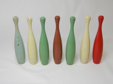
Skittles wooden, Circa 1980
Indoor children's toy. Historically these gained greater popularity when professional ten pin bowling had its major impact in Australian sport and recreation. This item was gifted by one who had played skittles as a child with her brother on carpeted passage in her home. Skittles was an indoor game.This item clearly represent a period in rural Australian development when entertainment and sporting facilities were broadcast but local access to professional facilities not readily availableThis is an incomplete set of toy wooden skittles. There are three green, two yellow, one red and one brown pin. The bottom and top have manufacturing markings from a wood turning machine. Full set is nine pinschildren, wooden, toy, skittles -
 Kiewa Valley Historical Society
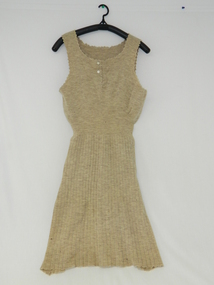
Dress Knitted
This dress was possibly manufactured by a local seamstress in the period circa early 1900.The quality of the dress suggests that the lady who wore it was from middle to upper range of the socio-economic structure within the Kiewa ValleyHistorically this item dating in the early 1900s was made by a very competent seamstress (lack of manufacturer's label). It demonstrates that the conditions of relative isolation within the Kiewa Valley was not extreme and that local manufacture of clothing items were available and at a very high level of quality. This item demonstrates that the hand made era was alive and an essential part of community/social adhesion within the valley.Beige knitted dress, sleeveless ladies pin weaved running from waist to bottom. Fine pin weave from bust to waist. Two mother of pearl buttons fastening opening front neck 11cm from neck to upper breastno manufacturer's label suggesting manufacturer was a very talented local seamstress costume, woollen, knitted, dress, female clothing -
 Kiewa Valley Historical Society
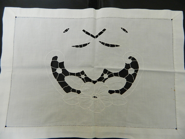
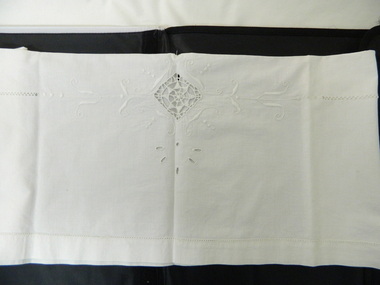
Pillow Sham, circa 1900
This Item is one of four bedroom items hand made in circa 1900 by Amalihe Pierin. Her Son brought the item when he emigrated to Australia and members of the family still reside in the Kiewa Valley. Historically this item represents the requirement by families to manufacture a whole range of bedroom coverings due to the lack of professionally manufactured goods. Isolation from big towns or cities required local seamstress activities and therefore closer social bonding was a necessity. Although this item was transported from Italy to Australia by the son of Amalihine Pierin the significance still remains the sameLinen (white) cut work and hand embroidered central floral scene with decorative cut work above, leaf shapes 2cm border with triangular hand stitching tatting embroidery, handcrafts, bedroom linen, trimmings, cut work -
 Kiewa Valley Historical Society
Pillow Sham
This Item is one of four bedroom items hand made in circa 1900 by Amalihe Pierin. Her Son brought the item when he emigrated to Australia and members of the family still reside in the Kiewa Valley. Historically this item represents the requirement by families to manufacture a whole range of bedroom coverings due to the lack of professionally manufactured goods. Isolation from big towns or cities required local seamstress activities and therefore closer social bonding was a necessity. Although this item was transported from Italy to Australia by the son of Amalihine Pierin the significance still remains the sameLinen (white) cut work and embroidered central floral scene with decorative cut work above leaf shapes 2cm border with triangular hand stitching attine.embroidery, handcrafts, bedroom linen, trimmings, cut work -
 Kiewa Valley Historical Society
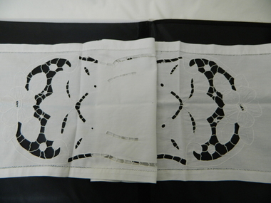
Bed Runner, circa 1900
This Item is one of four bedroom items hand made in circa 1900 by Amalihe Pierin. Her Son brought the item when he emigrated to Australia and members of the family still reside in the Kiewa Valley. Historically this item represents the requirement by families to manufacture a whole range of bedroom coverings due to the lack of professionally manufactured goods. Isolation from big towns or cities required local seamstress activities and therefore closer social bonding was a necessity. Although this item was transported from Italy to Australia by the son of Amalihine Pierin the significance still remains the samelinen white cut work and embroidered central oval shape with matching floral design at either end with leaf leaf shapes above 2cm border with triangular stitching tattine embroidery, handcrafts, bedroom linen, trimmings, cut work -
 Kiewa Valley Historical Society
Table Runner Dressing
This Item is one of four bedroom items hand made in circa 1900 by Amalihe Pierin. Her Son brought the item when he emigrated to Australia and members of the family still reside in the Kiewa Valley. Historically this item represents the requirement by families to manufacture a whole range of bedroom coverings due to the lack of professionally manufactured goods. Isolation from big towns or cities required local seamstress activities and therefore closer social bonding was a necessity. Although this item was transported from Italy to Australia by the son of Amalihine Pierin the significance still remains the sameLinen (white) cut work and embroidered central design tatting diamond shape with embroidered scrolls either side cut work leaves top and bottom L shaped tatting inner border with triangular tatting 2cm outer bordered hole patternembroidery, handcrafts, bedroom linen, trimmings, cut work -
 Kiewa Valley Historical Society
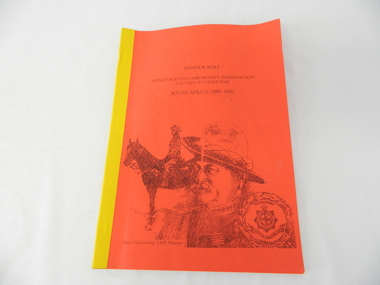
Book - Non Fiction History, Honour Roll - South Africa 1899 - 1902 Albury-Wodonga and District Residents Who Served In The Boer War, reprinted 03/2008
Historical information of soldiers from the Albury-Wodonga district who fought in the Boer War in South Africa 1899 - 1902. In 1996 the then curator for the 8/13 VMR Museum, the Hon Colonel John Neale, commissioned the author to research a group of returned servicemen and women from the Boer War and had lived within 100 km radius of the Albury/Wodonga townships.The Boer War was the second war in South Africa and was the result of heavy taxes and non voting rights of the local white Boer population. Colonial forces including the Australian Light Horse contingent where called upon by England to overthrow the rebellion. This War was the first engagement of Australian troops fighting on foreign soil.This Honour Roll details the pay rates, the battle highlights, weapons used and maps covering the first Australian contingent of soldiers who fought in the Transvaal (Boer War).. Listed are the names of those soldiers who lived within 100klms of Albury and Wodonga.The soldiers are listed by Location, Rank, Initial,Name and Unit. The significance of both the War and those who served in it is two fold. Firstly it demonstrates that the tie between the Colonial outreaches of England's Empire to "the Motherland" were extremely strong at this point in time. This union remained strong up until the middle of World War II when England could not help Australia to defend itself against possible invasion by Japan. The alliance between Australia and the United States of America replaced the British/Australian pact. Secondly the attitude of, and the high degree of horsemanship of those from the Albury and Wodonga area. The degree of adaptability, by these servicemen, to suit the environment in which they fought provided the first real insight into the Australian psyche "of those living and surviving on the harsh Australian outback"This book has a bright red soft cover and is bound with bright yellow tape. There is a drawing of two Australian soldiers on the front, one on horsebackAuthor's complimentary inscription "To Mount Beauty Museum with compliments" signed Ian R Docking history, boer war, ex-servicemen and women, albury and wodonga -
 Kiewa Valley Historical Society
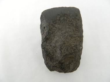
Axe Head, Before European settlement
This item was used well before European settlement and clearly demonstrates the development of the local Aboriginal tribes, Dhudhuroa and Yaitmathang in the use of a cutting /chopping implement, made from Mount William sourced material i.e. greenstone. This item was probably traded at the Bogong Mountain tribal yearly summer ceremoniesThe significance of this item places it at the fore front of human development in this region. The period when this tool was manufactured represents the time when the natural landscape had not been altered and the natural vegetation, fauna and flora, had not been subjected to imported species.This also proves that local tribes did live in this area and or the Bogong High Plains.Small ground edge stone axe head. Leading cutting edge very smooth and chiseled to a fine edge. Weight is, for its size fairly heavy. It is made from Greenstoneaboriginal tool stone ground-edge axe indigenous tool -
 Kiewa Valley Historical Society
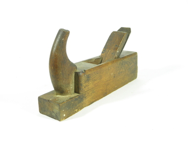
Plane Wood, 1890 -1900
J.E. Bleckmann were German Blade makers, registry shows Bleckmann (1899, No. 37190):J.E.Bleckmann, Solingen, registry class 9b). As well as blades for wood working tools they were also sword makers (used in American Civil War), Bayonet makers 1871-1918 and also pocket cutlery (pocket knives) as per advertisement 1907.This wood plane holds historical importance as carpentry tools such as this would have been used in the construction of local homes, outbuildings, furniture. It represents an era before power tools. Investigation is ongoing as to ownership and specific use in the area. Hand made wooden hand plane with metal blade. Carpentry tool from 19th century1/38 / 34 mm stamped into wood on front edge of plane. Metal Blade inscribed "J.E. BLECKMANN/ WARRANTED / CAST STEEL / SOLINGEN/GERMANY"tool, blade makers, hand plane, woodworking. -
 Kiewa Valley Historical Society
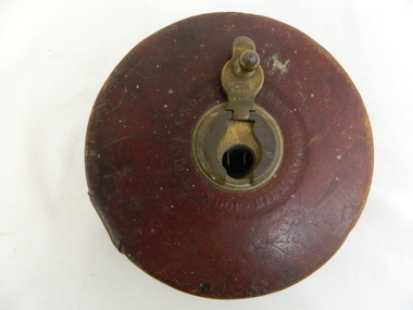
Tape Measure, mid 1900s
This item predates the change of Imperial measure (England -1824) to decimal measure (Europe) in Australia (1970 to 1988). This item was manufactured in England as, was the majority of measuring tool and equipment. It was not until the late 1950s that other countries e.g. United States and Europe provided the same type of manufactured tools for the Australian market. World War II, when Australia had to defend its own boarders that the political push for self sufficiency of manufactured goods started local production. Workers in the Kiewa Valley had always relied on the high quality of tools and manufactured goods coming from England. From the middle to late 1950s migration by skilled workers from a war torn Europe provided the source of manpower for the expansion of the manufacturing industries in Australia.The requirement of an accurate measuring tool has always been critical. This item was used at the time when Australia was using the British Imperial measurements. Accurate measurements by carpenters and other trades people for both town and rural needs was just as critical as for the larger cities. The transition period from Imperial to metric was a period of over four years but it still presented those who had used the Imperial measurements for a longer period in their trades with a dual system of measurement for a longer time(usually up to their retirement) Other nations still using Imperial measurements kept the transition from Imperial to metric alive (the UK and USA still uses Imperial measurements in 2012)Retractable metallic wired tape measure within a leather casing. Length of tape is 66 feet. Brass fittings on casing(winder and back plate)Tape on one side marked in inches and feet and on the other in links. Winder lever marked "66ft No 401" on front and arrow with"wind this way". Leather cover marked "John R A Bone & Sons Birmingham England" on reverse side "Metallic wired tape R A Bone & Sons"wired tape measure, tool, mobile tool, construction tool -
 Kiewa Valley Historical Society
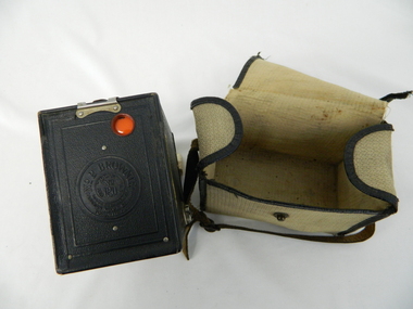
Bag Camera, circa 1920s
This item was manufactured in a period where the cheapest containers for portable equipment was canvas. The market place for cheap cameras was still restricted to European, England and its colonies. It was well before the post World War II explosion of the Asian manufacturing juggernaut.This item shows one of the most popular avenues of not only bringing new "modern" age equipment into the Kiewa Valley but also providing the local market with actual overseas inexpensive merchandise. It was a time when the new European fashion and "new age" equipment took years to permeate into regional Australia. The world, through Australia eyes, was still a very large planet and supply of "modern" lifestyle equipment emphasised the geographic isolation of Australia. Post World War II emigrants and an increasing flow of tourists to Australia provided the contact needed by rural settlements to open up not only their social contacts but lifestyle activities.Canvas, yellow, cream in color and with a weave pattern on the external side. It has stitched brown laminated fabric boarders containing all ends and corners. A flap opening top fastened on one side by a large press stud (15mm). A brown coloured leather carry strap (adjustable and 10mm wide) fasted at either of the longitudinal ends of the bag.camera, case photography, hobby, personal equipment -
 Kiewa Valley Historical Society
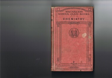
Book - Reference Chemistry, Elements of Chemistry, first printed 1887 this item 1921
This item is a good example of a pre 1960's school science reference books. It contains sketches of experimental apparatus and not colored photographs of later text books. Although the sketches are very instructional they do not show the various colours obtained when mixing some compounds. The history of reprints demonstrates the quality of the information and the ease of study for students using this book. The era of this publication was a time when sources for knowledge in schools was restricted to mainly school books and teacher demonstrations. The student in the 2 Millennium has a far greater reference source available e.g. the internet. This book is significant to the Kiewa Valley as the Davies family (Tas Davies, penned on the first page), belong to the early settlers of the valley. The book acknowledges that although the region was relatively isolated up to the mid 1900s, the good teaching methods of local schools did not suffer in this rural area. This region was not in the backwaters of scholarly development and modern progressive thought. As with "school of the air" distances in rural areas, between centres of learning and recipients, became irrelevant provided that the social stimulant to learn exists. The "local school" mind set within rural areas was, even before the improvement of the communication "explosion" of the early 1900s followed by the internet facilities of the late 1900s, the greatest drive in cutting the anomalies between city and rural learning facilities. Government decentralising higher education facilities into regional centres (Wodonga - Albury) provided greater access for the learned mind.This item (book) has a faded red colour, hard cover with black print and rectangular design. Within this design is an encircled double "M" and "&" (in the left inverted V of the M) and a "Co" (in the right inverted V of the M). On the front cover "MACMILLAN'S SCHOOL CLASS BOOKS CHEMISTRY" and on the spine "ELEMENTS OF CHEMISTRY" underneath "REMSEN" and at the bottom"MACMILLAN & Co"school, chemistry, text books, science experiments -
 Kiewa Valley Historical Society
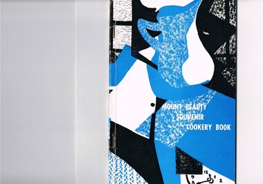
Book - Reference Cooking, Mount Beauty Souvenir Cookery Book x2, Circa 1962
This cookery book was printed in the early 1960s for the purpose of obtaining the necessary funds for the construction of the Mount Beauty swimming pool. The advertisements within this book covers local traders of this time frame, for example, the Bogong Hotel which is no longer operational. the culinary measurements are in Imperial measures(pounds and ounces). The book has sections for continental dishes and sweets (Australian flavour), special dishes for Lent, cakes (farmhouse fruit cake), jams, marmalades (home made), marrow and apple chutney. Some of these recipes are early 20th Century related and in the 2000s are not sought after. The food "take away" lifestyle has been responsible for the demise of a lot of the recipes in this book. The swing away from home grown produce has been not only a lifestyle change but also the faster pace of living in rural areas. The specialisation and redefined development of the local produce store (previously provided everything the rural shopper needed) was a forced move due to larger and cheaper city born fresh food supermarkets. Although there are still some local produce store within the region these will in time vanish. This cookery book was produced just after Mount Beauty was released from an SEC "closed" community in 1961(see KVHS 0134) and the town then had to fend for itself. This book was compiled and produced because the town needed a swimming pool (which possible would have been provided had the SEC still been responsible). The book demonstrates the strong rural psyche of rallying together for the good of all and united for something which would be of benefit to all. The period 1961 to the 1970s was one of great change for Mount Beauty. The SEC protective cage was a blessing for some but a goal for others. The independence that was gained after the SEC left provided for a drastic "make over" in regards to the facilities provided for the "locals" and that for the tourists. An increase in tourist related industries such as snow skiing in winter, hang gliding and gliding, mountain bike rallies, bush walking and horse riding, all of which have supply outlets in the town, has provided a more cosmopolitan atmosphere. These activities and the greater interaction with populations outside of the region has reduced the "hermit" type feel of the town psyche.This recipe book consists of eighty nine pages in black and white print. It contains black and white sketches, recipes of local domestic cooks and advertisements covering local traders. The cover is approximately 280 g/m2 in weight and the pages are at 90 g/m2 in weight. The cover has a design in the style of Abstract Expressionism (period 1950-1960s) of identifiable (clock,jug,fruit,window) and abstract objects in tints of blue and shades of black. This was designed by Cheryl Ryder of the Mount Beauty High School, under supervision of Mr I Baker (Art Teacher)On the foreword(page two and page three) "Mt. Beauty Souvenir Cookery Book First Edition" . This foreword was presented by Rosa Kinnear, President, Ladies' Auxiliary 2nd copy - no inscriptionrecipe, cooking, food, domestic, kitchen, local history, comfort food, pioneer cleaning methods -
 Kiewa Valley Historical Society
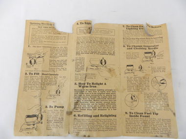
Document Instruction and Parts Sheet, Instructions for Operating the Coleman Self Heating Iron Model No. 4 Instant Lighting, circa 1950
This operating and parts information sheet was supplied to consumers to help users of this kerosene iron, not only understand the operation of this self lighting iron, but also to be able to order any replacement parts that may be required for this high level usage appliance. At this period in time(1950's), this item was at the leading edge of ironing technology. During the earlier 1900's and before "the throw away" culture evolved(circa 1950's), reliability and long term application of domestic appliances was a necessity above all costs, especially in isolated rural areas. The construction of these appliances was geared to a longer service life and not to a cheaper two to three year life warranty. With levels of world wide technology at an ever increasing pace, long term reliability of any appliance was no longer sought after. Appliance upgrades and new improved model accessibility especially in rural areas has changed rural consumer's buying patterns. Although the concept of instructional and parts/warranty information booklets has not become obsolete, the ability to access information via electronic means has vastly improved the ability to obtain qualified technical help through local avenues. This access was not available in the time period(circa 1950), when the appliance covered by this document was issued. The rate of development within the home appliance field has mushroomed during the time period post 1950. The costs and the increased levels of product choices and consumer awareness has provided rural areas (once isolated e.g. Kiewa Valley) with a greater ability to satisfy their needs because of a greater diverse range of domestic appliances offered.This discoloured, sepia paper has black print and is folded into three equal pages. The information contained covers operational and part numbers for the kerosene fired hand held iron. there are kerosene stains on the last page and these have soaked through onto the second page. The form no.-3-3C- McACO.-4363Printed in U.S.A.instructions, household appliances, ironing, domestic ironing -
 Eltham District Historical Society Inc
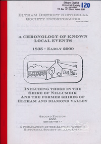
Book, Harry Gilham, A chronology of known local events 1835 - early 2000 including those in the Shire of Nillumbik and the former Shires of Eltham and Diamond Valley, 2000
2nd edition. "The design of this document is to provide information to access known publications and resource collections that are publicly available for study... this collection of 974 historical events is not complete". The publication is arranged by year order with a brief statement of historical event with source abbreviation. Source list provided. Includes index. Produced by the Eltham District Historical Society Inc.This edition, one of several, is a significant reference document for the history of the Shire of Nillumbik and former Shires of Eltham and Diamond Valley bringing together a timeline of key events in the history of this local community. Softcover; 1 v. (unpaged) ; 30 cm.ISBN 0957719817shire of eltham, shire of diamond valley, chronology, eltham district historical society -
 Eltham District Historical Society Inc
Folder, Lois and Geoffrey Loftus-Hills
Lois Loftus-Hills (1927-2006) and her husband Geoffrey were founding members of the Australian Democrats. Lois was the editor of the national Journal. Lois was trained in the field of dietetics and when working at the CSIRO met Geoffrey. They lived at Lower Plenty and were instrumental in establishing a local Neighbourhood House. Lois was a member of EDHS. (NL-170)Folder of information on Geoffrey and Lois Loftus-Hills, Lower Plentylois loftus hills, geoffrey loftus hills -
 Eltham District Historical Society Inc
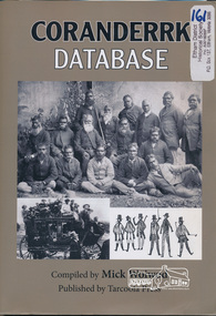
Book, Tarcoola Press, Coranderrk Database compiled by Mick Woiwod, 2012
Database of information on Coranderrk 1835 to 1995.Winner of the Local History Project Award (for activities that enhance access to records of significance to local communities) as part of the Victorian Community History Awards 2012 242 pages : illustrations ; 30 cm + 1 CD-ROM (4 3/4 in.) PDF, Word files.ISBN 9780987157416green, john., bon, anne fraser, 1838-1936., coranderrk aboriginal station. -
 Eltham District Historical Society Inc
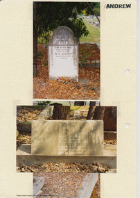
Folder, Andrew
James Andrew Kangaroo Ground, 1870 "James Andrew, Whittlesea, born in East Palford, Devonshire, England, in 1827, arrived in Adelaide in February 1850 per ship Lady McCaughton and almost immediately sailed in a coasting vessel to Melbourne, where the first work he undertook was clearing earth from a stone quarry in Collingwood. He next carried stones for masons engaged in building the Bishop’s Palace, and then was employed in Cambellfield mowing hay. He was at Saltwater River on Black Thursday, and afterwards took a little farm at Darebin Creek, remaining there for four years. He went up to Kangaroo Ground in 1859 and lived there until he bought his present property at Whittlesea, a farm of between 300 and 400 acres. He has been twice married, and had a family of six children." "Andrew, W. B. Eltham, is a native of England, born in 1822. Coming out to Australia in 1842, he lived in Brighton, Victoria for fifteen years, when he re-visited England for a year. Returning to Victoria fourteen or fifteen years ago, he commenced storekeeping at Eltham, where he has carried on that business ever since. Mr Andrew has always taken a lively interest in the public affairs of town and district” from "Victoria and its Metropolis: Past and Present" written in 1888 by Alexander Sutherland. Chapter 19, "The Upper Yarra District" pages [402] - 415. Includes descriptions of some townships and short biographies of local residents. Page 405 Folder of information on James Andrew, Trustee Kangaroo Ground Cemetery, Kangaroo Ground 1870 William Bravery Andrew, Eltham, 1870s-1880s Ernest James Andrew, Eltham, Eltham Shire Councillor, 1920s-1950 and Ellen Matilda Brown Andrewjames andrew, pioneer, kangaroo ground, ernest james andrew, william bravery andrew, ellen andrew, eltham cemetery, biography, ellen harper andrew (nee clarke), ellen matilda andrew (nee brown), eltham war memorial gate, eltham war memorial trust -
 Eltham District Historical Society Inc
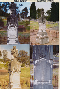
Folder, Armstrong
Alfred Armstrong Armstrong, Alfred, Eltham is a native of Somerset, England, born in 1825, and was employed under Mr. Mark Isambard Kingdom Brunel as a civil engineer prior to his coming out to Melbourne in 1852. He first visited Beechworth, but returning to Melbourne took contacts at Essendon and Gisbourne for forming and metalling the road. He afterwards purchased property at Eltham, where is at present mining, surveyor, inspector of mines, and mining registrar for the St Andrew’s division of the Castlemaine mining district. Mrs Armstrong, to whom he was married in 1854, at St Paul’s Church, Melbourne, died on 27th March, 1887. from "Victoria and its Metropolis: Past and Present" written in 1888 by Alexander Sutherland. Chapter 19, "The Upper Yarra District" pages [402] - 415. Includes descriptions of some townships and short biographies of local residents. Page 405 Folder of information on Alfred Armstrong, Eltham and Kangaroo Groundalfred armstrong, ada gertrude armstrong, arthur reynolds stockwood armstrong, arthur vivian harrison, eltham cemetery, gravestones, laura augusta harrison (nee armstrong), margaret armstrong, mary armstrong, thomas armstrong -
Eltham District Historical Society Inc
Folder, Thomas Armstrong
Armstrong, Thomas, J.P. Yarra Flats, was born in Roxburghshire, Scotland, in 1818, and in 1838, being then twenty years of age, emigrated to Australia, and engaged in taking contracts. In 1841, in conjunction with Mr. Wm. Bell he took out a squatting license and settled in what is now known as the township of Eltham. Mr Armstrong purchased land on Kangaroo Ground, where he lived, until 1854, and then bought from Mr. John Dickson, a station on Yarra Flats, containing about 100,000, which at the expiration of two years was sold by public auction. Messrs Armstrong and Bell then bought 14,000 acres where Mr Armstrong, now resides. He has been a member of the local council for twenty-eight years, and holds Her Majesty’s commission of the peace. His wife, Miss Diana Bell (daughter of his partner, Mr. Wm. Bell), whom he married in 1841, died fifteen years ago. from "Victoria and its Metropolis: Past and Present" written in 1888 by Alexander Sutherland. Chapter 19, "The Upper Yarra District" pages [402] - 415. Includes descriptions of some townships and short biographies of local residents. Page 405 Folder of information on Thomas Armstrong, JP, Kangaroo Groundthomas armstrong -
Eltham District Historical Society Inc
Folder, Simon Armstrong, 1868
Simon Armstrong Armstrong, Simon, Kangaroo Ground, is a native of Scotland, born in 1822. In October 1839 he came to Melbourne where he remained for one year, after which he went to Essendon, and stayed there until 1867, when he went to Kangaroo Ground, and established himself as a farmer on partially improved land purchased from Mr Thomas Armstrong; and he also possesses 160 acres at Yarra Flats, which he uses for grazing purposes. Mr Armstrong was married in 1854, and has a family of two sons and five daughters. from "Victoria and its Metropolis: Past and Present" written in 1888 by Alexander Sutherland. Chapter 19, "The Upper Yarra District" pages [402] - 415. Includes descriptions of some townships and short biographies of local residents. Page 405 Folder of information on Simon Armstrong, Kangaroo Ground, 1868simon armstrong -
Eltham District Historical Society Inc
Folder, Mary and James Bradford, 1880s
Folder of information on Mary and James Bradford, Hazel Glen, 1880s James Bradford. Hazel Glen. Was born in 1839, in Devonshire, England, whence he went to Canada, British America in 1875, remaining there until 1880, when he came to Australia, and at once commenced farming at Hazel Glen on his own freehold. He was married in 1867. from "Victoria and its Metropolis: Past and Present" written in 1888 by Alexander Sutherland. Chapter 19, "The Upper Yarra District" pages [402] - 415. Includes descriptions of some townships and short biographies of local residents. Page 405 mary bradford, james bradford, hazel glen -
Eltham District Historical Society Inc
Folder, Ewen Cameron
Cameron, Ewen Hugh, M.L.A.., J.P. Kangaroo Ground, is a native of Inverness-shire, Scotland, and came out to Victoria in the ship Hurricane, 13th September, 1853. After he had been engaged for two years int eh building trade in Melbourne in company with is two brothers, since dead, he carried on storekeeping for several years at the Caledonia gold diggings. In 1860 he purchased 80 acres of land at Kangaroo Ground, where he now resides, and later 160 aces of lands at Yarra Flats; he has also 600 acres rented, and is occupied in grazing and agricultural pursuits generally. Mr Cameron holds the prize given by the agricultural society for the best-kept farm in the district. In 1863 he was elected a member of the shire council, and has held the position to represent the Castlemaine mining board, which office he still holds, and in 1874, he was elected to a seat in the Legislative Assembly for the County of Evelyn, which seat he still retains, having the contested the constituency five times, and been elected once without opposition. from "Victoria and its Metropolis: Past and Present" written in 1888 by Alexander Sutherland. Chapter 19, "The Upper Yarra District" pages [402] - 415. Includes descriptions of some townships and short biographies of local residents. Page 405 Folder of information on Ewen Hugh Cameron, MP, Kangaroo Groundewen cameron, pigeon bank -
Eltham District Historical Society Inc
Folder, J.D. and E. Cameron, 1850s
Cameron, Ewen Hugh, M.L.A.., J.P. Kangaroo Ground, is a native of Inverness-shire, Scotland, and came out to Victoria in the ship Hurricane, 13th September, 1853. After he had been engaged for two years int eh building trade in Melbourne in company with is two brothers, since dead, he carried on storekeeping for several years at the Caledonia gold diggings. In 1860 he purchased 80 acres of land at Kangaroo Ground, where he now resides, and later 160 aces of lands at Yarra Flats; he has also 600 acres rented, and is occupied in grazing and agricultural pursuits generally. Mr Cameron holds the prize given by the agricultural society for the best-kept farm in the district. In 1863 he was elected a member of the shire council, and has held the position to represent the Castlemaine mining board, which office he still holds, and in 1874, he was elected to a seat in the Legislative Assembly for the County of Evelyn, which seat he still retains, having the contested the constituency five times, and been elected once without opposition from "Victoria and its Metropolis: Past and Present" written in 1888 by Alexander Sutherland. Chapter 19, "The Upper Yarra District" pages [402] - 415. Includes descriptions of some townships and short biographies of local residents. Page 405 Folder of information on J D and E Cameron, land purchasers, Eltham, c.1850sj.d cameron -
 Warrnambool and District Historical Society Inc.
Folder, Warrnambool Theatre Chorale documents, 1990's
This collection of papers relating to the Warrnambool Theatre Group chorale contains AGM minutes, performance programs, publicity and Warrnambool Standard information and membership lists. Some of the programs relate to performances which were done by the Warrnambool Theatre company of which this group was an off shoot. There are some Christmas programs and shows involved with the Warrnambool Symphony Orchestra. This folder relates to the years 1991-1995 and is one of 3 folders which relates to the Warrnambool Theatre Group Chorale. Chorale shows a number of connections between local groups some musical others are community groups. The programs show the variety of songs which were popular at the timeGrey folder with items relating to the Warrnambool theatre chorale from 1991-1995. The entries include concert programs, advertising material and financial statements.warrnambool theatre group chorale, warrnambool, warrnambool theatre company, -
 Warrnambool and District Historical Society Inc.
Folder, Warrnambool Theatre Chorale documents, Late 20th century
This collection of papers relating to the Warrnambool Theatre Group chorale contains AGM minutes,office bearers, publicity and Warrnambool Standard information as well as membership lists. Some of the programs relate to performances which were done by the Warrnambool Theatre company of which this group was an off shoot. The dates range from the 1989 to 2012.This collection of papers connected to the Warrnambool Theatre Group Chorale shows a number of connections between local groups some musical others are community groups. Grey folder with items relating to the Warrnambool theatre chorale from 1989 to 2012. The entries include concert programs, advertising material and financial statements.