Showing 11121 items
matching planning
-
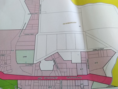 Peterborough History Group
Map - Peterborough Planning Map
Planning information as at 2012Showing the changing face of PeterboroughA3 size printed copies (2) of planning, environmental and other overlays for the town of Peterborough in 2012peterborough, town planning, maps, moyne shire zoning map -
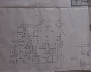
 Stawell Historical Society Inc
Map - Drawings, Wendy Jacobs, Western Highway Community Precinct Development Structural Drawings, 2014
501 Slab and Footing Plan. 502 Slab and Footing Details. 505 Roof Framing Plan 506 Steel Framing Elevations - Sheet 1. 507 Steel Framing Elevations and Sections - Sheet 2 508 Steel Framing Details - Sheet 1 509 Steel Framing Details - Sheet 2 SN1 General Notes, Site map & Drawing Index Used in building Historical Society Building Eight (8) A1 Printed plans Structural DrwaingsWendy Jacobs Architect & Heritage consultant may 2014 -
 Kew Historical Society Inc
Plan - Subdivision Plan, Houghton Street & Buchanan Avenue, Balwyn North, ca. 1906
The Kew Historical Society collection includes almost 100 subdivision plans pertaining to suburbs of the City of Melbourne. Most of these are of Kew, Kew East or Studley Park, although a smaller number are plans of Camberwell, Deepdene, Balwyn and Hawthorn. It is believed that the majority of the plans were gifted to the Society by persons connected with the real estate firm - J. R. Mathers and McMillan, 136 Cotham Road, Kew. The Plans in the collection are rarely in pristine form, being working plans on which the agent would write notes and record lots sold and the prices of these. The subdivision plans are historically significant examples of the growth of urban Melbourne from the beginning of the 20th Century up until the 1980s. A number of the plans are double-sided and often include a photograph on the reverse. A number of the latter are by noted photographers such as J.E. Barnes.A hand-drawn subdivision plan listing six blocks bounded by Houghton Street, Doncaster Road, Buchanan Avenue and Maud Street, North Balwyn. Written on the plan of subdivision are the lot numbers, the dimensions of the blocks and the price at which two lots were for sale or had been sold for.subdivision plans - balwyn -
Broadmeadows Historical Society & Museum
Book - Publication, Broadmeadows District Centre Structure Plan, 1988
... Planning ...Written For City of Broadmeadows and Ministry for Planning and EnvironmentHardcover, 104pp. Report in house-bound cover by Merri-bek City Libraries (Formally Moreland City Libraries)non-fictionWritten For City of Broadmeadows and Ministry for Planning and Environmentstructure, planning, broadmeadows, city of broadmeadows, town centre -
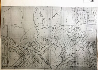
 Kew Historical Society Inc
Plan, Melbourne & Metropolitan Board of Works : Borough of Kew : Detail Plan No.1578, 1904
The Melbourne and Metropolitan Board of Works (MMBW) plans were produced from the 1890s to the 1950s. They were crucial to the design and development of Melbourne's sewerage and drainage system. The plans, at a scale of 40 feet to 1 inch (1:480), provide a detailed historical record of Melbourne streetscapes and environmental features. Each plan covers one or two street blocks (roughly six streets), showing details of buildings, including garden layouts and ownership boundaries, and features such as laneways, drains, bridges, parks, municipal boundaries and other prominent landmarks as they existed at the time each plan was produced. (Source: State Library of Victoria). This plan forms part of a large group of MMBW plans and maps that was donated to the Society by the Mr Poulter, City Engineer of the City of Kew in 1989. Within this collection, thirty-five hand-coloured plans, backed with linen, are of statewide significance as they include annotations that provide details of construction materials used in buildings in the first decade of the 20th century as well as additional information about land ownership and usage. The copies in the Public Record Office Victoria and the State Library of Victoria are monochrome versions which do not denote building materials so that the maps in this collection are invaluable and unique tools for researchers and heritage consultants. A number of the plans are not held in the collection of the State Library of Victoria so they have the additional attribute of rarity.Original survey plan, issued by the MMBW to a contractor with responsibility for constructing sewers in the area identified on the plan within the Borough of Kew. The plan was at some stage hand-coloured, possibly by the contractor, but more likely by officers working in the Engineering Department of the Borough and later Town, then City of Kew. The hand-coloured sections of buildings on the plan were used to denote masonry or brick constructions (pink), weatherboard constructions (yellow), and public buildings (grey). MMBW Plan No.1578 is significant in that it defines the extent of two private schools: Xavier College and Kew High School (now part of Trinity Grammar) by 1904. In relation to the latter, the plan clarifies which buildings the High School operated from behind the mansion ‘Molina’. Established in 1902, Trinity Grammar was to later lease and subsequently buy Molina (now ‘Merritt House’) and ‘Elsinore’ (now ‘Roberts House’). Xavier College had been established in 1872. This 1904 plan delineates the West Wing and the Great Hall (built in 1890).melbourne and metropolitan board of works, detail plans, maps - borough of kew, mmbw 1578, cartography -
 Kew Historical Society Inc
Plan, Melbourne & Metropolitan Board of Works : Borough of Kew : Detail Plan No.1590, 1905
The Melbourne and Metropolitan Board of Works (MMBW) plans were produced from the 1890s to the 1950s. They were crucial to the design and development of Melbourne's sewerage and drainage system. The plans, at a scale of 40 feet to 1 inch (1:480), provide a detailed historical record of Melbourne streetscapes and environmental features. Each plan covers one or two street blocks (roughly six streets), showing details of buildings, including garden layouts and ownership boundaries, and features such as laneways, drains, bridges, parks, municipal boundaries and other prominent landmarks as they existed at the time each plan was produced. (Source: State Library of Victoria)This plan forms part of a large group of MMBW plans and maps that was donated to the Society by the Mr Poulter, City Engineer of the City of Kew in 1989. Within this collection, thirty-five hand-coloured plans, backed with linen, are of statewide significance as they include annotations that provide details of construction materials used in buildings in the first decade of the 20th century as well as additional information about land ownership and usage. The copies in the Public Record Office Victoria and the State Library of Victoria are monochrome versions which do not denote building materials so that the maps in this collection are invaluable and unique tools for researchers and heritage consultants. A number of the plans are not held in the collection of the State Library of Victoria so they have the additional attribute of rarity.Original survey plan, issued by the MMBW to a contractor with responsibility for constructing sewers in the area identified on the plan within the Borough of Kew. The plan was at some stage hand-coloured, possibly by the contractor, but more likely by officers working in the Engineering Department of the Borough and later Town, then City of Kew. The hand-coloured sections of buildings on the plan were used to denote masonry or brick constructions (pink), weatherboard constructions (yellow), and public buildings (grey). Surveyed by the Board of Works in 1903 and published in 1904, Plan No.1590 shows development north of Cotham Road. While this plan includes built structures in Mary Street, Cotham Road, High Street, Park Hill Road, Kent Street, Ridgeway Avenue, and Ermington Lane (now Ermington Place), only part of this section was notated and coloured in this contractor’s copy. Numerous houses, large and small are named on the plan: ‘Cholula’, ‘Belper’, ‘The Uplands’, ‘Spring Grove’ facing Cotham Road; ‘Marion’ facing Kent Street; and ‘Kia Ora’ facing Ridgeway Avenue.melbourne and metropolitan board of works, detail plans, mmbw 1590, survey plans - borough of kew, cartography -
Clunes Museum
Plan - Building Plans, Proposed Layout Plan Clunes Neighborhood House, 12 June 2009
Architectural plan of proposed Clunes Neighborhood House Free Lending Library Development.A1 size architectural plan of proposed Clunes Neighborhood House Free Lending Library Development. Includes floor plan, front and side elevations. Dated 12 June 2009 by Kevyn Joy Architects.clunes neighbourhood house, kevyn joy architects, building plans -
 Kew Historical Society Inc
Plan, Melbourne & Metropolitan Board of Works : Borough of Kew : Detail Plan No.1302, 1910
The Melbourne and Metropolitan Board of Works (MMBW) plans were produced from the 1890s to the 1950s. They were crucial to the design and development of Melbourne's sewerage and drainage system. The plans, at a scale of 40 feet to 1 inch (1:480), provide a detailed historical record of Melbourne streetscapes and environmental features. Each plan covers one or two street blocks (roughly six streets), showing details of buildings, including garden layouts and ownership boundaries, and features such as laneways, drains, bridges, parks, municipal boundaries and other prominent landmarks as they existed at the time each plan was produced. (Source: State Library of Victoria)This plan forms part of a large group of MMBW plans and maps that was donated to the Society by the Mr Poulter, City Engineer of the City of Kew in 1989. Within this collection, thirty-five hand-coloured plans, backed with linen, are of statewide significance as they include annotations that provide details of construction materials used in buildings in the first decade of the 20th century as well as additional information about land ownership and usage. The copies in the Public Record Office Victoria and the State Library of Victoria are monochrome versions which do not denote building materials so that the maps in this collection are invaluable and unique tools for researchers and heritage consultants. A number of the plans are not held in the collection of the State Library of Victoria so they have the additional attribute of rarity.Original survey plan, issued by the MMBW to a contractor with responsibility for constructing sewers in the area identified on the plan within the Borough of Kew. The plan was at some stage hand-coloured, possibly by the contractor, but more likely by officers working in the Engineering Department of the Borough and later Town, then City of Kew. The hand-coloured sections of buildings on the plan were used to denote masonry or brick constructions (pink), weatherboard constructions (yellow), and public buildings (grey). The absence of buildings and or property in Kew facing the Yarra is the most notable feature of this plan. Walmer Street and its bridge stretched, then and now, from Studley Park Road to Victoria Street, Richmond. On the Richmond side of the Yarra, there was evidence in 1904 of industry (‘Wool shed’; Soap Works’) and entertainment (‘Skittle Alley’). In reality, another Plan (No.1303) shows Chinese Gardens bordering the Yarra on the Kew side and buildings in Young Street.melbourne and metropolitan board of works, detail plans, mmbw 1302, cartography -
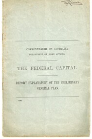 Melbourne Tram Museum
Document - Report, Walter Burley Griffin, Federal Capital Director of Design and Construction, "The Federal Capital - Report Explanatory on the Preliminary General Plan", Oct. 2013
... Planning ...Report - 16 pages + two plans within a grey cover stapled - titled "Commonwealth of Australia Department of Home Affairs - The Federal Capital - Report Explanatory on the Preliminary General Plan" - looking at the site, functions and layout of the proposed capital city of Australia - Canberra. Includes some notes on railways and a rapid transit facility. Signed Walter Burley Griffin, Federal Capital Director of Design and Construction, October 1913.Has in ink in the top right hand corner "Mr. Lormer"trams, tramways, commonwealth government, planning, canberra -
Federation University Historical Collection
Book, Skeat, William Oswald, Manual Of British Water Engineering Practice Volume 1 Organization and Management, 1969, 1969
This copy of the Planning and Environment Act was used by Creswick Engineer Brian SchreenanGreen soft covered book. A first edition Victorian Planning and Environment Act.brian schreenan, william oswarl skeat, bernard john dangerfield, engineering, water engineering -
 Greensborough Historical Society
Map, City of Heidelberg, Subdivision plan of Greensborough, 1965c
Subdivision plan of Greensborough including Briar Hill and Greenhills. Supplied by Bill Cecil whose parents owned the Greensborough Post Office and it is assumed that these maps were used by Bill (who delivered the post on horseback) to keep up to date with the growing number of new streets and housing in Greensborough.Copies of subdivision plan for Greensboroughgreensborough, briar hill, greenhills -
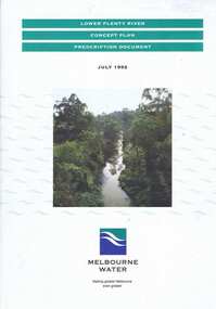 Greensborough Historical Society
Book, Lower Plenty River concept plan: prescription document, 1992_07
Draft concept plan prepared. by Brett Cheatley, Malcolm Warren and Ian Womersley, Parks and Waterways Planning Division, Melbourne Water. Includes management areas and key strategies for the Lower Plenty River.Book, mainly black and white print, colour photographs and plans, 66 pages. 3 copiesplenty river, melbourne water, lower plenty river -
 Melbourne Legacy
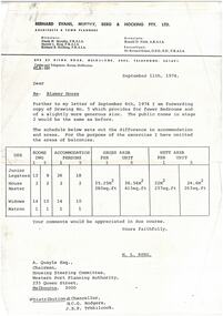
Document, Re: Blamey House
Letter dated 11 September 1974 from (Legatee) H.L. Berg of Bernard Evans, Murphy, Berg & Hocking Pty. Ltd., Architects & Town Planners, to Legatee A. Quayle, Chairman of the Housing Steering Committee. The plan (01677.2) is undated and unnumbered, but produced by the same architects and sitting next to the letter in the file. The letter refers to a Drawing No.5 and sets out the difference in accommodation and areas from Drawing No. 1. It is unclear whether the plan is No.1 or No.5. At this time Melbourne Legacy was considering demolishing Blamey House and developing the site to build units to accommodate senior children initially and ultimately widows. (Cat. No. 01676). This was never put into practice.Part of the history of Melbourne Legacy's involvement with residential care for children.Photocopied unsigned letter and an architectural plan. residences, blamey house -
 Kew Historical Society Inc
Plan, Melbourne and Metropolitan Board of Works, Melbourne & Metropolitan Board of Works : Borough of Kew : Detail Plan No.1294 & 1295, 1904
The Melbourne and Metropolitan Board of Works (MMBW) plans were produced from the 1890s to the 1950s. They were crucial to the design and development of Melbourne's sewerage and drainage system. The plans, at a scale of 40 feet to 1 inch (1:480), provide a detailed historical record of Melbourne streetscapes and environmental features. Each plan covers one or two street blocks (roughly six streets), showing details of buildings, including garden layouts and ownership boundaries, and features such as laneways, drains, bridges, parks, municipal boundaries and other prominent landmarks as they existed at the time each plan was produced. (Source: State Library of Victoria). This plan forms part of a large group of MMBW plans and maps that was donated to the Society by the Mr Poulter, City Engineer of the City of Kew in 1989. Within this collection, thirty-five hand-coloured plans, backed with linen, are of statewide significance as they include annotations that provide details of construction materials used in buildings in the first decade of the 20th century as well as additional information about land ownership and usage. The copies in the Public Record Office Victoria and the State Library of Victoria are monochrome versions which do not denote building materials so that the maps in this collection are invaluable and unique tools for researchers and heritage consultants. A number of the plans are not held in the collection of the State Library of Victoria so they have the additional attribute of rarity.Original survey plan, issued by the MMBW to a contractor with responsibility for constructing sewers in the area identified on the plan within the Borough of Kew. The plan was at some stage hand-coloured, possibly by the contractor, but more likely by officers working in the Engineering Department of the Borough and later Town, then City of Kew. The hand-coloured sections of buildings on the plan were used to denote masonry or brick constructions (pink), weatherboard constructions (yellow), and public buildings (grey).The streets and built structures in MMBW Detail Plan 1294 & 1295 were surveyed in 1903 and released to contractors in 1904. This plan is one of two in the collection where the lithographers amalgamated two separate plans. Both plans include sections of Studley Park. Dominating the south and west corners of Kew Junction are the Clifton and Kew Hotels. The Kew Hotel, owned by Patrick O’Shaughnessy was one of the oldest in Kew. MMBW plans were amended over time to take account of new subdivisions such as that which created Merrion Place. Of the four mansions shown in Studley Park Road, three remain – ‘Field Place’, the home of Frances Henty, ‘Leaghur’ and ‘Darley’. ‘Byram’ (later ‘Goathland’, then ‘Tara Hall’) was an architectural marvel. Designed in 1888 by E.G. Kilburn for the paper magnate George Ramsden, it was demolished in 1960. While an earlier sale of the southern section of Byram had created Tara Avenue in 1927, the demolition of the house in 1960 enabled the extension of Tara Avenue northward.melbourne and metropolitan board of works, detail plans, mmbw 1294, mmbw 1295, cartography -
 Federation University Historical Collection
Map - Plan, E.J. Dunn, Bungal County of Grant Parish Plan
E.J. Dunn was the surveyor of this parish plan.Colour geological plan of Bungal in the County of Grant, Victoria. The areas circled in red ar craters.plan, bungal, bungeltap, black horse co. egerton, egerton, mount egerton, sister rose shaft, south learmonth co, kerrit bareet, bungaeeltap, yaloak, eastern moorabool river, corong, bungal station preemptive right, lal lal, western moorabool river, moorabool rover, borhoneychurck, mount egerton battery, bungal creek -
University of Melbourne, Burnley Campus Archives
Plan (Item), Repairs etc. to Caretaker's Cottage, Horticultural Gardens, Burnley Melb, 1933
Appears to be the cottage at the western end of the site, near the level crossing, occupied by the stockman (George Hudson ,followed by Tom Kennedy, then George Manley) Plan signed by J.B. McLean, District Architect, 24.1.33caretaker's cottage, burnley gardens, stockman's cottage, george hudson, tom kennedy, george manley, j.b. mclean -
 Yarra Ranges Regional Museum
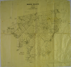
Map, H J Green, Acting Govt. Printer, Wandin Yallock, County of Evelyn (Parish Plan), c. 1910 - 1920
Parish Plan of Wandin Yallock. Location of Silvan Reservoir marked in ink on map.Parish Plan of Wandin Yallock. Location of Silvan Reservoir marked in ink on map. wandin yallock, maps -
 Bendigo Military Museum
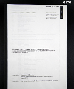
Administrative record - Design Brief for Refurbishment of Facilities at "Fortuna Villa", Peter Jordan Architects, 55 Clements St, South Yarra, Vic 3141, 1994
Refurbishment Plans for building Works at Fortuna Villa, Building 23 (Ordinary Ranks Accommodation Barracks) were completed, Building 8 works were never commenced.Plastic Covered Book, A4 Pages, Building plansPeter Jordan Architects, 55 Clements St, South Yarra, Vic, 3141royal australian survey corps, rasvy, fortuna, army survey regiment, army svy regt, asr -
 Kew Historical Society Inc
Plan, Melbourne & Metropolitan Board of Works / Borough of Kew, Detail Plan No.1593, 1905
The Melbourne and Metropolitan Board of Works (MMBW) plans were produced from the 1890s to the 1950s. They were crucial to the design and development of Melbourne's sewerage and drainage system. The plans, at a scale of 40 feet to 1 inch (1:480), provide a detailed historical record of Melbourne streetscapes and environmental features. Each plan covers one or two street blocks (roughly six streets), showing details of buildings, including garden layouts and ownership boundaries, and features such as laneways, drains, bridges, parks, municipal boundaries and other prominent landmarks as they existed at the time each plan was produced. (Source: State Library of Victoria)This plan forms part of a large group of MMBW plans and maps that was donated to the Society by the Mr Poulter, City Engineer of the City of Kew in 1989. Within this collection, thirty-five hand-coloured plans, backed with linen, are of statewide significance as they include annotations that provide details of construction materials used in buildings in the first decade of the 20th century as well as additional information about land ownership and usage. The copies in the Public Record Office Victoria and the State Library of Victoria are monochrome versions which do not denote building materials so that the maps in this collection are invaluable and unique tools for researchers and heritage consultants. A number of the plans are not held in the collection of the State Library of Victoria so they have the additional attribute of rarity.Original survey plan, issued by the MMBW to a contractor with responsibility for constructing sewers in the area identified on the plan within the Borough of Kew. The plan was at some stage hand-coloured, possibly by the contractor, but more likely by officers working in the Engineering Department of the Borough and later Town, then City of Kew. The hand-coloured sections of buildings on the plan were used to denote masonry or brick constructions (pink), weatherboard constructions (yellow), and public buildings (grey). The laborious task of hand-tinting these Board of Works plans was not without hazards as is evidenced by Plan No. 1593. On the Plan, the original colourist spilt black and green ink, partially obscuring some parts. The most obvious casualty is ‘Clifton’ located on the corner of Cotham Road and Park Street [now Adeney Avenue]. Included in this Plan, and outlined in pink is that part of the section that the contracting engineer was tasked with completing. This included sewering on both sides of this part of Cotham Road, but excluded properties such as ‘Glendonald’ and ‘Monnington’. This area was to undergo a series of subdivisions including the ‘Clifton Estate’, which created housing lots on Adeney Avenue and Florence Avenue in 1916. The most notable occupant of Clifton was William Adeney [died 1893], a pioneer of Camperdown, after which Park Street was later renamed.melbourne and metropolitan board of works, detail plans, survey plans - borough of kew, mmbw 1593, cartography -
 Kew Historical Society Inc
Plan, Melbourne & Metropolitan Board of Works : Borough of Kew : Detail Plan No.1291, 1905
The Melbourne and Metropolitan Board of Works (MMBW) plans were produced from the 1890s to the 1950s. They were crucial to the design and development of Melbourne's sewerage and drainage system. The plans, at a scale of 40 feet to 1 inch (1:480), provide a detailed historical record of Melbourne streetscapes and environmental features. Each plan covers one or two street blocks (roughly six streets), showing details of buildings, including garden layouts and ownership boundaries, and features such as laneways, drains, bridges, parks, municipal boundaries and other prominent landmarks as they existed at the time each plan was produced. (Source: State Library of Victoria). This plan forms part of a large group of MMBW plans and maps that was donated to the Society by the Mr Poulter, City Engineer of the City of Kew in 1989. Within this collection, thirty-five hand-coloured plans, backed with linen, are of statewide significance as they include annotations that provide details of construction materials used in buildings in the first decade of the 20th century as well as additional information about land ownership and usage. The copies in the Public Record Office Victoria and the State Library of Victoria are monochrome versions which do not denote building materials so that the maps in this collection are invaluable and unique tools for researchers and heritage consultants. A number of the plans are not held in the collection of the State Library of Victoria so they have the additional attribute of rarity.Original survey plan, issued by the MMBW to a contractor with responsibility for constructing sewers in the area identified on the plan within the Borough of Kew. The plan was at some stage hand-coloured, possibly by the contractor, but more likely by officers working in the Engineering Department of the Borough and later Town, then City of Kew. The hand-coloured sections of buildings on the plan were used to denote masonry or brick constructions (pink), weatherboard constructions (yellow), and public buildings (grey). A detail plan of part of Studley Park bordered by the major streets of Hodgson Street, Stevenson Street and Studley Park Road. Included on the plan are a number of significant Studley Park mansions in existence at the beginning of the 20th century. The unnamed street shown in the middle of the plan is McEvoy Street. The most important house still extant is Campion House, formerly named Dalsraith [Dalswraith] and Glendalough, owned since the 1940s by the Society of Jesus. Campion House can be seen on the corner of Hodgson and Studley Park Road. Its stables at the rear of the block have now been incorporated into a contemporary residence. An interesting feature of the plan is the 1910 annotation by Ed Seitz, professional designing engineer. Is Seitz the contractor who modified the MMBW original?melbourne and metropolitan board of works, detail plans, mmbw 1291, cartography -
Port Melbourne Historical & Preservation Society
Plan - Cottage, c. 1865
IF Toll Gate Plan, refer Minute Book (Reg 234) September 1865 IF Poundkeeper's Cottage, see 7 December, 1865 referring to preparation of plan for house for Poundkeeper, (guesswork!)Front, side and section elevations and floor plan for unidentified cottage and gate, 1860s. Possibly tip tender.built environment - domestic -
Federation University Historical Collection
Plan - Main Street Plan, John Carruthers, Plan of Main Street Ballarat done by J Carruthers 1858, 1858
This is an Historical plan of Ballarat and gives us a look back in time.long thin hand drawn plan of Main Street Ballarat on brown wax paper.j carruthers, main st, main street, free trade hotel, eureka street, specimen hill road, humffray street, star hotel, old kaiser hotel, golden age hotel, royal mail hotel, john carruthers -
 Kew Historical Society Inc
Plan, Melbourne & Metropolitan Board of Works : Borough of Kew : Detail Plan No.1350, 1910
The Melbourne and Metropolitan Board of Works (MMBW) plans were produced from the 1890s to the 1950s. They were crucial to the design and development of Melbourne's sewerage and drainage system. The plans, at a scale of 40 feet to 1 inch (1:480), provide a detailed historical record of Melbourne streetscapes and environmental features. Each plan covers one or two street blocks (roughly six streets), showing details of buildings, including garden layouts and ownership boundaries, and features such as laneways, drains, bridges, parks, municipal boundaries and other prominent landmarks as they existed at the time each plan was produced. (Source: State Library of Victoria). This plan forms part of a large group of MMBW plans and maps that was donated to the Society by the Mr Poulter, City Engineer of the City of Kew in 1989. Within this collection, thirty-five hand-coloured plans, backed with linen, are of statewide significance as they include annotations that provide details of construction materials used in buildings in the first decade of the 20th century as well as additional information about land ownership and usage. The copies in the Public Record Office Victoria and the State Library of Victoria are monochrome versions which do not denote building materials so that the maps in this collection are invaluable and unique tools for researchers and heritage consultants. A number of the plans are not held in the collection of the State Library of Victoria so they have the additional attribute of rarity.Original survey plan, issued by the MMBW to a contractor with responsibility for constructing sewers in the area identified on the plan within the Borough of Kew. The plan was at some stage hand-coloured, possibly by the contractor, but more likely by officers working in the Engineering Department of the Borough and later Town, then City of Kew. The hand-coloured sections of buildings on the plan were used to denote masonry or brick constructions (pink), weatherboard constructions (yellow), and public buildings (grey). MMBW Plan No. 1350 depicts the western end of Studley Park on the north side of the Studley Park Road. ‘Raheen’, then the home of Sir Henry Wrixon is named, the plan identifying those parts of the house that were built of brick and timber. The two houses between Raheen and the River Yarra are also shown. Other parts of the plan show neighbouring streets: Yarra Street, Studley Park Avenue, Studley Street and Fenwick Street. Each, apart from Fenwick Street was subsequently renamed. At the corner of Fenwick and Stawell Streets, the home of Joseph Butterworth Coombs, later called ‘Hope Mansell’, is represented but unnamed.melbourne and metropolitan board of works, detail plans, mmbw 1350, cartography -
 Greensborough Historical Society
Planning Document, Shire of Diamond Valley, Civic Centre Redevelopment 1992, 1992_08
6 plans for the proposed redevelopment of the Shire of Diamond Valley offices in Civic Drive, now the offices of Nillumbik Council. Shire of Diamond Valley existed from 1964 to 1994.6 planning drawings, black ink on white paper.shire of diamond valley, nillumbik council -
 Greensborough Historical Society
Plan, Watsonia High School Library: floor plan 1971, 1971_
In the early 1970s "Commonwealth Libraries" were funded in secondary schools. This is the proposed plan for the Watsonia High School Library.An example of school library plans from the 1970s.3 copies of a one-page floor plan and front elevation of building.Written on front "Watsonia"watsonia high school, commonwealth libraries -
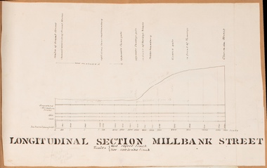 Bacchus Marsh & District Historical Society
Drawing, Longitudinal Section Millbank Street Bacchus Marsh circa 1905
Millbank Street is a short street located close to the central business and shopping area of Bacchus Marsh. In the early 1900s works to improve the drainage of the street were discussed and planned by Bacchus Marsh Shire Council. This plan is most probably the plan discussed at a Shire Council meeting in April 1905. Single page plan showing a longitudinal section view of MIllbank Street running from Clarinda Street to Grant Street in Bacchus Marsh. The names of Millbank Street property owners, Cain, Shelley, Oliver and Ramsay are marked on this plan. Scale: Vertical 10 feet to 1 inch. Horizontal: 100 links to 1 inch Part of a set of maps which are pasted into a bound volume containing 76 maps or plans in total. High resolution digital image stored on BMDHS computer network. bacchus marsh victoria maps, millbank street bacchus marsh -
National Wool Museum
Stencil
COLOMBO PLANwool - transportation wool sales export - wool, wool - transportation, wool sales, export - wool -
 Rutherglen Historical Society
Aperture Card microfilm, Victorian Land Tiltes Office, Parish Plan Barnawartha North Schedule (Duplicate)
Town layout of Barnawarthacard with a single microfilm insertMetric Planschedule -
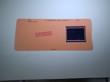 Rutherglen Historical Society
Aperture Card microfilm, Victorian Land Tiltes Office, Parish Plan Barnawartha North Schedule
Town layout of Barnawarthacard with a single microfilm insertMetric Planschedule -
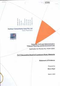 Greensborough Historical Society
Document, Statement of evidence: VCAT Application P2461/2003, prep. by Marco Negri, Contour Consultants Aust Pty Ltd, 2004_03
Lawyers for the City of Banyule commissioned a report on the town planning implications of a proposal to construct a multi-level building on land at the corner of Lambourn and Devonshire Roads Watsonia, relating to the Council's refusal of a permit and the subsequent hearing by VCAT22 p., black & white with col. plans.watsonia, lambourn road watsonia, devonshire road watsonia