Showing 2472 items matching " township"
-
 Clunes Museum
Plan
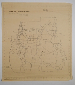
PLAN HAS AN ATTACHED HAND PRINTED CARD WITH INFORMATION REGARDING SITES. THIS HAS BEEN ADDED AT A MUCH LATER DATE.1 PAGE - AN EARLY, UNDATED PLAN OF THE TOWNSHIP OF CLUNES, COUNTY OF TALBOT, SHOWING REDUCED LEVELS AND CHAIN SURVEY OF ALL SECTIONSlocal history, plans -
Clunes Museum
Ephemera - STICKER
Stickers are traditionally placed on vehicle to promote destination/s traveled. This sticker essentially promotes tourism to Clunes and images gives clues about the town.Coloured adhesive backed sticker on the shape of a shield. 3 x images - Clunes township, a sheep, windlass over mine shaftClunes Vicsouvenir, sticker -
 Linton and District Historical Society Inc
Photograph, Grenville Standard Building, Clyde Street, Linton
Sepia photograph of Grenville Standard building, with view of railway station and other buildings spread across open land at east of township."S E Surman".grenville standard [newspaper], buildings, linton railway station, clyde street linton -
 Lakes Entrance Historical Society
Photograph - Sunnyside, Mt Wills, Omeo Victoria, 1907 c
Black and white photograph of the township of Sunnyside which came into existence after gold was discovered at Mt Wills north of Omeo Victoriahistoric sites, mines and mining -
Bendigo Historical Society Inc.
Map - CAMPBELL COLLECTION: BENDIGO AND DISTRICT MAPS, 1962
Map. Mandurang, County of Bendigo. Scale 40 chains to 1 inch. Sandhurst, Strathfieldsaye, Sedgwick, Sutton Grange, Ravenswood, Lockwood, Township of Kangaroo Flat, Township of Mandurang. By Authority A.C. Brooks, Government Printer, Melbourne. Drawn and Reproduced at the Department of Lands and Survey, Melbourne,1962, Price 2/-. (number 401 in map cupboard 1)A.C. Brooks, Government Printer.map, bendigo, allotments -
 Bendigo Historical Society Inc.
Photograph - HARRY BIGGS COLLECTION: LONG GULLY TOWNSHIP
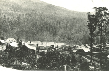
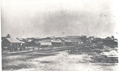
Photograph. Harry Biggs Collection. 1 black & white photo of Long Gully township looking from Eaglehawk towards Bendigo near the bridge. On 1 shop can be seen P Pentreath. A wooden bridge can be seen over the creek. Long Gully Township looking from Eaglehawk to Bendigo near bridge (written on the back).photograph, streetscape, long gully, harry biggs collection, long gully township -
 Bendigo Historical Society Inc.
Map - CAMPBELL COLLECTION: BENDIGO AND DISTRICT MAPS, 21-8-1972
Map. Shire of Strathfieldsaye, Locality Plan. Scale I inch=1 mile. Shire of Huntly, Shire of McIvor, City of Bendigo, Shire of Marong, Shire of Maldon, Shire of Metcalfe. Lake Eppalock. Mileage markers on some roads. Melbourne to Bendigo Railway Line, Big Hill Tunnel, Mt.Herbert 1596.Axedale Township, Strathfieldsaye Township.M.Higgs 21-8-1972map, bendigo, locality plan -
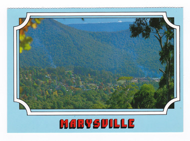 Marysville & District Historical Society
Postcard (item) - Colour postcard, Scancolor (Australia) Pty Ltd, Marysville, Pre 2009
A colour photograph of the view of Marysville from Cumberland lookout.A colour photograph of the view of Marysville from Cumberland lookout. This postcard was produced by Scancolor Australia as a souvenir of Marysville.MARYSVILLE Victoria - Australia View to Marysville township from Cumberland/ lookout. scancolor Australia (03) 555 1944 CS 4064marysville, cumberland lookout, victoria, scancolor australia, postcard, souvenir -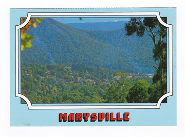
 Orbost & District Historical Society
black and white photograph, 1960s - 1970s
This photograph shows the former Orbost Police Station in Wolseley Street before it was demolished and a new larger brick building was built behind it in Lawson Lane - late 1980s.This is a pictorial record of a significant community building no longer existing.A large black / white photograph of the Orbost township police station. It is a weatherboard building surrounded by trees. A sign "POLICE" is hanging from a pole.on back - " Orbost Police Station in Wolseley Street, Donated by Debbie Hall 31/8/94"orbost-police-station -
Clunes Museum
Document
.1 DAYLESFORD AND HEPBURN SPRINGS 14 PAGES, ACCOMMODATION, SITES, CHURCHES, MAPS .2 TALBOT TOWNSHIP, SHORT HISTORY AND POINTS OF INTERESTtalbot, daylesford hepburn springs, history maps points of interest -
Clunes Museum
Map - MAPS
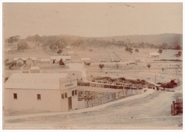
A MAP OF CLUNES TOWNSHIP. ORIGINAL AND COPY. ALL STREETS WITH ALLOTMENT NUMBERS CRESWICK CREEK - KILKENNY CREEK - BALLARAT TO MARYBOROUGH RAILWAY LINE.CLUNESlocal history, document, maps, clunes township -
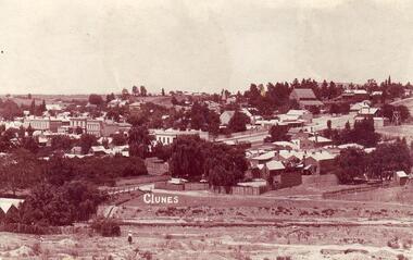 Clunes Museum
Photograph, 1911
COPY OF POSTCARD OF TOWNSHIP OF CLUNES 1911, TAKEN FROM SCENIC DRIVE, SHOWING FRASER STRRET BUILDINGS, ST PAUL'S CHURCH ETC.CLUNESlocal history, document, postcard, clunes township -
Clunes Museum
Print - DISPLAY PANEL
COPIES OF DISPLAY PANELS DONATED TO THE PEOPLE OF CLUNES BY THE HUGH WILLIAMSON FOUNDATION.1 INTERPRETIVE DISPLAY PANEL DEPICTING THE DISCOVERY OF GOLD AND THE DEVELOPMENT OF THE TOWNSHIP OF CLUNES IN A WOODEN FRAME .2 LAMINATED COPY OF THE DISPLAY PANELlocal history, civic momentoes, presentations., williamson, hugh foundation -
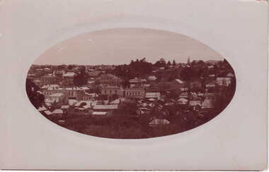 Clunes Museum
photograph
OVAL PHOTOGRAPH - POST CARD PHOTOGRAPH, OF CLUNES TOWNSHIP. .1 ORIGINAL POSTCARD, OVAL PHOTOGRAPH ON GRAY CARDBOARD .2.3 PHOTOCOPIES OF THE POSTARDlocal history, photography, photographs, clunes township -
Southern Sherbrooke Historical Society Inc.
Book - Local History, Longman Cheshire Pty Ltd, Story Of The Dandenongs, First published 1959, thisa copy reprinted 1982
pp.xv, 415, hardback, appendices, index of names. History of exploration & development,local government & services and the townships of the Dandenong Ranges, 1838-1958.dandenong ranges, local government, white settlement -
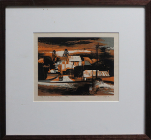 Federation University Art Collection
Work on paper - Artwork - Printmaking, Jack, Kenneth, 'Long Gully near Bendigo' Kenneth Jack, 1960
Framed Limited Edition print showing a mining township at Long Gully, Bendigo. Donated through the Australian Gifts Programme by Katherine Littlewood.29/40goldfields, poppet head, bendigo, long gully, tram -
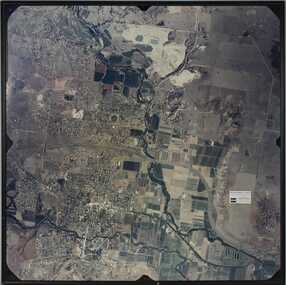 Bacchus Marsh & District Historical Society
Photograph, Aerial image of Bacchus Marsh and Darley in 1994
A whole of town and nearby area aerial image of Bacchus Marsh produced for display in the Arbee Real Estate Agency premises in Main Street, Bacchus Marsh.A large framed colour aerial photograph showing the township of Bacchus Marsh, the neighbouring smaller community of Darley, and the nearby areas of both places. "Bacchus Marsh - Darley. Aerial Photo 27 November, 1994. Presented by Arbee Real Estate "Professionals"'arbee real estate agency bacchus marsh, aerial views bacchus marsh vic. -
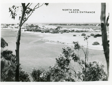 Lakes Entrance Historical Society
Postcard - North Arm Lakes Entrance, 1945c
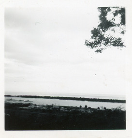
Photo taken soon after extensive dredging operations when tons of sand were dumped on low lying land at western end of town.Black and white small format postcard of the North Arm. It shows the township between North Arm and Cunninghame Arm. Lakes Entrance VictoriaNorth Arm Lakes Entrancewaterways, topography -
 Lakes Entrance Historical Society
Photograph - Cunninghame Arm, Fraser, Nancy, 1970c
Black and white photograph of a distant view township and Cunninghame Arm and scrub covered hummocks of southern shore in distance. Lakes Entrance Victoria topography, waterways -
 Lakes Entrance Historical Society
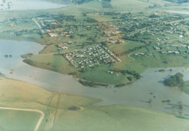
Photograph - Mitchell River in flood Bairnsdale Victoria, 1/04/1990 12:00:00 AM
There was a deluge overnight in headwaters of Mitchell and Avon Rivers so the rivers rose overnight and flooded low lying areasColour aerial photograph of Mitchell River in flood showing Clifton Waters Village in centre and township of Wy Yung near Bairnsdale Victoriarivers, floods -
 Lakes Entrance Historical Society
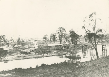
Photograph - Mitchell River Bairnsdale Victoria, F Cornell, 1870
Black and white photograph of the punt on the Mitchell River and the first bridge under construction. In distance can be seen the growing township of Bairnsdale Victoriaboats and boating, businesses, rivers -
 Lakes Entrance Historical Society
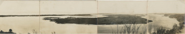
Postcard, Reeves Channel, Rigby Island, the entrance, Bullock Island , Lakes Entrance Victoria, 1920 c
Views of Gippsland Lakes from Jemmy's Point Lakes EntranceBlack and white panoramic folding postcard of the Gippsland Lakes including Reeves Channel, Rigby Island, the entrance, Bullock Island and Lakes Entrance township taken from Jemmys Point Lakes Entrance Victoria. Also panoramic postcard view from southern part of Rigby Island to Lakes Entrance township. And a third postcard "KALIMNA COVE LAKES ENTRANCE"waterways, gippsland lakes -
 Orbost & District Historical Society
aerial photograph, 1970's
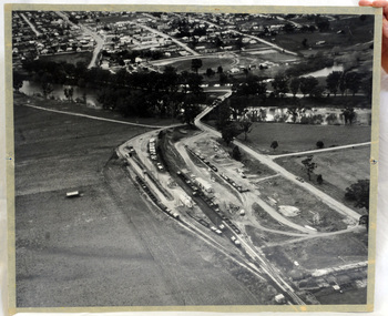
This photograph was taken prior to the closure of the Orbost -Bairnsdale freight line in 1987.The Orbost-Bairnsdale railway initially played a crucial role in developing agricultural industries in Gippsland as well as tourism. It opened in 1916 and operated until 1987, principally carrying timber and farming produce. In the early days of the railway's operation dedicated passenger trains ran but these ceased by the 1930s. The line was completely closed to freightage in 1987.The track infrastructure was dismantled in 1994 and has been redeveloped as the East Gippsland Rail Trail.A large black and white aerial photograph of Orbost Railway Station in the foreground and the Orbost township in the background. It has been pasted onto a piece of Masonite. railway photography orbost, railway photography orbost -
 Phillip Island and District Historical Society Inc.
Photograph, Early 20th Century
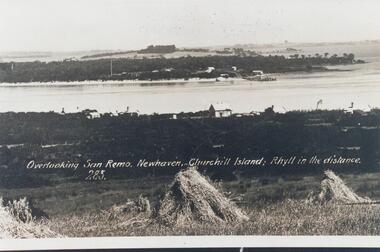
One of 20 photographs/postcards donated by Mary KarneyBlack & White copy of postcard. View taken from San Remo overlooking township across the water to Newhaven, with Churchill Island and Rhyll in the background."Overlooking San Remo, Newhaven, Churchill Island; Rhyll in the distance. 285"san remo, newhaven phillip island, churchill island, rhyll phillip island, mary karney -
Glenelg Shire Council Cultural Collection
Postcard - Postcard - Nelson, Victoria, n.d
Coloured photo postcard, aerial view of Nelson, Victoria, showing the bridge, township and river mouth. Rose Series De Luxe colorview NO 1213Back: Maker details. 'Aerial view of Nelson Victoria'postcard, nelson -
Glenelg Shire Council Cultural Collection
Certificate - Certificate - Syd Cuffe, Town Crier, 14/07/1997
Syd Cuffe was the Portland Town Crier from 1983 to 2013. The role of Town Crier was created for Syd Cuffe in 1983 in the lead up to Portland’s 150th anniversary celebrations held in 1984-85. 200 items from Mr. Cuffe’s estate were donated to the Glenelg Shire Cultural Collection. The items relate to his town crying activities and community work across the Shire and further afield.Certificate of welcome from township of Malden, to Syd Cuffe, July 14 1997. Grey card, black print, red and black seal of Malden. -
 Kiewa Valley Historical Society
Map - Kiewa Hydro Electric Works Area
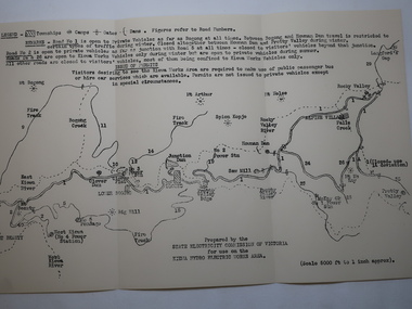
An early map of the Kiewa Hydro Electric Scheme Works Area prepared by the SECV for use when requesting access to the area. The regulations are printed regarding permits.During construction of the KHES there were restrictions on access to the area. This map identifies the land marks and states the regulations for entry to the area.Black and white map folded into three showing a legend with the townships, camps, gates and dams marked.Also indicating the roads, rivers, mountains and infrastructure of the KHES. khes works area, map of khes -
 Kiewa Valley Historical Society
Photos x53 - Ewan Stebbins Collection
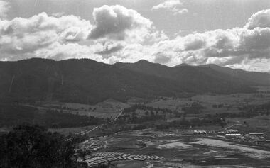
Photos were digitized (instead of printed) onto CDs for preservation, easy storage and enabling multiple copies.These photos are a record of the early days of the Kiewa Hydro Electric Scheme including the town of Mt Beauty in the late 1940s to early 1950s Bronwyn Gray inherited these photos of Mt Beauty and the construction of the KHES. Her uncle Ewan Stebbins puchased a piece of furniture from a garage sale in Boston Rd., Torquay in 1981. The developed film were photos of Mt Beauty and surrounding area. He was an SEC employee and knew the area well.Case is hard plastic, black on the back and clear on the front. The 53 black and white photos are of Mt Beauty township and the Kiewa Hydro Electric Scheme. On the CD in black texta: "Mt Beauty / Film found in / furniture from house / in Boston Rd. / Torquay in 1981" Added in blue texta: "MTB 001 - MTB 053"mt beauty c1949, bogong c1949, stebbins photo collection -
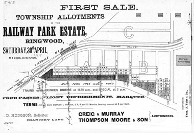 Ringwood and District Historical Society
Flyer, Subdivision advertisement - Railway Park Estate, Ringwood, Victoria - circa 1887
Photocopy of advertisement for auction sale of township allotments in Railway Park Estate, Ringwood, on Saturday 30th April (1887?), with terms of sale and location map.Subdivision map includes Pitt Street and Main Ferntree Gully Road (later Bedford Road). (Agents) Greig & Murray, Thompson Moore & Son, Auctioneers.