Showing 534 items
matching agricultural district
-
 Eltham District Historical Society Inc
Photograph - Digital Photograph, Alan King, Blue Lake, Plenty Gorge Park, 2008
A quarry was transformed into the Blue Lake. Published: Nillumbik Now and Then / Marguerite Marshall 2008; photographs Alan King with Marguerite Marshall.; p179 The dramatic steep-sided Plenty Gorge lies along the divide of two geological areas, and separates the Nillumbik Shire and the City of Whittlesea. On the Nillumbik side are undulating hills and sedimentary rock, and in Whittlesea, lies a basalt plain formed by volcanic action up to two million years ago. This provides the Plenty Gorge Park with diverse vegetation and habitats, making it one of Greater Melbourne’s most important refuges for threatened and significant species. The park, established in 1986, consists of around 1350 hectares, and extends 11 kilometres along the Plenty River, from Greensborough to Mernda. It provides a wildlife corridor for around 500 native plant and 280 animal species. The area’s plentiful food and water attracted the Wurundjeri Aboriginal people and then European settlers. By 1837 squatters had claimed large runs of land for their sheep and cattle. The Plenty Valley was among the first in the Port Phillip District to be settled - mainly in the less heavily timbered west - and was proclaimed a settled district in 1841.But by the late 1880s, the settlers’ extensive land clearing for animal grazing, then agriculture, depleted the Wurundjeri’s traditional food sources, which helped to drive them away. Many Wurundjeri artefacts remain (now government protected), and so far 57 sites have been identified in the park, including scarred trees, burial areas and stone artefacts. Pioneer life could be very hard because of isolation, flooding, bushfires and bushrangers. Following the Black Thursday bushfires of 1851, basalt was quarried to build more fire-resistant homes. Gold discoveries in the early 1850s swelled the population, particularly around Smugglers Gully; but food production made more of an impact. In the late 1850s wheat production supplanted grazing. In the 1860s the government made small holdings available to poorer settlers. These had the greatest effect on the district, particularly in Doreen and Yarrambat, where orchards were established from the 1880s to 1914. Links with a prominent early family are the remains of Stuchbery Farm, by the river’s edge bounded by Smugglers Gully to the north and La Trobe Road, Yarrambat, to the east. The Stuchberys moved to the valley in 1890, and the family still lives in the area. In 1890, Alfred and Ada first lived in a tent where four children were born, then Alfred built the house and outbuildings around 1896. They planted an orchard, then a market garden, and developed a dairy. The family belonged to the local Methodist and tennis communities. Their grandson Walter, opened the Flying Scotsman Model Railway Museum in Yarrambat, which his widow, Vi, continues to run. Wal was also the Yarrambat CFA Captain for 22 years until 1987. Walter sold 24 hectares in 1976 for development - now Vista Court - and in 1990, the remaining 22.6 hectares for the park. Remaining are an early stone dairy and remnants of a stone barn, a pig sty and a well. Until it was destroyed by fire in 2003, a slab hut stood on the Happy Hollow Farm site, at the southern end of the park. The hut is thought to have been built in the Depression around 1893. This was a rare and late example of a slab hut with a domestic orchard close to Melbourne. Emmet Watmough and his family first occupied the hut, followed by a succession of families, until the Bell family bought it around 1948. There they led a subsistence lifestyle for 50 years, despite encroaching Melbourne suburbia. The Yellow Gum Recreation Area includes the Blue Lake, coloured turquoise at certain times of the year. Following the 1957 bushfires, this area was quarried by Reid Quarries Pty Ltd for Melbourne’s first skyscrapers, then by Boral Australia. However in the early 1970s water began seeping into the quarry forming the Blue Lake and the quarry was closed. The State Government bought the site in 1997 and opened it as a park in 1999.This collection of almost 130 photos about places and people within the Shire of Nillumbik, an urban and rural municipality in Melbourne's north, contributes to an understanding of the history of the Shire. Published in 2008 immediately prior to the Black Saturday bushfires of February 7, 2009, it documents sites that were impacted, and in some cases destroyed by the fires. It includes photographs taken especially for the publication, creating a unique time capsule representing the Shire in the early 21st century. It remains the most recent comprehenesive publication devoted to the Shire's history connecting local residents to the past. nillumbik now and then (marshall-king) collection, blue lake, plenty gorge park -
 Eltham District Historical Society Inc
Photograph - Digital Photograph, Marguerite Marshall, Stuchbery Farm dairy, 14 March 2008
Stuchbery Farm was situated on the Plenty River bounded by Smugglers Gully to the north and La trobe Road, Yarrambat, to the east. Alan and Ada Stutchbery moved to the valley in 1890, first living in a tent where four children were born. Alfred built a home and outbuildings around 1896. They planted an orchard, then a market garden and developed a dairy. Published: Nillumbik Now and Then / Marguerite Marshall 2008; photographs Alan King with Marguerite Marshall.; p179 The dramatic steep-sided Plenty Gorge lies along the divide of two geological areas, and separates the Nillumbik Shire and the City of Whittlesea. On the Nillumbik side are undulating hills and sedimentary rock, and in Whittlesea, lies a basalt plain formed by volcanic action up to two million years ago. This provides the Plenty Gorge Park with diverse vegetation and habitats, making it one of Greater Melbourne’s most important refuges for threatened and significant species. The park, established in 1986, consists of around 1350 hectares, and extends 11 kilometres along the Plenty River, from Greensborough to Mernda. It provides a wildlife corridor for around 500 native plant and 280 animal species. The area’s plentiful food and water attracted the Wurundjeri Aboriginal people and then European settlers. By 1837 squatters had claimed large runs of land for their sheep and cattle. The Plenty Valley was among the first in the Port Phillip District to be settled - mainly in the less heavily timbered west - and was proclaimed a settled district in 1841. But by the late 1880s, the settlers’ extensive land clearing for animal grazing, then agriculture, depleted the Wurundjeri’s traditional food sources, which helped to drive them away. Many Wurundjeri artefacts remain (now government protected), and so far 57 sites have been identified in the park, including scarred trees, burial areas and stone artefacts. Pioneer life could be very hard because of isolation, flooding, bushfires and bushrangers. Following the Black Thursday bushfires of 1851, basalt was quarried to build more fire-resistant homes. Gold discoveries in the early 1850s swelled the population, particularly around Smugglers Gully; but food production made more of an impact. In the late 1850s wheat production supplanted grazing. In the 1860s the government made small holdings available to poorer settlers. These had the greatest effect on the district, particularly in Doreen and Yarrambat, where orchards were established from the 1880s to 1914. Links with a prominent early family are the remains of Stuchbery Farm, by the river’s edge bounded by Smugglers Gully to the north and La Trobe Road, Yarrambat, to the east. The Stuchberys moved to the valley in 1890, and the family still lives in the area. In 1890, Alfred and Ada first lived in a tent where four children were born, then Alfred built the house and outbuildings around 1896. They planted an orchard, then a market garden, and developed a dairy. The family belonged to the local Methodist and tennis communities. Their grandson Walter, opened the Flying Scotsman Model Railway Museum in Yarrambat, which his widow, Vi, continues to run. Wal was also the Yarrambat CFA Captain for 22 years until 1987. Walter sold 24 hectares in 1976 for development - now Vista Court - and in 1990, the remaining 22.6 hectares for the park. Remaining are an early stone dairy and remnants of a stone barn, a pig sty and a well. Until it was destroyed by fire in 2003, a slab hut stood on the Happy Hollow Farm site, at the southern end of the park. The hut is thought to have been built in the Depression around 1893. This was a rare and late example of a slab hut with a domestic orchard close to Melbourne. Emmet Watmough and his family first occupied the hut, followed by a succession of families, until the Bell family bought it around 1948. There they led a subsistence lifestyle for 50 years, despite encroaching Melbourne suburbia. The Yellow Gum Recreation Area includes the Blue Lake, coloured turquoise at certain times of the year. Following the 1957 bushfires, this area was quarried by Reid Quarries Pty Ltd for Melbourne’s first skyscrapers, then by Boral Australia. However in the early 1970s water began seeping into the quarry forming the Blue Lake and the quarry was closed. The State Government bought the site in 1997 and opened it as a park in 1999.This collection of almost 130 photos about places and people within the Shire of Nillumbik, an urban and rural municipality in Melbourne's north, contributes to an understanding of the history of the Shire. Published in 2008 immediately prior to the Black Saturday bushfires of February 7, 2009, it documents sites that were impacted, and in some cases destroyed by the fires. It includes photographs taken especially for the publication, creating a unique time capsule representing the Shire in the early 21st century. It remains the most recent comprehenesive publication devoted to the Shire's history connecting local residents to the past. nillumbik now and then (marshall-king) collection, ada stuchbery, alan stuchbery, dairy, stuchbery farm, farm buildings, yarrambat, plenty gorge park -
 Nhill & District Historical Society Inc.
Book - Tattyara, Leslie James Blake, A History of Kaniva and District, 1981
This book has 373 pages of History of Kaniva and District containing maps, illustrations and portraits.The book has a yellow cover with black print and is in excellent condition.non-fictionThis book has 373 pages of History of Kaniva and District containing maps, illustrations and portraits.kaniva - history, author - les blake, australian history, tattyara, l.j. blake, agricultural colonies, australia - victoria -
Nhill & District Historical Society Inc.
Book - Wimmera Shire Centenary
Includes brief history of tribes (esp. Jardwa) in the Wimmera area; contact with settlers and decline of Aborigines; place names. Wimmera Shire Centenary: An historical Account. complied by Leslie James Blake, K. H. Lovett; 104 pages.jardwadjali language s27, language - vocabulary - place names., settlement and contacts - settlers., economic sectors - agriculture and horticulture - pastoral industry., settlement and contacts - colonisation - 1788-1850., politics and government - local government., wimmera (vic.) -- history., western victoria -
 Buninyong & District Historical Society
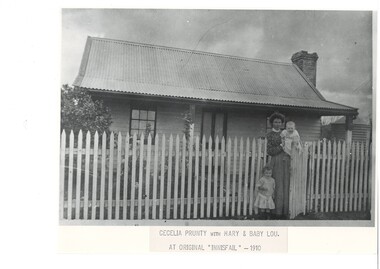
Photograph - B/W photograph, Copy of photograph of Cecilia Prunty outside "Innisfail" 1910
Cecilia was a Harrington born at Blue Bridge in the latter part of the 19th century. She married into the Prunty family and both families still have descendants living in the district in the 21st century.Both the Harrington and Prunty families were well known early settlers in the Clarendon area and had links to the railway and agricultureBlack and white copy of photograph of Cecelia Prunty and her two daughters Mary and Baby Lou at the gate of the original "Innisfail" 1910Cecilia Prunty with Mary and Baby Lou at original "Innisfail" - 1910clarendon, blue bridge, prunty family, harrington family, "innisfail" -
 Buninyong & District Historical Society
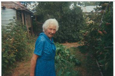
Photograph - Colour photograph, Colour photograph of May Williams (nee Coxall) 1994
May Williams was the granddaughter of Samuel Coxall who came to Buninyong in the 1860s and became a market gardener. May remembered her grandparents as a child and thus provided a link to the early days in Buninyong.May's interview for the Oral History of Buninyong provides details of the social, agricultural and cultural history of the township and surrounding districts from the mid 19th century until the end of the 20th century.Colour photograph of May Williams 1994May Williams (nee Coxall) Aged 91, February 1994 in her garden at Scotsburn, on day of Oral History Interviews, looking at Apple tree her father Samuel gave her on her wedding daybuninyong, coxall family, market gardens, webbville, scotsburn -
 Bendigo Historical Society Inc.
Document - LONG GULLY HISTORY GROUP COLLECTION: HISTORICAL GUIDE TO BENDIGO
Brochure with an invitation to visit Historical and Mining Museum in Mechanic's Institute, Eaglehawk. Drawing of poppet legs on the front with The Royal Historical Society of Victoria Bendigo Branch. Historical Guide to Bendigo including Self Tours of Bendigo's Famous Goldfields. Forward by John Hattam. Contributors are: H Biggs, Miss L J Parry, A Richardson, L C Bennetts and Edith Checcucci. Credits - The Bendigo Advertiser, Cambridge Press, Mines Department (Bendigo) and J R W Purves. Items include Bendigo Tramways Compiled by H Biggs, Early Bendigo Hotels Compiled by L C Bennetts, Eaglehawk Compiled by H Biggs, Noted Events Compiled by June Parry, The Bendigo Post Office Compiled by LC Bennetts, The Bendigo Goldfield. Introduction to Field and Guide to Some Famous Mines Compiled by A Richardson. Photos include: Pall Mall Bendigo, Ravenswood Homestead, An Early Battery at Kangaroo Flat, Historic High Street Golden Square, The Lonely Grave, Battery Tram c1888, Steam Tram c1892, Electric Tram c1903, The New Chum Railway Golden Square, United Hustlers and Redan Mine Sandhurst Road, Central Deborah Violet Street, Deborah Mine Quarry Hill, Deborah Mine 1000 ft level, First Motion Winding Engine at Central Deborah, Victoria Hill Area, and Looking south from New Chum Hill in 1890's. Also 11010.254, 255, 268, 288a, 288b, and 289.bendigo, history, long gully history group, the long gully history group - historical guide to bendigo, the royal historical society of victoria bendigo branch, historical and mining museum, mechanic's institute eaglehawk, librarian mechanic's institute, miss j parry, john hattam, h biggs, a richardson, l c bennetts, edith checcucci, bendigo advertiser, cambridge press, mines department (bendigo), j r w purves, mr a o'keefe, shire of marong, the sandhurst and eaglehawk tramway company, mr j taylor, mr j hanson, the bendigo tramway company, electric supply company, coliban water suply, juvenile industrial exhibition, geo lansell, cr a harkness, salvation army, vine and fruitgrowers association, decentralisation league, constable thomas ryan, miners association, art gallery, post office, miss broadfoot, bendigo hospital, opera company, bendigo development league, victorian women's franchise league, ana hall, the bendigonian, law courts, temperance hall, trades hall (old wardens court), roman catholic cathedral, shamrock hotel, bendigo philosophical society, old bendigonian society, bendigo fire brigade, bendigo volunteers to south african war, hawkins, porcupine inn, criterion hotel, royal hotel, bendigo hotel, black swan hotel, gillies bakery, hibernian hotel, sandhurst hotel, freemasons hotel, courthouse hotel, shamrock hotel, governor hotham, heffernan & crowley, new chum railway, victoria quartz, shenandoah, shamrock mine, hercules no 1 (originally pearl east), hercules new chum (late pearl), carlisle mine, mr arblaster, meurer, sandhurst bee, benevolent asylum, bendigo gas company, a lloyd, coliban water supply scheme, cr w v simons, eaglehawk council, j mouat, sir henry barkly, agricultural and horticultural exhibition, sandhurst and eaglehawk boroughs, cr john mcintyre, latham and watson's mine, galatea (model ship), st paul's church of england, rev g p despard, fine arts exhibition and exposition, bendigo rifle association, strathfieldsaye shire hall, corporate high school, bendigonian society, richard andrews, easter fair, g aspinall, j burnsides, sir h manners sutton, beehive stores, mining exchanges, bendigo water works, city family hotel, bendigo united friendly society medical institute and dispensary, benevolent asylum, jewish synagogue, masonic hall, school of mines, mr j h abbott, australian natives association, royal princess theatre, albion hall, central state school, high school, gravel hill state school, electricity commission, james mouat, warring natives, the rocks, joseph crook, gold discovery, marong district roads board, camp hotel, mr charles sherratt, city of bendigo, mt alexander north run, grice and heape, ravenswood, gibson and fenton, mrs john kennedy, mrs patrick farrel, mr j a paton, mr lachlan mclachlan, theatre royal, sir charles and lady hotham, harney's bridge, e j ennor, sandhurst fire brigade, the health of towns act, mr townsend, cornish & co, bendigo pottery, bendigo agricultural society, pike or pyke, baby health centre, sandhurst post office, government survey office, sandhurst trustees company, mr h b briston, savings bank, telegraph office, sir henry brougham lock, hon sir john nimmo, sandhurst public offices, the new prince of wales mine, new prince of wales no 2, the whip and jersey, lansell's big 180, new chum and victoria mine and battery, new chum railway, koch's pioneer, south new moon, catherine reef united, new moon, virginia mine, south belle vue, new chum railway, central nell gwynne, north nell gwynne, ironbark mine, new chum syncline, hercules, herculesl energetic, roberts & sons, harkness & co, horwoods, great southern, ulster, carlisle, cornish, new st mungo, duchess tribute, south devonshire, hopewell mine, saxby mine, mcnair & co, mr king, bourke and wills, sandhurst hotel, the dascombe nugget, victoria nugget, r r haverfield, ballerstedt, rae, wittscheibe, lazarus, cave and amos, bendigo amalgamated goldfields, bendigo mines limited, the deborah, north deborah, central deborah, the new red white and blue consolidated (big blue), union, lansell's new red white and blue 9later no 3 shaft), h harkness & co, thompson & co, central deborah, lansell's bendigo battery, north red white and blue, central red white and blue, roberts and sons, little 180 (originally lansell's 180 no 2 shaft), john brown knitwear factory, south ironbark originally victoria consols east shaft, ironbark (originally ironbark east shaft), manchester arms hotel, wattle gully mine chewton, hercules, old wheal-owl, central nell gwynne, gold mines hotel, bendigo city council, jack barker, the new chum syncline, the courier of the mines, telegraph office, bendigo cemetery, white hills cemetery, eaglehawk cemetery, kangaroo flat cemetery, new moon, suffolk united, north new moon, fortuna hustlers, buckell & jeffrey's, royal hustlers reserve no 2 (city and park shafts), jonathan harris, latham and watson, great hustlers, great extended hustlers, j hustler, latham, watson, tribute or pups shaft, bendigo's worst mining disaster, hustlers reef (old hustlers), hustlers reef no 1, lansell's comet, the old comet (cooper's claim), united hustlers and redan, comet hill state school, k k shaft, north or new hustlers (agnew hustler), johnson's no 3, south johnson's, lansell's sandhurst needle, cleopatra needle top, british american, collman and tacchi, south virginia, saddle reefs and spurs, pall mall bendigo, ravenswood homestead, an early battery at kangaroo flat, historic high street golden square, the lonely grave, battery tram c1888, steam tram c1892, electric tram c1903, teh new chum railway golden square, united hustlers and redan mine sandhurst road, central deborah violet street, deborah mine quarry hill, deborah mine 1000 ft level, first motion winding engine at central deborah, victoria hill area, looking south from new chum hill in 1890's -
Ringwood and District Historical Society
Container, Ringwood Garden Club Inc - Tub of Artefacts and Documents to be catalogued
RINGWOOD GARDEN CLUB INC. The following is a list of items that are stored at the RDHS Archive site, from the Ringwood Garden Club. This box of items does not include all the archival items from the Club, the Minutes will be kept at the home of the Archive Officer. Medal: From the Royal Horticultural Society of Victoria. Won at Box Hill show, in 1978. Badge: An early Ringwood Horticultural & Agricultural Society badge. Old Photograph: “Judging the Fruit Exhibits”, circa 1908. Certificate: 3rd. Prize at the 2009 Hanging Basket Competition, from the R.H.S.V. Shield: From the National Dahlia Society of Victoria, Annual Inter Society Championship In 1975. Won by the then: Ringwood & District Horticultural Garden Club. Tray: The Bill McDowell Perpetual Trophy for Amateur Cut Flowers: winners from 1973 to 1987. Old Photograph: From the Royal Agricultural Society of Victoria, awarded at the Royal Melbourne Show in 1947, First Prize, Ringwood. Certificate: From the Melbourne City Council: Festival of Progress, held in 1951, to Commemorate the Centenary of Victorian Government. Certificate of Merit: from past winners at shows. (5) Certificates: 2 unused Certificates of Merit, 1 unused Champion certificate. Garden Competition Certificates: from 1959 to 1981. Poster: Early Autumn Show poster displayed in shop Windows. Hortico Prize Certificates: 2 unused, $10.00 & $5.00 value. Tape Recording: Recorded history of the Ringwood Garden Club, talk given by the late Hugh McCall on 23/9/1996, Club’s centenary. Prize Cards: 41 First Prize” cards from Mrs. D. Holloway & 27 “Second Prize” cards, from 1956 to 1960. Prize Cards: 2 First Prize & 1 Second Prize card from Mrs. Holloway at the 1st. Heathmont Boy Scouts in 1958. Prize Cards: 4 Prize Cards from the Upwey & District Garden Club. 3 lsts., 12nd. Prize Card: from the Boronia & District H & A. Society: 1st. Prize, (no other information) Prize Card: from the R.H.S.V.: Second Prize for 1 Vase of Daffodils, Mr W Rosel. Prize Card: from the Dandenong Ranges Floral Festival, Easter Show, First Prize, Mrs Holloway in April, 1957 plus a Second Prize, same year. Prize Card: from the Mitcham Horticultural Society, Autumn Show, Mrs Holloway, 1 Bowl of Floating Flowers in 1958. Laminated Certificates: from the Great Victorian Hanging Basket Competition by the R.H.S.V. (no years mentioned) Club Syllabus: from 1980 to 2015. Photographs: from winners at our shows and judges at those shows. Ribbons: Ringwood Horticultural Society, 1962, Champion, Exhibit in Vegetables. Upwey & District Garden Club, 1977, Jubilee Carnival of Flowers. Ringwood garden Club, Vic. Large Dahlia Championships, 1983,6 Dahlias, D.V.’s. National Dahlia Soc. of Vic., Autumn Show, 1975, Inter-Societies Championship. Upwey & District Garden Club, 1980 Carnival of Flowers, Mountain Dist. Cham’s. “ “ “ “ , Spring Show, 1973. “ “ “ “ , Carnival of Flowers, 1984, Inter Society Exhibit. “ “ “ “ , “ “ “ , 1982. Best Exhibit. Healesville Garden Club: Autumn Show, Best Exhibit, Cut Flower Section. Ringwood Garden Club, Autumn Show, 1964, Best Exhibit in Vegetables. Upwey & District Garden Club, 1974 Carnival of Flowers. Ringwood Garden Club, Spring 1986, Best Exhibit in Junior Cookery. Ringwood & District Hort. & Graden Club, Autumn Show, 1974, Best Floral Art. Ringwood garden Club, Autumn 1989, Ringwood Amateur Dahlia Championship, Ringwood Horticultural Society, Autumn Show, 1963, Best Exhibit in Vegetables. Ringwood H & A Society: Autumn Show, 1957, Best Exhibit Floral Art. Ringwood & District Horticultural & Garden Club, Spring Show, 1973, Best Floral Art Exhibit. Upwey & District Garden Club, Carnival of Flowers, 1985. Mountain District Championships, Inter-Society Exhibit. Yarra Glen A. & H. Society Inc. Annual Show: small blue sash-style ribbon. Small Ribbons: from Victoria 150, a second (red) & 3rd. (green) Felt Badges: 1 green for Secretary: 1 blue for Judge. Rosette: 3rd. Prize at the Hanging Basket Competition in 2009. Blue Folder: contains photographs, prize cards, certificates, awards, etc. Albums: 4 photo, albums of garden shows, floral art, Spring Celebration photos and Newspaper articles. * All items placed in the container were placed there on 2nd. September, 2019. -
 Warrnambool and District Historical Society Inc.
Book, 055 Telephone Directory 1969, 1969
This telephone directory of 1969 has entries from the Camperdown, Casterton, Colac, Edenhope, Hamilton, Portland and Warrnambool districts. The directory came from the Nullawarre Post Office at the time when Charles Williams was the Post Master (mid 20th century) and delivered two runs of mail a day. His wife, Vida was the Post Mistress. Nullawarre is a small agricultural settlement 25 kilometres south east of Warrnambool and today has a general store, Post Office and school. This telephone directory, which has local provenance (Nullawarre Post Office), will be of great use to researchers as it contains the names and addresses of private individuals and businesses in the Western District of Victoria in 1969. It is also of interest as many of the entries give the names of the country properties at that time and the entries are listed separately under the names of the various towns. This is a soft-cover booklet of 392 pages. The front cover is multi-coloured and has a photograph of a parrot and the back cover has an advertisement in blue and white. There are 200 white pages and 192 pink pages of telephone numbers in Western Victoria in 1969. The printing throughout is black and the pages are very faded. communications, warrnambool, history of warrnambool, 055 telephone directory -
Lakes Entrance Historical Society
Book, Maffra and District Historical Society, I Remember- Reminiscences from Maffra Residents, 1977
A booklet of reminiscences from teb seniors living in the local community of Maffra Victoriasettlers, timber industry, township, agriculture -
 Wodonga & District Historical Society Inc
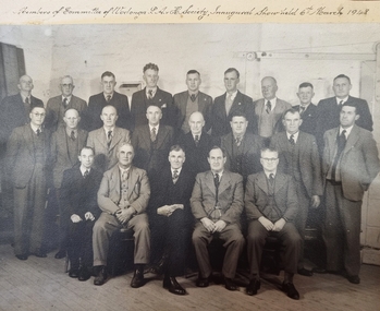
Photograph - Wodonga Show Society Inaugural Committee, 1948
In 1947 Shire President Cr. Charles F. Pollard called a public meeting for the purpose of discussing the forming of an Agricultural Society to raise funds for the proposed Wodonga Hospital. Cr. Pollard was the inaugural President of the Wodonga Show Society and joined by seven past Shire Presidents as part of an original 25 member Wodonga Show Society Committee. These committee members are captured in this photo. In addition to the committee, there were 150 members of the inaugural society. The first Wodonga Show was held on Saturday 6th March 1948. The catalogue for this event is included here. Forty district farmers guaranteed £400 in prize money; £321 was taken at the gate, and money from entry fees totalled £50. A profit of £50 was made for the Wodonga Hospital. This photograph is significant as it records the founding members of the first Pastoral, Agricultural and Horticultural Society in Wodonga.A framed black and white photograph of the members of the Inaugural Wodonga Show Committee. The unframed photo has a title handwritten in copperplate script at the top of the image. On the framed image, names have been typed an the left hand side.Handwritten above photo: Members of Committee of Wodonga P.A.H. Society Inaugural Show held 6th March 1948. Names typed with framed image:- Back R to L: Cliff Sheather, Charlie Ryan, Arnie Ford, Jack Hore, Bob Hall, Bill Richardson, Perc. Newbound, Peter Frawley Snr., Ernie Mann Centre Row L- R:- Sam Manning, Jack Street, Val Hempel, Arthur Arnold, Arthur Bert Winnett, Jack Turner, Tom Snowden, Des Klinge Front Row L - R:- Mel Lambourne, Bob Richardson, Charlie Pollard, Ken Watson, George Hancockwodonga show society, show society committee -
University of Melbourne, Burnley Campus Archives
Book, J. E. Jessup et al, Pasture and Fodder Crops for the Murrumbidgee and Coleambally Irrigation Areas and Associated Districtsd, 1967
Book with heavy paper cover and staples. N.S.W. Dept. of Agriculture Division of Plant Industry Bulletin P248, 1967. By J. E. Jessup, Special Agronomist, Formerly District Agronomist, Leeton and D. E. Wallin, District Agronomist, Griffin.pastures, fodder crops, murrumbidgee, coleambally, irrigation, agronomy -
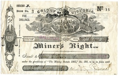 Flagstaff Hill Maritime Museum and Village
Ephemera - Miner's Right - Collins, 1888
This Miner’s Right was issued post the rush of the 1850s-60s but is testament to the ongoing interest in gold although the great rush had dwindled. Local papers continued to report on findings and hopes of success, including syndicates and explorations across the south-west district of Victoria and Otways. The Warrnambool correspondent of the “Hamilton Spectator”, 31/1/1878, p4 attest to the price of a good season of potatoes comparing “favourably with the unsteady returns of any precarious gold-bearing quartz reefs in the colony.” A James Collins (1842-1918) is listed in the Pioneers’ Register, Warrnambool, Township and Shire 1839-1900, Volume One, A.I.G.S Warrnambool Branch, 2004, p137. As are numerous other Collins pioneer families of the district. This item is significant in that it illustrates that people associated with the region were interested in taking their chances in prospecting for gold similar to many others. A lure that is still present for some today. Although the southwest region found it's source of wealth in other industries from whaling and fishing, wool and other agricultural pursuits. This is a top to bottom upright image of a Miner’s Right. It is a buff coloured document printed in black ink. It was issued in “BALLARAT” and rubber stamped twice in red ink. The issue to “James Collins”, is dated “23rd August 1889” to “22nd August 1890”. The signature of the authority could be Bennet. All handwriting is script style in black ink. Looking from the front the lefthand side has a serrated edge. The back is printed in black ink and there are no “particulars of registration”. The Miner’s Right is from “Series J, Book No. 3, ticket “No. 15”. A “Colony of Victoria” coat of arms is displayed at the top of the document. An insignia runs along the lefthand side of the license featuring coat of arms with a kangaroo and emu, then a miner’s pick and shovel, two crossed Union Jack flags sit behind a monogram “VR” with a hanging set of scales supported by a sword. "By Authority Robt. S. Brain, Government Printer.""Series J. Book No. 3 Five Shillings. No. 15. Colony of Victoria. Miner's Right"flagstaff hill, warrnambool, shipwrecked coast, flagstaff hill maritime museum, maritime museum, shipwreck coast, flagstaff hill maritime village, great ocean road, james collins, australian goldfields, miner's rights, the history of ballarat, gold rush -
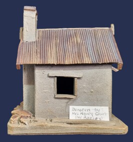 Wodonga & District Historical Society Inc
Artwork, other - Pollard's Creamery, Bonegilla Flats
... in the Bonegilla district. Pollard Family Agricultural Buildings Underneath ...George Pollard was born in Corfe, Dorsetshire England in 1824. Being dissatisfied as a clay miner, he decided to migrate to Australia. He migrated in 1851 and after a short unsuccessful time on the goldfields in Bendigo, followed by a period in Dederang and farming in Oxley, he selected land on Little River, now know as the Kiewa River in 1868. His property was know as Rosebank and George continued to live there until his death in 1915. In the early 1880s, George Pollard constructed a creamery on his property at Bonegilla Flat. The creamery stood until the late 1970s although in a state of ruin and used neaas a scratching post by the cattle which grazed in the surrounding paddock. The creamery included a chimney and fireplace. This generated warmth so that when large pans of milk were placed near the fire the cram would rise to the top and could easily be separated to produce butter for the growing family. In 1982 Fred Hillier was visiting from Queensland and offered to make the replica of the creamery featured Wodonga & District Historical Society Collection.This item is significant because it represents a creamery owned by an important family in the Bonegilla district.A small model of an old building made from clay. It includes a roof resembling corrugated iron and empty spaces for windows.Underneath Model Bonegilla Creamery 1886 By Fred Hillier 1982pollard family, agricultural buildings -
 Lakes Entrance Historical Society
Photograph - large maize crib Bruthen Victoria, Maize crib Bruthen Victoria, 1990 c
... possibly last one still remaining in district. Farming ...possibly last one still remaining in district.Black and white photograph of large maize crib Situated on eastern side of main road from Bruthen to Mossiface Victoriafarming, agriculture -
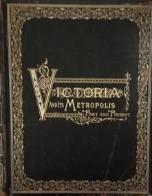 Hymettus Cottage & Garden Ballarat
Work on paper - Book, Victoria and Its Metropolis Volume One
A history of Victoria from the time of the discovery of Australia through until 1888.non-fictionA history of Victoria from the time of the discovery of Australia through until 1888.melbourne, victoria, exploration, settlement, john batman, john pascoe fawkner, pioneers, colonisation, aboriginals, discovery of gold, democracy, burke and wills, agriculture, manufacturing, literature, art, music, drama, education, science, churches, history, ballarat, eureka -
 Lakes Entrance Historical Society
Photograph, George Price Grant Metung, 1900 c
Myrtle Fish collection daughter of George Price GrantSepia toned photograph showing large Bullock team of George Price Grant of Metung moving a small building in Metung district four men visible one on right with an axe other with whips. Bare hill and a few dead trees in background showing early land improvement for agriculture Metung Victoria genealogy, settlers -
 Narre Warren and District Family History Group
Book, Ann Smith, Back to Pakenham - March 3-10, 1951
A souvenir booklet published for the 'Back to Pakenham' event held from 3 to 10 March 1951. A particularly interesting week of festivities has been arranged in connection with the "Back-to-Pakenham" celebrations, extending from March 3 to 10. The round of functions includes a picnic race meeting, Pakenham Agricultural Show, children's, old-time and amateur athletic sports carnivals, balls, community singing, the closing stages of a Queen Carnival, school and other reunions, special Church services and trips to district places of interest. A hearty welcome awaits former residents, and they are invited to write to Mr. N. N. Webster, Pakenham East, for full details of the programme. (Newspaper article published in the Kilmore Free Press on 15 February 1951.)non-fictionA souvenir booklet published for the 'Back to Pakenham' event held from 3 to 10 March 1951. A particularly interesting week of festivities has been arranged in connection with the "Back-to-Pakenham" celebrations, extending from March 3 to 10. The round of functions includes a picnic race meeting, Pakenham Agricultural Show, children's, old-time and amateur athletic sports carnivals, balls, community singing, the closing stages of a Queen Carnival, school and other reunions, special Church services and trips to district places of interest. A hearty welcome awaits former residents, and they are invited to write to Mr. N. N. Webster, Pakenham East, for full details of the programme. (Newspaper article published in the Kilmore Free Press on 15 February 1951.)pakenham (vic.), back to pakenham -
 Narre Warren and District Family History Group
Book, John Murphy, One bag in six : onion growing in Gippsland 1900-2007, 2007
The book explores the history of onion farming in South Gippsland, Victoria. It delves into the establishment of a viable onion-growing industry in the region, highlighting the challenges and successes faced by farmers over more than a century. [AI generated text]97 p.; 21 cmnon-fictionThe book explores the history of onion farming in South Gippsland, Victoria. It delves into the establishment of a viable onion-growing industry in the region, highlighting the challenges and successes faced by farmers over more than a century. [AI generated text] onion industry -- victoria -- gippsland region -- history, onions -- victoria -- gippsland region -- history, gippsland region (vic.) -- history -
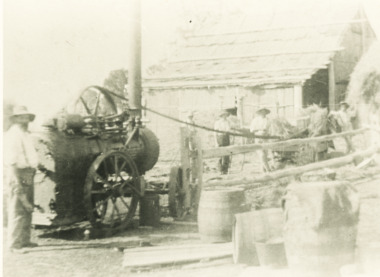
 Lakes Entrance Historical Society
Photograph - Steam Engine, Gippsland Victoria
... Contractor with steam engine often travelled to district ...Contractor with steam engine often travelled to district farms as requiredBlack and white enlarged photograph of a large steam traction engine showing container at back holding wood for boiler and smoke stack. Driver on board Gippsland Victoriaagriculture, engineering -
 Lakes Entrance Historical Society
Photograph - Hay Baling, Steam engine baler, East Gippsland, 1915 c
Shed behind workers in clad and roofed with bark sheets held in place with horizontal timbers. The contractor with steam engine travelled around the district as requested by land ownersBlack and white photograph of five workers baling hay using small steam engine to power the baler on a farm in East Gippslandagriculture, steam engine -
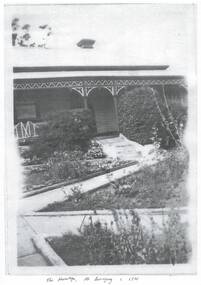 Buninyong & District Historical Society
Photograph - Black and white copies of photographs of "The Hermitage", Photographs of "The Hermitage" home of the Poynton family
... the life of the early families in the district, their agricultural ...The Poynton family arrived in Buninyong in 1896 and established a property in Warrenheip Street followed by the purchase of "The Hermitage" on the slopes Mount Buninyong for the succeeding generations to supply cream, potatoes, pigs, peas and gooseberries to the local community. Silas Poynton was appointed a Trustee of the Buninyong Methodist Church in 1914 and family life revolved around the Church and its activities for many years.This home represents the life of the early families in the district, their agricultural activities and their community links. Various views of "The Hermitage" circa 1920s and a copy of the contract for the purchase"The Hermitage" Mt. Buninyong c. 1920poynton family, "the hermitage", mount buninyong, methodist church -
 Lakes Entrance Historical Society
Photograph - Steam Engine, 1980 c
... around district as requested Machinery Agriculture Black ...Contractor with steam engine would travel from farm to farm around district as requestedBlack and white photograph of men at small steam engine used to power chaff cutting machine with four workers in charge. Bark roofed building nearby believed to be at Howlett or Bobribb property Bumberrah Victoriamachinery, agriculture -
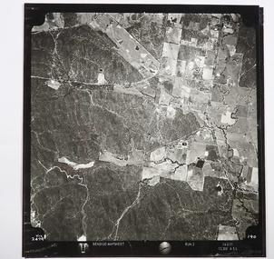 Bendigo Historical Society Inc.
Map - CAMPBELL COLLECTION: BENDIGO AND DISTRICT MAPS
Map. Two aerial photographs of Kangaroo Flat and Lockwood (part). Crusoe Reservoir bottom right corner on Crusoe Road, shows Merindah Road running between Lockwood and Crusoe Roads. Map Name : Bendigo Mapsheet Run 2. 14-2-71, 13,200 A.S.L.. Map shown with NORTH at bottom of page, VIC 2479 at corner. Map 2 continues to the west. A joined copy of both photographs is also included.map, bendigo, agricultural lands