Showing 4892 items matching "black hills"
-
 Eltham District Historical Society Inc
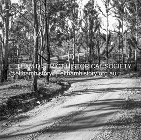
Album - Photograph, J.A. McDonald, Were Street, Montmorency, Nov. 1956
Victoria Roads construction May 1956Record of various Shire of Eltham infrastructure works undertaken during the period of 1952-1962 involving bridge and road reconstruction projects, sometimes with Eltham Shire Council Project Reference numbers quoted. It was during this period that a number of significant improvements were made to roads and new bridges constructed within the shire that remain in place as of present day (2022). In many situations, the photos provide a tangible visible record of infrastructure that existed throughout the early days of the Shire. The album was put together by or under the direction of the Shire Engineer, J.A. McDonald.infrastructure, shire of eltham, 1956-05, briar hill fibrous plaster, bridge construction, bulldozer, montmorency, road construction, were street -
 Eltham District Historical Society Inc
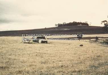
Album - Photograph, J.A. McDonald, Garden Hill, Kangaroo Ground, c. 1962
Garden Hill burnt following bush fires - most likely the 15-16 Jan 1962 fire A helicopter can be seen flying over the top of the hill Eltham Shire Council purchased this property in the early 1970s and it has now been incorpoarted within the Shire of Eltham Memorial ParkRecord of various Shire of Eltham infrastructure works undertaken during the period of 1952-1962 involving bridge and road reconstruction projects, sometimes with Eltham Shire Council Project Reference numbers quoted. It was during this period that a number of significant improvements were made to roads and new bridges constructed within the shire that remain in place as of present day (2022). In many situations, the photos provide a tangible visible record of infrastructure that existed throughout the early days of the Shire. The album was put together by or under the direction of the Shire Engineer, J.A. McDonald.1962, garden hill, kangaroo ground, shire of eltham memorial park, victorian bushfires - 1962 -
 Eltham District Historical Society Inc
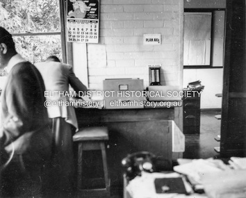
Album - Photograph, J.A. McDonald, Garden Hill, Kangaroo Ground, Feb. 1963
Most likley the interior of the Eltham Shire Offices at the corner of Artur Street and Main Road. The calendar is set on February 1963. ERngineering and Planning were also loacted in the shop fronts located next door on Main Road.Record of various Shire of Eltham infrastructure works undertaken during the period of 1952-1962 involving bridge and road reconstruction projects, sometimes with Eltham Shire Council Project Reference numbers quoted. It was during this period that a number of significant improvements were made to roads and new bridges constructed within the shire that remain in place as of present day (2022). In many situations, the photos provide a tangible visible record of infrastructure that existed throughout the early days of the Shire. The album was put together by or under the direction of the Shire Engineer, J.A. McDonald.arthur street, eltham, eltham shire office, main road, 1963-02 -
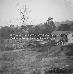
 Eltham District Historical Society Inc
Negative - Photograph, J.A. McDonald, Kangaroo Ground-Queenstown Road, Aug. 1960
Beginning of roll of film Most likely at (Kangaroo Ground-St Andrews Road) “Rymers” Corner – shifting Hawthorn hedges on Tompkins property August 1960Record of various Shire of Eltham infrastructure works undertaken during the period of 1952-1962 involving bridge and road reconstruction projects, sometimes with Eltham Shire Council Project Reference numbers quoted. It was during this period that a number of significant improvements were made to roads and new bridges constructed within the shire that remain in place as of present day (2022). In many situations, the photos provide a tangible visible record of infrastructure that existed throughout the early days of the Shire. The album was put together by or under the direction of the Shire Engineer, J.A. McDonald.infrastructure, shire of eltham, 1960-08, garden hill, kangaroo ground, kangaroo ground-queenstown road, kangaroo ground-st andrews road, rymers corner -
 Eltham District Historical Society Inc
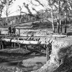
Negative - Photograph, J.A. McDonald, Clintons Road, Christmas Hills, 2 July 1962
Looking southwards Temporary bridge on RHS 2 July 1962 The bridge was destroyed by bushfires 15-16 January 1962Record of various Shire of Eltham infrastructure works undertaken during the period of 1952-1962 involving bridge and road reconstruction projects, sometimes with Eltham Shire Council Project Reference numbers quoted. It was during this period that a number of significant improvements were made to roads and new bridges constructed within the shire that remain in place as of present day (2022). In many situations, the photos provide a tangible visible record of infrastructure that existed throughout the early days of the Shire. The album was put together by or under the direction of the Shire Engineer, J.A. McDonald.1962-07-02, bridge construction, christmas hills, clintons road, infrastructure, shire of eltham, victorian bushfires - 1962, bush fires -
 Eltham District Historical Society Inc
Negative - Photograph, J.A. McDonald, Clintons Road, Christmas Hills, 2 July 1962
Burned bridge Temporary bridge on RHS 2 July 1962 The bridge was destroyed by bushfires 15-16 January 1962Record of various Shire of Eltham infrastructure works undertaken during the period of 1952-1962 involving bridge and road reconstruction projects, sometimes with Eltham Shire Council Project Reference numbers quoted. It was during this period that a number of significant improvements were made to roads and new bridges constructed within the shire that remain in place as of present day (2022). In many situations, the photos provide a tangible visible record of infrastructure that existed throughout the early days of the Shire. The album was put together by or under the direction of the Shire Engineer, J.A. McDonald.1962-07-02, bridge construction, christmas hills, clintons road, infrastructure, shire of eltham, victorian bushfires - 1962, bush fires -
 Eltham District Historical Society Inc
Negative - Photograph, J.A. McDonald, One Tree Hill Road Bridge, Christmas Hills, 2 July 1962
One Tree Hill Road Looking south 2/7/62 The bridge was destroyed by bushfires 15-16 January 1962. A temporary bridge was set up to the east sideRecord of various Shire of Eltham infrastructure works undertaken during the period of 1952-1962 involving bridge and road reconstruction projects, sometimes with Eltham Shire Council Project Reference numbers quoted. It was during this period that a number of significant improvements were made to roads and new bridges constructed within the shire that remain in place as of present day (2022). In many situations, the photos provide a tangible visible record of infrastructure that existed throughout the early days of the Shire. The album was put together by or under the direction of the Shire Engineer, J.A. McDonald.1962-07-02, bridge construction, christmas hills, infrastructure, shire of eltham, victorian bushfires - 1962, bush fires, one tree hill road, property damage -
 Eltham District Historical Society Inc
Photograph - Black and White Print, Moor-rul Viewing Platform, March 2007
Early stages - no display panels installed. OPENING OF THE VIEWING PLATFORM AT KANGAROO GROUND Nillumbik Council has advised that the viewing platform at Kangaroo Ground 27km NE of Melbourne is to be opened to the public on Wednesday, March 26th 2008 (Melway 271 , G10). The function of the platform is to provide shelter adjacent to the War Memorial Tower whilst allowing all people to enjoy the stunning panoramic views. From the platform you. can see the Dandenongs, the city of Melbourne, the You Yangs, Mount Macedon, the Kinglake Ranges and the Mt Baw-Baw Ranges where the Yarra River starts. This landscape covers all the ancestral lands of the Wurundjeri and some of the wider Kulin nation land. The platform has been given the name Moor-rut, a name which described the fertile soils of the Kangaroo Ground area in contrast to the poorer (Silurian) country of its surrounds, which the Wurundjeri knew as 'Nillumbik' or less rich country. The full 360 degree view can be seen from the adjacent Tower of Remembrance which has 53 stairs. The viewing platform however can be accessed by wheelchair. Inside the viewing platform there are eight double sided interpretive panels giving the history and information regarding this special area. The viewing platform's interpretive panels set out the Aboriginal and European history of the area and also the geology and the local flora and fauna, so that the casual visitor comes away understanding more about this significant part of Victoria. The concept of the viewing platform is part of the refurbishment project for the Kangaroo Ground War Memorial Park which has taken place since 1997 with the active approval and financial assistance of the Nillumbik Shire Council. This project has been guided by an Advisory Committee with volunteer community representatives from the local Historical Societies, the Country Fire Authority, the Returned Services League and the Wurundjeri people. Other allied groups such as the Nillumbik Reconciliation Group have been called upon for their expertise. The initial idea for the viewing platform came from Dean Stewart when he was the caretaker while living at the park. He discussed this idea with local author Mick Woiwod and Harry Gilham of Eltham District Historical Society when they were planning the refurbishment of the War Memorial Park in 1996. When the committee was formalised by the Nillumbik Council in 1997, Nicholas Pelling, representing the CFA and RSL, joined the group. Dennis Ward, local architect, then volunteered to develop the concept plan for the refurbishment of the park and later drew up the plans for the viewing platform. The Kangaroo Ground War Memorial Park and its Tower of Remembrance is located on one of the highest locations in the Yarra Valley. The Tower of Remembrance is a unique war memorial constructed from local stone standing 14 metres high. It was built in the style of a Scottish watchtower reflecting the strong Scottish influence of the first European settlers of the district from the 1840s onward. The park was opened in 1921 and the Tower of Remembrance was dedicated in 1926 recognising the local people who served in the First World War. Those who served in the Second World War were recognised by plaques dedicated in 1951 and more recently those who served in Korea, Borneo, Malaya and Vietnam by plaques unveiled in 2001. Harry Gilham, Advisory Committee Convenor - Eltham District Historical Society Newsletter N0 179 March 2008 Black and white inkjet print on paper 14 x 21 cmmoor-rul viewing platform, garden hill, kangaroo ground, memorial park -
 Eltham District Historical Society Inc
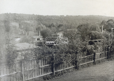
Photograph - Black and White Print, Unidentified view, possibly Eltham, c.1985
View looking over residential housing towards hills covered in trees - possibly Eltham areaBlack & White print on textured photographic paperunidentified, residential -
 Eltham District Historical Society Inc
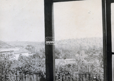
Photograph - Black and White Print, Unidentified view, possibly Eltham, c.1985
View looking over residential housing towards hills covered in trees - possibly Eltham areaBlack & White print on textured photographic paperunidentified, residential -
 Eltham District Historical Society Inc
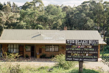
Slide - Photograph, The Black Billy Tea Room, Panton Hill, c.May 1988
... melbourne Panton Hill The Black Billy Tea Room Process Date MAY 88M ...35mm colour positive transparency (1 of 25) Mount - Kodak EktachromeProcess Date MAY 88Mpanton hill, the black billy tea room -
 Eltham District Historical Society Inc
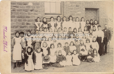
Photograph, Theodor Black, Girl Students, Eltham State School No. 209, c.1904
Photo taken at the east end of the school. 1. Head Teacher John Brown served as HT from 1889 to his death in Sept 1906. 2. 53 Girls and 42 boys - 95 - attendance figures known between 1899 and 1906. 3. Female teacher in both photohraphs is Miss Amy E Barrowclough (Oct 1900 through 1904) [150th anniversary book incorrectly identifies her as Ellen Sweeney] 4. Youth in doorway is the Monitor, Harold Gilsenan (1904) 5. Post and rail fencing along Dalton Street (seen behind John Brown) was built in the upgrade of 1903 These facts date the photographs to be c.1904-c.1905 [Harry Gilham] Ina Falkiner is top row 4th from left Gertrude Falkiner is bottom row seated 4th from left. (Identified by Gertrude's garnddaugher and Ina's great neice, Judith Vun, email 26 May 2022) John Brown died 23 Sept 1906 after a short severe illness at age 55 and is buried in Box Hill Cemetery (Evelyn Observer 28 Sep 1906 p2). The book "We did open a school in Little Eltham" incorrectly states his date of death as 16/12/1906. Title The Evelyn Observer. (1906, September 28). Evelyn Observer and Bourke East Record (Vic. : 1902 - 1917), p. 2 (MORNING.) Url http://nla.gov.au/nla.news-article61129880 Description It is with sincere regret we record the death of Mr. John Brown, State school teacher, Eltham, which sad event took place at his residence, "Pine Brae," on Sunday night last, 23rd inst. after a severe illness of some few weeks' duration. The deceased gentleman was highly respected, and always took a lively and active interest in promoting the progress and prosperity of the district, and his loss will be much felt, He was only 55 years of age, and leaves a wife and large family to mourn their loss, and much sympathy is felt for them. The remains of the deceased were interred in the Box Hill cemetery on Wednesday afternoon last. PANEL 1875-1920 Panels began to be produced around 1875, and were particularly suited, because of their larger size, for capturing family, or even larger, groups. They measured 8.5 by 6.5 inches (22 cm x 16.5 cm). - Frost, Lenore; Dating Family Photos 1850-1920; Valiant Press Pty. Ltd., Berwick, Victoria 1991marg ball collection, shillinglaw family photo album 3, class photo, eltham primary school, eltham state school no. 209, 1904, gretrude falkiner, ina falkiner, john brown, miss amy e barrowclough, state school no. 209, theodor black photographer -
 Eltham District Historical Society Inc
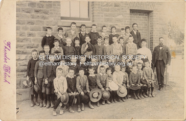
Photograph, Theodor Black, Boy students, Eltham State School No. 209, c.1904
Photo taken at the east end of the school. 1. Head Teacher John Brown served as HT from 1889 to his death in Sept 1906. 2. 53 Girls and 42 boys - 95 - attendance figures known between 1899 and 1906. 3. Female teacher in both photohraphs is Miss Amy E Barrowclough (Oct 1900 through 1904) [150th anniversary book incorrectly identifies her as Ellen Sweeney] 4. Youth in doorway is the Monitor, Harold Gilsenan (1904) 5. Post and rail fencing along Dalton Street (seen behind John Brown) was built in the upgrade of 1903 These facts date the photographs to be c.1904-c.1905 [Harry Gilham] Ina Falkiner is top row 4th from left Gertrude Falkiner is bottom row seated 4th from left. (Identified by Gertrude's garnddaugher and Ina's great neice, Judith Vun, email 26 May 2022) John Brown died 23 Sept 1906 after a short severe illness at age 55 and is buried in Box Hill Cemetery (Evelyn Observer 28 Sep 1906 p2). The book "We did open a school in Little Eltham" incorrectly states his date of death as 16/12/1906. Title The Evelyn Observer. (1906, September 28). Evelyn Observer and Bourke East Record (Vic. : 1902 - 1917), p. 2 (MORNING.) Url http://nla.gov.au/nla.news-article61129880 Description It is with sincere regret we record the death of Mr. John Brown, State school teacher, Eltham, which sad event took place at his residence, "Pine Brae," on Sunday night last, 23rd inst. after a severe illness of some few weeks' duration. The deceased gentleman was highly respected, and always took a lively and active interest in promoting the progress and prosperity of the district, and his loss will be much felt, He was only 55 years of age, and leaves a wife and large family to mourn their loss, and much sympathy is felt for them. The remains of the deceased were interred in the Box Hill cemetery on Wednesday afternoon last. PANEL 1875-1920 Panels began to be produced around 1875, and were particularly suited, because of their larger size, for capturing family, or even larger, groups. They measured 8.5 by 6.5 inches (22 cm x 16.5 cm). - Frost, Lenore; Dating Family Photos 1850-1920; Valiant Press Pty. Ltd., Berwick, Victoria 1991marg ball collection, shillinglaw family photo album 3, class photo, eltham primary school, eltham state school no. 209, 1904, harold gilsenan, john brown, miss amy e barrowclough, state school no. 209, theodor black photographer -
 Eltham District Historical Society Inc
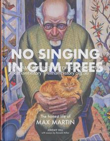
Book, Jeremy Hill et al, No singing in gum trees : the honest life of Max Martin / Jeremy Hill ; with essays by Ronald Miller, 2023
Summary "A young man from the working-class suburb of Fitzroy was on the cusp of a brilliant career and was the talk of the Academy's salons. Far from his humble origins, he now stood shoulder to shoulder with the leading figures of London's art world. Max Martin was an enigmatic achiever who stood briefly on the mountaintop but died in obscurity. It was over thirty years after his death before a painting of his was acquired by a public collection. The National Gallery of Victoria, Newcastle City Gallery in New South Wales and the art collection of the State Library of Victoria now all hold his work. What made him turn his back on painting at the height of critical acclaim? How close was he to a career in mainstream ballet and what drove him to march for disarmament in his later years?"--Booktopia.artists, eltham, max martin, biography -
 Eltham District Historical Society Inc
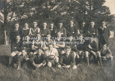
Photograph, Diamond Creek Football Club, c.1906
Thomas Edmund Fielding (1874-1957) was a significant member of the Diamond Creek Footbal Club during the early 1900s. Son of Robert Fielding (1820-1891) and Jemima Whatmough (1840-1926) and grandson of Plenty River pioneers Robert Whatmough (1815-1887) and Mary Hill (1813-1881)diamond creek football club, thomas edmund fielding, tom fielding collection, sports -
 Eltham District Historical Society Inc
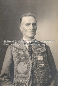
Photograph, The Allan Studio, Thomas Edmund Fielding in his IOOF uniform, c.1901
Independent Order of Odd Fellows (IOOF) https://en.wikipedia.org/wiki/Independent_Order_of_Odd_Fellows Thomas Edmund Fielding (1874-1957) was a significant member of the Diamond Creek Footbal Club during the early 1900s. Son of Robert Fielding (1820-1891) and Jemima Whatmough (1840-1926) and grandson of Plenty River pioneers Robert Whatmough (1815-1887) and Mary Hill (1813-1881) Photo: The Allan Studio, 318 Smith Street, Collingwood Mark Joshua Allan, Photographer operated fropm 318 Smith Street Collingwood from 1887 to 1901thomas edmund fielding, tom fielding collection, independent order of odd fellows (ioof), m.j. allan photographers 318 smith st collingwood -
 Eltham District Historical Society Inc
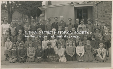
Photograph - Digital Copy, George Murray, Eltham State School, Grade 2, 1958
Back Row (L-R): Russell Smart, John Mead, Peter Norman, Kim Hunter, Richard Lynch, Stephen Short, Gilbert McGloughlin, Don Muir, Jeff Steele, Geoffrey Thorpe, Ian Murray, Marcus Skipper, Ray ( ? ), Robert Spencer Third Row (L-R): Bruce Martin, Neville Myers, Nelson (Smart?), George Sutherland, Robert Dowdell, David Campbell, Ken Dickerson, Kit Hill, Wayne Brodford, Martin Fowler, Michael Kilpatrick, Colin Graham, Ken Brown, David Boss, Greg Lewis Second Row (L-R): Bora Meredith, Heather Dyke, Linda Morris, Janne Miles, Biddy Quinlan, Cheryl Croft, Terry Croft, Margaret Box, Shelley Barker, Wendy Bradley, Sandra Black, Lynette Pitcher Front Row (L-R): Sally Lewis, Faye Harris, Elizabeth Jolley, Wendy Rainsbury, Helen Corrie, Bronwen Cavistock, June Skippington, Gloria Oldfield, Anna Jacka, Ruth GangellNames written on reverse and photographer's stamp1958, anna jacka, biddy quinlan, bora meredith, bronwen cavistock, bruce martin, cheryl croft, class photo, colin graham, david boss, david campbell, don muir, elizabeth jolley, eltham state school no. 209, faye harris, faye walker (nee harris) collection, geoffrey thorpe, george sutherland, gilbert mcgloughlin, gloria oldfield, grade 2, greg lewis, heather dyke, helen corrie, ian murray, janne miles, jeff steele, john mead, june skippington, ken brown, ken dickerson, kim hunter, kit hill, linda morris, lynette pitcher, marcus skipper, margaret box, martin fowler, michael kilpatrick, nelson smart, neville myers, peter norman, richard lynch, robert dowdell, robert spencer, russell smart, ruth gangell, sally lewis, sandra black, shelley barker, stephen short, terry croft, wayne brodford, wendy bradley, wendy rainsbury -
 Eltham District Historical Society Inc
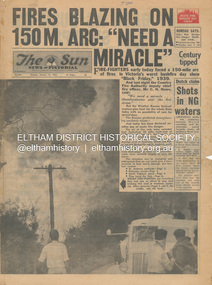
Newspaper - Newspaper articles, Sun News-Pictorial, Fires Blazing on 150M. Arc: "Need a Miracle", The Sun News-Pictorial, Tuesday, January 16, p1, 1962
Various news articles pertaining to the January 1962 Victorian bushfires in the Dandenong and Healesville districts which by second day had spread on to a 150 mile front fromDaylesford and Kinglake through to the Dandenongs. Specific Eltham Shire districts mentioned include Ninka Road, St. Andrews, Kinglake, Hurstbridge on page 2 • Fires Blazing on 150M. Arc: "Need a Miracle", p1 (Illust.) – Victoria’s worst bushfire day since “Black Friday,” 1939 • Night dash as bushfire sweeps by, p2 (Illust.) • Kalorama Saved: Fire 100 Ft. Away, p2 • Stay away, says police chief, p2 • The Tragedy of the Fires, p3 (Illust.) • Good save by firemen, p4 (Illust.) • S.E.C. Firemen Saved N. Yallourn, p4 • Cherry river of flame, p4 • From the fire front: Fire-fighters are bitten by snakes, p4 • They faced the fury, p6 (Illust.) • The ’39 Blaze, p6 • They fought and failed, p6 • Hills Aflame: 2nd Day, pp16-17 (Illust.) • Respite at Olinda HQ, p16 (Illust.) • Here is Ruin, p17 (Illust.) • This fireman had to work among piled up furniture … p32 (Illust.) tom fielding collection, victorian bushfires - 1962, victorian bushfires – 1962, black friday, victorian bushfires – 1939, c.h. howe, daylesford, country fire authority, dandenongs, yallourn, central gippsland, montrose, olinda, kalorama, healesville, st. andrews, hurstbridge, ninka road, kinglake, yarra glen, a.l. mccutcheon, st. andrews postmaster, eltham shire secretary, max watson, police commissioner porter, observatory road, mt. dandenong, whittlesea, one tree hill, sassafras, the basin, steel’s creek, ruby ryan, the basin progress hall, yaallourn, yallourn north, stet electricity commission (s.e.c.), hernes oak, mcdonalds track, florence milkins, lieutenant-colonel k. leggett, bonza view road, ringwood police station, michael o’connor, volunteers, fire damage - buildings -
 Eltham District Historical Society Inc
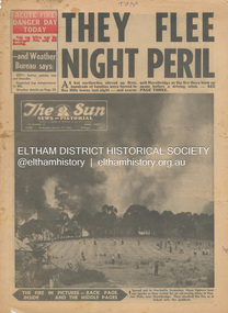
Newspaper - Newspaper articles, Sun News-Pictorial, They Flee Night Peril, The Sun News-Pictorial, Wednesday, January 17, p1, 1962
Various news articles pertaining to the January 1962 Victorian bushfires in the Dandenong and Healesville districts which by the third day had encompassed large areas of the State. Specific Eltham Shire districts mentioned include Panton Hill and Hurstbridge on page 1, Warrandyte on page 2, 3, 4 and 5, Hurstbridge, Smith’s Gully, Kinglake on page 3 and 4, Strathewen, Kangaroo Ground, Panton Hill, St. Andrews, Smith’s Gully on page 4 and Pound Bend, Smith’s Gully and Warrandyte on pages 20-21 • They Flee Night Peril, p1 (Illust.) • Their grim picnic; A flash fire strikes, p2 (Illust.) • Night of terror as towns quitted, p3 • Fought till he dropped, p3 (Illust.) • Rain in fire area, p3 • Wye River town goes, p3 • Black Friday Hero Dies In Fire; with wife, grandsons, p4 • Surrounded!, p4 (Illust.) • Main street houses ablaze, p4 • Hurstbridge is evacuated, p4 • Scores jump in river at Warrandyte, p5 • Hills people leave homes, p5 • “Fire” cry at Parlt., p5 • Blind – he’s safe now, p5 (Illust.) • Police Chief Runs Battle, p7 • From Fire Front: Hospital treats 34, p7 • Firms send help, p7 • Tragedy and Ruin: Third Day; Ferntree Gully; Warrandyte; Pound Bend; Smiths Gully; Escape for 18, pp20-21 (Illust.) • Church was a haven for the hurt, weary, p39 (Illust.) • A home is lost, p40 (Illust.) tom fielding collection, victorian bushfires - 1962, victorian bushfires – 1962, panton hill, hurstbridge, five ways crossroads, warrandyte south, dandenongs, upwey, mt. evelyn, monbulk, olinda, sassafras, st. andrews, warrandyte, christmas hills, yarra river, mitcham, whitehorse roiad, donvale, park orchards, metropolitan fire chief, w.t. aldridge, loughnan’s hill, ringwood, woori yallock, leslie ockwell, linda ockwell, kalorama, healesville, daylesford, fire damage – buildings, wye river, portland, eganstown, ballarat, sherbrooke park forest, forest commission headquarters, kallista, r.t. seaton, montrose, yallourn, central gippsland, smith’s creek, black friday, geoffrey ockwell, ronald ockwell, preston town hall, e.j. tenner, strathewen, kangaroo ground, eric farnsworth, adele farnsworth, robin farnsworth, roy cleland, ann cleland, belgrave, sassfras, kaloramalice commissioner porter, mansfield, box hill hospital, pound bend, ferntree gully, ferntree gully state school, w. carew, ann quinton -
 Glen Eira Historical Society
Photograph - Nithsdale
This file contains 2 items (4 images) of this property: One reproduction of photograph of Nithsdale, date unknown in black and white. Two photographs of tower (different angles of front) at Nithsdale, date unknown in black and white plus one photocopied photo of tower. All three are copies of photographs in 'Historical Caulfield to 1972' compiled by Mrs Jenny O'Donnell, taken between 1966-1972 and held by the Glen Eira Historical Society (p102).nithsdale', architectural features, towers, caulfield north, kambrook road, glen eira road, 'five way hill' -
 Glen Eira Historical Society
Document - Elizabeth Street, 44, Elsternwick
A two page copy of a Caulfield Conservation Study by Andrew Ward, dated 09/1994, on Clifton at 44 Elizabeth Street, Elsternwick. The study includes a brief history of house occupancy, an architectural description, a statement of significance and a black and white photograph (100mm x 154mm) of the exterior of the house. The file also includes an undated and unattributed black and white photograph (90mm x 89mm) of the exterior of Clifton at 44 Elizabeth Street, Elsternwick.elizabeth street, elsternwick, clifton, clifton hill, bent street, davis street, federation style, architectural styles, architectural features, ring charles, bent thomas sir, rippon lea estate, house names, jones percy john, builders, belle vue, edwardian style, ward andrew, st georges road, english domestic revival, elsternwick urban conservation area -
Glen Eira Historical Society
Document - Glen Huntly Fire Station
This folder contains 3 copies of photographs plus notes about the Glen Huntly Fire Station: 1/A print of a small black and white photograph (95mm x 127mm) of the exterior of Glen Huntly Fire Station accompanied by typed notes sourced 13/03/2007 from the Melbourne Fire Brigade Museum. The notes indicate that the fire engine shown parked out the front was in service 1919 to circa 1924: Car 55 Rego 8499 Hose Carriage Engine No. 3178 Napier. 2/An A4 sepia copy of the same photograph (210mm x 291mm) with street advertising of one of the shops clearly visible: 'DRAPERY EMPORIUM. UNDERCLOTHING BABY LINEN; HOSIERY HABERDASHERY MILLINERY'. The electric tram at the terminus on Grange Road is also seen in the photograph. Noted on the reverse of the photo: 'Glen Huntly Road and Grange Road' in pencil. 3/A photocopy of a black and white photograph (154mm x 200mm) of Fire Engine with No. 13197 outside the Glen Huntly Fire Station. Two firefighters are seated in the carriage and three others stand on the running board. It is noted 'D DISTRICT' at the top and 'No. 29 STATION GLENHUNTLY' on the bottom.glenhuntly, glen huntly fire station, glen huntly road, glenhuntly road, grange road, eastern hill fire station, electric trams, metropolitan fire brigade board, fire stations, fire brigades, fire engines, firefighters, firefighting equipment, hose carriage engine no 3178 napier, glen huntly, melbourne fire brigade museum, russell david -
 Eltham District Historical Society Inc
Photograph, ELTHAM ARBOR DAY 1973 - Alistair Knox with school children of the Shire of Eltham, Vic, planting native trees in the Town Park, 10 October 1973, 1973-10-10
... town park panton hill primary school Black and white photograph ...ELTHAM - ARBOR DAY, 10 Oct 1973. School children of the Shire of Eltham planting trees (previously planned to take place during the visit of Sir Rohan Delacombe to the Shire on 19th September, 1973 but cancelled that day due to inclement weather). REF: 783 SOURCE: Shire of Eltham (Eltham District Historical Society) Eltham Town Park would later be renamed Alistair Knox ParkBlack and white photographeltham, arbor day, alistair knox, alistair knox park, eltham town park, panton hill primary school -
 Eltham District Historical Society Inc
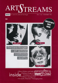
Journal, Peter Doughtery, ArtStreams: News in arts and cultural heritage; Vol. 1, No. 1, November 1996, 1996
Vol. 1, No. 1 November 1996 CONTENTS REFORMIST?: Barbara Kruger comes to the Museum of Modern Art at Heide 3 FESTIVALS Nillumbik festival celebrates our lifestyle in food, wine, music and art 5 WRITERS WEEK Barry Dickens and Judy Jacques on Ruckers Hill present the "word" in all its possibilities 8 EMERGING ARTISTS Nillumbik presents a new wave of visual artists 11 SHORT STORY Extract from a novel in progress by Jon Weaving 12 POETRY Tribute to Myra Skipper 16 HERITAGE TRAIL Youth of Eltham research local history 1 8 SCULPTURE Akira Takizawa's search for harmony 22 WRITER'S JOURNEY A writer overcomes a nightmare 24 SCIENCE AND ART Pamela Conder analyses nature 26 ARTS BALL Jazz greats come to town 27 HISTORY IN PRINTS Australia's forgotten war artist 28 "Peter Dougherty has been involved in the local art scene for many years. As publisher and editor of the arts magazine Artstreams, his comments on the various branches of the arts are widely respected. His "The Arts" column in the Diamond Valley Leader presents a brief summary for a much wider cross section of the local community. Peter also operates his own gallery and the Artstreams Cafe at the St Andrews market. Peter has a wealth of knowledge about present day and historical aspects of local art and artists." - Eltham District Historical Society Newsletter No. 161, March 2005Colour front and back cover with feature articles and literary pieces with photographs and advertisements printed in black and white. 36 pages, 30 cm. Vol. 1, no. 1 (Nov. 1996) - Vol. 10, no. 5 (summer ed. 2005/06) 1996, adam simmons, akira takizawa, alison cassidy, alistair knox park, allwood house, alvaro castagnet, angels of soul, anita hustas, anna kelly, anne curry, arts ball, avenue of honour, barbara kruger, barry dickens, batacuda, belli, belly dance and drumming group, betty rowland, bike paths, bits & pieces, blair fraser, blue tongue, bridge street, bulleen art & garden centre, bulleen nursery, bux, caffe poco, cal martin, carla cordeiro, cate bailey, charles morris, charlie dowley, chris hooke, chris kandis, chute street, circus in a suitcase, crucial kick, deirdre o'reilly, diamond creek, diamond valley big band, edna kenny, ellis cottage, eltham arts council, eltham cemetery, eltham courthouse, eltham festival, eltham high school stage and jazz band, eltham high school, eltham library, eltham people's choir, eltham symphonica band, eltham war memorial building, eltham wiregrass gallery, eucalypso, fay alexander jenkins, fiona furphy, firefly, food for all seasons, friends of the earth forest action fund, gavan gray, gene strode, geoff braithwaite, geoff kluke, george kirov, gil askey, golden cascades, graeme barker and the cats, greg o'leary, harry gilham, helen o'grady children's drama academy, heritage trail, hurstbridge goldworks gallery, italian women's choir, jackie gaudion, jackie stojznova, jacqueline gawler, janine james, jarrold cottage, jay atwill, jazz band ball, jerry hughes, jock ryan, john rasmussen, jon weaving, joseph zbukvic, joy ness, judy jacques, judy racz, jules burns, june cugola, kate jones, kavisha mazzella, kevin spearey, les gyori, lisa walker, lothlorian, louise jade, magwal, margie allan, margie lou dyer, margo barrett, mary burns, masquerade ball, melody james and friends, mermaid in the well, michael eames, michael murray, michele lonsdale, monique di mattina, montsalvat, myra skipper, nell frysteen, nerida kirov, nicole o'connor, nillumbik emerging artists exhibition, nillumbik festival, nola spence, ona henderson, opportunity shop, our lady of help christians church, pamela conder, parafinallen, patrick mccauley, peter burns, peter dougherty, pond, road, robbie greig, roger shuttleworth, ron hanson, rory cole, ross hannaford, ross needham, ruckers hill, sanctuary, scott griffiths, shep huntly, shillinglaw cottage, shire of nillumbik, shoestring, sigmund jorgensen, silvio apponyi, spindrift, st margarets anglican church, stebbing cottage, steve sedergreen, susan street, sweeney, syd tunn, tennis-courts, terry cole, the great gizmo, the picture, theo scharf, thermal skunkrust, untitled scraper board, victorian artists supplies, war artist, warrandyte, westgarth writers' week, wingrove cottage, wolfgangs palace theatre troupe, women's circus, yarra plenty rock gospel choir, you did alright kid, art streams -
 Eltham District Historical Society Inc
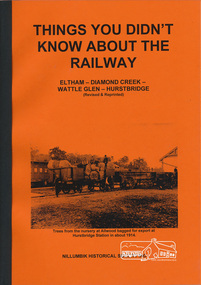
Book, Things You Didn't Know about the Railway: Eltham, Diamond Creek, Wattle Glen, Hurstbridge, 2017
Update of 1st editon by Jock Ryan published in March 2003. 2nd edition (Revised) Nillumbik Historical Society December 2017 Brief history of the agitation and eventual extension and opening of the Hurstbridge Railway line from Eltham to Diamond Creek, Wattle Glen to Hurstbridge, which was opened in June 1912. Includes details of events thereafter including Wattle Day and Railway accidents. Profusely illustrated with black and white photographs from the collection of the Nillumbik Historical Society (Diamond Creek). Agitation for a railway extension began in 1888 when a meeting was held at Arthurs Creek to press for the construction of a railway line from Heidelberg to Kinglake. The Chairman Mr Charles Draper said this was necessary because this was the best fruit growing district in Victoria. Mr Cameron M.P. pointed out that whatever route the line took it would have to follow the Diamond Valley from Eltham. At the same time another meeting was pressing for the line to be extended to Queenstown (St Andrews). However when detailed surveys were made it was discovered that the only possible route was to Hurstbridge because of the hills. In 1912 the railway was opened terminating at Hurstbridge. Bound with orange covers. Text with black and white illustrations. 30 pages.hurstbridge railway line,diamond creek,wattle glen,hurstbridge, nillumbik historical society -
 Eltham District Historical Society Inc
Journal, Peter Doughtery, ArtStreams: News in arts and cultural heritage; Vol. 3, No. 2, Apr-May 1998, 1998
Vol. 3, No. 2, Apr-May 1998 CONTENTS TOP CATS FOR '97 Emerging talent from our local schools 3 BOOK REVIEW A Small Unsigned Painting 6 LAND SHAPES Eltham artist Nel ten Wolde captures Australian images 7 REVIVING RAVENSWOOD Grand old Ivanhoe mansion restored to its former glory 9 ART IN A VEGE SHOP Murals brighten an organic greengrocer's shop 12 ADDRESSING SOCIAL CONCERNS Literary festival brings critical writers together 14 PHOTOGRAPHY Local student shows her talent 16 WOUNDEDNESS AND HEALING Australian artist in London exhibits in Eltham 18 CD REVIEW 22 SHORT STORY 23 BOOK REVIEW 25 MURALS a charming sense of community 27 EXHIBITION AT HEIDE 28 EVENT - ABORIGINAL CELEBRATION 29 ART OF PRINTMAKERS 30 ART SERVICES & TEACHING 32 "Peter Dougherty has been involved in the local art scene for many years. As publisher and editor of the arts magazine Artstreams, his comments on the various branches of the arts are widely respected. His "The Arts" column in the Diamond Valley Leader presents a brief summary for a much wider cross section of the local community. Peter also operates his own gallery and the Artstreams Cafe at the St Andrews market. Peter has a wealth of knowledge about present day and historical aspects of local art and artists." - Eltham District Historical Society Newsletter No. 161, March 2005Colour front and back cover with feature articles and literary pieces with photographs and advertisements printed in black and white. 36 pages, 30 cm. Vol. 1, no. 1 (Nov. 1996) - Vol. 10, no. 5 (summer ed. 2005/06) art streams, faces coffee place, jessie glavin, katie williams, kelly almond, michelle ceravolo, mariella mckinlay, rochelle carr, manningham gallery, stephen sheding, dynamic vegies, nel ten wolde, pool & spa care centre, bi-wize quality paints, llobex image wizards, east ivanhoe gallery, ravenswood, marguerite marshall, theresa martin, soni stecker, virginia trioli, robert dessaix, lauren williams, robert manne, chris jurewicz, moira rayner, marela mckinley, wendy donald, anne redmond, wingrove cottage community clinic, were street cafe, rob vines, ashley cross, serge de leucio, michael conolan, daniel chable, pietro ristorante grossi, lucinda mcknight, litfest 98, morag fraser, michele lonsdale, wintyre recital gallery, murals, port jackson press australia, epping secondary college, bulleen art & garden centre, christmas hills, museum of modern art at heide, nillumbik gayip, mye woonbah dancers, intaglio, violeta capovska, christina cordero, elizabeth dobrilla, belinda fox, david frazer, melinda schawel, amanda woodford, pandora journal, ward sagar, wholefood delights, dymocks booksellers -
 Eltham District Historical Society Inc
Journal, Peter Doughtery, ArtStreams: Arts & Culture in Banyule, Darebin, Manningham, Nillumbik & Whittlesea; Vol. 4, No. 3, May-Jun 1999, 1999
Vol. 4, No. 3, May-Jun 1999 CONTENTS HEIDELBERG SCHOOL REVISITED Artist's Trail extended 5 FROM JACKEROO TO ARTIST Geoffrey Dance interviewed 8 VCE TOPCATS 10 'ARTIN ABOUT 13 FERGUSON'S PADDOCK, HOME TO CHALLENGING NEW SCULPTURE 15 LA MAMA & THE COMEDY FESTIVAL 17 THE POETRY OF HISTORY The Hanging of Jean Lee 18 MUSEUM OF MODERN ART exhibitions and future plans 34 SHORT STORY High Voltage 22 DINING OUT WITH SIGMUND JORGENSEN 24 CD REVIEWS 26 BOOK REVIEWS 30 CAFE & RESTAURANT LISTINGS 32,33 "Peter Dougherty has been involved in the local art scene for many years. As publisher and editor of the arts magazine Artstreams, his comments on the various branches of the arts are widely respected. His "The Arts" column in the Diamond Valley Leader presents a brief summary for a much wider cross section of the local community. Peter also operates his own gallery and the Artstreams Cafe at the St Andrews market. Peter has a wealth of knowledge about present day and historical aspects of local art and artists." - Eltham District Historical Society Newsletter No. 161, March 2005Colour front and back cover with feature articles and literary pieces with photographs and advertisements printed in black and white. 36 pages, 30 cm. Vol. 1, no. 1 (Nov. 1996) - Vol. 10, no. 5 (summer ed. 2005/06) art streams, arthur boyd, know & grow, heidelberg artists' trail, carlucci's, geoffrey dance, vce art, kasimir burgess, clare james, andrew kelly, jason harris, nichaud fitzgibbon, noella clohesy, willy wonka's ice cream gourmet food, natalie troubnicova, ellen mileo, fergusons paddock, cathy smith, la piazza restaurant bar & cafe, la mama theatre, comedy festival, anne delaney, jordie albiston, dymocks booksellers, dynamic vegies, alison lonsdale, montsalvat, sigmund jorgensen, jacques reymond's restaurant, yarra valley country club, leslie avril, caitlin ogden, geoff achison, neil adam, judy turner, wild hill dog, louis mcmanus, adams of north riding, lovegroves of cottles bridge, artspeak studio gallery, peter sculthorpe, elizabeth scarlett, carmel bird, michelle lonsdale, museum of modern art at heide, st andrews hotel, volumes -
 Eltham District Historical Society Inc
Journal, Peter Doughtery, ArtStreams: Arts & Culture in Banyule, Darebin, Manningham, Nillumbik & Whittlesea; Vol. 4, No. 4, Jul-Aug 1999, 1999
Vol. 4, No. 4, Jul-Aug 1999 CONTENTS FOLLOWING THE SIGNS Master craftsmen of Melbourne 3 MAGNIFICENT OBSESSIONS Why we are artists 6 THE WILLIAM BLAKE EXHIBITION Closing a chapter at NGV 9 IAN McBRIDE REVIEWS Peter Porter 12 MAN OF BOOKS Anthony Marshall 13 THE INNER VIEW The book & exhibition at Arts Project Australia 16 SHORT STORY "The Angel's Paramour" 19 THE MELBOURNE BIENNALE Signs of Life 22 MONO FEAST Monologues at the Universal 23 COLLIDING RYTHYMS Blue House meets Lisa Young 25 POETRY 26 CD REVIEWS 8, 27 ARTIN' ABOUT 28 WINING & DINING 30 ART SERVICES AND TEACHING 32 "Peter Dougherty has been involved in the local art scene for many years. As publisher and editor of the arts magazine Artstreams, his comments on the various branches of the arts are widely respected. His "The Arts" column in the Diamond Valley Leader presents a brief summary for a much wider cross section of the local community. Peter also operates his own gallery and the Artstreams Cafe at the St Andrews market. Peter has a wealth of knowledge about present day and historical aspects of local art and artists." - Eltham District Historical Society Newsletter No. 161, March 2005Colour front and back cover with feature articles and literary pieces with photographs and advertisements printed in black and white. 36 pages, 30 cm. Vol. 1, no. 1 (Nov. 1996) - Vol. 10, no. 5 (summer ed. 2005/06) art streams, gordon ford, know & grow, dymocks booksellers, pam dougherty, sign writing, terry pepperell, bruce jackson, carlucci's, ona henderson, syd tunn, carl vine, elizabeth scarlett, william blake, national gallery of victoria, peter porter, willy wonka's ice cream gourmet food, katrina kincade, anthony marshall, plenty views golf park, lovegroves of cottles bridge, adams of north riding, adams of north riding, arts project australia, dorothy berry, julian martin, chris mason, john gollings, john hardcastle, montsalvat, mon feast, evelyn krape, artspeak studio gallery, karen throssell, nillumbik art award, andy cowan, wild dog hill, kerri simpson, valonga khosa, magenta, chirs wilson, veronica holland, st andrews gallery, winter in banyule, volumes -
 Eltham District Historical Society Inc
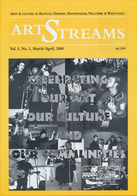
Journal, Peter Doughtery, ArtStreams: Arts & Culture in Banyule, Darebin, Manningham, Nillumbik and Whittlesea; Vol. 5, No. 1, Mar-Apr 2000, 2000
Vol. 5, No. 1, Mar-Apr 2000 CONTENTS ON THE ROAD The Car at Heide 3 ON TOP OF THE WORLD Dandenong Ranges Folk Festival 5 INTERVIEW Felicity Gordon 7 SOUNDS OF HARMONY Gyuto Monks in Eltham 10 BANYULE FESTIVAL 13 WERE ST HILL CLIMB 15 BOROONDARA WRITERS' FESTIVAL 16 WARRANDYTE VILLAGE FESTIVAL 18 DIAMOND CREEK TOWN FAIR 19 TEMPLESTOWE VILLAGE FESTIVAL 20 RECIPES From leading Chefs 21 CAIRO TO CRACOW Middle Eastern Music at Montsalvat 22 POETRY 23 FESTIVAL OF KITES 24 BOOK REVIEW By Michele Lonsdale 25 CD REVIEWS 27 ARTIN ABOUT 28 WINING & DINING 30 ARTISTS SERVICES 32 "Peter Dougherty has been involved in the local art scene for many years. As publisher and editor of the arts magazine Artstreams, his comments on the various branches of the arts are widely respected. His "The Arts" column in the Diamond Valley Leader presents a brief summary for a much wider cross section of the local community. Peter also operates his own gallery and the Artstreams Cafe at the St Andrews market. Peter has a wealth of knowledge about present day and historical aspects of local art and artists." - Eltham District Historical Society Newsletter No. 161, March 2005Colour front and back cover with feature articles and literary pieces with photographs and advertisements printed in black and white. 36 pages, 30 cm. Vol. 1, no. 1 (Nov. 1996) - Vol. 10, no. 5 (summer ed. 2005/06) art streams, carly young, plenty views golf park, dynamic vegies, dandenong ranges folk festival, felicity gordon, sounds of global harmony, banyule festival, rosanna fire station community house, bulleen art & garden centre, were street cafe, were street hill climb, bahnhof cafe, walkers wheels, peter glass, eltham wiregrass gallery, boroondara writers festival, warrandyte festival, diamond creek town fair, templestowe village festival, willy wonkas ice cream, gourmet food, ciaro to cracow, fleur de feliss florist, mia mia gallery, festival of kites, bi-wize quality paints, kinglake gallery, andy cowan, wild dog hill studio, montsalvalt, ian collard, geoff achison, bridget allen, thompsons pharmacy, volumes -
 Eltham District Historical Society Inc
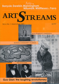
Journal, Peter Doughtery, ArtStreams: Arts in Banyule, Darebin, Manningham, Nillumbik, Whittlesea & Yarra; Vol. 6, No. 1, Mar-Apr 2001, 2001
Vol. 6, No. 1, Mar-Apr 2001 CONTENTS Vika & Linda Between Family and Fame 3 Eltham History in Ceramics A school Community cooperation 6 Exposing the beauty of clay International Pottery Market in Warrandyte 8 Were Street Hill Climb Banyule's Boutique Festival 11 Between Swirl and Solid Jenny Rodgerson's Meditations on lndeterminacy 12 Guo Gian and Anthony Pryor at HeideMOMA A laughing pointer and a craftsman sculptor 14 Dandenong Ranges Folk Festival The Hills Were Alive 16 Book Review Penelope Hobhouse's Flower & Garden Design 18 Theatre Review Kathy Oliver visits La Mama 19 Australian Classical Music Elizabeth Scarlett 20 New faces The Arts Administration Shuffle 22 Bolin Bolin Billabong Cultural Precinct and Walking Trail 24 CD Reviews 26 Artin About 28 Wining & Dining 30 Art Services and Teaching 32 "Peter Dougherty has been involved in the local art scene for many years. As publisher and editor of the arts magazine Artstreams, his comments on the various branches of the arts are widely respected. His "The Arts" column in the Diamond Valley Leader presents a brief summary for a much wider cross section of the local community. Peter also operates his own gallery and the Artstreams Cafe at the St Andrews market. Peter has a wealth of knowledge about present day and historical aspects of local art and artists." - Eltham District Historical Society Newsletter No. 161, March 2005Colour front and back cover with feature articles and literary pieces with photographs and advertisements printed in black and white. 36 pages, 30 cm. Vol. 1, no. 1 (Nov. 1996) - Vol. 10, no. 5 (summer ed. 2005/06) art streams, banyule festival, vika and linda, willy wonka's ice cream gourmet food, eltham high school, arts science courtyard project, plenty views golf park, jane annois, nillumbik festival of the arts, bahnhof cafe, dynamic vegies, were st food store, were street hill climb, walkers wheels, jenny rodgerson, claire renkin, heide museum of modern art, guo jian, anthony pryor, dandenong ranges folk festival, kinglake galley, bulleen art & garden, montsalvat, rachel hanrahan, fran silvester, helen baker, katrina phillips-rank, old bakery cottage, bolin bolin billabong, eltham wiregrass gallery, thompsons pharmacy, st andrews market, heide museum of modern art