Showing 909 items matching "eltham east"
-
 Montmorency–Eltham RSL Sub Branch
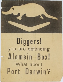
Pamphlet - German Propaganda Leaflet El Alamein 1942, El Alamein German Propaganda Leaflet, World War Two 1942
Leaflet dropped from German/Italian aircraft on to Australian troops defending El Alamein during 1942. These propagander leaflets were designed to lower moral of defending troops, but were generally unsuccessful. This item relates to the history of the defence of El Alamein by Australian Forces in the Middle East 1942, and the bombing of Darwin by the Japanese in 1942.Printed paper, colour black white. top of pamphlet depicts a stylized platypus and boomerang - the 9th Division's Formation Sign, with text below. Printed on pamphlet "Diggers! / you are defending / Alamein Box! / What about / Port Darwin?" world war two, el alamein, propaganda, leaflet, plane drop, port darwin, diggers, platypus, boomerang -
 Montmorency–Eltham RSL Sub Branch
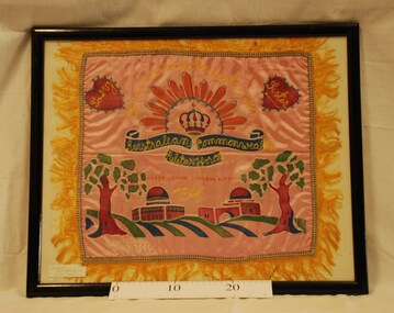
Craft - Framed Embroided Centrepiece, WW2 Embroidered Silk Centrepiece Souvenir, Estimated date 1941
World War Two souvenir.This framed World War Two souvenir is an embroidered silk centrepiece. On a pink background, fringed in yellow, appear two red hearts in the top left and right corners. Inside the hearts, in yellow, are the words - 'To My' - 'Sister'. Underneath, the words 'Souvenir of Palestine' are embroidered in a yellow arc, a rising sun in orange, a red, green and blue crown, and - 'Australian' - 'Commonwealth' - 'Military Forces' - in yellow and blue. At the botton there are two trees either side of two domed buildings, all in red, green and blue. 'Australian Commonwealth Military Forces'. '1941'. 'To my Sister'. 'Souvenir of Palestine'.embroidery, middle east, australia, military, commonwealth, 1941, souvenir, second world war, palestine -
 Montmorency–Eltham RSL Sub Branch
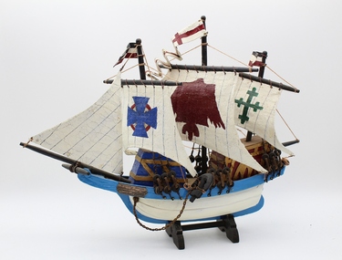
Craft - Model Ship Made By Australian POWs, WW2 Ship made by Australian POWs, Estimated date 1945
During World War II, over 22,000 Australian became prisoners of war to the Japanese. Most of them were captured at the fall of Singapore in February 1942 and were forced to march to Changi (the major Prisoner of War camp). Later on, the soldiers would be dispersed throughout South East Asia. Upon their return to Australia, very few of them told talked about their experience as prisoners (they often felt ashamed). It took almost 30 years before testimonies, books and documentaries would be published. This ship model was built by Australian prisoners of wars.Model of a Spanish or Portugese 18th Century sailing ship, manufactured from timber, fabric and string. Natural timber colours as well as white, blue, red, green and gold.'To Auntie Helen, many thanks for everything from P.O.W.s Singaporesingapore, war, ships, second world war, model, 1945, models, p o w s, prisoners -
 Montmorency–Eltham RSL Sub Branch
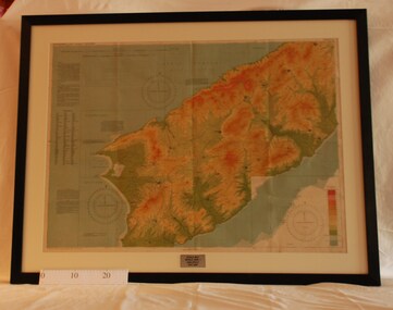
Map - Framed 1915 map of Sulva Bay, Gallipoli, 1915 Map of Silva Bay, Gallipoli, 1915
This map was used in the Dardenelles Campaign 1915-1916.Framed map showing the Sulva Bay area of the Gallipoli battlefield in 1915.world war one, middle east, gallipoli, 1915, map, dardenelles, sulva bay, survey department, battlefields, egypt cairo -
 Montmorency–Eltham RSL Sub Branch
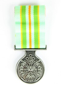
Medal - Military Kid Medallion, Foxhole Medals, After 2004
This medal was presented to the children of Victorian Wing - Warrant Officer and Non Commissioned Officers Academy Soldier who have served on operational deployments. As these young children endured an operational deployment of a parent who spent many months away from home in a foreign country representing the Australian Army. Following operations include Bougainville, East Timor, Indian Ocean, Solomon Islands, Meddle East Area, Afghanistan and Sinai.Presented by the Government to children whose parents had served overseas Silver medal with pale green, yellow, orange and deeper green ribbon. It has a metal type container with a clear plastic front and also a black carry bag with Military Kid and print of medal on front. The design is based on the Australian Tri Service Logo. More detailed information can be found on Military Kids websiteOn reverse: "For perseverance on the home front during your parents deployment"; map of Australia (haut relief)military kid, military medal, kids medal -
 Montmorency–Eltham RSL Sub Branch
Medal - Commemorative Medallion
In November 2001 Australian SAS troops joined the war in Afghanistan under the operation name "Operation Slipper." Australia's military contribution to the International Security Assistance Force mission in Afghanistan ended in 2014, making Operation Slipper Australia's longest running operation.This commemorative medallion features the tri-service colours, navy, red and light blue, representing the Australian Defence Force, and a golden bounding kangaroo to represent non-combatant contributions. Commemorative text encircles the kangaroo motif and Coat of Arms on the front and back, respectively.On front of medallion, "Operation Slipper", "Commemorating Australia's Operation/Afghanistan and the Middle East" On reverse, "Operation Slipper" and "2001 - 2014" and the Australian Coat of Arms.commemoration, operation slipper, afghanistan, australian army, middle east, international security assistance force -
 Montmorency–Eltham RSL Sub Branch
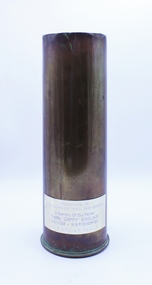
Weapon - Shell case, 18 Pounder Mk II*, Ernest Sinclair, 1917
This 1917 dated 18pr shell case has a plaque in memory of Ernest 'Cappy' Sinclair. WW1 18pr guns were all that was available in the early days of WW2 and were used until the arrival of modern 25pr guns. Ernest served in the 2/2 Pioneer Battalion which was raised in Puckapunyal in Victoria in May 1940. After completing training, the battalion sailed for the Middle East aboard the Queen Mary in April 1941. Brass shell casing with in-memorium plaque attached.Plaque affixed to item: "PRESENTED TO / MONTMORENCEY RSL SUB BRANCH / In Memory Of Our Father / EARN "CAPPY" SINCLAIR / VX74235 - 2/2 PIONEER BN / THE SINCLAIR FAMILY" Engravings from original shell on bottom (see image)shell, 2/2 pioneer battalion, ernest sinclair, ww2, second world war, vx74235 -
 Montmorency–Eltham RSL Sub Branch
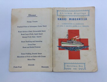
Functional object - Christmas Day Menu H.M.A.H.S. Wanganella
During World War II, Wanganella was converted to serve as an Australian Hospital Ship (AHS). Between 19 May 1941 and 1946, AHS Wanganella carried wounded and sick evacuees from the Middle East, New Guinea, Solomon Islands, Borneo and the South Pacific, travelling over 251,011 nautical miles (464,872 km) and transporting 13,385 wounded. A.H.S Wanganella 2/2nd Australian Hospital ship. Ref: "Hospital Ships" Rupert Goodman SLV LT 359.8364 0994 G62H Trip 8 Depart 12th Nov 1942 Melbourne Fremantle Aden 10th - 11th Dec 1942 Port Tewfik, Egypt 21st - 22nd Dec 1942 Colombo, Sri Lanka 01 Jan 1943 Fremantle Adelaide Melbourne Sydney Arrived 13th Jan 1943 Brisbane Wanganella left Colombo 22nd December 1942 for Fremantle, with patients who boarded at Port Tewfik in Egypt arriving on New Year's day 1943. The menu is printed on fawn cardboard. The menu has been torn along the spine and rearranged at some time to put on display. There is evidence of glue or tape damage at the back of each corner of the card. Some grease and finger marks are evident on the front and back of the card. The printing is very legible. The heading 'Christmas Greetings' is at the top of the front page and 'Christmas Day 1942' at the bottom of the page. Originally the menu was assembled as a leaflet with the menu on the inside of the second sheet. Since this time, the menu has been torn along the middle fold and the second page sheet taped to the first page. There is a red cross on the front page with a printed illustration of the Wanganella superimposed over the top. H.M.A.H.S. Wanganella and the dinner menu are printed in dark blue ink. The Christmas greetings and the names of the commander and officer in command of the troops are printed in light blue ink. h.m.a.h.s. wanganella, w.w.ii hospital ship -
 Montmorency–Eltham RSL Sub Branch
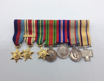
Medal - Medal Group (Miniatures), WW2 Australian Military Forces, VX2151 Pte Andrew Edward Gates
Andrew Edwardson Gates was born on the 30th December 1915 in Carlton, Victoria. He enlisted in South Melbourne on the 4th November 1939 whilst living in East Brunswick, Victoria. Discharged on the 5th October 1945 with the rank of Private.Full set as follows: 1939-1945 Star The Africa Star with 8th Army Bar The Pacific Star 1939-1945 Defence Medal 1939-1945 War Medal 1939-1945 Australia Service Medal 1941 Tobruk Siege Medal with Miniatures The recipients name and service number are impressed on the bottom edge of the 1939-1945 Defence, 1939-1945 War and 1939-1945 Australia Service medals - VX2151, A. E. Gates. A Gates is engraved on the back of the 1941 Tobruk Siege Medal. -
 Montmorency–Eltham RSL Sub Branch
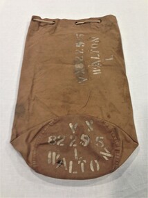
Accessory - Kitbag, Australian Army, WW2
Held by Montmorency/Eltham sub branch for some time; background details uncertain. Likely donated by by family member. Owner was Leslie 'Rocky' Walton (b. 9 Jun 1921) who enlisted at Casino (NSW) on 2 Aug 1942, living at East Preston at the time. He was discharged on 15 April 1946 while posted to 2/43 Aust. Inf. Bn.The kitbag consists of a long, brown, canvas cylinder closed at the bottom. The top has an internal canvas flap and eight brass grommets to allow a drawstring type rope (fitted on this item) to securely close the bag. A metal D-shaped hinged clasp (see photo; 13 cm x 8 cm) to enable fitting of a padlock. A canvas loop (see photo) is sewn to bottom edge of bag to enable rope to be passed through for bag to be slung on shoulder. The name and army serial number of the owner are stenciled in white paint on the side and bottom of the bag. Stenciled on side and bottom of bag ... VX82295 WALTON Laccessory, personal items -
 Montmorency–Eltham RSL Sub Branch
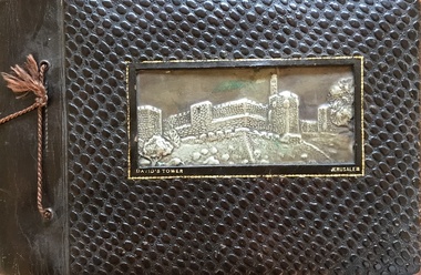
Album - Nicholson Photo Album
Photographic record of overseas places visited by local resident who was a member of armed service during WW2. Des Nicholson was born in Northcote in 1909. He enlisted in the military in mid 1940, having already served 2 years in the Citizens’ Forces. Before he signed up, he lived in Kew with his mother, Isabella. His enlistment documents indicate that he was employed as a transport driver, although his discharge papers state that he was a hairdresser. His photo album shows pictures of him demonstrating skills in that area in various deployments overseas; his enlistment documents refer to his unit being the 8th Division Petrol Company, while for much of his service he was assigned to Nursing Duties in the 2/7 Australian General Hospital. His overseas postings included travels through India to the Middle East, Egypt and Greece. While fulfilling these duties, he was an interested photographer, keeping records of the sights he saw in many of the places he visited, as well as photos of the military living conditions and the people he worked with on a day-to-day basis. The ‘tourist’ photos Des took would be of particular interest as a current-day comparison for those folk who might be familiar with the locations he passed through. After the war, Des again lived with his mother but eventually, in 1953, he married Kathleen Watson who lived in Eltham. The wider Watson family was well-known in the area, and the sisters Kathleen and Ruby were residents in the Glen Park area in Eltham North. After Des and Kath married they continued to live in Kath and Ruby’s house near where the current soccer and cricket sporting complex is now located. Ruby never married and they evidently stayed in the same place until, one by one, they each died in the early 2000s. Photos taken by a resident of Eltham while on active service overseasPhoto AlbumOn Front Cover: DAVID'S TOWER JERUSALEMphotographs, ww2, overseas, india, middle east -
 Greensborough Historical Society
Book, Nillumbik Shire Council, 1997 Community Guide Nillumbik, 1997_
Guide to services provided by Nillumbik Shire Council. Nillumbik Shire is located 25 kilometres north-east of Melbourne and the southern boundary is the Yarra River. The south of Nillumbik is predominantly urban, with commercial centres at Eltham and Diamond Creek. The north of the municipality includes significant natural features like Kinglake National Park and Sugarloaf ReservoirAnnual guide to services in Nillumbik. 64 pages. Cover is pale yellow with colour drawings. nillumbik shire council, handbooks -
 Greensborough Historical Society
Book, Nillumbik Shire Council, 1998 Community Guide Nillumbik, 1998_
Guide to services provided by Nillumbik Shire Council. Nillumbik Shire is located 25 kilometres north-east of Melbourne and the southern boundary is the Yarra River. The south of Nillumbik is predominantly urban, with commercial centres at Eltham and Diamond Creek. The north of the municipality includes significant natural features like Kinglake National Park and Sugarloaf ReservoirAnnual guide to services in Nillumbik 72 pages. Cover has white background and some 3-D artwork.nillumbik shire council, handbooks -
 Greensborough Historical Society
Book, Nillumbik Shire Council, 1999 Community Guide Nillumbik, 1999_
Guide to services provided by Nillumbik Shire Council. Nillumbik Shire is located 25 kilometres north-east of Melbourne and the southern boundary is the Yarra River. The south of Nillumbik is predominantly urban, with commercial centres at Eltham and Diamond Creek. The north of the municipality includes significant natural features like Kinglake National Park and Sugarloaf ReservoirAnnual guide to services in Nillumbik76 pages, illus. Cover has photographs of local people and title in white on orange background.nillumbik shire council, handbooks -
 Greensborough Historical Society
Book, Nillumbik Shire Council, Nillumbik Community Guide 2000/2001, 2000-2001
Guide to services provided by Nillumbik Shire Council. Nillumbik Shire is located 25 kilometres north-east of Melbourne and the southern boundary is the Yarra River. The south of Nillumbik is predominantly urban, with commercial centres at Eltham and Diamond Creek. The north of the municipality includes significant natural features like Kinglake National Park and Sugarloaf ReservoirAnnual guide to services in Nillumbik76 pages, black and white illustrations. Cover has a collage of local children with title in white on mid-blue background.nillumbik shire council, handbooks -
 Greensborough Historical Society
Map, Heidelberg: Historic River Landscape Assessment. Historical maps. Map E 1901-1934 "A Time of projects and improvements", 1985c
Geographical area of around 35 sq. kilometres marked with physical features such as major roads, railways (new extension to Eltham), rivers and properties, also housing sub-divisions and community facilities such as hospitals, parks and sporting reserves and indications of new small scale industries such as dairying. Bounded by Shire of Diamond Valley to the North, Darebin Creek to the West and Plenty River to the East. Black and white sketch map on white paperheidelberg, heidelberg - maps -
 Greensborough Historical Society
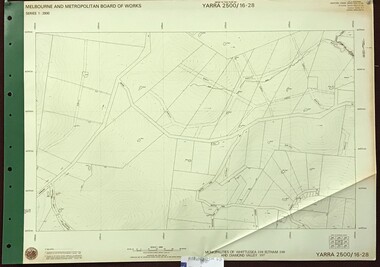
Map, Melbourne and Metropolitan Board of Works. Survey Division, MMBW, Yarra 2500 / 16.28. East of Hurstbridge, 1977_10
Melbourne and Metropolitan Board of Works. Yarra 2500 [base map] 16.28. East of Hurstbridge. Municipalities of Whittlesea 239, Eltham 238 and Diamond Valley 257. Prominent streets include: Boyds Road, Bannons Lane and Wattle Tree Road. MMBW Map in 1:2500 [scale] series. Cream parchment with green tape reinforcing on edges and punched holes on left edge.mmbw, melbourne and metropolitan board of works, shire of diamond valley -
 Eltham District Historical Society Inc
Photograph, Edendale Farm, Eltham Heritage Tour, 24 May 1992, 24/05/1992
ELTHAM HERITAGE TOUR The Society excursion on 24th May 1992 was arranged by David Bick, leader of the team carrying out the Shire's heritage study. David selected a number of sites or buildings identified in the study, some of them lesser known components of the Shire's heritage. The tour commenced at the Eltham Shire Office at 10.00 am. Travel was by private car and mini-bus with stops at about twelve locations for commentary by David.It included a short walk in Hurstbridge and lunch at Kinglake. Highlights of the tour included: - 10 am Leave from Shire Offices - 3 Important Trees - A Physical Link to Eltham's First Settlers - Toorak Mansion Gates - A Surviving Farm House - An Intact Circa 1900 Main Street - First Settlers - Gold Miners, and Timber-getters - An Early Hotel - A Pioneering Homestead - Changing Eltham Shire - 20th Century - 4 pm Afternoon Tea and Finish Tour Extract from ELTHAM CULTURAL HERITAGE TOUR (Newsletter No. 85, July 1992, by Bettina Woodburn) "The land was unprofitable for intensive farming, but there was always water in the Diamond Creek. The railway, a technological advance, followed the valley, and was provided to transport produce. At North Eltham we were privileged to tour a surviving farmhouse of the 1860-70 era at the Shire’s Edendale Farm, with the as yet unfinished Sculpture for a front fence - bulbous tree-trunks decorated with salt pots, with cross members from the old trestle bridge. As was usual these six veranda posted houses faced South (or East, away from the sun!) with the scullery, kitchen and pantry "out the back". The veranda, which must have been very narrow, no longer exists. It probably wrapped around three sides. The drive took us past the Dutch Windmill, only twenty years old and in the Shire of Diamond Valley, then the Diamond Creek Cemetery with impressive gateway, to a detour to see another old farmhouse, isolated on a hill off Murray Road Wattle Glen. Here was a particularly thick patch of exotic planting of pines and cypresses. Subsistence farming no longer pays. Following the rail-line we noticed on the left near Silvan Road an Edwardian cottage and on the right near Yates Road the old school residence for this Upper Diamond Creek area."Record of the Society's history and activities and highlighting various aspects of the Heritage Study undertaken by David Bick used to create the future heritage overlay for the Shire of Eltham and later Nillumbik Shire.Roll of 35mm colour negative film, 4 stripsKodak Gold 100 5095eltham, shire of eltham historical society, activities, heritage tour -
 Eltham District Historical Society Inc
Photograph, Kangaroo Ground War Memorial, Eltham Heritage Tour, 24 May 1992, 24/05/1992
ELTHAM HERITAGE TOUR The Society excursion on 24th May 1992 was arranged by David Bick, leader of the team carrying out the Shire's heritage study. David selected a number of sites or buildings identified in the study, some of them lesser known components of the Shire's heritage. The tour commenced at the Eltham Shire Office at 10.00 am. Travel was by private car and mini-bus with stops at about twelve locations for commentary by David.It included a short walk in Hurstbridge and lunch at Kinglake. Highlights of the tour included: - 10 am Leave from Shire Offices - 3 Important Trees - A Physical Link to Eltham's First Settlers - Toorak Mansion Gates - A Surviving Farm House - An Intact Circa 1900 Main Street - First Settlers - Gold Miners, and Timber-getters - An Early Hotel - A Pioneering Homestead - Changing Eltham Shire - 20th Century - 4 pm Afternoon Tea and Finish Tour Extract from ELTHAM CULTURAL HERITAGE TOUR (Newsletter No. 85, July 1992, by Bettina Woodburn) "Now we drove through stands of pines to the Kangaroo Ground Lookout Tower, a most unusual War Memorial, World War I. The tower and a shed/residence (it had a chimney) were built from local sandstone. Below to the south and east of Melbourne spread 'suburbia'. Close by the landscape seemed so contrived - English fields and hedgerows! Although only about twenty inches deep, the soil of this ancient volcano, its crater lost under subsequent weathering, was rich, deserving the name of "Garden Hill". Now native trees are taking over again. In Kangaroo Ground itself stand the inevitable Store, School and Church - and two Norfolk pines and a monkey puzzle tree."Record of the Society's history and activities and highlighting various aspects of the Heritage Study undertaken by David Bick used to create the future heritage overlay for the Shire of Eltham and later Nillumbik Shire.Roll of 35mm colour negative film, 4 stripsKodak Gold 100 5095shire of eltham historical society, activities, heritage tour, kangaroo ground, kangaroo ground tower, war memorials, kangaroo ground memorial -
 Eltham District Historical Society Inc
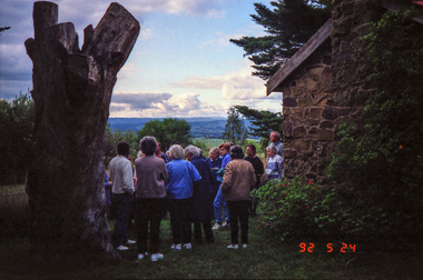
Photograph, Shire of Eltham War Memorial, Memorial Park, Garden Hill, Kangaroo Ground; Eltham Heritage Tour, 24 May 1992, 24/05/1992
ELTHAM HERITAGE TOUR The Society excursion on 24th May 1992 was arranged by David Bick, leader of the team carrying out the Shire's heritage study. David selected a number of sites or buildings identified in the study, some of them lesser known components of the Shire's heritage. The tour commenced at the Eltham Shire Office at 10.00 am. Travel was by private car and mini-bus with stops at about twelve locations for commentary by David.It included a short walk in Hurstbridge and lunch at Kinglake. Highlights of the tour included: - 10 am Leave from Shire Offices - 3 Important Trees - A Physical Link to Eltham's First Settlers - Toorak Mansion Gates - A Surviving Farm House - An Intact Circa 1900 Main Street - First Settlers - Gold Miners, and Timber-getters - An Early Hotel - A Pioneering Homestead - Changing Eltham Shire - 20th Century - 4 pm Afternoon Tea and Finish Tour Extract from ELTHAM CULTURAL HERITAGE TOUR (Newsletter No. 85, July 1992, by Bettina Woodburn) "Now we drove through stands of pines to the Kangaroo Ground Lookout Tower, a most unusual War Memorial, World War I. The tower and a shed/residence (it had a chimney) were built from local sandstone. Below to the south and east of Melbourne spread 'suburbia'. Close by the landscape seemed so contrived - English fields and hedgerows! Although only about twenty inches deep, the soil of this ancient volcano, its crater lost under subsequent weathering, was rich, deserving the name of "Garden Hill". Now native trees are taking over again. In Kangaroo Ground itself stand the inevitable Store, School and Church - and two Norfolk pines and a monkey puzzle tree." On November 11th 1926 the Shire of Eltham War Memorial Tower at Kangaroo Ground was opened. It is regarded as one of Melbourne’s most outstanding lookout towers. It commands a magnificent 360 degree panorama from Kinglake across the Diamond Valley to Macedon and the You Yangs. It is built on a peak which was once a volcano, 237 metres above sea level. After World War one a memorial cairn was erected on the site, and in 1925 a committee of public-minded citizens began to plan for a tower. Many generous donations of material and money were forthcoming so that in 1926 the Governor General Lord Stonehaven was able to unveil the plaque before a crowd of 500 people. There was some concern in the 1960s when the Forests Commission wanted to build a firespotters cabin on the top. At first R.S.L. branches opposed the idea, but it was realised that this use could combine with its use as a tourist attraction, and would ensure its maintenance for the future, Today the Kangaroo Ground tower provides one of the best views around Melbourne and is a fitting memorial to those who died in two world wars. From: Historic items for Diamond Valley Community Radio September 1990 (EDHS collection) Record of the Society's history and activities and highlighting various aspects of the Heritage Study undertaken by David Bick used to create the future heritage overlay for the Shire of Eltham and later Nillumbik Shire.Roll of 35mm colour negative film, 4 stripsKodak Gold 100 5095culture, events, garden hill, kangaroo ground, kangaroo ground memorial, memorial park, shire of eltham war memorial tower, war memorials -
 Eltham District Historical Society Inc
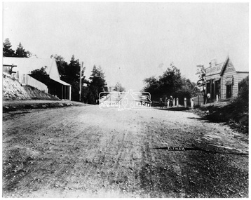
Negative - Photograph, Main Road, Eltham, looking south from Bridge Street, 1906-1907
Looking south along Main Road from the south side of the intersection of Bridge Street with Main Road. Anne Hunniford's Post Office and Burgoyne's store on left. Miss Harriet (Minnie) Williams's Cash Drapery Mart (est. 1902 and enlarged in 1906), also known as Eltham House on the right. Harriet (Minnie) Williams was born London, 1857, the daughter of George John Williams (1812-1895) and Jane Mansfield (1812-1895). In September 1885 she was operating Williams’s Drapery Establishment in premises on Main Road owned by R. Wallis who advertised them to let in September 1885. In 1902 she opened Williams’s Cash Drapery Mart at the southwest corner of Bridge Street and Main Road (opposite the Post Office), owned by W.J. Taylor. In 1906 she bought the premises and one quarter acre of land and expanded the business with a re-opening in April 1906. Harriet was also well-known and esteemed as an active worker in Methodist circles and also Superintendent of the Sunday School. Harriet fell ill in August 1907 and died 15 August. She is buried in Eltham Cemetery with her good friend Ada Ford. Evelyn Observer and Bourke East Record (Vic. : 1902 - 1917), Friday 30 March 1906, page 5 ________________________________________ ELTHAM. (FROM OUR OWN CORRESPONDENT.) For over three years Miss Williams has carried on a drapery business in very small and inconvenient premises opposite the Eltham post-office. Recently she bought the building and a quarter-acre of land from Mr. W. J. Taylor. Thus having a free hand, she at once matured plans to enlarge and improve the premises to make them suitable for her growing business. The result being that she consulted Mr Roach, contractor, of Heidelberg, put the matter in his hands, and now he has completed in a very satisfactory manner and up-to-date style extensive improvements. A large addition, of very neat and attractive design, with three large windows, has been built right along the front of the old building, and the counters and inside fittings are very neat and convenient, harmonizing well with the attractive outside appearance. Miss Williams has now got in a large now stock of goods, and is making extensive arrangements for a “reopening week," commencing 2nd April, during which time she will make 10 per cent reduction on all cash purchases in the form of gifts of that value. Miss Williams has gone to considerable expense and liability both, in the enlargement and improvement of the premises and in purchasing additional stock. We therefore trust that the public will stand by her by heartily and en masse patronizing her re-opening effort to show their appreciation of pluck in this advance movement. Google Street View Feb 2017: https://www.google.com.au/maps/@-37.7191341,145.1462046,3a,50.5y,191.91h,88.27t/data=!3m6!1e1!3m4!1sARwwqEQfMSfH9oTWWapPgQ!2e0!7i13312!8i6656This photo forms part of a collection of photographs gathered by the Shire of Eltham for their centenary project book,"Pioneers and Painters: 100 years of the Shire of Eltham" by Alan Marshall (1971). The collection of over 500 images is held in partnership between Eltham District Historical Society and Yarra Plenty Regional Library (Eltham Library) and is now formally known as the 'The Shire of Eltham Pioneers Photograph Collection.' It is significant in being the first community sourced collection representing the places and people of the Shire's first one hundred years.Digital image 4 x 5 inch B&W Negsepp, shire of eltham pioneers photograph collection, eltham, main road, anne jane hunniford, burgoyne store, christopher watson, commercial bank of australia, drapery store, eltham house, harriet (minnie) williams, post office, watson's hotel, williams's cash drapery mart -
 Eltham District Historical Society Inc
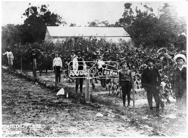
Negative - Photograph, Experimental plots, Eltham State School, 1908
ELTHAM. (1908, October 30). Evelyn Observer and Bourke East Record (Vic. : 1902 - 1917), p. 2 (MORNING.). Retrieved May 3, 2020, from http://nla.gov.au/nla.news-article60648129 The experimental plots at the local State School are now planted and are under the supervision of Mr. H. Heape and the Head Teacher, Mr. Fisher. The artificial manures have been supplied by the Colonial Manure Co., of Collins Street, and the result of the experiments will be anxiously looked for by all concerned. Reproduced on p67 of 'Pioneers & Painters'This photo forms part of a collection of photographs gathered by the Shire of Eltham for their centenary project book,"Pioneers and Painters: 100 years of the Shire of Eltham" by Alan Marshall (1971). The collection of over 500 images is held in partnership between Eltham District Historical Society and Yarra Plenty Regional Library (Eltham Library) and is now formally known as the 'The Shire of Eltham Pioneers Photograph Collection.' It is significant in being the first community sourced collection representing the places and people of the Shire's first one hundred years.Digital image 4 x 5 inch B&W Negsepp, shire of eltham pioneers photograph collection, eltham, experimental plots -
 Eltham District Historical Society Inc
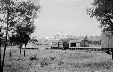
Negative - Photograph, Eltham Railway Station, c.1912
Viewed from the western side looking north east. A Tait rail car and Guard's van are parked at the platform.This photo forms part of a collection of photographs gathered by the Shire of Eltham for their centenary project book,"Pioneers and Painters: 100 years of the Shire of Eltham" by Alan Marshall (1971). The collection of over 500 images is held in partnership between Eltham District Historical Society and Yarra Plenty Regional Library (Eltham Library) and is now formally known as the 'The Shire of Eltham Pioneers Photograph Collection.' It is significant in being the first community sourced collection representing the places and people of the Shire's first one hundred years.Digital image 4 x 5 inch B&W Neg Print B&Wsepp, shire of eltham pioneers photograph collection, eltham, railway station -
 Eltham District Historical Society Inc
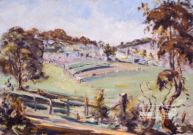
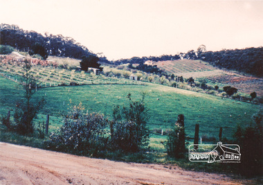
Photograph, Bird family Orchard, Pitt Street, Eltham, c.1980s
View looking northeast from near junction of Wattle Grove and Mount Pleasant Road across to Eucalyptus Road on right and Pitt Street at top. Early pioneer, George Bird Snr. arrived from England in 1852 and lived with his uncle, George Stebbing. He worked for him as bricklayer's assistant in building, among others, the Anglican and Methodist Churches in Eltham. In 1862 he purchased land in the east end of Pitt Street bounded by Eucalyptus Road and Wattle Grove and established a mixed farm and orchard. His son, Arthur Bird succeeded him and also worked on this orchard which then passed to Arthur's son, Harold Bird OAM, where Harold and Yvonne Bird lived in the family home till the mid 2000s A4 size photographic print reproduction of a paintingaos6, wattle grove, pitt street, arthur bird, bird family orchard, eucalyptus road, george bird, harold bird, yvonne bird, eltham -
 Eltham District Historical Society Inc
Photograph, Bird family Orchard, Pitt Street, Eltham, c.1980s, 1980s
View looking northeast from near junction of Wattle Grove and Mount Pleasant Road across to Eucalyptus Road on right and Pitt Street at top. Early pioneer, George Bird Snr. arrived from England in 1852 and lived with his uncle, George Stebbing. He worked for him as bricklayer's assistant in building, among others, the Anglican and Methodist Churches in Eltham. In 1862 he purchased land in the east end of Pitt Street bounded by Eucalyptus Road and Wattle Grove and established a mixed farm and orchard. His son, Arthur Bird succeeded him and also worked on this orchard which then passed to Arthur's son, Harold Bird OAM, where Harold and Yvonne Bird lived in the family home till the mid 2000s A4 size photographic printaos6, wattle grove, pitt street, arthur bird, bird family orchard, eucalyptus road, george bird, harold bird, yvonne bird, eltham -
 Eltham District Historical Society Inc
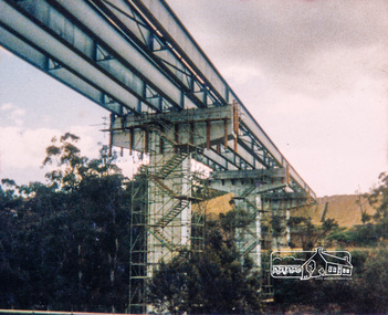
Photograph, Looking east across the new 5-span bridge construction across the Plenty River from the western side; Greensborough Bypass construction, c.1986, 1986c
Shows the eastern bridge of the Greensborough Bypass under construction. Colour photograph originally located in a magnetic style album titled 'Greensborough Bypass 1990s 5' suffering significant degradation. No information contained in album or on reverse of photos except where noted. Relocated to archival photosafe storage.greensborough bypass, road construction, plenty river drive, greensborough, bridge construction -
 Eltham District Historical Society Inc
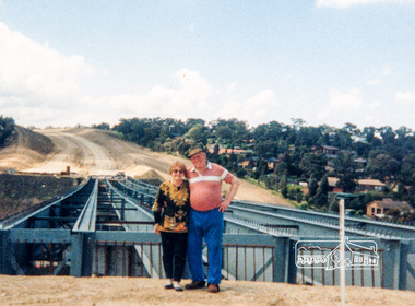
Photograph, Looking east across the new bridge construction across the Plenty River from the western side up to the new roundabout at Civic Drive; Greensborough Bypass construction, c.1986, 1986c
Colour photograph originally located in a magnetic style album titled 'Greensborough Bypass 1990s 5' suffering significant degradation. No information contained in album or on reverse of photos except where noted. Relocated to archival photosafe storage.greensborough bypass, road construction, greensborough, bridge construction -
 Eltham District Historical Society Inc
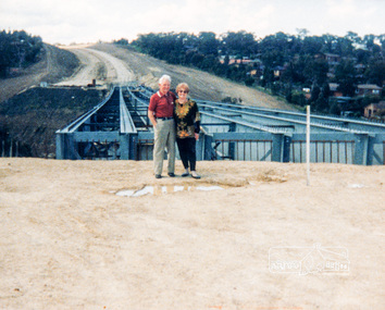
Photograph, Looking east across the new bridge construction across the Plenty River from the western side up to the new roundabout at Civic Drive; Greensborough Bypass construction, c.1986, 1986c
Colour photograph originally located in a magnetic style album titled 'Greensborough Bypass 1990s 5' suffering significant degradation. No information contained in album or on reverse of photos except where noted. Relocated to archival photosafe storage.greensborough bypass, road construction, greensborough, bridge construction