Showing 1088 items matching "geology"
-
 Ringwood and District Historical Society
Photographs, 1979-80 MMBW pipe line project at Hubbard Reserve, North Ringwood � Drill rig
Part of a 43-photo record of the MMBW�s engineering feat in drilling a 12 inch pipe line up to 40 feet deep through rock hardened by volcanic action associated with geological fault that occurs along the line. The work took place from October 1979 to May 1980 on the southern boundary of Hubbard Reserve, North Ringwood. The collection was presented to the Ringwood Historical Research Group by J Clarke on 9th June 1980.E561 N17 3 March 1980 A43 Powder-monkey marks out the spots for holes -
 Ringwood and District Historical Society
Photographs, 1979-80 MMBW pipe line project at Hubbard Reserve, North Ringwood � View towards Debbie Place
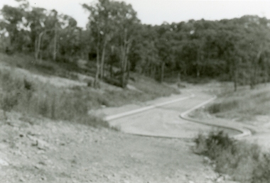
Part of a 43-photo record of the MMBW�s engineering feat in drilling a 12 inch pipe line up to 40 feet deep through rock hardened by volcanic action associated with geological fault that occurs along the line. The work took place from October 1979 to May 1980 on the southern boundary of Hubbard Reserve, North Ringwood. The collection was presented to the Ringwood Historical Research Group by J Clarke on 9th June 1980.E561 N15 3 March 1980 A43 View towards Debbie Place, showing 2 swivel cranes at shafts, timber of manhole in creek, the tracked drill rig and its compressor caravan. -
 Ringwood and District Historical Society
Photographs, 1979-80 MMBW pipe line project at Hubbard Reserve, North Ringwood � Boring mole pit
Part of a 43-photo record of the MMBW�s engineering feat in drilling a 12 inch pipe line up to 40 feet deep through rock hardened by volcanic action associated with geological fault that occurs along the line. The work took place from October 1979 to May 1980 on the southern boundary of Hubbard Reserve, North Ringwood. The collection was presented to the Ringwood Historical Research Group by J Clarke on 9th June 1980.E561 N14 3 March 1980 A43 View west behind No. 29 Burlock Avenue, showing gantry over manhole 38 feet deep. -
 Ringwood and District Historical Society
Photographs, 1979-80 MMBW pipe line project at Hubbard Reserve, North Ringwood � The work on sewer line from 29-39 Burlock Avenue
Part of a 43-photo record of the MMBW�s engineering feat in drilling a 12 inch pipe line up to 40 feet deep through rock hardened by volcanic action associated with geological fault that occurs along the line. The work took place from October 1979 to May 1980 on the southern boundary of Hubbard Reserve, North Ringwood. The collection was presented to the Ringwood Historical Research Group by J Clarke on 9th June 1980.E561 N11 3 March 1980 A43 The work on sewer line from 29-39 Burlock Avenue. Lundy-Clarke's place on sky-line. -
 Ringwood and District Historical Society
Photograph, 1979-80 MMBW pipe line project at Hubbard Reserve, North Ringwood. Debbie Place from the east end
Part of a 43-photo record of the MMBW's engineering feat in drilling a 12 inch pipe line up to 40 feet deep through rock hardened by volcanic action associated with geological fault that occurs along the line. The work took place from October 1979 to May 1980 on the southern boundary of Hubbard Reserve, North Ringwood. The collection was presented to the Ringwood Historical Research Group by J Clarke on 9th June 1980.E550 N12 Dec 1979 A43 Debbie Place from the east end -
 Ringwood and District Historical Society
Photographs, 1979-80 MMBW pipe line project at Hubbard Reserve, North Ringwood � View from Debbie Place, preliminary sewer work
Part of a 43-photo record of the MMBW�s engineering feat in drilling a 12 inch pipe line up to 40 feet deep through rock hardened by volcanic action associated with geological fault that occurs along the line. The work took place from October 1979 to May 1980 on the southern boundary of Hubbard Reserve, North Ringwood. The collection was presented to the Ringwood Historical Research Group by J Clarke on 9th June 1980.E561 N13 28 Feb 1980 A43 View from Debbie Place, preliminary sewer work -
 Ringwood and District Historical Society
Photographs, 1979-80 MMBW pipe line project at Hubbard Reserve, North Ringwood � Line of tunnel shafts behind 29-39 Burlock Avenue
Part of a 43-photo record of the MMBW�s engineering feat in drilling a 12 inch pipe line up to 40 feet deep through rock hardened by volcanic action associated with geological fault that occurs along the line. The work took place from October 1979 to May 1980 on the southern boundary of Hubbard Reserve, North Ringwood. The collection was presented to the Ringwood Historical Research Group by J Clarke on 9th June 1980.E561 N10 Feb 1980 A43 Line of tunnel shafts behind 29-39 Burlock Avenue. Horizontal gantry was above the manhole in the corner of No. 29. -
 Ringwood and District Historical Society
Photographs, 1979-80 MMBW pipe line project at Hubbard Reserve, North Ringwood � First hole west of bore hole at 39 Burlock Avenue
Part of a 43-photo record of the MMBW�s engineering feat in drilling a 12 inch pipe line up to 40 feet deep through rock hardened by volcanic action associated with geological fault that occurs along the line. The work took place from October 1979 to May 1980 on the southern boundary of Hubbard Reserve, North Ringwood. The collection was presented to the Ringwood Historical Research Group by J Clarke on 9th June 1980.E561 N9 Feb 1980 A43 First hole west of bore hole at 39 Burlock Avenue -
 Bendigo Historical Society Inc.
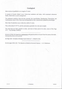
Document - MINING REPORTS - GEOLOGICAL REPORT OF MAIN SECTION OF GOLDFIELD
Handwritten notes by Albert Richardson, with typed copy, on a Geological report of main section in a length of 5 miles. Report mentions sandstones and slates, with occasional calcareous bands, which show a cyclic arrangement. Also mentioned are different zones of sediments, anticlines, structure of the field and references: Page 1028 Formation of Bendigo Quartz Reefs by F R Stilwell to 1032 and pages 160 to 163 'Ore deposits as Related to Structural Features - A H Newhouse. document, gold, mining reports, mining reports, geological report of main section of goldfield, the bendigo goldfields page 1015, formation of bendigo quartz reefs by f r stilwell page 1028 to 1032, ore deposits as related to structural features pages 160 to 163 a h newhouse -
 Bendigo Historical Society Inc.
Document - VICTORIA HILL - QUESTION 5 ON VICTORIA HILL
Handwritten notes and carbon copy titled Question 5. Notes refer to Victoria Hill being opened up by Theodore Ballerstedt and his son early in 1854. Theodore Ballerstedt left for Germany having sold his home, crushing battery and mine to Mr. Geo Lansell. He called the mine the '180'. Next mine north to the '180' was the Victoria Quartz. Also contains notes on machinery, geological formations and earning from the mines.document, gold, victoria hill, victoria hill, question 5 on victoria hill, theodore ballerstedt, mr geo lansell, fortuna villa, commonwealth survey regiment, the 180, ballerstedt's original open cut, bendigo south rotary club, john wybrandt, north old chum coy, victoria quartz, victoria reef quartz company, mr william rae, a roberts & sons united ironworks, australian mining standard special edition 1899, bendigo advertiser 10/2/1897, a harkness & coy, bendigo advertiser 30/6/1910 page 5, rae's open cut, e j dunn, bendigo saddle reefs, wittscheibe's 'jeweller's shop', roberts & frost, ashley noy & coy, grant & co, woodward & son, couth allen and co, taylor gould and co, crawshaw & co, roberts & co -
 Federation University Historical Collection
Book, Final recommendations Ballarat Study Area Land Conservation Council, Victoria, 1982, 1982
Yellow soft covered report of 95 pages . The contents of the report include: Parks, reference areas, wildlife reserves, water production, hardwood production, softwood production, flora Reserves and Flora and Fauna reserves, bushland reserves, historic area and reserves, rivers and streams, Roadside conservation and Highway parks, Education areas and School Plantations, Lake Reserves, geological reserves, recreation, scenic reserves, agriculture, mineral and stone production, utilities and survey, township land, Uncommitted Land, military training, other reserves and public land. Maps include: The Study area 1: 250 000 Supplementary Mapsland conservation authority, ballarat, endowment plantations, pine plantations, langi ghiran state park, mount buangor state park, enfield state park, ballarat-creswick regional park, rossbridge, black lake, flax mill swamp, dereel lagoon, lake bolac, lake wongan, langi ghiran reservoir, gong gong reservoir, pincotts reservoir, beales reservoir, wilsons reservoir, moorabool reservoir, korweinguboora, korweinguborra reservoir, learmonth bores, sago hill, illabarook reservoir, ballarat water commission, dunneworthy, mount cole, mont lonarch, ben major, waterloo, trawalla, linton, ross creek, canadian, shepherds flat, lal lal, mount doran, raglan, chute, carngham, buninyong, watsons hill, enfield, cape clear, illabrook, rokewood junction, mount warrenheip, nerrina, jubilee, golden stream, australasian deep lead mine, happy valley school, piggoreet, berringa, bulldog, ballarat common, wildlife, water, timber, flora, rivers, geology, agriculture, warrenheip, biodiversity -
 Bendigo Historical Society Inc.
Map - GEOLOGICAL MAP: BENDIGO GOLD FIELDS
GEOLOGICAL MAP - BENDIGO GOLD FIELDS - Donated by JOHN HORWOOD. Two geological maps of the Bendigo Gold fields. The maps display , reef lines, Hills, Dams and mine locations. Also Anticlines, sinclines, shafts, alluvial deposits, contours and gullys. All items are superimposed on a map of the major roads and streets of Bendigo. The maps were printed by The Victorian Minister for Mines in 1923 and re-issued in 1936. The maps have been specifically framed and donated to The Bendigo Historical Society Inc. in May 2015 for display at Specimen Cottage. John had been a student at The School of Mines- Bendigo and found them useful as a student living in Bendigo. Prior to being framed , the maps have been kept rolled up in his home. Accession Number 309/15 Were on Display at Specimen Cottage 2015 - 2020. After all items removed from SC to the BRAC in 2021 the framed maps could not be located. Search ongoing. BP 2.3.2023Victorian Minister of Minesgoldfields -
 Geoffrey Kaye Museum of Anaesthetic History
Book, Longman, Brown, Green and Longmans, Physical Description of New South Wales and Van Diemen's Land. Accompanied by a geological map, sections, and diagrams, and figures of the organic remains, 1845
Dr. Gwen Wilson, Emeritus historian, gifted this book at ANZCA's first independent Annual Scientific Meeting held in Launceston in 1994. Dr Wilson presented this gift after her speech about the life of William Russ Pugh and his significant contribution to anaesthesia in Australia. It is unclear as to how the book came into Dr Wilson's possession. Published in London, 1845, for Longman, Brown, Green and Longmans, this book was formally owned by general practitioner Dr William Russ Pugh, being the first medical practitioner in Australia to administer ether anaesthetic on 7 June 1847, in Launceston. The author of the book, P E De Strzelecki acknowledges Pugh for his assistance during his stay in Launceston and for allowing him the use of his laboratory for the analysis of the soils and minerals that were subsequently reported in this book (Page 131). Tan coloured cloth book with an embossed circular motif on the centre of the front and back cover. The same embossed motif is repeated four times along the spine of the book. An embossed design of small, four petal flowers borders the edge of the front and back cover. The title of the book 'Strzelecki's New South Wales and Van Diemen's Land' is printed in gold on the spine. The cloth has come unstuck at various places around the spine and a small section is missing from the base of the spine. The cover is worn and has numerous dark stains possibly from mould. The book contains 19 engraved and lithographed plates. This includes a handcoloured octavo folding, geological map, bound as a frontispiece, depicting the NSW coast down to Gippsland and Tasmania, a fold out single colour geological cross section of the Newcastle Coal Basin, 14 plates illustrating shellfish and flora and three tinted lithographs. Single page maps at the back illustrate wind patterns around Australia. [front title page, two black ink stamps that have bled through to the next page] W R.PUGH [front title page, black ink, cursive writing] H Grant \ 5 May 1910 [front title page, pencil, cursive writing, written around Pugh's stamp] Purchased from \ (unrecognizable script) [front title page, previous owner's name was rubbed out and consequently tore the page making the entry unreadable] [Inner back cover, bottom LHS, blue stamp] BOUND BY \ WESTLEYS & \ CLARK \ LONDON [Inner front cover, bottom LHS, black and purple ink] P65 \ 76 \ 78 \ 98 \ 163 \ 164 \ 217strzelecki, van diemen's land, wilson, gwen, pugh, william, launceston, green and longmans -
Federation University Historical Collection
Book - Course Guide, University of Ballarat Program Guide 2012/13, 2012
Couloured cover, predominantly in ochre, with a young man's face featuring. Contents include: Applications. Deferring. VTAC, fees, financial assistance, scholarships, TAFE, Campuses, Exchange Universities, Stawell Campus, Camp Street Campus, Arts Academy, SMB Campus, Mt Helen Campus, Ararat Campus, Horsham Campus, UB Tec, Student Experience office, Student Living Skills, Aboriginal Education Centre, Student Learning Skills, Conselling, UB PASS, UB Ready, SMB Fitness Centre, Disability, Helat Services, Alumni, Gold Key Chapter, Student Res, idences, apprenticeships, traineeships, unisports, ceramics, acting, teaching, nursing, human movement, Nick Driden, engineering, geology, mining, equineapplications. deferring. vtac, fees, financial assistance, scholarships, tafe, campuses, exchange universities, stawell campus, camp street campus, arts academy, smb campus, mt helen campus, ararat campus, horsham campus, ub tec, student experience office, student living skills, aboriginal education centre, student learning skills, conselling, ub pass, ub ready, smb fitness centre, disability, helat services, alumni, gold key chapter, student res, idences, apprenticeships, traineeships, unisports, ceramics, acting, teaching, nursing, human movement, nick driden, engineering, geology, mining, equine, courses, handbook -
 Federation University Historical Collection
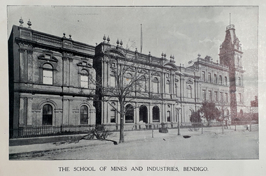
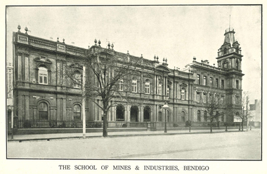
Booklet - Booklet - Prospectus, Cambridge & Leaney Printers, Bendigo Junior Technical School, School of Mines, Prospectus 1913, 1913
The Bendigo School of Mines was opened in 1873 to meet the scientific and technical needs of the mining industry on the local gold fields. Mining, chemistry, geology, metallurgy and art were taught. In c.1907 a Junior Technical School commenced to operate at the School of Mines and Industry. This was to enable boys who had completed primary school the opportunity to continue their education and learn skills to assist them in their future. In c.1961 the Junior Technical School ceased to operate with that function being transferred to the White Hills and Kangaroo Flat technical schools.Red/brown soft covered booklet.A.W Steane written on front coverbendigo junior technical school, prospectus, w.h walter, j.r.v anderson, a.w. steane, w.s. lake, k.c. abbott, mr grant, mathematics and science, woodwork and sheet metal, art, principal, bendigo -
 Federation University Historical Collection
Booklet, Cambridge Press Bendigo, Bendigo Junior Technical School Prospectus, 1914, 1914
The Bendigo School of Mines was opened in 1873 to meet the scientific and technical needs of the mining industry on the local gold fields. Mining, chemistry, geology, metallurgy and art were taught. In c.1907 a Junior Technical School commenced to operate at the School of Mines and Industry. This was to enable boys who had completed primary school the opportunity to continue their education and learn skills to assist them in their future. In c.1961 the Junior Technical School ceased to operate with that function being transferred to the White Hills and Kangaroo Flat technical schools.Grey soft covered booklet with green printing. The prospectus outlines preparatory courses in Trade, Art and Science. Photographs include Physical Culture, Geometrical Development, Science Laboratory, Design, Sheetmetal, Woodwork and Modelling.Handwritten on front Cover A.W. Steanebendigo junior technical school, prospectus, head master, a e tutton, mathematics and science master, j a donald, woodwork and sheet matal, h f day, crafts master, k c abbott -
 Nillumbik Shire Council
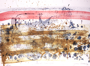
Print (Lithograph): John Olsen (b.1928 NSW), John Olsen, Tropical Rain Shower from The Bodford Terrace Suite, 1978
A typical Olsen painting combines an implied aerial view with an ambiguous and seemingly unpremeditated figuration. His characteristically quizzical line and irregular squiggles and dots deftly render countless organisms, large and minute. Their environment is conjured through loosely brushed and stained expanses of colour (on canvas or hardboard) and lines which sometimes read as geological mappings. In Olsen's work there is no foreground/ middle ground/ background, nor any sign of European landscape's concern with "human scale." Instead he employs simultaneously the contrary vantages of naturalist and geographer. 'Tropical Rain Shower' by John Olsen forms one of the eight artworks represented in the Bodford Terrace Suite. Eight of Australia's finest artists were brought together to create a folio of lithographic prints to celebrate the restoration of historic Bodford Terrace. Printed at the Druckma Press by John Robinson under the supervision of master printer Jock Abbott. The folio edition was limited to 300 signed and numbered folios. The lithographs were printed on special heavy weight french Arche's paper in accordance with the tradition of this artistic medium. Lithographic print on paper.Signed John Olsen '78, lower right hand corner. Edition 179/300bodfford terrace collection, john olsen, tropical rain shower -
 Federation University Historical Collection
Book, Cassell, Petter, Galpin & Co, Popular Educator Vol. 5
Green/black clothcovered book of 412 pages. Includes illustrations and topics such as Knights Templar, Red Cross Knights, Lesson in Architecture, botany, arithmetic, algebra, static forces, Cambridge University, chemistry, latin, Euclid, fossils, geology, Greek, Electricity, German, Organic Chemistry, shells, pearls, North America, nightshades, the Thirty Years War, commerce, reflection of light, book-keeping, mosses, South America, hydrostatics, camera obscura, London UniversityStamped 'Springs Public Libray'cambridge university, knights templar, red cross knights, organic chemistry, north america, thirty years war, south america, camera obscura, london university, springs public library -
Federation University Historical Collection
Document, Pat Hope (Dean of Business and Information Management), Ballarat University College Prizes and Scholarships, 1991, 26/02/1991
A prize is a reward granted in recognition of excellence, such as cash, an article as a book or a medal, or both. A scholarship is a grant for the maintenance of a student. 12 page typed document relating to prizes and scholarships offered at Ballarat University College, and their conditions for award. Prizes in 1990 included the following: Chemistry, Josephine Brelaz (Physics, Metallurgy, Multi-disciplinary Science, Electrical Engineering, Civil Engineering), Harold Yates (Geology), Martha Pinkerton (Art), Adrienne Guy Award (Art), Librarianship, Business, Mica Smith (Mining Engineering), Mary Allnutt Award (Humanities and Social Sciences), R.W. Richards Medal.ballarat university college, prizes, awards, scholarships, r.w. richards medal, josephine brelaz award,, martha pinkerton award, adrienne guy award, mica-smith award, mary allnutt award, martha pinkerton, scholarships -
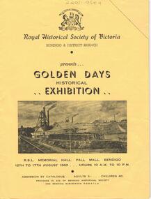 Bendigo Historical Society Inc.
Document - LYDIA CHANCELLOR COLLECTION: ROYAL HISTORICAL SOCIETY OF VICTORIA
A yellow catalogue published by the Royal Historical Society of Victoria Bendigo & District Branch. It is presenting the ' Golden Days Historical Exhibition ' at the R.S.L. Memorial Hall, Pall Mall, Bendigo 12th to 17th August 1960. The categories of exhibits are antiques, bush ranging, coins and tokens, documents, fashions, firearms, geology, gold mining, pioneers, postal history, prints and photography, shipping and sport. Within the catalogue are Bendigo Advertiser July and August cuttings relating to the exhibition.history, australian, exhibition, lydia chancellor collection, collection, bendigo, australia, royal historical society of victoria, exhibits, bendigo city council -
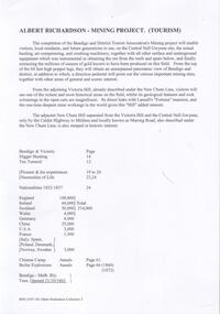 Bendigo Historical Society Inc.
Document - VICTORIA HILL - NOTES ON VICTORIA HILL
Handwritten notes and typed copy, on Victoria Hill. Notes mention the completion of the Bendigo and District Tourist Association's Mining project, what can be seen in the area, the views of Bendigo from the top of the 68 feet high poppet legs, geological features and rock colourings in the open cuts, its direct link to Fortuna mansion and the one-time deepest mine workings in the world. On the back is a number of references and page numbers. Notes prepared by Albert Richardson.document, memo, victoria hill, victoria hill, notes on victoria hill, bendigo and district tourist association, new chum line, lansell's fortuna mansion, central nell gwynne -
 Bendigo Historical Society Inc.
Map - HUSTLER'S REEF MINE - EAST & WEST CROSS-CUTS, NORTH & SOUTH OF SHAFT
East & West Crosscuts, North & South of Shaft, Hustler's Reef Mine Bulletin No 33, Plate No XIX. Map shows main shaft and smaller drawing of section with different stone encountered. Also gives location in relation to the shaft, e. g. 225'E & 150'S of Shaft. Reference diagram to show the different stone and features encountered. Geological Survey of Victoria emblem. Signed by H A Whitelaw, Underground Survey Office Bendigo, September 1913. mining, parish map, hustler's reef mine, east & west cross-cuts north & south of shaft, geological survey of victoria, h a whitelaw, underground survey office bendigo -
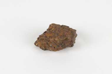
 The Beechworth Burke Museum
Geological specimen - Feldspathic Sandstone
Feldspathic arenites are sandstones that contain less than 90% quartz, and more feldspar than unstable lithic fragments, and minor accessory minerals.Feldspathic sandstones are commonly immature or sub-mature.These sandstones occur in association with cratonic or stable shelf settings. Feldspathic sandstones are derived from granitic-type, primary crystalline, rocks. If the sandstone is dominantly plagioclase, then it is igneous in origin Sandstone features prominently in public buildings throughout Victoria. Most of the sandstone used as dimension stone in the State came from three sources: the Heatherlie quarry in the Grampians (Silurian), the Bacchus Marsh area (Permian), and the Barrabool Hills near Geelong (Cretaceous).Sandstone features prominently in public buildings throughout Victoria, making this specimen special as it shows the materials used by Victorian building companies. Sandstone can also be crushed, crushed stone is used in the construction of roadways and road structures such as bridges, and in buildings, both commercial and residential. This specimen is part of a larger collection of geological and mineral specimens collected from around Australia (and some parts of the world) and donated to the Burke Museum between 1868-1880. A large percentage of these specimens were collected in Victoria as part of the Geological Survey of Victoria that begun in 1852 (in response to the Gold Rush) to study and map the geology of Victoria. Collecting geological specimens was an important part of mapping and understanding the scientific makeup of the earth. Many of these specimens were sent to research and collecting organisations across Australia, including the Burke Museum, to educate and encourage further study. A feldspar-rich sandstone, a sandstone intermediate in composition between an arkosic sandstone and a quartz sandstone, containing 10% to 25% feldspar and less than 20% matrix material of clay, sericite, and chlorite. Feldspathic arenite containing less than 90 percent of the composition of quartz. Feldspar is the main composition. Feldspathic arenite may contain fragments of unstable rock, and a little amount of other minerals such as mica and heavy minerals. Some feldspathic arenite have pink or red color because of the presence of potassium feldspar or iron oxide. There are also colored light gray to white. These sandstones are usually medium to coarse grained and can contain a high percentage of granules with angular until subangular roundness. The content of the matrix can appear as the rest up to more than 15 percent, and sorting of grains can present as moderate to poorly sorted. Feldspathic sandstones are generally immature in textural maturity. Feldspathic arenite can not be judged from the structure of the sediment. Bedding can emerge from the laminate parallel to the crossbed. Fossils may appear in the layer deposited on the sea. Feldspathic arenites usually appear on the craton or the continental shelf, which can be associated with conglomerate, quartz lithic arenite, carbonate rock, or evaporites. This sandstone may also appear on the succession of sedimentary basins deposited on an unstable or deep sea, and moving arc setting. According to Pettijohn (1963) Arkose make up about 15 percent of all sandstones. Some Arkose formed in situ when the granite and related rocks disintegrate and generate granular sediments. Most of the material feldspathic sandstones derived from primary crystalline granitic rocks, such as granite or metasomatic rocks containing abundant potassium feldspar. Mineral contained in sandstones is mostly a form of plagioclase feldspar derived from quartz diorite or volcanic rock. Feldspar contained on this sandstone comes from arid to cool climates when the chemical weathering process is reduced.sandstone, natural stone, feldspathic sandstone, burke museum, geology, geological, geological specimen -
 The Beechworth Burke Museum
Geological specimen - Laterite
Laterite refers to both a rock and a soil type that is rich in clay, as well as Iron and Aluminium. It is created during a process that is called laterization, where high heat and seasonal heavy rainfall cause there to be wet and dry periods, which over time hardens the soil into rock. Because of this, most laterite is formed between tropics of Cancer and Capricorn. The iron oxide in laterite is what gives it it’s orange-red colouring. The largest religious complex in the world, Angkor Wat in Cambodia, is partially constructed of laterite, particularly its foundations, as laterite is porous and allows rainwater to drain. This specimen of laterite was collected from the Democratic Republic of Congo while it was colonised by Belgium in the 19th century. Laterite forms in many parts of the world, particularly between the tropics. It is used both for ore and as a building material, and comparing specimens from different parts of the world allows us to document the different compositions that this mineral can have when formed at different locations. This specimen is part of a larger collection of geological and mineral specimens collected from around Australia (and some parts of the world) and donated to the Burke Museum between 1868-1880. A large percentage of these specimens were collected in Victoria as part of the Geological Survey of Victoria that begun in 1852 (in response to the Gold Rush) to study and map the geology of Victoria. Collecting geological specimens was an important part of mapping and understanding the scientific makeup of the earth. Many of these specimens were sent to research and collecting organisations across Australia, including the Burke Museum, to educate and encourage further study.a palm-sized solid iron-aluminium oxide mineral specimen in shades of brown, orange and greyburke museum, beechworth, geological, geological specimen, laterite, laterite specimen, geology -
 Marysville & District Historical Society
Photograph (Item) - Black and white photograph, Nicholas John Caire, c1880-1884
A copy of an early black and white photograph of Murchison Street in Marysville in Victoria taken by Nicholas John Caire.A copy of an early black and white photograph of Murchison Street in Marysville in Victoria taken by Nicholas John Caire. Murchison Street was named for Roderick Impey Murchison who was one of the most distinguished geologists of the 19th century. His liberality and social position plus the pride he took in his science were of immense value in furthering the cause of learning in Britain. Nicholas John Caire was born in 1837 in Guernsey. He arrived in Adelaide about 1860 along with his parents who encouraged his early interest in photography. He opened a studio in Adelaide in 1867 after traveling extensively throughout the Gippsland taking photographs. After marrying in 1870 he moved to Talbot in Victoria until 1876 when he opened a studio in the Royal Arcade in Melbourne. After 1885 Nicholas John Caire gave up his city work and made his home in South Yarra and devoted the rest of his life to outdoor photography, specializing in the bush, the gullies, and the mountains of south-eastern Victoria. LES HARSANT/ HEALESVILLE Entrance to Marysville/ from Nicholas Caire photo - c.1880-84 See Pitkethly, N.J. Caire, Landscape Photographer Pithkethly, Rosanna, Vic. 1988; plate 17murchison street, marysville, victoria, nicholas john caire, roderick impey murchison, geology, geologist -
 Phillip Island and District Historical Society Inc.
Photograph
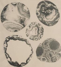
One of a collection of over 400 photographs in an album commenced in 1960 and presented to the Phillip Island & Westernport Historical Society by the Shire of Phillip IslandPhotograph of five polished surfaces of Amygdales from Pyramid Rock. Enlarged by four times.local history, photography, polished amygdales, black & white photograph, geology, john jenner, bryant west -
 Federation University Historical Collection
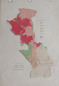
Plan, Parish of Lal-Lal County of Grant
Printed colour map on paperlal lal, mt doran, lal lal racecourse, geology, geological, moorabool river, mount duran -
 Federation University Historical Collection
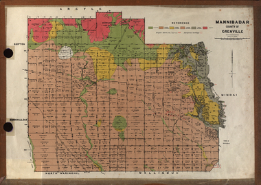
Plan, Mannibadar Geological plan
Coloured plan of Mannibadar, County of Grenville.mannibadar, pitfield, mount bute, emu hills, woady yalouk river, geology, plan -
Federation University Historical Collection
Book, A text-book of Euclid's elements: for the use of schools, 1894
Owned by William Baragwanath who studied at Schools of Mines Ballarat. He became council member of the school of mines from 1916-50. William Baragwanath (1878-1966), surveyor, geologist and public servant, was born on 1 August 1878 at Durham Lead near Ballarat, Victoria.Worn, maroon cloth bound book with gold printing on the spine. It is illustrated and is 430 pages long.In pen inside leaf - W. Baragwanath, SMB (crossed out), School of Mines, Ballarat Vic In pen on title page - Series of numbers and [illegible] be able to quote any by number. Inside in pencil and pen - various drawings and numbers.william baragwanath, a text book of euclid's elements, h s hall, f h stevens, school of mines ballarat, geology, mathemathics -
 Ballarat Heritage Services
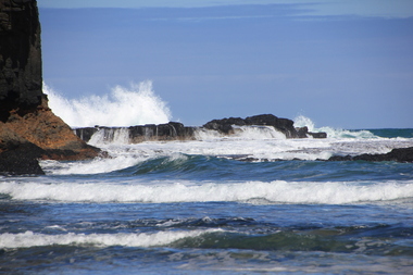
Digital photographs, L.J. Gervasoni, Bushrangers Bay, 2016
coast, coastal, coastal geomorphology, geology, ocean, waves, bushrangers bay