Showing 4547 items matching "historical maps"
-
 Marysville & District Historical Society
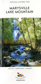
Map (Item) - Tourist map, Mystic Mountains Tourism, OFFICIAL VISITORS' MAP MARYSVILLE LAKE MOUNTAIN, Unknown
A visitors' map of Marysville and Lake Mountain produced by Mystic Mountains Tourism for Visit Victoria.A visitors' map of Marysville and Lake Mountain produced by Mystic Mountains Tourism for Visit Victoria.The Marysville and Lake Mountain Visitor Map and Touring Guide has been compiled and/ published by Mystic Mountains Tourism Inc. Copyright./ Production and artwork Graph Attack P/Lmarysville, lake mountain, victoria, australia, visitor's map, official visitors' map marysville lake mountain, buxton, narbethong, taggerty, visit victoria, mystic mountains tourism inc, graph attack p/l, mystic mountains, marysville triangle, marysville visitor information centre, marylands country house, black spur, steavenson falls, lady talbot drive, cambarville, cathedral ranges, wirreanda festival, lake mountain summit walk, summit walk loop, leadbeaters loop, day loop walk, buxton hotel, igloo roadhouse, karmann waters, silverstream b&b cottages, buxton trout and salmon farm, the niche wine bar, buxton post office & general store, choppers buxton roadhouse, woodlands rainforest bungalows, chestnut glade, black spur inn, wombat cottage, abbey lake luxury b&b spa cottages, mystic mountain ski hire & outdoors, pnl 4wdriving, blue views holiday units & ski hire, marapana agistment park & farm stay b&b, danico design, things of sand & stone, mantirri blueberry farm, allawah country cottages, amberview cottages, ashlar cottage b&b, black spur motel & caravan park, blackwood deluxe cottages, blackwood courtyard b&b, dalrymples guest cottages, delderfield, el kanah guest house, fruit salad farm, kerami guest house, keppels hotel, lake mountain-snow gum lodge, lomatia lodge, lyell guest cottages, magnolia house, keppel waters, lyrebird apartments, marysville caravan park, all view spa apartments, riverside cottages, maryton park b&b country cottages, melina cottage, mountain lodge, mystic mountains holiday cottages, nanda binya lodge, rendezvous luxury cottages, scenic b&b motel, the cumberland, south cathedral farm, tower motel, willowbank at taggerty, woodlands rainforest retreat, marysville & district country club inc, mystic mountains ski hire & outdoors, rubicon valley horse riding, marysville trout and salmon ponds, gallipoli park, keppels lookout, cambarville-yarra ranges national park, lake mountain-yarra ranges national park, lady talbot drive-yarra ranges national park, cathedral range state park, steavenson river, taggerty river, acheron river, lake mountain alpine resort, bruno's art and sculpture garden, manical mechanicals, uncle fred & aunty val's old style lolly shop, carmyle farm boutique, crossways historic country inn, fraga's, gilberts restaurant, heights licensed bistro, the old woolshed cafe, cathedral view natural therapies, crystal journey -
 Marysville & District Historical Society
Photograph (Item) - Colour photograph, Unknown
A digital copy of a colour photograph of The Corner Cupboard Cafe in Marysville in Victoria.A digital copy of a colour photograph of The Corner Cupboard Cafe in Marysville in Victoria. This building, along with most of the other buildings in Marysville, was destroyed in the 2009 Black Saturday bushfires.the corner cupboard cafe, marysville, victoria, photograph, 2009 black saturday bushfires -
 Marysville & District Historical Society
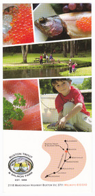
Ephemera (Item) - Advertising brochure, Buxton Trout & Salmon Farm, Unknown
An advertising brochure for Buxton Trout and Salmon Farm in Victoria.An advertising brochure for Buxton Trout and Salmon Farm in Victoria. Buxton Trout and Salmon Farm was established in 1958 and is Australia's first commercial trout farm where trout have been reared for over 50 years.buxton, victoria, buxton trout and salmon farm, advertising brochure, brochure, trout, salmon -
 Marysville & District Historical Society
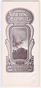
Map (Item) - Tourist Map, Tourists Resorts' Committee, Tourist's Map of Healesville Marysville and Warburton Districts, 13.10.1925
A tourist map for Healesville, Marysville and Warburton that was produced by the Tourists Resorts' Committee. This map was produced in 1925.A tourist map for Healesville, Marysville and Warburton that was produced by the Tourists Resorts' Committee.Photo Lithographed at the Department of Lands and Survey, Melbourne by W.J. Butson./ 13.10.25healesville, marysville, warburton, victoria, tourists resorts' committee, ben cairn, mount donna buang, the black's spur, the acheron valley, narbethong, launching place, tourist information, tourism, map, tourist map -
 Marysville & District Historical Society
Map (Item) - Tourist Map, Department of Lands & Survey, Tourist's Map of Narbethong and Marysville Districts Victoria, 1913
A tourist map for the Narbethong and Marysville Districts that was originally produced by the Department of Lands & Survey in 1925.A tourist map for the Narbethong and Marysville Districts that was originally produced by the Department of Lands & Survey in 1925.Reprint of the 1925 Tourist brochure by permission R.E. Holmes Surveyor General By Authority: ALBERT J. MULLETT, Government Printer, Melbourne. Photo Lithographed at the Department of Lands and Survey Melbourne by W.J. Butson/ 26.8.13narbethong, marysville, victoria, department of lands & survey, the acheron valley, warburton, map, tourist map -
 Wycheproof & District Historical Society Inc.
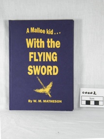
book, W.M. Matheson, A Mallee kid with the Flying Sword, 2004 (exact)
W.M. Matheson 409169 F/LT who lives at Wycheproof, relates his wartime experiences as a Flying Officer - William "Murdoch" Matheson made 194 operational flights and his accounts of missions and descriptions of different locations are interesting.An autobiographical account of service with the Royal Auxiliary Air Force in World War II. A hard covered blue book with gold inscription. Contents describe the author's overseas service in World War II. Two final chapters are the End of the War and Reflections. The Wycheproof Historical Society/With Best Wishes/Murdoch/409169 F/LT MATHESON WILLIAM MURDOCHno 601 county of london squadron, royal auxiliary air force, 1939 war, murdoch matheson, pilots foggia italy photo, italian war map, end of, the war 1945 -
 Wycheproof & District Historical Society Inc.
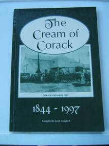
Book - Book, paperback, The Cream of Corack 1844-1997, 1977
Useful reference listed for further reading and research e.g.page 11. Many Corack names and almost all people in the group photos are named. Effectively relates to social and enviromental themes in local history that led to closed rural schools with the drift and decline in population.Green and cream cover A4 size 94 page book - a record of the Corack district with photographs and town map blocks featuring owners.Topics covered include,churches,sports,community organisations and buildings,mail runs,rabbits,war memorial, water,Lake Buloke,Corack Station.Top of introductory page:handwritten text-"Donated to the Wycheproof Historical Society by Mick Giddings of 'Willandra' Museum."corack, local history -
 Wycheproof & District Historical Society Inc.
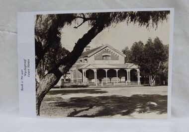
Photograph, Wycheproof Court House, (estimated); mid to late 19th century
The Court House opened as a court of petty sessions in 1890 and closed as a court in the early 1980s. It is now a 'Place of Deposit' for paper based products, maps, documents and photographs, and the home of the Wycheproof and District Historical Society Inc. The local Craft Group met at the Court House between 1982 and 2010. The Buloke Shire Council oversees the maintenance of the building.The Court House is No H 1656 on the Victorian Heritage Register. It is the one of only two buildings with this listing in Wycheproof, and characteristic of the type of building constructed in the early days of settlement in Wycheproof. The architecture is of aesthetic value and although some restoration work has taken place to maintain the structure, it remains in good condition and with some of the original furnishings intact.Sepia print of the Wycheproof-Court-House. It was constructed during 1889/90 and commissioned on September 23,1890 as a court-of-petty-sessions. A simple form of Court House built of red-face-brick but embellished by stepped brick work in the principal gable and by the traverse veranda with elaborate frieze and gabled pavilions that protect the street facade. The roof is of slate.Nonecourt house, wycheproof heritage 1890, petty sessions, building, red face brick, gabled pavilions -
 Wycheproof & District Historical Society Inc.
Bunguluke Map, Bunguluke District In 1923, 27.2.1923
By 1881 Bunguluke was a small settlement as recorded, December 5, in the Charlton "Mercury". It reports that in that year Draper's Store, Hotel and Post Office and residence at Bunguluke North was totally destroyed by fire. For years now there has been little sign of community life with houses few and far between and acreages have gone into larger holdings. The map references land blocks and owners for that era.This important map shows the local land ownership and local features that existed in 1923. This is a photocopied black and white map of Bunguluke in the County of Kara Kara, Number L5149. Marked - Photo Lithographed by W.J. Butson 27.2.1923. The details include numbers of allotments, property owners, roads, rivers. The boundaries marked are the Parish of Jeruk, Parish of Wycheproof, Parish of Cooroopajerrup. Wycheproof township location is shown with the Scale of Chains. Bunguluke maps for other years are also in the collection.map, bunguluke, jeruk, wycheproof, cooroopajerrup -
 Wycheproof & District Historical Society Inc.
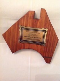
Memorabilia - Plaque, award, 2012
Wycheproof Historical Society in November 2010 co- ordinated and hosted the re- opening of the refurbished Wycheproof Station to great acclaim. The re-opening of the railway station provided a focus on the railway heritage of Wycheproof bringing former railway workers and was supported by Steam Rail Victoria which re-scheduled a train to visit a Wycheproof on the day.wycheproof is a railway town and its major contribution is recognised Varnished brown hardwood map of Australia with rectangular bronze plaque inscription in black lettering.AUSTRALIA DAY AWARD 2012 WYCHEPROOF EVENT OF THE YEAR HISTORICAL SOCIETY. PRESENTED BY WYCHEPROOF VISION SPONSORED BY LIONS CLUB OF WYCHEPROOF.wycheproof vision, lions club, australia day, 2012 -
 Flagstaff Hill Maritime Museum and Village
Document - Map, Department of Lands & Survey, Victoria / Panmure, 1942
This Emergency Edition of the map of Panmure, Victoria, is part of the W.R. Angus Collection. It was printed in 1942 during World War II. It is one of two maps donated to Flagstaff Hill Maritime Village by the family of Doctor William Roy Angus, who served as Surgeon Captain in the Australian Defence Department. The map was compiled for the Dept. of Army by the Dept. of Lands and Survey in Melbourne, prepared by the Australian Section of the Imperial General Staff, which was a British Government body created in 1907 to co-ordinate the defence of Britain and its Empire. It was printed by A.H.Q. Cartographic Company, Survey Corps, which was formed in 1941. The Corp changed its name to L.H.Q. Cartographic Company of Bendigo. In 1947 the name reverted back to the A.H.Q. Cartographic Company until 1955 when it became the A.H.Q. Survey Regiment. The W.R. Angus Collection includes historical medical equipment, surgical instruments and material once belonging to Dr Edward Ryan and Dr Thomas Francis Ryan, (both of Nhill, Victoria) as well as Dr Angus’ own belongings. The Collection’s history spans the medical practices of the two Doctors Ryan, from 1885-1926 plus that of Dr Angus who began practice in 1924. Dr. Angus served with the Australian Department of Defence as a Surgeon Captain during the Second World Was from 1942 to 1945. He served in Ballarat, Victoria, and in Bonegilla, N.S.W. until he suffering from a heart attack just before the war ended. ABOUT THE “W.R.ANGUS COLLECTION” - Doctor William Roy Angus M.B., B.S., Adel., 1923, F.R.C.S. Edin.,1928, was generally known as Dr Roy Angus. His working life included a position as a doctor with the Flying Doctor Service in Australia’s rural and remote areas. After many varied experiences Dr Angus and his family moved to Warrnambool in 1939 where he purchased “Birchwood,” the 1852 home and medical practice of Dr John Hunter Henderson. He was appointed on a part-time basis as Port Medical Officer in Warrnambool and held this position until the 1940’s when the government no longer required the service of a Port Medical Officer. Dr Angus was a surgeon at the Warrnambool Base Hospital 1939-1942. After further studies he commenced practice as an ophthalmologist in Warrnambool, pioneering in artificial eye improvements. He was Honorary Consultant Ophthalmologist to Warrnambool Base Hospital for 31 years and made monthly visits to Portland to perform eye surgery. Dr Angus and his wife Gladys were very involved in Warrnambool’s community with a strong interest in civic affairs. They were both involved in the creation of Flagstaff Hill Maritime Village, including the layout of the gardens. After his death on 28th March 1970 his family requested his practitioner’s plate, medical instruments and some personal belongings be displayed in the Port Medical Office surgery at Flagstaff Hill Maritime Village, and be called the “W. R. Angus Collection”. This Emergency Edition of the Map of Panmure is significant as an example of the documents prepared for the defence of Australia in World War 2. The Map is also significant for its connection between the Australian Army and the involvement of Dr WR Angus as a Surgeon in the Medical Services during World War II. The W.R. Angus Collection is significant for still being located at the site it is connected with, Doctor Angus being the last Port Medical Officer in Warrnambool. The collection of medical instruments and other equipment is culturally significant, being an historical example of medicine, administration, household equipment and clothing from late 19th to mid-20th century. Dr Angus assisted Dr Tom Ryan, a pioneer in the use of X-rays and in ocular surgery. The collection includes Dr Angus’s Army objects and is significant as an example of items issued to Doctors and Surgeons in the Medical Services of the Australian Army in World War IIMilitary map of Panmure, Victoria, Australia; part of the W.R. Angus Collection. Rectangular coloured map on cream paper for the Australian Army. Details include sea, waterways and land, contour lines, grid lines, names of districts, towns and roads, bridges, swamps, rail lines, cuttings, tracks, buildings (including blacksmiths), pumps, lighthouses, telegraph, telephones and electric transmission lines, and fire stations. The map has margin notes that include distances in miles to nearby towns. The map was compiled for the Dept. of Army by the Dept. of Lands and Survey in Melbourne, prepared by the Australian Section, Imperial General Staff and printed by A.H.Q. Cartographic Company, Melbourne in 1942. Crown Copyright Reserved. Inscriptions in red print state that it is and Emergency Edition and an Official document. An oval purple stamp includes the price.Printed in black; 'Victoria / Panmure", "No. 930 / Zone 6" Printed in red; “EMERGENCY EDITION”, “THIS MAP IS AN OFFICIAL DOCUMENT. IF FOUND, IT MUST BE HANDED / IN TO THE NEAREST MILITARY HEADQUARTERS OR POLICE STATION” Stamped: within concentric ovals (“- - - FOR SALE / PRICE 2/- / - - - - - OF THE ARMY”)flagstaff hill, warrnambool, flagstaff hill maritime museum, maritime museum, shipwreck coast, flagstaff hill maritime village, great ocean road, dr w r angus, dr ryan, warrnambool base hospital, flying doctor, surgeon captain, australian department of defence, royal australian army, world war 2, map panmure 1942, roy angus, port medical officer, nhill base hospital, military map, emergency map, military service australian army, department of army, department of lands and survey, a.h.q. cartographic company melbourne, panmure 1942, australian section, imperial general staff -
 Flagstaff Hill Maritime Museum and Village
Document - Map, Department of Lands & Survey, Victoria / Port Campbell, 1942
This Emergency Edition of the map of Port Campbell, Victoria, is part of the W.R. Angus Collection. It was printed in 1942 during World War II. It is one of two maps donated to Flagstaff Hill Maritime Village by the family of Doctor William Roy Angus, who served as Surgeon Captain in the Australian Defence Department. The map was compiled for the Dept. of Army by the Dept. of Lands and Survey in Melbourne, prepared by the Australian Section of the Imperial General Staff, which was a British Government body created in 1907 to co-ordinate the defence of Britain and its Empire. It was printed by A.H.Q. Cartographic Company, Survey Corps, which was formed in 1941. The Corp changed its name to L.H.Q. Cartographic Company of Bendigo. In 1947 the name reverted back to the A.H.Q. Cartographic Company until 1955 when it became the A.H.Q. Survey Regiment. The W.R. Angus Collection includes historical medical equipment, surgical instruments and material once belonging to Dr Edward Ryan and Dr Thomas Francis Ryan, (both of Nhill, Victoria) as well as Dr Angus’ own belongings. The Collection’s history spans the medical practices of the two Doctors Ryan, from 1885-1926 plus that of Dr Angus who began practice in 1924. Dr Angus served with the Australian Department of Defence as a Surgeon Captain during the Second World Was from 1942 to 1945. He served in Ballarat, Victoria, and in Bonegilla, N.S.W. until he suffering from a heart attack just before the war ended. ABOUT THE “W.R.ANGUS COLLECTION” - Doctor William Roy Angus M.B., B.S., Adel., 1923, F.R.C.S. Edin.,1928, was generally known as Dr Roy Angus. His working life included a position as a doctor with the Flying Doctor Service in Australia’s rural and remote areas. After many varied experiences Dr Angus and his family moved to Warrnambool in 1939 where he purchased “Birchwood,” the 1852 home and medical practice of Dr John Hunter Henderson. He was appointed on a part-time basis as Port Medical Officer in Warrnambool and held this position until the 1940’s when the government no longer required the service of a Port Medical Officer. Dr Angus was a surgeon at the Warrnambool Base Hospital 1939-1942. After further studies he commenced practice as an ophthalmologist in Warrnambool, pioneering in artificial eye improvements. He was Honorary Consultant Ophthalmologist to Warrnambool Base Hospital for 31 years and made monthly visits to Portland to perform eye surgery. Dr Angus and his wife Gladys were very involved in Warrnambool’s community with a strong interest in civic affairs. They were both involved in the creation of Flagstaff Hill Maritime Village, including the layout of the gardens. After his death on 28th March 1970 his family requested his practitioner’s plate, medical instruments and some personal belongings be displayed in the Port Medical Office surgery at Flagstaff Hill Maritime Village, and be called the “W. R. Angus Collection”. This Emergency Edition of the Map of Port Campbell is significant as an example of the documents prepared for the defence of Australia in World War 2. The Map is also significant for its connection between the Australian Army and the involvement of Dr WR Angus as a Surgeon in the Medical Services during World War II. The W.R. Angus Collection is significant for still being located at the site it is connected with, Doctor Angus being the last Port Medical Officer in Warrnambool. The collection of medical instruments and other equipment is culturally significant, being an historical example of medicine, administration, household equipment and clothing from late 19th to mid-20th century. Dr Angus assisted Dr Tom Ryan, a pioneer in the use of X-rays and in ocular surgery. The collection includes Dr Angus’s Army objects and is significant as an example of items issued to Doctors and Surgeons in the Medical Services of the Australian Army in World War IIMilitary map of Port Campbell, Victoria, Australia; part of the W.R. Angus Collection. Rectangular coloured map on cream paper for the Australian Army. Details include sea, waterways and land, contour lines, grid lines, names of districts, towns and roads, bridges, swamps, rail lines, cuttings, tracks, buildings (including blacksmiths), pumps, lighthouses, telegraph, telephones and electric transmission lines, and fire stations. The map has margin notes that include distances in miles to nearby towns. The map was compiled for the Dept. of Army by the Dept. of Lands and Survey in Melbourne, prepared by the Australian Section, Imperial General Staff and printed by A.H.Q. Cartographic Company, Melbourne in 1942. Crown Copyright Reserved. Inscriptions in red print state that it is and Emergency Edition and an Official document. An oval purple stamp includes the price.Printed in black; 'Victoria / Port Campbell", "No. 932 / Zone 6" Printed in red; “EMERGENCY EDITION”, “THIS MAP IS AN OFFICIAL DOCUMENT. IF FOUND, IT MUST BE HANDED / IN TO THE NEAREST MILITARY HEADQUARTERS OR POLICE STATION” Stamped: within concentric ovals (“- - - FOR SALE / PRICE 2/- / - - - - - OF THE ARMY”)flagstaff hill, warrnambool, flagstaff hill maritime museum, maritime museum, shipwreck coast, flagstaff hill maritime village, great ocean road, dr w r angus, dr ryan, warrnambool base hospital, nhill base hospital, flying doctor, surgeon captain, map port campbell 1942, roy angus, port medical officer, military map, emergency map, australian department of defence, royal australian army, military service australian army, department of army, department of lands and survey, world war 2, a.h.q. cartographic company melbourne, australian section, imperial general staff, port campbell 1942 -
 Phillip Island and District Historical Society Inc.
Book, Western Port chronology 1798-1839 : exploration to settlement, 1984
Extracts from log books and journals of explorers and travellers from the time George Bass entered and sketched the harbour in 1798, combined with rare charts and plates. This compilation brings life to European activity at Western Port during the thirty-seven years that preceded Melbourne's founding. xiv, 110 p. : ill., facsims., maps ; 24 cm. ISBN 0959065202 -
 Phillip Island and District Historical Society Inc.
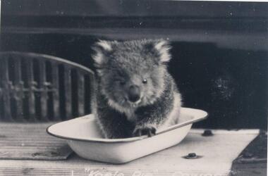
Photographs, Kodak, Early 20th Century to mid 20th Century
A collection of a group of photographs donated to the Society by Lun Blom, from the Photo Shop in Thompson Avenue, Cowes (was opposite the museum)A collection of 19 photographs of Phillip Island and surrounds. 293-01. Koala sitting in enamel bowl on table 293-02. 20 farmers having a break. 293-03. Reproduction of painting of The Nobbies. 293-04. Photograph of a Trophy for 1st prize for ploughing won by Mr L Morrison 1859. 293-05. Photograph of three men standing in front of a motor vehicle. 293-06. Photograph of view of Cleeland's House at Cape Woolamai. 293-07. Photograph of a whale beached on Phillip Island with people standing around it. 293-08. Photograph of a family and children in front of car - unknown. 293-09. Photograph of a painting of "Innishowen" Harbison's Property. Mr Harbison's portrait inset on the painting. 293-10. Photograph of an early map - possibly drawn by Bass & Flinders. 293-11. Photograph of the San Remo-Westernport Hotel, with vehicles in front. 293-12. Photograph of a fishing boat at the San Remo Jetty with the township in the background. 293-13. Photograph of a couta boat under full sail in Westernport. 293-14. Photograph of an aerial view of the Two Bridges taken from San Remo side. 293-15. Photograph of the Mutton Bird Eggers Camp - Bergins Bay Cape Woolamai. 293-16. Photograph of a Steam ferry decorated with flags. 293-17. Photograph of Fisherman's hut at Cowes with pier in the background. Possibly Mr Cox's. 293-18. Photograph of a couple standing on the bridge in Lover's Walk Cowes. 293-19. Photograph of an aerial view of Phillip Island looking towards Mornington Peninsula and the Heads to Port Phillip Bay in the distance.293-01. "Koala Pie" Cowes. 293-06. Mr Cleeland's Station. 293-09. "Innishowen" Mr. Harbison. 293-10. Phillip Island. 293-17. Phillip Island - Fisherman's Hut, Cowes. 293-18. Phillip Island - Lover's Walk, Cowes.wildlife - koala, wildlife - whale, the nobbies, ploughing trophy, cape woolamai - cleeland's house, innishowen, mr harbison, phillip island map, westernport hotel san remo, fishing boat san remo pier, couta boat westernport, the two bridges san remo, mutton bird eggers camp, steam ferry, fisherman's hut cowes, lover's walk cowes, aerial view of phillip island, lyn blom -
 Phillip Island and District Historical Society Inc.
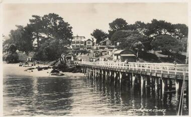
Photographs-Postcards, Valentine Publishing Co. Pty. Ltd. et al, 1940's
Five of a collection of 12 photographs and postcards donated by Jill Palmer.Five black & white postcards taken around Phillip Island. 357-08: Looking from the Cowes Pier towards the Isle of Wight Hotel. Shows camel rides on the beach. 357-09: Bayview Guest House on The Esplanade, Cowes. 357-10: A koala and young on tree. 357-11: Penguins coming in at dusk at the Penguin Parade. 357-12: Broadbent's Official Map of Phillip Island.357-08: The Pier, Cowes. No. 9. 357-09: Photo Shop Series. Bayview Guest House. Cowes. 357-10: Native Bears (Koala) at Cowes No. 55B. 357-11: Photo Shop Series. Parade of the Penguins. Phillip Island. 357-12: Broadbent's Official Map. Phillip Island.cowes pier, cowes beach, wildlife - koalas, wildlife - penguins, bayview guest house cowes phillip island, map of phillip island -
 Phillip Island and District Historical Society Inc.
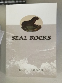
book, Ruth Gooch, Seal Rocks and Victoria's primitive beginnings, 2008
ix, 166 p. : ill., maps, ports. ; 25 cm. Includes index. Bibliography: p. 151-159. Stamped Phillip Island & District Historical Societyseal rocks, local aboriginal history, sealing, western port -
 Phillip Island and District Historical Society Inc.
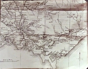
Photograph, Rail Lines of Victoria, Early to mid 20th century
Map showing extensive railway network in Victoria in early C20th.Sepia photo of map of Victoria showing rivers and railway lines and stations.Names of towns, rivers, bays etcsepia photograph, rail transport, victoria, map -
 Phillip Island and District Historical Society Inc.
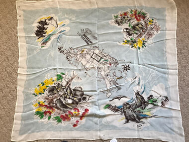
Scarf, Scarf with Map, flowers and animals of Phillip Island, c 1950's
Scarf possibly owned by Alice Robinson (nee Clark)Nylon scarf with map, flowers and animals of Phillip Island.Phillip Island and names of towns and places of interest.souvenir scarf, alice robinson -
 Phillip Island and District Historical Society Inc.
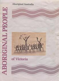
book, Aboriginal people of Victoria, 1990
15 p. : ill. (some col.), map, ports. ; 30 cm. Cover title. Cat. no. 8907893. Bibliography: p. 15. ISBN 0644101547Stamped: Phillip Island & District Historical Societyrichard broome, aboriginal people of victoria, aboriginal australia. culture and society, aboriginal australians -- australia -- victoria., aboriginal and torres strait islander commission -
 Phillip Island and District Historical Society Inc.
Photographs, Early 20th Century
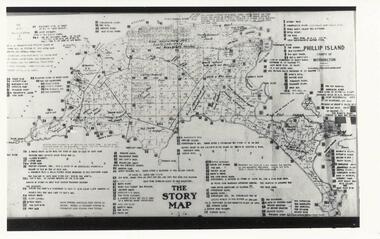
Three photographs/postcards donated by J Gliddon234-01. Black & White photograph of The Story Map of Phillip Island with allotments shown and extremely detailed information typed on it by Vernon McHaffie. 234-02. Sepia postcard of the penguin rookery on "Little Nobby", Phillip Island. Man sitting on hill looking down at the rookery showing tracks & entrances to burrows. 234-03. Sepia postcard of two people sitting on top of cliff, Headland Rookery, with moulting penguins on their laps. 234-02. "Tom Tregellas" Nature Series No. 1. (Penguins) Phillip Island. Rookery on Little Nobby, showing tracks and entrances to burrows amongst the "pig-face" weed. 234-03. "Tom Tregellas" Nature Series No. 1. (Penguins) Phillip Island. Moulting Burrow on top of Cliff, Headland Rookery, which contained four birds. Note feathers outside burrow.phillip island map, phillip island allotments, vernon mchaffie, wildlife - penguins, penguins phillip island, penguin rookeries phillip island, j gliddon -
Phillip Island and District Historical Society Inc.
Book, Aboriginal string bags : nets and cordage, 1999
xv, 157 p. : ill., maps ; 24 cm. Occasional papers, Anthropology and History ; To The Phillip Island and District Historical Society, With best wishes, Alan West, July 2001fibers, string craft, australia, rope, aboriginal australians, industries -
Phillip Island and District Historical Society Inc.
Book, Aboriginal string bags : nets and cordage, 1999
xv, 157 p. : ill., maps ; 24 cm. Occasional papers, Anthropology and History ; Inscribed 'To Phillip Island & District Historical Society with best wishes from Alan West, January 2000'.fibers, string craft, australia, rope, aboriginal australians, industries -
Phillip Island and District Historical Society Inc.
Book, Broadbent's Official Road Guides Company, Broadbent's official guide : Gippsland and south-east corner of N.S.W. incorporating large scale maps, 1950
J.P. Anderson, 97 Salmon St., Hastings'victoria, guidebooks -
Phillip Island and District Historical Society Inc.
Book, Chambers, Chambers's encyclopaedia : a dictionary of universal knowledge for the people, illustrated with maps and numerous wood engravings, 1862
Museum holds v.4. Elephant to Gongora. Stamped 'Phillip Island & District Historical Society'. -
Phillip Island and District Historical Society Inc.
Book, WELLS, John, Colourful tales of old Gippsland, 1990
Maps on endpapers. First published Rigby, 1977. Includes bibliographical references.gippsland, history -
Phillip Island and District Historical Society Inc.
Book, William Collins, library atlas : consisting of one hundred and ten maps of modern, historical, and classical geography, &c., with descriptive letterpress of Modern geography by James Bryce, Historical geography by William F. Collier, Classical geography by Leonard Schmitz; with copious indices, 1876?
... library atlas : consisting of one hundred and ten maps of... : consisting of one hundred and ten maps of modern, historical ...Inscribed: Hazel Fair, 37 Laura St., E. Bruns. N. 10. Stamped: J.R. Mann, Bookseller, Victoria Market ; Phillip Island & District Historical Society -
Phillip Island and District Historical Society Inc.
Book, RMIT Cartography, Phillip Island : historical map series, 1991
... Phillip Island : historical map series... Historical Society'. Phillip Island : historical map series Book RMIT ...Stamped 'Phillip Island & District Historical Society'. -
Phillip Island and District Historical Society Inc.
Book, LOVE, Don, Shipwrecks on the South Gippsland Coast, 2005
Maps on endpapers. Includes bibliographical references and indexes.shipwrecks, victoria, south gippsland, history -
Phillip Island and District Historical Society Inc.
Book, F.E. Hiscocks &? Co, F.E. Hiscocks &? Co.'s new Victorian counties atlas, 1874 [cartographic material] : together with map of Victoria, indicating roads, distances, relative position of counties, &?c, 1874
Labelled 'Cowes Free Public Library', 'Phillip Island Historical Society, Cleeland Bequest'.victoria, maps -
Phillip Island and District Historical Society Inc.
Book, Whitehead, Whitehead's new map of Victoria with alphabetical key 1867-8, 1868