Showing 2317 items matching "infrastructure"
-
 Melbourne Water
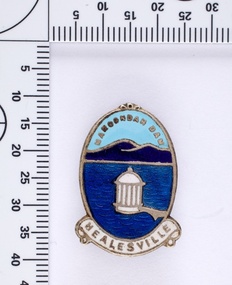
Souvenir lapel pin/brooch Maroondah Dam, 1960s/70s
Melbourne Water inherited many of its water assets, such as reservoirs from its predecessor the Melbourne Metropolitan Board of Works (MMBW). They have served the organisation well and have long been celebrated for both their natural beauty and engineering ingenuity. In the nineteenth century Victoria’s fundamental need for water infrastructure went beyond merely functional solutions and reflected the English ideal of the romance and beauty that was embodied in expanses of water. The MMBW further enhanced this notion by incorporating beauty and function in to the Classical and Italianate designs of its infrastructure such as pumping houses and reservoir outlet towers. The reservoir gardens and picnic areas were landscaped with ornamental stonework, exotic trees, decorative flower beds, fern glads pools and rose gardens. All features of the water supply system became widely celebrated as beauty spots that continue to be very popular to this day with tourists and locals alike. This souvenir is a product of that flourishing tourist trade. These water supply sites continue to enhance Melbourne’s charm and liveability and are now recognised as places of cultural and historic significance. This souvenir item has been curated by Melbourne Water as it represents an important historical aspect of the organisation by demonstrating the popularity of its water asset sites as recreational places and tourist attractions, and although these sites are functional parts of the water supply system, they were also designed to be enjoyed by the public both aesthetically and recreationally. Blue enamel and metal lapel pin/brooch depicting Maroondah Reservoir and outlet tower. Oval shaped with words 'Maroondah Dam' at the top and a ribbon banner containing 'Healesville' at the bottom. Maroondah Dam. Healesvillemelbourne metropolitan board of works, mmbw, maroondah reservoir, melbourne water, scenic view, souvenir, lapel pin, brooch -
 Melbourne Water
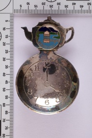
Souvenir tea caddy spoon "Tea Time", Early 1960s
Melbourne Water inherited many of its water assets, such as reservoirs from its predecessor the Melbourne Metropolitan Board of Works (MMBW). They have served the organisation well and have long been celebrated for both their natural beauty and engineering ingenuity. In the nineteenth century Victoria’s fundamental need for water infrastructure went beyond merely functional solutions and reflected the English ideal of the romance and beauty that was embodied in expanses of water. The MMBW further enhanced this notion by incorporating beauty and function in to the Classical and Italianate designs of its infrastructure such as pumping houses and reservoir outlet towers. The reservoir gardens and picnic areas were landscaped with ornamental stonework, exotic trees, decorative flower beds, fern glads pools and rose gardens. All features of the water supply system became widely celebrated as beauty spots that continue to be very popular to this day with tourists and locals alike. This souvenir is a product of that flourishing tourist trade. These water supply sites continue to enhance Melbourne’s charm and liveability and are now recognised as places of cultural and historic significance This souvenir item has been curated by Melbourne Water as it represents an important historical aspect of the organisation by demonstrating the popularity of its water asset sites as recreational places and tourist attractions, and although these sites are functional parts of the water supply system, they were also designed to be enjoyed by the public both aesthetically and recreationally. Tea caddy spoon with clock face engraved showing 4pm on round spoon, tea pot shaped handle with enamel scenic view badge saying 'Healesville' ( depicting Maroondah Reservoir outlet tower). Tea caddy spoon box labelled 'Fine Silverware by Stokes'Stokes and Sons Stokes & Sons logo (Star with S and boomerang) EG. No. 15733melbourne metropolitan board of works, mmbw, maroondah reservoir, melbourne water, scenic view, souvenir, tea caddy spoon -
 Orbost & District Historical Society
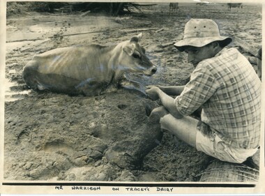
black and white photograph, 11 February 1971
This photograph was taken during the 1971 floods at Orbost. The 1971 flood was the the worst flood on record. At Jarrahmond it was at least 11 metres and up to one and a half kilometres wide on the flats causing enormous damage to the flood plain. Records say that "The brown floodwater stain in Bass Strait could be seen from passing airliners." Considerable damage was done to railway infrastructure, roads and farms. More information from the APRIL, 2008 newsletter by John Phillips. (see orbosthistory.com.au)This is a contemporary pictorial record of a significant local event.A large black / white photograph of a man, dressed in shorts and a checked shirt, sitting on a fence post surrounded by mud. He is holding on to the leg of a cow which is stuck in the mud.on front - "Mr Harrison on Tracey's Dairy" on back - " Herald 11 Feb 1971"floods-orbost-1971 tracey-dairy natural-disaster-flood -
 Nhill Aviation Heritage Centre
Black and white photograph, Local photograph. Original of this scan held by Nhill Historical Society, Aeradio Building c1937
This building is still intact at the Nhill Aerodrome. Some of the infrastructure is also in place or can be evidenced by its foundations.The Aeradio building was built on the present aerodrome in 1937. This was one of only sixteen buildings of this type built across Australia and it housed radio communications and guidance equipment. The building and its equipment were part of a comprehensive system of radio towers, signalling and meteorology equipment aimed at providing safer navigation for aircraft travelling throughout Australia. The facility closed in the 1960sThis photo is significant due to it having been taken soon after the building was constructed. It is the earliest known photograph taken on an open to the public day before the receiver aerials were erected.The Aeradio building was built on the present (2012) aerodrome in 1937 or 1938. This was one of only fifteen buildings of this type built across Australia and it housed radio communications and guidance equipment. The building and its equipment were part of a comprehensive system of radio towers lights and signalling equipment aimed at providing safer navigation for aircraft travelling throughout Australia. The facility closed in the 1960sphoto, aeradio, early, civil aviation, dca, dept of civil aviation -
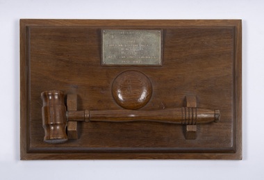 Bacchus Marsh & District Historical Society
Ceremonial object, Presentation Gavel and Sound Block presented to Shire of Bacchus Marsh in Memory of Alec William Bond, 1968
Alec William Bond was Secretary and Engineer for the Shire of Bacchus Marsh from 1924 until his death in 1968. The position of Secretary was similar to a Chief Executive Officer in contemporary terminology. Mr Bond was a prominent figure in the Bacchus Marsh community for nearly 50 years and as Shire Engineer was responsible for the design of a number of local infrastructure projects including the buildings and water scheme at the Lady Northcote Children's Farm at Glenmore and the public swimming pool in Grant Street, A physical memento that recognises the long and notable contributions of an important local government official and their service to the Bacchus Marsh Shire and community.A sound block with a green felt base and inscribed brass plaque with accompanying small hardwood mallet in a cradle.Engraved text on a brass plaque which reads: Presented by May Bond and Family to the Shire of Bacchus Marsh in memory of Alec William Bond Shire Secretary & Engineer 1924 – 1968.alec william bond, bacchus marsh shire council, gavel and sound blocks, local officials and employees, local government -
 Bacchus Marsh & District Historical Society
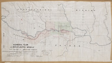
Map, General Plan for Water Supply Works, Shire of Bacchus Marsh 1887
Debate about water supply and its planning and development took place in the Bacchus Marsh region from the 1850s through into the twentieth century. This plan was part of documentation to support an application for an additional loan of money from the Ministry of Water Supply to the Bacchus Marsh Shire Water Supply Trust. The plan includes the route of a proposed water channel in the Parwan area, and other features of water supply infrastructure such as the location of standpipes and gates are also shown on the plan.A single page paper map showing a general plan for the supply of water in the Bacchus Marsh area.The plan shows the route of the 'Main Channel' near the Werribee River and a proposed route for a Parwan Channel. The location of 'Dryden's House' near the Werribee River is also shown and the locations of land held by T. (Tom) Oliver and the Racecourse Reserve in Maddingley. Scale 40 chains to 1 inch. The plan is signed by Bacchus Marsh Shire Engineer, W.E. Standfield. The map is pasted into a bound volume containing 76 maps or plans in total. High resolution digital image stored on BMDHS computer network. General Plan of Water Supply Works in the Shire of Bacchus Marsh. Accompanying application for 2nd additional Loan. Original Waterworks district. Additional area. W.E. Standfield, 30/8/87.water supply, water supply maps, water supply bacchus marsh, irrigation, bacchus marsh victoria maps -
 Eltham District Historical Society Inc
Album - Photograph, J.A. McDonald, General; Strathewan, Feb. 1956
Two dividing fences February 1956Record of various Shire of Eltham infrastructure works undertaken during the period of 1952-1962 involving bridge and road reconstruction projects, sometimes with Eltham Shire Council Project Reference numbers quoted. It was during this period that a number of significant improvements were made to roads and new bridges constructed within the shire that remain in place as of present day (2022). In many situations, the photos provide a tangible visible record of infrastructure that existed throughout the early days of the Shire. The album was put together by or under the direction of the Shire Engineer, J.A. McDonald.infrastructure, shire of eltham, 1956-02, fences, strathewen -
 Eltham District Historical Society Inc
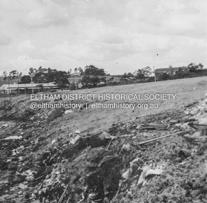
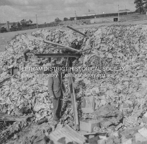
Album - Photograph, J.A. McDonald, General; Camberwell Tip, c. 1956
Showing section of tip and eight feet high face Residential properties in backgroundRecord of various Shire of Eltham infrastructure works undertaken during the period of 1952-1962 involving bridge and road reconstruction projects, sometimes with Eltham Shire Council Project Reference numbers quoted. It was during this period that a number of significant improvements were made to roads and new bridges constructed within the shire that remain in place as of present day (2022). In many situations, the photos provide a tangible visible record of infrastructure that existed throughout the early days of the Shire. The album was put together by or under the direction of the Shire Engineer, J.A. McDonald.infrastructure, shire of eltham, benchmark studies, 1956, camberwell tip -
 Eltham District Historical Society Inc
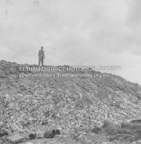
Album - Photograph, J.A. McDonald, General; Camberwell Tip, c. 1956
Showing residential properties at rear Tipping eight feet faceRecord of various Shire of Eltham infrastructure works undertaken during the period of 1952-1962 involving bridge and road reconstruction projects, sometimes with Eltham Shire Council Project Reference numbers quoted. It was during this period that a number of significant improvements were made to roads and new bridges constructed within the shire that remain in place as of present day (2022). In many situations, the photos provide a tangible visible record of infrastructure that existed throughout the early days of the Shire. The album was put together by or under the direction of the Shire Engineer, J.A. McDonald.infrastructure, shire of eltham, benchmark studies, 1956, camberwell tip -
 Eltham District Historical Society Inc
Album - Photograph, J.A. McDonald, General; Camberwell Tip, c. 1956
Showing fifteen feet high face and exposed garbage being covered.Record of various Shire of Eltham infrastructure works undertaken during the period of 1952-1962 involving bridge and road reconstruction projects, sometimes with Eltham Shire Council Project Reference numbers quoted. It was during this period that a number of significant improvements were made to roads and new bridges constructed within the shire that remain in place as of present day (2022). In many situations, the photos provide a tangible visible record of infrastructure that existed throughout the early days of the Shire. The album was put together by or under the direction of the Shire Engineer, J.A. McDonald.infrastructure, shire of eltham, benchmark studies, 1956, camberwell tip -
 Eltham District Historical Society Inc
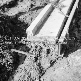
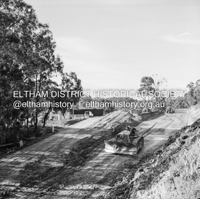
Negative - Photograph, J.A. McDonald, Eltham, Pryor Street, Sep. 1955
Construction of new concrete kerbing and footpath in Pryor Street, Eltham 18” tray and AG backing(?)Record of various Shire of Eltham infrastructure works undertaken during the period of 1952-1962 involving bridge and road reconstruction projects, sometimes with Eltham Shire Council Project Reference numbers quoted. It was during this period that a number of significant improvements were made to roads and new bridges constructed within the shire that remain in place as of present day (2022). In many situations, the photos provide a tangible visible record of infrastructure that existed throughout the early days of the Shire. The album was put together by or under the direction of the Shire Engineer, J.A. McDonald.1955-09, footpaths and gutters, pryor street, infrastructure, shire of eltham -
 Eltham District Historical Society Inc
Negative - Photograph, J.A. McDonald, Eltham-Diamond Creek Road, May 1958
Wing pier Eltham abutment Bridge construction Eltham-Diamond Creek road over the Diamond Creek (Wattletree Road), Eltham, May 1958Record of various Shire of Eltham infrastructure works undertaken during the period of 1952-1962 involving bridge and road reconstruction projects, sometimes with Eltham Shire Council Project Reference numbers quoted. It was during this period that a number of significant improvements were made to roads and new bridges constructed within the shire that remain in place as of present day (2022). In many situations, the photos provide a tangible visible record of infrastructure that existed throughout the early days of the Shire. The album was put together by or under the direction of the Shire Engineer, J.A. McDonald.infrastructure, shire of eltham, 1958-05, bridge construction, wattletree road bridge -
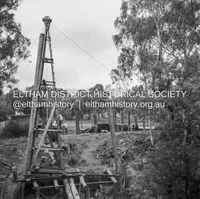 Eltham District Historical Society Inc
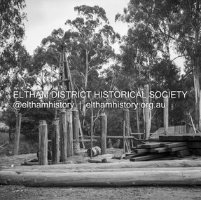
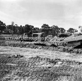
Negative - Photograph, J.A. McDonald, Eltham-Diamond Creek Road, May 1958
Bridge over Diamond Creek Pile driving Diamond Creek pier Bridge construction Eltham-Diamond Creek road over the Diamond Creek (Wattletree Road), Eltham, May 1958Record of various Shire of Eltham infrastructure works undertaken during the period of 1952-1962 involving bridge and road reconstruction projects, sometimes with Eltham Shire Council Project Reference numbers quoted. It was during this period that a number of significant improvements were made to roads and new bridges constructed within the shire that remain in place as of present day (2022). In many situations, the photos provide a tangible visible record of infrastructure that existed throughout the early days of the Shire. The album was put together by or under the direction of the Shire Engineer, J.A. McDonald.infrastructure, shire of eltham, 1958-05, bridge construction, wattletree road bridge -
 Eltham District Historical Society Inc
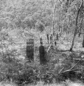
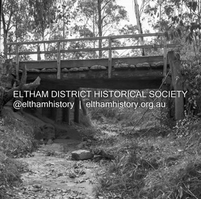
Negative - Photograph, J.A. McDonald, Heidelberg-Kinglake Road, Sep. 1959
Job 56M Contractor Hillgrove Looking downstream under bridge Ironbark Gully September 1959Record of various Shire of Eltham infrastructure works undertaken during the period of 1952-1962 involving bridge and road reconstruction projects, sometimes with Eltham Shire Council Project Reference numbers quoted. It was during this period that a number of significant improvements were made to roads and new bridges constructed within the shire that remain in place as of present day (2022). In many situations, the photos provide a tangible visible record of infrastructure that existed throughout the early days of the Shire. The album was put together by or under the direction of the Shire Engineer, J.A. McDonald.infrastructure, shire of eltham, bridge construction, 1959-09, heidelberg-kinglake road -
 Eltham District Historical Society Inc
Negative - Photograph, J.A. McDonald, Heidelberg-Kinglake Road, Sep. 1959
Job 56M Contractor Hillgrove Ironbark Gully bridge looking south September 1959Record of various Shire of Eltham infrastructure works undertaken during the period of 1952-1962 involving bridge and road reconstruction projects, sometimes with Eltham Shire Council Project Reference numbers quoted. It was during this period that a number of significant improvements were made to roads and new bridges constructed within the shire that remain in place as of present day (2022). In many situations, the photos provide a tangible visible record of infrastructure that existed throughout the early days of the Shire. The album was put together by or under the direction of the Shire Engineer, J.A. McDonald.infrastructure, shire of eltham, bridge construction, 1959-09, heidelberg-kinglake road -
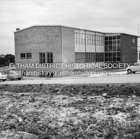
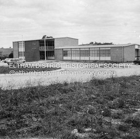
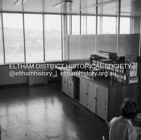
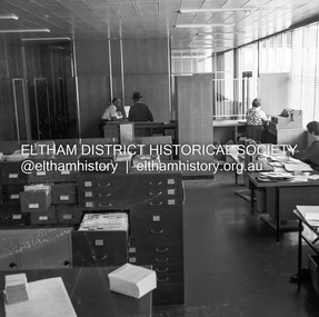
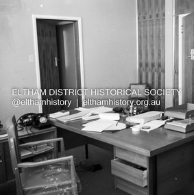
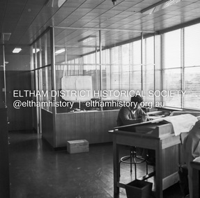
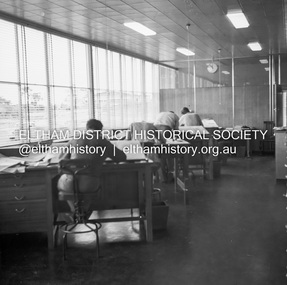
 Eltham District Historical Society Inc
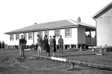
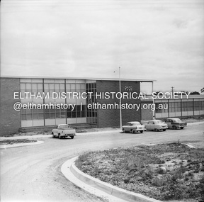
Negative - Photograph, J.A. McDonald, General; Shire Offices, Sep. 1959
Shire of Lilydale, 15 Anderson Street, LilydaleRecord of various Shire of Eltham infrastructure works undertaken during the period of 1952-1962 involving bridge and road reconstruction projects, sometimes with Eltham Shire Council Project Reference numbers quoted. It was during this period that a number of significant improvements were made to roads and new bridges constructed within the shire that remain in place as of present day (2022). In many situations, the photos provide a tangible visible record of infrastructure that existed throughout the early days of the Shire. The album was put together by or under the direction of the Shire Engineer, J.A. McDonald.infrastructure, 1959-09, benchmark studies, lilydale shire office, scan - 120 format 6x6 negative -
 Eltham District Historical Society Inc
Negative - Photograph, J.A. McDonald, General; Shire Offices, 1959
Shire of Lilydale, 15 Anderson Street, LilydaleRecord of various Shire of Eltham infrastructure works undertaken during the period of 1952-1962 involving bridge and road reconstruction projects, sometimes with Eltham Shire Council Project Reference numbers quoted. It was during this period that a number of significant improvements were made to roads and new bridges constructed within the shire that remain in place as of present day (2022). In many situations, the photos provide a tangible visible record of infrastructure that existed throughout the early days of the Shire. The album was put together by or under the direction of the Shire Engineer, J.A. McDonald.infrastructure, 1959, buttermans track, crosby property, creeks -
 Eltham District Historical Society Inc
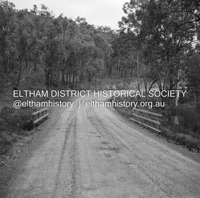
Negative - Photograph, J.A. McDonald, Heidelberg-Kinglake Road, Sep. 1959
Job 56M430 Contractor Hone Deviation opposite looking north from Hurstbridge endRecord of various Shire of Eltham infrastructure works undertaken during the period of 1952-1962 involving bridge and road reconstruction projects, sometimes with Eltham Shire Council Project Reference numbers quoted. It was during this period that a number of significant improvements were made to roads and new bridges constructed within the shire that remain in place as of present day (2022). In many situations, the photos provide a tangible visible record of infrastructure that existed throughout the early days of the Shire. The album was put together by or under the direction of the Shire Engineer, J.A. McDonald.infrastructure, shire of eltham, road construction, 1959-09, heidelberg-kinglake road -
 Eltham District Historical Society Inc
Negative - Photograph, J.A. McDonald, Reconstruction works, Lower Plenty Oval, Jan. 1961
3 February 1961 Looking towards Rattray RoadRecord of various Shire of Eltham infrastructure works undertaken during the period of 1952-1962 involving bridge and road reconstruction projects, sometimes with Eltham Shire Council Project Reference numbers quoted. It was during this period that a number of significant improvements were made to roads and new bridges constructed within the shire that remain in place as of present day (2022). In many situations, the photos provide a tangible visible record of infrastructure that existed throughout the early days of the Shire. The album was put together by or under the direction of the Shire Engineer, J.A. McDonald.1961-01, infrastructure, lower plenty oval, reconstruction works, shire of eltham -
 Eltham District Historical Society Inc
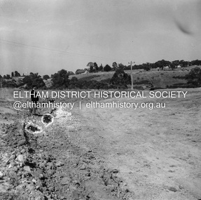
Negative - Photograph, J.A. McDonald, Para Road, Mar. 1961
Wash out 51 Para Road after heavy rain 28 March 1961Record of various Shire of Eltham infrastructure works undertaken during the period of 1952-1962 involving bridge and road reconstruction projects, sometimes with Eltham Shire Council Project Reference numbers quoted. It was during this period that a number of significant improvements were made to roads and new bridges constructed within the shire that remain in place as of present day (2022). In many situations, the photos provide a tangible visible record of infrastructure that existed throughout the early days of the Shire. The album was put together by or under the direction of the Shire Engineer, J.A. McDonald.infrastructure, shire of eltham, 1961-03, flood damage, para road -
 Eltham District Historical Society Inc
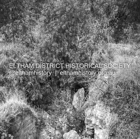
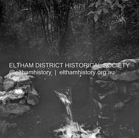
Negative - Photograph, J.A. McDonald, Hurstbridge Water Scheme, 11 May 1961
Downstream view of V notch 11 May 1961 http://wikimapia.org/10473910/Running-Creek-ReservoirRecord of various Shire of Eltham infrastructure works undertaken during the period of 1952-1962 involving bridge and road reconstruction projects, sometimes with Eltham Shire Council Project Reference numbers quoted. It was during this period that a number of significant improvements were made to roads and new bridges constructed within the shire that remain in place as of present day (2022). In many situations, the photos provide a tangible visible record of infrastructure that existed throughout the early days of the Shire. The album was put together by or under the direction of the Shire Engineer, J.A. McDonald.infrastructure, road construction, shire of eltham, 1961-05-11, hurstbridge water scheme -
 Eltham District Historical Society Inc
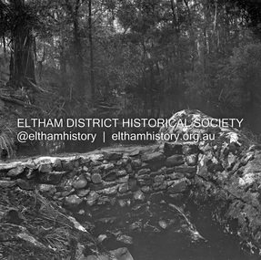
Negative - Photograph, J.A. McDonald, Hurstbridge Water Scheme, 11 May 1961
Downstream view of wall in creek and leak 11 May 1961 http://wikimapia.org/10473910/Running-Creek-ReservoirRecord of various Shire of Eltham infrastructure works undertaken during the period of 1952-1962 involving bridge and road reconstruction projects, sometimes with Eltham Shire Council Project Reference numbers quoted. It was during this period that a number of significant improvements were made to roads and new bridges constructed within the shire that remain in place as of present day (2022). In many situations, the photos provide a tangible visible record of infrastructure that existed throughout the early days of the Shire. The album was put together by or under the direction of the Shire Engineer, J.A. McDonald.infrastructure, road construction, shire of eltham, 1961-05-11, hurstbridge water scheme