Showing 44519 items
matching land-conservation-east-gippsland
-
 Whitehorse Historical Society Inc.
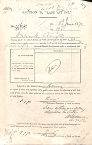
Document - Report, Section 31 Land Act 1869, 01/06/1872
Land application by Frank Ainger, referred to District Surveyor. Report by Mounted Constable Douglas with description of proposed use of land. Map of area. The area is on the corner of Whitehorse Road and Doncaster East Road.ainger, frank, douglas (mounted constable), assistant commissioner of lands and survey, whitehorse road, mitcham, doncaster east road, land settlement -
 Kew Historical Society Inc
Administrative record, East Kew Women's Club, Attendance Register, 1967-1971
The East Kew Women’s Club was formed on 20 July 1945 as an experiment amongst local women, who felt that there was a need for some organised group to give full scope to their various interests and hobbies. In the beginning, they met at the house of their founder, Mrs Eric Thake, 48 Harp Road, East Kew, but the growth and interest was so rapid that it was soon necessary to find a larger meeting place, so the group moved to the Harrier’s Pavilion in Victoria Park, Kew. At the fifth meeting of the group, a committee was formed, and a constitution adopted on 4 December 1945.The Club was aimed to be non-political, non-sectarian and open to women from any locality. The Club’s motto was “To Help others, Improve Ourselves, and Foster the Community Spirit”. The first twenty years of the Club was recorded in a small, nine-page publication “East Kew Women’s Club : Twenty Years 20-7-1945 - 30-7-1965”. Following the closure of the Club in 1973, after twenty-eight years, its records were deposited with the Kew Historical Society and are thus available for research into the history of women’s groups in the post war period in Australia. The Society holds the Club’s Minute Books of Meetings (1953-73), Attendance Registers (1959-73), Visitors Book, and sundry items of print ephemera published by the Club.Register, East Kew Women’s Club, 1967-71east kew women's club, community groups -- kew east (vic.) -
 National Vietnam Veterans Museum (NVVM)
Audio - Audio, CD, Radio interview of Krishna Methven, Jo Parker, Gary Parker & Bill Noble
Interview done by West Gippsland Community Radio, February 2007national vietnam veterans museum -
Lakes Entrance Regional Historical Society (operating as Lakes Entrance History Centre & Museum)
Photograph, 1903 c
Man at fire looks like Nicholas Caire Photographer. Woman Mrs Caire who often travelled with him. Young man possibly H D Bulmer who travelled with Caire and learned photography. Other man helped lug the gearBlack and white photograph showing three men and a woman at a basic campsite of tarpaulin tent washing line and open air cooking in East Gippsland Victoriabusinesses -
Lakes Entrance Regional Historical Society (operating as Lakes Entrance History Centre & Museum)
Postcard, 1/02/2021 12:00:00 AM
First child of John Victor and Myrtle Olive Fish nee GrantSepia toned postcard of Rex Owen Fish aged five months wearing lace trimmed baby frock seated on a chair East Gippsland Victoriaroad construction and maintenance -
 Lakes Entrance Regional Historical Society (operating as Lakes Entrance History Centre & Museum)
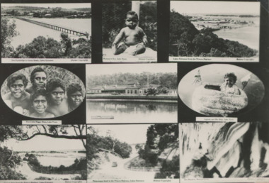
Postcard - Scenes from around Lakes Entrance and Lake Tyers, H D Bulmer, 1930c
Includes Club Hotel, Jemmys Point , Footbridge , Buchan Caves Black and white collage postcard showing views of Lakes Entrance, Buchan and Lake Tyers Station residents to advertise local area East Gippsland Victoriasettlement, buildings, community facilities, aboriginal history -
 Federation University Historical Collection
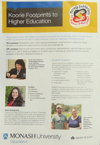
Pamphlet - Brochure, Koorie Footprints to Higher Education, Gippsland, 1913, 2012
On 01 January 2014 Monash University Gippsland became a campus of Federation University Australia.Double side A3 sheet outlining a program for indigenous people to increase their knowledge about the university and to create opportunities to attend Monash University Gippsland. Photographs include Aunty Jenny Solomon, Gina Bundle, Nick Johnson, Vicky Murgha, Pauline Mackinnon, Bronwyn Boyce. Courtney Hales, Pro Vice-Chancellor Helen Bartlett.aunty jenny solomon, gina bundle, nick johnson, vicky murgha, pauline mackinnon, bronwyn boyce, courtney hales, helen bartlett., monash university gippsland, aborigines, aboriginal education centre, printmaking, koorie footprints, gippsland campus collection, nicholas johnson -
Clunes Museum
Document - CONSERVATION STUDY, RICHARD AITKEN, 1986
REPORT FOR THE SHIRE OF TALBOT & CLUNES 'AUSTRALIAN HERITAGE COMMISSION'& MINISTRY FOR PLANNING & ENVIRONMENT, BY RICHARD AITKEN - 10TH APRIL, 1986TALBOT AND CLUNES CONSERVATION STUDY - HISTORY OF SIGNIFICANT BUILDINGS.local history, document, report, hepburn shire -
 Orbost & District Historical Society
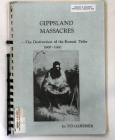
book, Gardner, Peter, Gippsland Massacres, 1983
This is an early European history of the region that saw the population of the Kurnai tribes plummet from 3000 to less than 300 in twenty years. Gardner examines the details of five major massacres of Aboriginals that occurred in Gippsland before 1852, as well as other massacre sites.A spiral bound book titled "Gippsland Massacres" written by Peter Gardner, The Destruction of the Kurnai Tribe 1800-1860. It has a pale blue cover with black text and a photo of a seated Aborigine. it has 113 pp.aboriginal-history-east-gippsland kurnai massacres -
Camberwell Historical Society
Pamphlet (Item) - Flier, Australian Institute of Genealogical Studies Inc, Camberwell Urban Conservation Study now available for purchase
camberwell, urban conversation study -
Lakes Entrance Regional Historical Society (operating as Lakes Entrance History Centre & Museum)
Book, Fletcher Meredith, Squires Debra, Barraclough Linda, Gippsland Heritage Journal Vol 1 No. 1, 1986
Early discovery of Bass Straight and Gippsland coast and social history of Gippsland Victoriaexplorers, township, bibliography -
 Orbost & District Historical Society
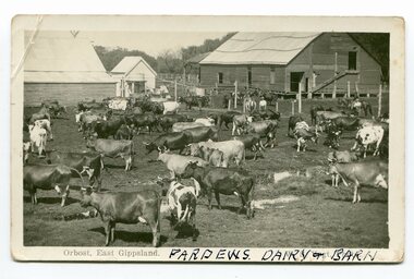
black and white photograph/ poscards, Vogt. W.S, C1890 - 1920
Edward James Pardew died in 26/9/1927 aged 92. He came to Orbost from New Zealand in 1886 and selected 720 acres of hill land in the Brodribb area. He was a member of the first Orbost Shire Council. His daughter had a fruit & meat shop in McLeod Street. He was an inaugural vestryman of St James Church of England. One of the most prominent farmers on the Snowy was John Gilbert, a large landowner. His breeding establishment was at Tullagoota, about two and a half kilometres down the river from Orbost.Dairying in the Orbost district was once a mainstay of the farming community. Today the properties are fewer and smaller.Two black / white photographs of dairy herds. 3188.1 - on front - printed -"ORBOST EAST GIPPSLAND"; hand-written - :PARDEWS DAIRY & BARN" 3188.2 - on front - printed - " W. S. VOGT"; hand-written - "DAIRY HERD TALLAGOOTA< ORBOST"dairying-orbost agriculture-orbost pardew-dairy tallagoota-dairy -
 Ringwood and District Historical Society
Photographs, East Ringwood Shops in Railway Avenue circa 1980s (6 photos), 1997
Colour photos of the Ringwood East shopping centre. Query drainage works and autumn trees.East Ringwood shops - hardware shop at roundabout (3274_001); East Ringwood shops - post office (3274_002); East Ringwood shops - Paul's supermarket (3274_003); East Ringwood shops - unknown street (3274_004); East Ringwood shops - Lawrence Grove corner (3274_005); East Ringwood shops - Wright Bros (3274_006) -
Marysville & District Historical Society
Map (item), Taungurung Land and Waters Council Aboriginal Corporation, Unknown
A map of the area in Victoria which is the land of the Taungurung Clan.A map of the area in Victoria which is the land of the Taungurung Clan. Taungurung Land and Waters Council (TLaWC) was registered 16 July 2009 as the Registered Aboriginal Party that represents the interests of the Taungurung people. TLaWC is the corporate representative and ‘face’ of the Taungurung people and serves to uphold their interests with respect to culture and country. The Taungurung people occupy much of central Victoria. Their country encompasses the area between the upper reaches of the Goulburn River and its tributaries north of the Dividing Range. From the Campaspe River to Kilmore in the West, eastwards to Mount Beauty, from Benalla in the north down to the top of the Great Dividing Range, their boundaries with other Aboriginal tribes are respected in accordance with traditional laws.taungurung clan, taungurung land and waters council aboriginal corporation, victoria -
 Melbourne Tram Museum
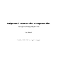
Document - Report, Yan Gaoulil, Conservation Management Plan for The Tramway Signal Cabin, Apr. 2017
Report - 28 A4 pages, double sided stapled in the top left hand corner titled "Conservation Management Plan for The Tramway Signal Cabin, Waiting Shelter and Conveniences at Swanston Street and Victoria Street Melbourne". Prepared by Yan Gaoulil as part of an assignment when undertaking Conservation Management Plan studies. Provides a introduction to the study, history, description, significance, Key Issues, Policy, implementation for the conservation of the building. Includes a Bibliography and Appendices. A second set of documents, five pages stapled in top left hand comer, lists correspondence between the Author and the Museum commencing Dec. 2016.trams, tramways, waiting shelters, franklin st, conservation planning, signal box, swanston st -
Lakes Entrance Regional Historical Society (operating as Lakes Entrance History Centre & Museum)
Financial record - Ledger, Country Roads Board Wages Ledger, 1953
A Ledger of Wages paid to Country Roads Board employees of East Gippsland VictoriaA Ledger of Wages paid to Country Roads Board employees of East Gippsland Victoriaaccounts book -
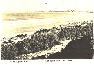 Port Fairy Historical Society Museum and Archives
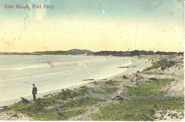
Postcard, The Rose Series / The Rose Stereographs, East Beach, Port Fairy Victoria
Black and white Photograph of East beach looking East South East with dunes in the foreground and the bay and Griffith Island in the background taken for use as a postcardThe Rose Series P.1144. Copyright East Beach Port Fairy Victoriaeast beach, dunes, sea, ocean, griffith island -
 B-24 Liberator Memorial Restoration Australia Inc
Map - Silk Escape Map, NO. C45 EAST BORNEO
These maps were used by Air crew in case of air craft crashing.Fabric map of East Borneo.AAF CLOTH CHART NO. C-45 EAST BORNEO (Other side Chart No. C-46) No.C-45 EAST BORNEO S120-E11340/540Nx520 -
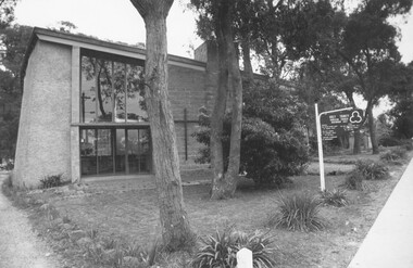 Ringwood and District Historical Society
Photograph, Holy Trinity Anglican Church Ringwood East 1973
Holy Trinity Anglican Church Ringwood EastWritten on backing sheet, "Rwd. East. 30.9.73" -
 Eltham District Historical Society Inc
Book, Conservation Management Plan - Eltham Justice Precinct (January 2006) prepared for Nillumbik Shire
Guidance on the heritage issues in the management of the court house and former police buildings of the early justice precinct at Eltham.68 p, 30 cm. Also draft copy - Conservation Management Plan (draft) for Justice Precinct Eltham (July 2005) prepared for Nillumbik Shire 2006 This copy is the property of the Eltham District Historical Society Inc.eltham justice precinct, justice precinct eltham -
Lakes Entrance Regional Historical Society (operating as Lakes Entrance History Centre & Museum)
Photograph, 1935-36
Relief gang burning charcoal for gas producers written on back of photograph but may be unemployed on Sustenance clearing roads and tracks. Tools shown axes, picks, fern hooks, slashers, sledghammersBlack and white photograph of fourteen men with two dogs and one cat at the single mens camp at The 4 Mile Old Buchan Road East Gippsland Victoriasports, celebrations -
Lakes Entrance Regional Historical Society (operating as Lakes Entrance History Centre & Museum)
Photograph, 1935-36
Black and white photograph of eight bush workers Charles Pettman with a dog posed in a bush setting at the Four Mile Old Buchan Road East Gippsland Victoriasports -
Lakes Entrance Regional Historical Society (operating as Lakes Entrance History Centre & Museum)
Photograph, 2001 c
Jack and James Sotirakis born 13 June 1994, Reece Deppler born 20 February 1993Colour photograph of three young boys Reece Deppler with Jack and James Sotirakis taken at a local celebration, shrubs in background decorated with streamers East Gippsland Victoriahouses -
Lakes Entrance Regional Historical Society (operating as Lakes Entrance History Centre & Museum)
Photograph, 1910 c
The people in the photograph are dressed up as if a special occasionBlack and white photograph of a group of hop pickers and families, hop poles on ground in front of people, others at back not picked, two bicycles, East Gippsland, Victoriacelebrations -
Lakes Entrance Regional Historical Society (operating as Lakes Entrance History Centre & Museum)
Album - Photograph, LERHS members, 2002 c
Small album of photographs taken during LERHS visit to Mallacoota plus those during Mallacoota Historical Society visit to Lakes Entrance Victoria East Gippslandvolunteering, community facilities -
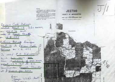 Federation University Historical Collection
Map - Documents, Documents relating to Land - Selection of Maps of subdivisions; Titles; Cemetery sections
Maps indicate the land owned in various areas of Victoria - Mornington Peninsula, Ascot / Creswick areaLand maps showing block divisions and owners. Edward Carter Holmes J.P. selected land and called it Launchley - later called Wambalano.jeetho, county of mornington, edward carter holmes, joseph clarke, catherine holmes, talbot, william coghill, pre-emptive right, tourello pre-emptive right, glendonald pre-emptive right, clunes, smeaton, ascot, counties of ripon and talbot, certificate of title, ballaarat general cemetery, new cemetery, poowong, helen coghill -
 Melbourne Tram Museum
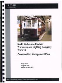
Document - Report, Gary Vines, Biosis Research, "North Melbourne Electric Tramways and Lighting Company Tram 13 Conservation Management Plan", Aug. 2007
Report or plan - 91 A4 pages, clear plastic cover, black card back cover, bound with a black comb binder, titled "North Melbourne Electric Tramways and Lighting Company Tram 13 Conservation Management Plan", providing a detail Conservation Plan for the tramcar. Includes project background, documentary evidence, details of the NMETL, tramcars, similar trams, its history, physical evidence, statement of significance, Conservation policy and implementation, and conclusions. Includes appendices, references and a glossary. Prepared by Gary Vines, Biosis Research, August 2007 for VicTrack. Includes a loose single sheet giving details of the colour scheme.trams, tramways, victrack, conservation planning, nmetl, colour schemes, tram 13 -
 Port Fairy Historical Society Museum and Archives
Photograph - Postcard, East Beach Port Fairy
Shows old pier and remnants of wharf railEvidence of former pier and wharf railB&W PhotographEast beach Port Fairybeach, seascape, pier -
 Orbost & District Historical Society
black and white photographs, 1890s
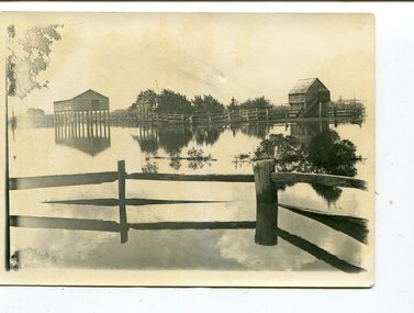
Peter Cameron, came to Orbost in 1885, at the age of 69, having sold his farm at Geelong. Peter bought the property ―Glen Avon from a Mr Street. The home was situated at the bottom of the paddock, near the corner of Morley and Livingstone streets. The farm stretched from Tennyson Street to the end of Snaggers Lane and along the river frontage to “Carinya” Cameron Home. In the Gippsland Times on Wednesday. 2 Jul 1890 on Page 3 is an article titled "THE SNOWY RIVER CALAMITY" which describes an ".unexpectedly sudden rush of water down the flats..... the terrified people commenced to remove their stock from the land and the work of saving property was continued all day ............ many head of cattle were washed away.......The river road, for its entire length, is obliterated, and the approaches to the bridge at Watt's Gulch are gone, with the enormous volume of flood water," These photographs are pictorial records of a significant event in the history of Orbost. There are few personal records of the very early floods.Three black / white photographs of wooden buildings with flood water in foreground. There are post and rail fences. 3193.2 has been taken from a distance.on back -" "Glenavon east of Lagoon 1897 Feb"floods-orbost-1890s glenavon-orbost -
Federation University Historical Collection
Report, Ballarat Conservation Study Part 2, 1980, 1980
Commissioned by the City of Ballaaratm the Historical Buildings Preservation Council and the Australian Heritage Commisssion.The final report of the Ballarat Conservation Study, including introduction and objectives, study area, summary of recommendations, significant streetscapes, aeras and works recommended for lisitng on the National Estate.wendy jacobs, miles lewis, gary vines, ballarat heritage study, ballarat, heritage, architecture, national estate, streetscapes