Showing 5025 items matching "library of victoria"
-
 Warrnambool and District Historical Society Inc.
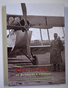
Book - Biography of Charles Pratt, Kevin O'Reilly, Charles Pratt of Belmont Common, 2016
... collection of photographs now in the State Library of Victoria. ... of photographs now in the State Library of Victoria. This book is of some ...Biographical material of Charles Pratt and diary extractsThis is a book of 280 pages with a blue and brown hard cover with sepia -coloured photographs on the front and back covers and multi-coloured print on the cover and spine. The dust cover has the same content as the hard cover. The pages contain printed text, black and white photographs, charts and sketches. non-fictionBiographical material of Charles Pratt and diary extracts charles pratt, 1920s aerial photographs, warrnambool history -
 Vision Australia
Photograph - Image, Foto Group, 2008 John Cain visit to Kooyong, 13/6/2008
... On June 13, 2008 former Premier of Victoria John Cain... as fellow members from the PLVN (Public Libraries of Victoria ...On June 13, 2008 former Premier of Victoria John Cain and his wife Nancye visited the Kooyong office of Vision Australia. After viewing demonstrations of a magnifier, screen reader and Daisy book, Mr Cain spoke to a group of VA staff and clients as well as fellow members from the PLVN (Public Libraries of Victoria Network). He later recorded an interview for VA Radio.40 digital images of John and Nancye Cain's visit to Kooyongvision australia, john cain, nancye cain, julie rae, tim evans, tony iezzi, debra rosenfeldt, jim pipczak, kevin murfitt, david blyth, stephen belbin, anne-marie schwirtlich, lorraine seeger, claude ullin, carolyn macvean, maryanne diamond -
 Port Melbourne Historical & Preservation Society
Postcard - Town Pier, Port Melbourne, 01: A H Harvey, .02: A C Green, 1890 - 1945
... by A C Green and part of the State Library Victoria Collection... photographs taken by A C Green and part of the State Library Victoria ...Purchased on E Bay March 2016Two photographic postcards purchased on Ebay. .01 Town Pier from the Eastern Beach c1890-1900 .02 Wanganella Hospital Ship at Station Pier 31.12.1945 Both photographs taken by A C Green and part of the State Library Victoria Collectionpiers and wharves - town pier, piers and wharves - station pier, war - world war ii, wanganella, a c green, j h harvey -
 Kew Historical Society Inc
Photograph - Opening of the Dorothy Rogers Reserve, 1976
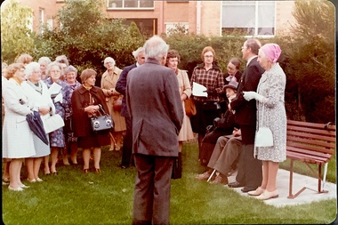
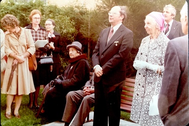
... are held in the collections of the State Library of Victoria... in the collections of the State Library of Victoria and Kew Historical ...Dorothy Rogers wrote two major books on Kew's history: Lovely Old Homes of Kew (1961) and A History of Kew (1973). In addition to her published works, she was a regular contributor on issues of local history to suburban newspapers. Her archives are held in the collections of the State Library of Victoria and Kew Historical Society. Three years after her death in 1973, the Reserve was opened in her honour.Faded colour positive photograph of the opening of the Dorothy Rogers Reserve in 1976. The naming of the reserve honoured the contribution of the historian Dorothy Rogers, foundation member of the Society. The reserve is located on the north side of Studley Park Road just west of Kew Junction. Inscribed verso: "Members and relatives of the late Dorothy Rogers. Memorial reserve named and unveiled in her honour by (Cr Whiting Mayor) and City Manager Mr Fell 1978. In respect for her great research and service to the history of early Kew, and other places."dorothy rogers reserve, public parks -- kew (vic.) -
 Kew Historical Society Inc
Photograph - Opening of the Dorothy Rogers Reserve, 1976
... are held in the collections of the State Library of Victoria... in the collections of the State Library of Victoria and Kew Historical ...Dorothy Rogers wrote two major books on Kew's history: Lovely Old Homes of Kew (1961) and A History of Kew (1973). In addition to her published works, she was a regular contributor on issues of local history to suburban newspapers. Her archives are held in the collections of the State Library of Victoria and Kew Historical Society. Three years after her death in 1973, the Reserve was opened in her honour.Faded colour positive photograph of the opening of the Dorothy Rogers Reserve in 1976. The naming of the reserve honoured the contribution of the historian Dorothy Rogers, foundation member of the Society. The reserve is located on the north side of Studley Park Road just west of Kew Junction. Inscribed verso: "Left to right: Mrs Rogers Jnr, Joy Stewart, Miss Jenkins sitting / Mrs Richardson and Mr Richardson, Brother of D. Rogers), Mayor Cr Whiting, City Manager Mr Fell, Background / KHS President Miss Hall, Mr B O'Neill KHS member, / taken during the memorial unveiling of the Dorothy Rogers Reserve"dorothy rogers reserve, public parks -- kew (vic.) -
Surrey Hills Historical Society Collection
Book, Professional and Business People in Box Hill to 1925, 1993
... Library of Victoria researching and copying information... at the State Library of Victoria researching and copying information ...This book gives information about professional and business people that is taken from the Sands and McDougall Directories. In 1887, the first year Box Hill appeared, addresses were not given but thereafter they are. It must be pointed out that directories are not always up to date or one hundred percent accurate. Mrs Perrin and Mrs Joyce Ivory spent many hours at the State Library of Victoria researching and copying information for this book.This book gives information about professional and business people that is taken from the Sands and McDougall Directories. In 1887, the first year Box Hill appeared, addresses were not given but thereafter they are. It must be pointed out that directories are not always up to date or one hundred percent accurate.pioneers - victoria - box hill, businessmen - victoria - box hill, box hill, women in business, (mrs) edna perrin -
 Flagstaff Hill Maritime Museum and Village
Photograph - Historical, maritime, 1878
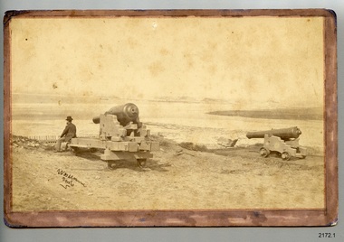
... in the State Library of Victoria (SLV). The photograph in the State... in the State Library of Victoria (SLV). The photograph in the State ...The location of this photograph is disputed by historians, but the consensus is that is shows the early use of Flagstaff Hill by the Warrnambool Garrison. This photograph is very similar to one on file in the State Library of Victoria (SLV). The photograph in the State Library's collection is clearer, and is in black and white. It also has an inscription below it "Lady Bay, Warrnambool, 1878'. The inscription on the lower left of the SLV's photograph looks to be the same as on Flagstaff Hill's copy. The photographer is unidentified. The photograph is significant to Warrnambool's local history. It is connected to the 1870's defence of the Port of Warrnambool, and to southwest Victoria's coast. The photograph can be used as a comparative tool for measuring the changes in the landscape and the harbour.Photograph, sepia, on card. Unknown photographer. View towards Lady Bay, Warrnambool. A gentleman is seated on one of two cannon carriages with cannon, on a hill above a picket fence. A moored sailing ship is in the bay. Hills are in the background and la building is on land to the right. The photograph is mounted on card with a brown, hand coloured border on the front. The corners on the card are rounded. the reverse has round marks in the corners indicating that the photograph has been previously mounted, perhaps in an album. There is a purple stamp and some pencil inscriptions. A handwritten pen inscription is on the lower left corner of the front. [(1b) This black and white photograph is a copy of the original and has been printed on larger paper.]Front: "[undecipherable] / photo" Reverse in pencil: " REG. NO. 2172.1 / ORIGINAL" Reverse, stamped: "Flagstaff Hill Maritime Village"flagstaff hill, warrnambool, shipwrecked-coast, flagstaff-hill, flagstaff-hill-maritime-museum, maritime-museum, shipwreck-coast, flagstaff-hill-maritime-village, photograph, warrnambool, lady bay, lake pertobe, cannon hill, middle island, steam ship, breakwater, cannon, victoria, man seated on cannon, 1878, militia fort, port of warrnambool, militia, garrison, warrnambool garrison -
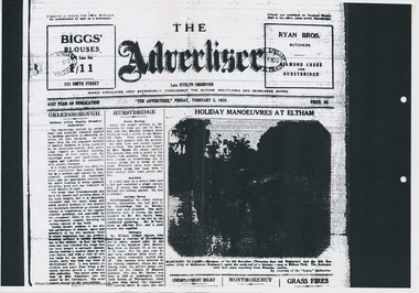 Eltham District Historical Society Inc
Folder, Military camps in the Eltham area, 2008
... book, printout of photo from State Library Victoria and various... book, printout of photo from State Library Victoria and various ...Folder of information including a list of Military Camps in the Eltham area 1930-1940. Including photocopy of pages from unknown book, printout of photo from State Library Victoria and various copies of historial newspaper articles researched by Jim Allen in 2008HG Booklet 4harry gilham collection, military camps, eltham -
 Mission to Seafarers Victoria
Photograph - Digital photograph, colour
... recorded in newspaper articles and sourced from the State Library...Mission to Seafarers Victoria 717 Flinders Street Docklands ...As we celebrate #InternationalWomensDay, did you know that to reflect its role as an international organistaion caring for all seafarers regardless of gender, our name was changed from the Mission to Seamen in 2000? Pictured here is Cadet Hamer with one of Catherine Bell’s mugs from The Sea-fairer Sex (2017) - an installation that explores the global history of women in seafaring recorded in newspaper articles and sourced from the State Library of Victoria. #IWD2018women, cadet hamer, seafaring, 2018 -
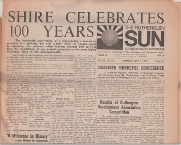 Rutherglen Historical Society
Newspaper, Rutherglen Sun and Chiltern Valley Advertiser. Vol. 88. No. 26. Thursday, July 1, 1971, 1/07/1971
... copies of the Rutherglen Sun held by the State Library... copies of the Rutherglen Sun held by the State Library ...Special issue of the Rutherglen Sun to celebrate the 100th anniversary of Rutherglen Shire. This issue may be one of the few available, as it does not appear to have been included in the bound copies of the Rutherglen Sun held by the State Library of Victoria, from which microfilm copies of these papers were produced. The Rutherglen Historical Society has scanned this issue so that the digital copy may be used for reference, and the paper copy carefully preserved.Single issue of newspaper, The Rutherglen Sun and Chiltern Valley Advertiser, celebrating the 100th anniversary of the Rutherglen Shire. The main section of the paper consists of 8 pages covering the shire council and Rutherglen itself at the time of publication. There is an 8 page insert on slightly smaller paper covering the founding of the shire, and the early history of the region.rutherglen shire, centenary -
 Halls Gap & Grampians Historical Society
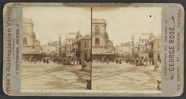
Photograph - B/W, C 1880
... State Library Victoria, Rose's Australasian Views Victorian... Library Victoria, Rose's Australasian Views Victorian Series ...1880-1902 Land owned by Robert and Sarah Graham who owned a large portion of land best described as Upper Fyans Valley. At some time after 1880, they sold a parcel of the land under Sundial Peak to David Austin who built a slab hut. C1896, The land was sold to James and Amy Balmain which they named 'Bellfield' Amy was a daughter of John D/Alton who built the Stawell Water Supply System. Balmain purchased the vacant school cottage at Burnt Bridge and moved it to 'Bellfield' Over the next six years the house was enlarged to accommodate their growing family but sold in 1902 following the death of Amy Balmain.House with addition People leaving house by horse and carriage, people standing in groundsState Library Victoria, Rose's Australasian Views Victorian Series photographed and published by George Rose 123 Chapel St., Windsor, Victoriabuildings, houses, bellfield -
 Greensborough Historical Society
Book - Collection of articles, Parliamentary Library, John Cain, 2020
... of articles was produced by the Parliamentary Library, Victoria.... Premier of Victoria 1982-1990, Member for Bundoora 1976-1992 ...John Cain, 1931-2019 was the 41st Premier of Victoria 1982-1990, Member for Bundoora 1976-1992.This collection of articles was produced by the Parliamentary Library, Victoria.Compilation of articles and tributes relating to John Cain 1931-2019. Bound with plastic cover.john cain, victoria politics, politicians -
 Ballarat Tramway Museum
Photograph - Digital image, Rose Stereograph Co, c1895?
... Digital image from the State Library of Victoria website... Photograph tram 5 of 6? Digital image from the State Library ...Yields information about the appearance of the intersection of Grenville and Bridge St following the introduction of the horse trams and the terminal arrangements.Digital image from the State Library of Victoria website image No. H92.291/24, a Rose series stereo photograph showing a horse tram just after off loading at the Grenville St terminus. Shows the view along Bridge St with the Nicholl and Allan store, Bucks Head hotel, Reed Chemist and C. Morris Hatter sign. C1895? Has a number of people in the view. The horses are being "run around the tram". Tram has the destination of "Convent", could be No. 6 or 5. See image btm7019i2.pdf for the SLV link - correct as of 31-12-17. See image i3 for a more detailed photograph.trams, tramways, bridge st, grenville st, sturt st, horse trams, stereo photograph, tram 5 of 6? -
 Ballarat Tramway Museum
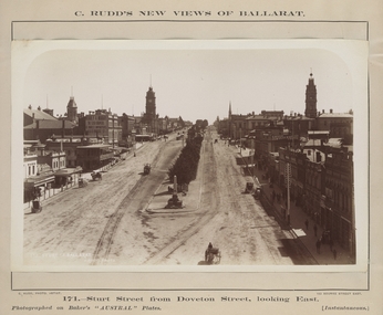
Photograph - Digital image, Charles Rudd, c1890?
... Digital image from the State Library of Victoria website... from the State Library of Victoria website image No. H39558/12 ...Yields information about the appearance of Sturt St following the introduction of the horse trams.Digital image from the State Library of Victoria website image No. H39558/12, a Charles Rudd photograph showing a view from the Nicholl and Alan building looking west along Sturt St. Shows the buildings along either side of Sturt St and a horse tram descending the hill. Very little other traffic in the photograph. Has signs for "C. Huck - The Queen's studio photo" and "Morrey and Murray", the Cash Drapers on the Ballarat Mechanics Institute building. Note the caption of the photograph is incorrect. See image btm7019i2.pdf for the SLV link - correct as of 31-12-17. See image i2 for a more detailed photograph.trams, tramways, grenville st, sturt st, horse trams -
 Bendigo TAFE
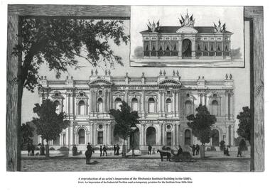
Print, A reproduction of an artist's impression of the Mechanics Institute Building in the 1880's, 20th Century
... and free library: the new and old." [Go to the State Library...Bendigo TAFE Bendigo TAFE Library 136 McCrae St Bendigo ...This is an artist's impression in reproduction of the Mechanics Institute building as it was in the 1880's. It has since changed quite significantly, especially what can be seen of the surrounds. The insert picture is an impression of the Industrial Pavilion which, as is stated, was used between 1856-1864 as temporary premises for the Institute. The print was first published in 'The Australian Sketcher' under the title "Sandhurst Mechanics Institute and free library: the new and old." [Go to the State Library of Victoria and the following link for more details.] http://www.slv.vic.gov.au/miscpics/gid/slv-pic-aab22020This is a significant print in an historical context, portraying the Bendigo School of Mines and Industries as it was in the 1880's, as well as the Industrial Pavilion. It indicates the significance of it to the community that an artist's impression was sought. Significance assessed in-house.A3 print on heavy paper. A reproduction of an artist's impression of the Mechanics Institute Building in the 1880's. The picture is of the building with an insert impression of the Industrial Pavilion used as temporary premises for the Institute from 1856-1864. It is a black and white print of the front of the building with rough depictions of people, horses, a carriage and trees in front of it."A reproduction of an artist's impression of the Mechanics Institute Building in the 1880's. / Insert. An impression of the Industrial Pavilion used as temporary premises for the Institute from 1856-1864"bendigo school of mines and industries, industrial pavilion, mechanics institute, bendigo, 1880, 1856-1864 -
 Bacchus Marsh & District Historical Society
Map, Village allotments, Parish of Myrniong, County of Bourke
... held at the State Library of Victoria was based on an earlier... held at the State Library of Victoria was based on an earlier ...Myrniong is a village 9 kilometers west of Bacchus Marsh. Prior to 1863 the area was known as Blow's Flat. This map which was produced in 1903 and according to the catalogue record of this map held at the State Library of Victoria was based on an earlier map created in 1861. The early layout of streets for the village of Myrniong can be seen on this map. The streets shown are, Main Street, Hardy Street, Blow Street, Myrniong Street, Shuter Street, and Blackwood Street. An area marked as a reserve for a school can be seen between Hardy Street and Main Street.A single page paper map. A cadastral parish map of Myrniong in Victoria, showing numbered land allotments. Photo-lithographed at the Department of Lands & Survey, Melbourne, in 1903. Based on an original map created in 1861. The map is pasted into a bound volume containing 76 maps or plans in total. High resolution digital image stored on BMDHS computer network. Surveyed by John Hardy, Surveyor ; photo-lithographed at the Department of Lands & Survey, Melbourne by T.F. McGauran, 24.12.03myrniong parish plan, myrniong parish maps -
 Bacchus Marsh & District Historical Society
Map, Allotments in the Village of Rowsley, Parish of Gorrocburkghap, County of Grant c.1856
... held by the State Library of Victoria (SLV) contains slightly... held by the State Library of Victoria (SLV) contains slightly ...Rowsley is a locality 11 kilometers south-west of Bacchus Marsh. The date of this map is uncertain. A very similar map held by the State Library of Victoria (SLV) contains slightly more information than this copy and is dated as an 1856 map. SLV reference: 'Allotments in the Village of Rowsley, Parish of Gorrocburkghap, County of Grant', by T. Nixon, Assistant Surveyor, May 1856 ; Surveyor General’s Office, July 18 1856 (lithographed by R. Meikle). (1856). Melbourne: Surveyor General’s Office. MAPS 820 BJE 1837- ROWSLEY 1856. A single page paper map. A cadastral map of the Village of Rowsley in Victoria, showing numbered land allotments. 57 allotments are shown on the map and some areas set aside as reserves. Allotments 8, and 10-16 are outlined in red ink and allotment 9 has a cross in red ink on it. The map is pasted into a bound volume containing 76 maps or plans in total. High resolution digital image stored on BMDHS computer network. rowsley victoria history, rowsley victoria maps -
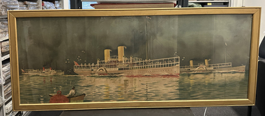 Port Melbourne Historical & Preservation Society
Poster - PS Weeroona, PS Hygeia and PS Ozone, Deane Taylor, c 1912
... for a postcard by B R Gowan & Co held by the State Library of Victoria.... for a postcard by B R Gowan & Co held by the State Library of Victoria ...Appears to be a trimmed version of an advertising poster for the bay steamers, Weeroona, Hygeia and Ozone. The original poster has a brown border with 'Health and Pleasure Trips on Port Phillip Bay' above the picture and 'by the "Weeroona" "Hygeia" and "Ozone"' below the picture. The border and some of the picture, including the artist's signature, have been removed to create this item. The Nepean Historical Society Inc. hold an intact version of the advertising poster. The full version of the image was also used for a postcard by B R Gowan & Co held by the State Library of Victoria.Large unsigned, framed poster of PS Weeroona, PS Hygeia and PS Ozone formerly owned by Captain Harry GRAY. Glass fronted.piers and wharves - station pier, transport - shipping, arts and entertainment - visual arts, captain george henry (harry) gray, ps weeroona, ps hygeia, ps ozone, bay cruisers -
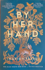 Hymettus Cottage & Garden Ballarat
Work on paper - Book, By Her Hand
... Library Victoria on 12th March 2025. Hymettus Cottage was home... Library Victoria on 12th March 2025. Hymettus Cottage was home ...Set in tenth century England in the time of Aethelflaed of Mercia and the consolidation of Mercia, Wessex and other regions prior to the rise of Edward 1st. The work relates the story of a girl who is subjected to a hard father and suffers from the devastation of Viking raids before advancing through her maturity and independence from male domination.See image.fictionSet in tenth century England in the time of Aethelflaed of Mercia and the consolidation of Mercia, Wessex and other regions prior to the rise of Edward 1st. The work relates the story of a girl who is subjected to a hard father and suffers from the devastation of Viking raids before advancing through her maturity and independence from male domination. mercia, wessex, england, aethelflaed, the peak district -
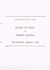 Bendigo Historical Society Inc.
Book - LA TROBE UNIVERSITY BENDIGO COLLECTION: THE SCHOOL LIBRARY COURSE OF STUDY
... Schools.' The School Library, 1956.' Education department....' The School Library, 1956.' Education department, Victoria. A.C ...A soft covered booklet titled 'Course of Study for Primary Schools.' The School Library, 1956.' Education department, Victoria. A.C. Brooks, Government Printer, Melbourne. 32 p. ill.education, primary, school library, la trobe university bendigo collection, bendigo, education, education department victoria, course of study, primary schools, school library, schools, library, teacher training, tertiary education, bendigo teachers' college -
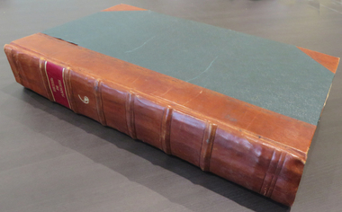 Federation University Historical Collection
Book, Denis Diderot et al, Recueil de planches sur les sciences, les arts libereaux, et les arts mechaniques avec leur explication, 1868, 1768
... for decades. Both State Library of Victoria and Monash University... for decades. Both State Library of Victoria and Monash University ...This book was discovered beneath the floor of a former Ballarat School of Mines office during renovations in 1970. It appears to have been placed there in safe storage, then forgotten for decades. Both State Library of Victoria and Monash University have a full run of all 10 volumes of Recueil de planches sur les sciences, les arts libereaux, et les arts mechaniques avec leur explication. This copy is the sixth volume, and contains 294 pages. School of Mines stamps are dated 1870. Etchings by Benard Fecit and Louis-Jacques Goussier (1722-99). Goussier was a French illustrator and encyclopedist.Large hard covered book of 294 beautifully printed plates on handmade paper. Each plate has descriptions written in French. Along with animals and natural history the images also include mining, metallurgy and mineralogy. Rebound in 1987 with green cloth and leather spine and corners. Gold lettering on the spine. Ballarat School of Mines stamp on the back of each image, dated 1870.printed plates, animals, natural history, metallurgy, mineralogy, mining, minerology, etching, 1768, french, science, briasson, david, le breton, sixth volume -
 Ballarat Tramway Museum
Photograph - Geelong tram No. 2 at T&G Corner Geelong, c1938
... Library of Victoria. See item 8360 for a digital copy of the SLV... negative held at the State Library of Victoria. See item 8360 ...The photo shows Geelong No. 2 in Moorabool St at the intersection with Ryrie St. The tram has the destination of North. The tram is in its modified form that provides for one-man operation. In the photo are Edments, Savoia Cafe, Commercial Bank of Australia, and the T&G building. The photo has been dated between 1935 when the tram was converted and 1939 when the bar neon traffic lights were installed at the intersection. The photograph was taken from a Victorian Railways glass negative held at the State Library of Victoria. See item 8360 for a digital copy of the SLV scan - http://handle.slv.vic.gov.au/10381/97173Yields information about Geelong No.2 and the intersection of Ryrie and Moorabool Streets Geelong.Black and white photograph with a number of rear.In pencil "2171" on rear.tramways, trams, geelong, ryrie st, moorabool st, temperance & general, tram 2 -
 Kew Historical Society Inc
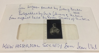
Negative, Ludwig Becker, John Hodgson, 1983
... . Photographed by State Library of Victoria from original held by Royal... Library of Victoria from original held by Royal Historical Society ...Donation includes a letter, dated 12 June 1983 from June Uhl to Mrs [Thea] Sartori referring to research about John Hodgson and the naming of Studley Park.Photographic negative of a lithograph of the Melbourne and Studley Park pioneer John Hodgson, accompanied by a letter from the donor, Jean Uhl.Envelope: "John Hodgson painted* by Ludwig Becker 1855. Photographed by State Library of Victoria from original held by Royal Historical Society of Victoria. Kew Historical Society from Jean Uhl." Editor note: Incorrect attribution. The Becker oil painting is held in the City Collection, City of Melbourne. This negative is of a lithograph based on a drawing of Hodgson, made by L. Becker circa 1855.john hodgson, studley park, stoodley pike - scotland, rev alex davies, jean uhl, ludwig becker -
Glen Eira Historical Society
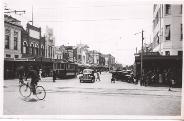
Photograph - TRAMWAYS IN GLEN EIRA
... Library of Victoria (dated 13/01/2012).... Library of Victoria (dated 13/01/2012). Trams Elsternwick Glen ...Three downloaded photographs of trams in Glen Eira: 1/Photocopy of photograph of ‘New Electric Cars (ie trams), Elsternwick Victoria 1913’, reproduced from Howard Bruce, Romance of Australia Trams Photograph Collection c.1870-1976. 2/Untitle photocopy of photograph of trams and crowd, taken on 13/11/1913 (handwritten date) – presumedly of the new electric trams in No.3, above. No specific source mentioned. (National Library of Australia? (dated 27/11/2011) 3/Photocopy of postcard of ‘Glen Huntly Road, Elsternwick’ handwritten ‘c.1913’, from State Library of Victoria (dated 13/01/2012).trams, elsternwick, glen huntly road -
 Stawell Historical Society Inc
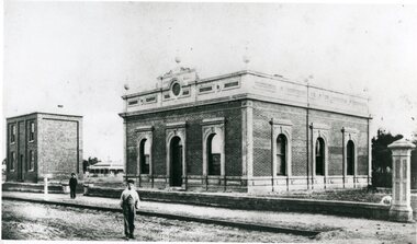
Photograph, Stawell Shire Hall 1866
... This photograph is a copy obtained from State Library... grampians This photograph is a copy obtained from State Library ...This photograph is a copy obtained from State Library of Victoria. The photograph is of Stawell Shire Hall. Two persons can be seen in the foreground. The two story brick building beside the Stawell Shire Hall was once the Literary Institute. The Stawell Shire Hall building has been added to over the years. Ronald Campbell, the Shires second president laid the foundation stone on 28th April. 1866. The contractors were Hutchings and Delbridge. The photograph shows the first hall and office. The building contained simple 18 feet square rooms, with an entrance hall separating them, the facade was almost as it is now. The initial cost of the Shire Hall was $502.Black and white photograph of Stawell Shire Hall as one single storey brick building with parapet on top. Beside the Shire Hall is a two storey brick building. Also, a dwelling between the two building in the background in Cooper St. Two persons in the foreground, one on the road the other on the pathway. stawell -
 Kew Historical Society Inc
Plan, Melbourne & Metropolitan Board of Works : Borough of Kew : Detail Plan No.1576, 1904
... was produced. (Source: State Library of Victoria)... and the State Library of Victoria are monochrome versions which do ...The Melbourne and Metropolitan Board of Works (MMBW) plans were produced from the 1890s to the 1950s. They were crucial to the design and development of Melbourne's sewerage and drainage system. The plans, at a scale of 40 feet to 1 inch (1:480), provide a detailed historical record of Melbourne streetscapes and environmental features. Each plan covers one or two street blocks (roughly six streets), showing details of buildings, including garden layouts and ownership boundaries, and features such as laneways, drains, bridges, parks, municipal boundaries and other prominent landmarks as they existed at the time each plan was produced. (Source: State Library of Victoria)This plan forms part of a large group of MMBW plans and maps that was donated to the Society by the Mr Poulter, City Engineer of the City of Kew in 1989. Within this collection, thirty-five hand-coloured plans, backed with linen, are of statewide significance as they include annotations that provide details of construction materials used in buildings in the first decade of the 20th century as well as additional information about land ownership and usage. The copies in the Public Record Office Victoria and the State Library of Victoria are monochrome versions which do not denote building materials so that the maps in this collection are invaluable and unique tools for researchers and heritage consultants. A number of the plans are not held in the collection of the State Library of Victoria so they have the additional attribute of rarity.Original survey plan, issued by the MMBW to a contractor with responsibility for constructing sewers in the area identified on the plan within the Borough of Kew. The plan was at some stage hand-coloured, possibly by the contractor, but more likely by officers working in the Engineering Department of the Borough and later Town, then City of Kew. The hand-coloured sections of buildings on the plan were used to denote masonry or brick constructions (pink), weatherboard constructions (yellow), and public buildings (grey). Development in the 20th century has irreparably altered that part of Kew represented in this plan. In the block bounded by Cotham Road, Charles Street, Wellington Street and Gellibrand; just one house standing in 1903 remains. This block included two of the most historic houses in Kew: ‘Ordsall’ (later ‘Southesk’) and ‘Madford’ (previously ‘Elm Lodge’). Ordsall was the home of the second chairman of Kew, John Halfey. It contained some of the most significant interior murals in Kew, created for Halfey by artists working for Cullen & Co. It was demolished in 1960 to make way for the Kew Civic Centre. Elm Lodge had been built for William Siddeley in ca. 1864. Arthur Septimus King purchased it in 1874. The lower paddocks of Madford were sold in 1905 by his wife to the Borough of Kew and, after landscaping by George and Thomas Pockett, opened as the Alexandra Gardens in 1908. Elm Lodge/Madford was in 1922 to become St. Anthony’s Home for Little Children before its subsequent demolition in the 1980s.melbourne and metropolitan board of works, detail plans, maps - borough of kew, mmbw 1576, cartography -
 Kew Historical Society Inc
Plan, Borough of Kew Detail Plan No.1577, 1904
... was produced. (Source: State Library of Victoria)... and the State Library of Victoria are monochrome versions which do ...The Melbourne and Metropolitan Board of Works (MMBW) plans were produced from the 1890s to the 1950s. They were crucial to the design and development of Melbourne's sewerage and drainage system. The plans, at a scale of 40 feet to 1 inch (1:480), provide a detailed historical record of Melbourne streetscapes and environmental features. Each plan covers one or two street blocks (roughly six streets), showing details of buildings, including garden layouts and ownership boundaries, and features such as laneways, drains, bridges, parks, municipal boundaries and other prominent landmarks as they existed at the time each plan was produced. (Source: State Library of Victoria)This plan forms part of a large group of MMBW plans and maps that was donated to the Society by the Mr Poulter, City Engineer of the City of Kew in 1989. Within this collection, thirty-five hand-coloured plans, backed with linen, are of statewide significance as they include annotations that provide details of construction materials used in buildings in the first decade of the 20th century as well as additional information about land ownership and usage. The copies in the Public Record Office Victoria and the State Library of Victoria are monochrome versions which do not denote building materials so that the maps in this collection are invaluable and unique tools for researchers and heritage consultants. A number of the plans are not held in the collection of the State Library of Victoria so they have the additional attribute of rarity.Original survey plan, issued by the MMBW to a contractor with responsibility for constructing sewers in the area identified on the plan within the Borough of Kew. The plan was at some stage hand-coloured, possibly by the contractor, but more likely by officers working in the Engineering Department of the Borough and later Town, then City of Kew. The hand-coloured sections of buildings on the plan were used to denote masonry or brick constructions (pink), weatherboard constructions (yellow), and public buildings (grey). MMBW Plan No.1577 includes some of the most significant houses in Kew: Herbert Henty’s ‘Roxeth’ (now part of Trinity Grammar), ‘Butleigh Wooton’, ‘Bokara’ and ‘Harrow’. It also includes the streets that have since changed their names. That part of College Parade linked to Glenferrie Road is now named College Place, College Parade now extends further north, and Charles Street did not yet reach Barkers Road. Roxeth is one of a number of Henty houses in Kew. Herbert Henty made his home here and was elected a member of Kew Municipal Council in 1864 and mayor in 1868-69. Walter Henry Serle, of Harrow served in the First World War. He was awarded the Military Medal ‘’For conspicuous bravery and devotion to duty. On 29th September near BELLICOURT he showed the greatest bravery and determination when his platoon was attacked by enemy bombing parties. It was due largely to his personal efforts that all the attacks were repulsed. Until wounded, his utter disregard of personal safety and boldness in dealing with the attacks were the means of saving the situation and were an inspiring example to his men.’melbourne and metropolitan board of works, detail plans, maps - borough of kew, mmbw 1577, cartography -
 Kew Historical Society Inc
Plan, Melbourne & Metropolitan Board of Works : Borough of Kew : Detail Plan No.1578, 1904
... was produced. (Source: State Library of Victoria). ... and the State Library of Victoria are monochrome versions which do ...The Melbourne and Metropolitan Board of Works (MMBW) plans were produced from the 1890s to the 1950s. They were crucial to the design and development of Melbourne's sewerage and drainage system. The plans, at a scale of 40 feet to 1 inch (1:480), provide a detailed historical record of Melbourne streetscapes and environmental features. Each plan covers one or two street blocks (roughly six streets), showing details of buildings, including garden layouts and ownership boundaries, and features such as laneways, drains, bridges, parks, municipal boundaries and other prominent landmarks as they existed at the time each plan was produced. (Source: State Library of Victoria). This plan forms part of a large group of MMBW plans and maps that was donated to the Society by the Mr Poulter, City Engineer of the City of Kew in 1989. Within this collection, thirty-five hand-coloured plans, backed with linen, are of statewide significance as they include annotations that provide details of construction materials used in buildings in the first decade of the 20th century as well as additional information about land ownership and usage. The copies in the Public Record Office Victoria and the State Library of Victoria are monochrome versions which do not denote building materials so that the maps in this collection are invaluable and unique tools for researchers and heritage consultants. A number of the plans are not held in the collection of the State Library of Victoria so they have the additional attribute of rarity.Original survey plan, issued by the MMBW to a contractor with responsibility for constructing sewers in the area identified on the plan within the Borough of Kew. The plan was at some stage hand-coloured, possibly by the contractor, but more likely by officers working in the Engineering Department of the Borough and later Town, then City of Kew. The hand-coloured sections of buildings on the plan were used to denote masonry or brick constructions (pink), weatherboard constructions (yellow), and public buildings (grey). MMBW Plan No.1578 is significant in that it defines the extent of two private schools: Xavier College and Kew High School (now part of Trinity Grammar) by 1904. In relation to the latter, the plan clarifies which buildings the High School operated from behind the mansion ‘Molina’. Established in 1902, Trinity Grammar was to later lease and subsequently buy Molina (now ‘Merritt House’) and ‘Elsinore’ (now ‘Roberts House’). Xavier College had been established in 1872. This 1904 plan delineates the West Wing and the Great Hall (built in 1890).melbourne and metropolitan board of works, detail plans, maps - borough of kew, mmbw 1578, cartography -
 Kew Historical Society Inc
Plan, Melbourne & Metropolitan Board of Works. Borough of Kew Detail Plan No.1579, 1904
... was produced. (Source: State Library of Victoria). ... and the State Library of Victoria are monochrome versions which do ...The Melbourne and Metropolitan Board of Works (MMBW) plans were produced from the 1890s to the 1950s. They were crucial to the design and development of Melbourne's sewerage and drainage system. The plans, at a scale of 40 feet to 1 inch (1:480), provide a detailed historical record of Melbourne streetscapes and environmental features. Each plan covers one or two street blocks (roughly six streets), showing details of buildings, including garden layouts and ownership boundaries, and features such as laneways, drains, bridges, parks, municipal boundaries and other prominent landmarks as they existed at the time each plan was produced. (Source: State Library of Victoria). This plan forms part of a large group of MMBW plans and maps that was donated to the Society by the Mr Poulter, City Engineer of the City of Kew in 1989. Within this collection, thirty-five hand-coloured plans, backed with linen, are of statewide significance as they include annotations that provide details of construction materials used in buildings in the first decade of the 20th century as well as additional information about land ownership and usage. The copies in the Public Record Office Victoria and the State Library of Victoria are monochrome versions which do not denote building materials so that the maps in this collection are invaluable and unique tools for researchers and heritage consultants. A number of the plans are not held in the collection of the State Library of Victoria so they have the additional attribute of rarity.Original survey plan, issued by the MMBW to a contractor with responsibility for constructing sewers in the area identified on the plan within the Borough of Kew. The plan was at some stage hand-coloured, possibly by the contractor, but more likely by officers working in the Engineering Department of the Borough and later Town, then City of Kew. The hand-coloured sections of buildings on the plan were used to denote masonry or brick constructions (pink), weatherboard constructions (yellow), and public buildings (grey). While MMBW Plan No.1579 does not include many buildings, those that it does show are significant to Kew’s history. These include the ‘Kew [Railway] Station’ in Denmark Street and the ‘Recreation Hall’ and rear courts off Wellington Street. The plan shows the outline of the Recreation Hall, constructed in 1880, at the rear of which is listed a bowling green, two tennis courts, a ‘skittle alley’ and a pavilion. When the Hall was first built, the Kew Cricket Club occupied an adjacent ground, however in 1885 this was acquired by the State Government as the future location of the Kew Railway Station. The Plan also shows a single oval at Xavier College. This oval was completed in 1883. One of the current ovals conforms to this oval’s original shape and position in the school grounds.melbourne and metropolitan board of works, detail plans, maps - borough of kew, mmbw 1579, cartography -
 Kew Historical Society Inc
Plan, Melbourne and Metropolitan Board of Works, Borough of Kew : Detail Plan No.1580, 1904
... was produced. (Source: State Library of Victoria)... and the State Library of Victoria are monochrome versions which do ...The Melbourne and Metropolitan Board of Works (MMBW) plans were produced from the 1890s to the 1950s. They were crucial to the design and development of Melbourne's sewerage and drainage system. The plans, at a scale of 40 feet to 1 inch (1:480), provide a detailed historical record of Melbourne streetscapes and environmental features. Each plan covers one or two street blocks (roughly six streets), showing details of buildings, including garden layouts and ownership boundaries, and features such as laneways, drains, bridges, parks, municipal boundaries and other prominent landmarks as they existed at the time each plan was produced. (Source: State Library of Victoria)This plan forms part of a large group of MMBW plans and maps that was donated to the Society by the Mr Poulter, City Engineer of the City of Kew in 1989. Within this collection, thirty-five hand-coloured plans, backed with linen, are of statewide significance as they include annotations that provide details of construction materials used in buildings in the first decade of the 20th century as well as additional information about land ownership and usage. The copies in the Public Record Office Victoria and the State Library of Victoria are monochrome versions which do not denote building materials so that the maps in this collection are invaluable and unique tools for researchers and heritage consultants. A number of the plans are not held in the collection of the State Library of Victoria so they have the additional attribute of rarity.Original survey plan, issued by the MMBW to a contractor with responsibility for constructing sewers in the area identified on the plan within the Borough of Kew. The plan was at some stage hand-coloured, possibly by the contractor, but more likely by officers working in the Engineering Department of the Borough and later Town, then City of Kew. The hand-coloured sections of buildings on the plan were used to denote masonry or brick constructions (pink), weatherboard constructions (yellow), and public buildings (grey). The area represented in this detail plan has undergone significant change during the 20th century. The widening of High Street in the 1930s and 1950s involved the shops on the south side of High Street being demolished and later rebuilt to fit the widened street. Another significant loss was the mansion ‘Drayton’ fronting Wellington Street, owned at this stage by Susannah Fenton. Her family name would later to be given to Fenton Way, which was to be built over the grounds of the house following its demolition. The plan of the garden is particularly interesting, containing a batten dome fronting Wellington Street, an ornamental pond, a fountain and a brick and glass conservatory. The notes by the plumbing contractor on this plan are particularly detailed. Pink borders delineate the ownership of the varying parcels of land. Some of the better known owners listed include the real estate agent Cr. Henry de Castres Kellett (bt) and John Padbury, the funeral director. This particular plan provides a clear view of the configuration of the Kew Junction in 1903 and the commercial buildings that surrounded it.melbourne and metropolitan board of works, detail plans, maps - borough of kew, mmbw 1580, cartography