Showing 10966 items
matching maps
-
 Greensborough Historical Society
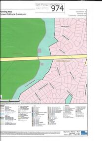
Map, Pioneer children's graves precinct, 1848-1860
Map showing the location and surrounds of Pioneer Children's Cemetery on the Plenty River in Greensborough. Children from pioneer families are buried here.Official government planning map for the Pioneer Children's Graves Precinct.Printed coloured copy of map of Plenty River areapioneer childrens cemetery, greensborough, partington, whatmough -
 Bendigo Military Museum
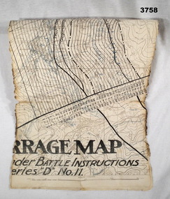
Map - TRENCH MAP WW1, Possibly 1918
Villeret is centred within the areas of Rosiel, Bony, Bellicourt and Bellenglise. The map is possibly when the advance was into the Hindenburg Line in late 1918. Item re William Alexander No 502 AIF. Refer Cat No 3746.3 for his service details.Map, small section of a “Barrage map” showing objective lines with distances, enemy trenches are in blue. Top half and bottom half of the map are missing. Area covered appears to be “Villeret” scale 1:20,000map, trench, barrage -
 Melbourne Tram Museum
Map, Metlink, "Your Guide to Melbourne's Public Transport System - City of Manningham", "City of Moonee Valley", c2005
... Maps ...Map - 18 fold - 6x3 - pocket size, printed in full colour, titled "Your Guide to Melbourne's Public Transport System - City of Manningham", published by Metlink c2005. Has a map of transport routes in the City of Manningham, details of Metcards, bus routes, maps of the tram and train network and Metcard agents. .2 - as for .1, but for the City of Moonee Valleytrams, tramways, maps, city of manningham, city of moonee valley -
 Marysville & District Historical Society
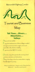
Map (Item) - Tourist and business map, Narbethong Community and Tourism Group, Narbethong Buxton Taggerty Tourist and Business Map, 04-2008
A tourist and business map of Narbethong, Buxton and Taggerty. This map was produced by the Narbethong Community and Tourism Group in April 2008. It was produced to promote the natural attractions, adventure activities and food trail from the Black Spur, through Narbethong, Buxton and Taggerty.A tourist and business map of Narbethong, Buxton and Taggerty.This publication has been produced by the Narbethong Community and Tourism/ Group (NCTG) to promote the natural attractions, adventure activities and food/ trail from the Black Spur, through Narbethong, Buxton and Taggerty./ the information provided in this publication has been supplied by the individual/ members. NCTG takes no responsibility for its accuracy./ April 2008narbethong, buxton, taggerty, victoria, australia, tourist and business map, narbethong community and tourism group, acheron valley, yarra track, wood's point, black spur, mystic mountains, the meeting of the waters, cathedral range, danico design counted cross stitch, things of sand & stone, buxton zoo nursery & oddz & enz, willowbank at taggerty, safe trek 4wd services, pnl 4wdriving, buxton trout and salmon farm, mystic mountains ski hire & outdoors, narbethong ski hire, highwood health centre, cathedral view natural therapies, narby cabinets, plants by shelian, gb timber, executive signs, rb automotive repairs, buxton car care, marysville towing & equipment hire, martyn slade building design, cathedral peak framing, black spur roadhouse & ski hire, tudor lodge roadhouse & ski hire, buxton roadhouse & persian bazzar, buxton post office general store & niche bar, igloo roadhouse, taggerty store, narby eggs, marapana agistment park, mantirri blueberry farm, carmyle farm, hazelwood hazelnuts, south cathedral lavender farm, cathedral cherries, black spur motel & caravan park, woodlands rainforest retreat, chestnut glade, black spur inn, wombat cottage, abbey lake luxury b & b spa cottages, blue views holiday cottages, camp narbethong, marapana farm stay b & b, mantirri blueberry farm b & b, little dene garden cottages, silverstream b & b cottages, nareen cabins, moondai farm b & b, south cathedral farm luxury b & b cottages, yarrolyn caravan park, sarsens rest, lomah retreat, pinjarra gardens, kingbilli country estate, henry viii manor house, buxton hotel, butters cafe of buxton, wagtail wines, little river wines, lanterns at willowbank, wirrawilla rainforest walk, wilhemina falls, the cascades -
 Marysville & District Historical Society
Map (Item) - Tourist and business map, Narbethong Community and Tourism Group, Narbethong Buxton Taggerty Tourist and Business Map, 04-2008
A tourist and business map of Narbethong, Buxton and Taggerty. This map was produced by the Narbethong Community and Tourism Group in April 2008. It was produced to promote the natural attractions, adventure activities and food trail from the Black Spur, through Narbethong, Buxton and Taggerty.A tourist and business map of Narbethong, Buxton and Taggerty.This publication has been produced by the Narbethong Community and Tourism/ Group (NCTG) to promote the natural attractions, adventure activities and food/ trail from the Black Spur, through Narbethong, Buxton and Taggerty./ the information provided in this publication has been supplied by the individual/ members. NCTG takes no responsibility for its accuracy./ April 2008narbethong, buxton, taggerty, victoria, australia, tourist and business map, narbethong community and tourism group, acheron valley, yarra track, wood's point, black spur, mystic mountains, the meeting of the waters, cathedral range, danico design counted cross stitch, things of sand & stone, buxton zoo nursery & oddz & enz, willowbank at taggerty, safe trek 4wd services, pnl 4wdriving, buxton trout and salmon farm, mystic mountains ski hire & outdoors, narbethong ski hire, highwood health centre, cathedral view natural therapies, narby cabinets, plants by shelian, gb timber, executive signs, rb automotive repairs, buxton car care, marysville towing & equipment hire, martyn slade building design, cathedral peak framing, black spur roadhouse & ski hire, tudor lodge roadhouse & ski hire, buxton roadhouse & persian bazzar, buxton post office general store & niche bar, igloo roadhouse, taggerty store, narby eggs, marapana agistment park, mantirri blueberry farm, carmyle farm, hazelwood hazelnuts, south cathedral lavender farm, cathedral cherries, black spur motel & caravan park, woodlands rainforest retreat, chestnut glade, black spur inn, wombat cottage, abbey lake luxury b & b spa cottages, blue views holiday cottages, camp narbethong, marapana farm stay b & b, mantirri blueberry farm b & b, little dene garden cottages, silverstream b & b cottages, nareen cabins, moondai farm b & b, south cathedral farm luxury b & b cottages, yarrolyn caravan park, sarsens rest, lomah retreat, pinjarra gardens, kingbilli country estate, henry viii manor house, buxton hotel, butters cafe of buxton, wagtail wines, little river wines, lanterns at willowbank, wirrawilla rainforest walk, wilhemina falls, the cascades -
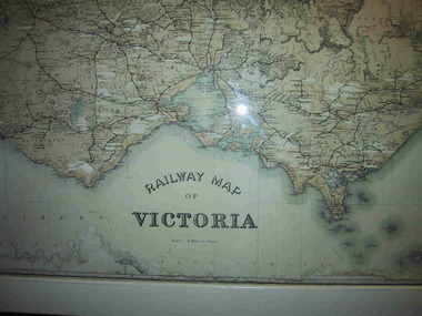 Parks Victoria - Mount Buffalo Chalet
Map, "Railway Map of Victoria"
Large framed map of Victoria, showing Victorias extensive rail network. Printed by Victorian Railways and is one of a number of 'framed pictures, particularly photographs of scenery, which have always been a feature of the Chalet.' (Pg 83. Historica, 2011) This map has been a permanent fixture situated in the hallway alongside the ballroom leading to the ski hire area since the 1950's and most likely earlier. Listed in Draft Inventory of Significant Collection ItemsLarge railway map of Victoria, Melbourne & Ballarat framed in white painted wood. Scale eight miles to one inch. Areas of the map have been whited out.Yes -
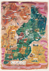 Eltham District Historical Society Inc
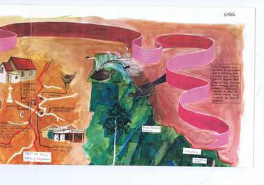
Map (item), Megan Evans, Cultural Heritage Map, Shire of Eltham, 1993
Copy of artist's map of the Shire of Eltham with numerous historical and cultural places of interest illustrated and notated including evidence of original Wurundjeri occupation and local flora and fauna. The original watercolour is held in the Nillumbik Shire Council Civic Collection. "Evans remembers being surprised they had asked an artist to create this map rather than a designer. Originally made as a watercolour, the map was later made into posters and adorned many homes around the area. The map creatively interprets the town and provides a wayfinding to both cultural and historical points in the area." Nillumbik Arts News December 2023. artist, buildings, cultural heritage map, fauna, flora, map, megan evans, shire of eltham, wurundjeri -
 Greensborough Historical Society
Map, U. M. Woods, Map of Greensborough early to mid 1950s, 1839-1959
Map of Main and Grimshaw Streets Greensborough by U.M. Woods. Properties shown are drawn from memory and represent the town in the early to late 1950s.Sketch map, black on white paper. letter of explanation.u. m. woods, grimshaw street greensborough -
 Bendigo Military Museum
Map - MAP, RAVENSWOOD, VIC TRAINING AREA, Aust Army
Items in the collection re Lt Col J. Swatton, refer Cat No 6719.2P for his service details.This is an enlarged version of a contour map. It is undated. On centre left is Ravenswood Train station. The Calder Highway is shown, from the bottom of the map to halfway up left side. Top right side shows "Spring Hill".Each grid square is 1000 x 1000 yards. Top right corner grid is 230,000 E, 450,000 Nth. Magnetic variation when this map was made is 6.55' grid to magnetic Nth. printed onto the map, with an "X" are 'Starting Point', "Debussing Point", and "Assembly Point" . Handwritten in red pencil at top LHS are the letters "C.O".passchendaele barracks trust, map, j.w. swatton -
 University of Melbourne, Burnley Campus Archives
Plan, Aberfeldie, Trawalla, 1905
Photocopies of plans of 2 adjoining house and garden sites in Toorak, Victoria, 'Aberfeldie' and 'Trawalla'. Handwritten, "Map 937a, Map 937b 'Trawalla', Map 937c, Map 937d."aberfeldie, trawalla -
Port Melbourne Historical & Preservation Society
Map - MMBW Map Area No 56, after 1911
The map is based on the 1894 MMBW map (Cat No 271) but shows buildings that were constructed after this date. In particular houses in Bridge Street between Williamstown Road and Derham Street, buildings between the right of way and Derham Street and Williamstown Road including an A T Harmon building constructed in 1911. There are also houses at the top end of Derham Street near Williamstown Road.Photocopy of a section of a larger MMBW map created after 1911.engineering - board of works, built environment, alfred thomas harmon -
 Bendigo Military Museum
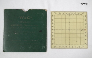
Equipment - PROTRACTOR, SQUARE
... maps ...Item re Frederick Gardner DAVEY DFC No 410533. Refer Reg No 3536P for his service details. Used in map reading & air navigation. .1) Square green coloured card pocket for storing protractor / rule. Instructions for using the protractor / rule printed on reverse of pocket. .2) Combined protractor & rule. Square clear plastic with degrees markings around the outer edge. North marked in red. Centre area gridded in one centimeter squares..1) Printed on front: W & G DOUGLAS COMBINED PROTRACTOR AND PARALLEL RULE .2) Handwritten in pencil on back: 410533 DAVEY F.G.navigation, maps, equipment -
Beechworth Honey Archive
Map- Yackandandah
(2x) Map centred on Yackandandah, showing Myrtleford- Yackandandah Rd, Mt Stanley + Mt Big Ben. Scale 1:50,000. Paper white on back, yellow on front.Albury series R625 Blue ink marked '74-75' on top of one map.map, yankandandah, paper, beechworth honey -
Clunes Museum
Map (item), Dept. of Mines, Untitled, c1859
All maps show names and locations of mines operating in the district (see reference section link to article).1 360 Scale 1:2500 .2 303/59 33 hand written in ink "received 15 October 1859" signed by R Broughton, James Stevenson - District Mining Surveyor .3 40 chains to an Inchgold mining, dept of mines -
 Otway Districts Historical Society
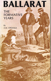
Book, B. & B. Strange, Ballarat: the formative years, April 1982
From 1838 early Ballarat was settled by pastoralists in ideal conditions, a peaceful, verdant valley where the hills were clothed in virgin forest and the flats covered with lush pasture. Then gold was discovered to spark off what was Victoria's first great gold rush. This book covers the gold rush after on the aboriginal ownership and early pastoral activities.Ballarat: the formative years. A.W. Strange. B. & B. Strange; Ballarat (Vic); April 1982. viii, 100 p.; illus.; map. Soft cover. ISBN 0 9596802 3 3Signed: "A.W. Strange 10/1/1983" Map inside back cover.ballarat; pastoralism; aborigines; gold rush; mining; eureka; local government; a.w. strange; -
Whitehorse Historical Society Inc.
Map, Melbourne Metropolitan Planning Scheme. Map No 39, c1950
... maps ...Map of central Melbourne showing planning zones with gardens and principal buildings marked.Map of central Melbourne showing planning zones with gardens and principal buildings marked.Map of central Melbourne showing planning zones with gardens and principal buildings marked.maps, city of melbourne, city of fitzroy, city of south melbourne, city of collingwood -
 Queenscliffe Maritime Museum
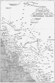
Map - B & W coastal map between Hervey Bay & Whitsunday Island, in Queensland, Coastal map, Queensland, between Whitsunday Island & Hervey Bay, Before donation in 1987
Australian coastal mapsAustralian coastal mapsCoastal 'soundings' map between Hervey Bay & Whitsunday Island, in Queensland, from an unknown book, pre-1987Reverse " NIL "old maps of australian coast -
 Queenscliffe Maritime Museum
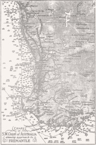
Map - B & W coastal map, Fremantle & SW Coast, Western Australia, Coastal map of SW Coast of Australia & the approach to Fremantle WA, Before donation in 1987
Australian coastal mapsAustralian coastal mapsB&W Coastal map of SW Coast of Australia & the approach to Fremantle WA, from an unknown book, c1864.Reverse " NIL "old maps of australian coast -
 Wodonga & District Historical Society Inc
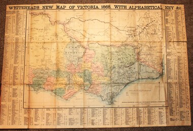
Map - Whiteheads New Map of Victoria, E. Whitehead & Co., engravers & lithographers, 1868
Edward Whitehead was a printer and publisher active in Melbourne during the latter half of the 19th century. Whitehead founded his printing business at 67 Collins Street East in 1864 and, though not focused on maps, began publishing his own series of maps of Victoria in 1867. He focussed on producing highly detailed folding maps of Victoria which included a very detailed index of place names. His series of maps of Victoria became one of the most successful and most profitable series of regional maps of Australia ever produced.This is a very early map of Victoria showing Belvoir (Wodonga)A detailed early map of Victoria with counties clearly marked and shaded and a detailed index. It also shows roads, post office towns, railways, telegraphs, gold mining areas and notes on topography. Relief shown by hachures and spot heights. Includes a list of towns with distances from Melbourne on 3 sides of map. It is produced on paper mounted on linen.victoria cartography, rare maps victoria, whiteheads maps -
 Marysville & District Historical Society
Map (Item) - Tourist and business map, Narbethong Community and Tourism Group, the Gateway TOURIST AND BUSINESS MAP, 08-2009
A tourist and business map of Narbethong, Buxton, and Taggerty. This map was produced by the Narbethong Community and Tourism Group Inc in August 2009. It was produced to promote the natural attractions, adventure activities, and food trail from the Black Spur, through Narbethong, Buxton, and Taggerty.A tourist and business map of Narbethong, Buxton and Taggerty.This publication has been produced by the Narbethong Community and Tourism Group Inc./ (NCTG) The information provided in this publication has been supplied by the individual/ members. NCTG takes no responsibility for its accuracy./ August 2009narbethong, buxton, taggerty, victoria, australia, tourist and business map, the gateway tourist and business map, black spur motel & caravan park, woodlands rainforest retreat, chestnut glade, black spur inn, wombat cottage, abbey lake luxury b&b spa cottages, camp narbethong, marapana farm stay b&b, mantirri b&b, little dene garden cottages, nareen cabins, silverstream b&b cottages, buxton hotel motel, south cathedral farm luxury b&b cottages, cathedral view b&b retreat, kingbilli country estate, cathedral valley farm, pinjarra gardens, willowbank at taggerty, sarsens rest, yarrolyn caravan park, danico design counted cross stitch, things of sand & stone, buxton zoo nursery, safetrek 4wd services, mystic mountains ski hire & outdoors, pnl 4wdriving, buxton trout and salmon farm, buxton bait and tackle, black spur roadhouse, tudor lodge service station roadhouse & ski hire, buxton roadhouse, buxton p.o. general store, igloo roadhouse, henry v111 manor house, buxton hotel, butters cafe, wagtail wines, little river wines, narby eggs, marapana agistment park, carmyle farm, hazelwood hazelnuts, cathedral view naturall therapies, cre8ing growth, linda hailey, naby cabinets, gb timber, narbethong timber & trading, rb automotive repairs, buxton car care, martyn slade building design, taggerty vet clinic -
 Greensborough Historical Society
Map, Cultural heritage Map Shire of Eltham, designed and painted by Megan Evans, 1993_
An annotated map of the Shire of Eltham showing places of interestColoured map, folded four times, annotated with historical notes and descriptions of physical and natural featuresshire of eltham -
 Greensborough Historical Society
Map, Municipality of Heidelberg Plan No. 480, 17/10/1948
Map shows streets, buildings, river and major drainage easements in area covered by West boundary Sellars Street, North boundary Yando Street & South boundary Grimshaw Street. Adjoins Map No. 481 to East. Black & white map, features marked in green, gradients in red. Scale: 160 feet to 1 inchgreensborough -
Whitehorse Historical Society Inc.
Map, Today's map of Mitcham, Nunawading, Blackburn, 1957
... Maps ...Folded detailed map of Mitcham, Nunawading, BlackburnFolded detailed map of Mitcham, Nunawading, BlackburnFolded detailed map of Mitcham, Nunawading, Blackburnmaps, mitcham, nunawading, blackburn, burwood east, forest hill, vermont -
Clunes Museum
Map, 1962
... maps ....1 &.2 MAP OF BALLARAT SHIRE GROUP RURAL FIRE BRIGADES FIRE CONTROL MAP. COMPILED BY C. H. FENTON. (2 COPIES) DETAILING SEALED ROADS, STATE FORESTS, PINE PLANTATIONS, FOREST AREAS, RAILWAYS, BOUNDARIES, TOWNSHIP AREAS CEMETERIES, CREEKS, SWAMPS AND HOUSES.local history, document, maps, fire brigade -
 Beechworth Honey Archive
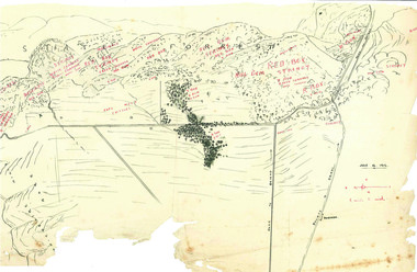
Hand-Drawn Map Centred on Buckland Gap Road by Frank Lebbell Frost July 1916
This is one of the maps drawn by Frank L. Frost while he was beekeeping in North-East Victoria. This particular map may be reference in the "Wooden" Diary on page 8.Hand-drawn map centred on Buckland Gap road (near Murmungee). Details the quantity and quality of flowering timber in the nearby State Forest. Scale is 1/2 mile to 1 inch. Map was drawn on the 16th July, 1916. Drawn with black pen and grey lead on paper. Features are marked in red.hand drawn, hand-drawn, map, buckland gap, frost, beekeeper, beechworth honey -
 City of Kingston
Pamphlet - Colour, Stillwell and Co, The Hill Estate Highett Great Subdivisional Auction Sale, 1917
Sales plan for land in the suburb of Highett, bounded by Point Nepean Road and incorporating Sandford Street, Turner Road, Alfred Street, Peace Street and Tennyson Street. .The developing urban area of Highett within the City of Kingston. This land sale pamphlet illustrates the subdivision of land within the municipality and the changing demographic of the district as new houses are constructed.Colour pamphlet advertising subdivisional auction sale of the Hill Estate Highett. Incorporates a map of the estate bordered by Point Nepean Road and encompassing Sandford Street, Turner Road, Alfred Street, Peace Street and Tennyson St. Handwritten in grey pencil on reverse: Hill Street / Jamieson Handwritten in blue pencil on reverse: The Hill Estate Handwritten in blue pencil on subdivision map: [tick] [on majority of properties marked on map]highett, land sales, estate -
 Melbourne Tram Museum
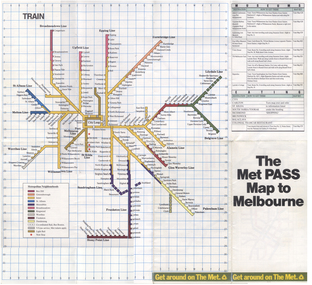
Map, The Met, "The Met PASS Map to Melbourne", c1988/90
... Maps ...Folded Map of Melbourne Rail and Tram lines, titled "The Met PASS Map to Melbourne" Tram Map - probably soon after conversion of the St Kilda and Port Melbourne lines to Light Rail, though these are not shown. Opened November 1987. Rail Map - shows Route 96 north section as Light Rail, co-ordinated bus routes, and the Altona line as going to Werribee. This route was opened in 1985. Date of Map c1988/1990. Has details of Museums, Art Galleries, Shopping, Gardens and Sports Arenas. See also Reg Item 379 for a similar item.trams, tramways, the met, melbourne, maps, tourist tickets -
Whitehorse Historical Society Inc.
Map, Blackburn East Primary School
Proposed master plan 1955?Proposed master plan 1955? With Public Works Dept. detail survey 1979. Rolled map.Proposed master plan 1955? blackburn east primary school no. 4800, public works department -
 Beechworth RSL Sub-Branch
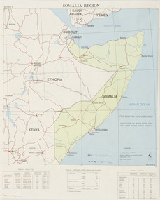
Map - Map Somalia Region, 1992
This map was used for briefing purpose only as the relief data is incomplete. Double sided coloured paper map of the Somalia Region with a 1:2 250 000 scale. Display side - PRODUCED AND PRINTED BY / 1 TOPO SVV SQN / ROYAL AUSTRALIAN SURVEY CORPS / DECEMBER 1992 DEF/ARMY 20463 / -
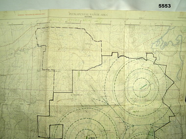 Bendigo Military Museum
Map - MAP of PUCKAPUNYAL, RAAF et al, 1958
Refer to Cat 5547, Matheson.This is a large map, printed in colour on one side only. Scale 1:25,999. The grid squares are 1000 x 1000 metres. it shows the camp, ranges and bush areas used by the military.This map is covered in a large number of added colour shadings, nav lines, airstrips and circles.puckapunyal army base, military training, map