Showing 1295 items matching "mitchell street"
-
 Glenelg Shire Council Cultural Collection
Negative - Negative - Isle of Bags' Nelson, Victoria, c. 1936
Transparency for black and white photo. 'Isle of Bags' Nelson Vic. Major Mitchell cairn erected in middle of 'island' (1936 -
Glenelg Shire Council Cultural Collection
Functional object - Calligraphy Nibs - William Mitchell's Decro Pens, n.d
White card with black print, space for 9 calligraphy nibs, but 3 missing -
Glenelg Shire Council Cultural Collection
Programme - Programme - Major Mitchell 150th celebrations 1986, Exchange Printers, Mt. Gambier, n.d
Major Mitchell 150th celebrations, 31 Oct - 9th Nov 1986A4 DL Flyer, programme for Major Mitchell 150th celebrations, 31 Oct - 9th Nov 1986, at Dartmoor and District. White paper, red print and depiction of Major Mitchell on front. -
Glenelg Shire Council Cultural Collection
Photograph - Photograph - Tree Planting, n.d
Sourced from Casterton Town Hall (Former Shire of Glenelg)Black and white photo. Five Shire of Glenelg Councillors, planting tree in memory of Dame Mary GilmoreBack: 'Crs. J. Little, - Waltham, J. Clarke, D. Mitchell, N. McLeod Secretary planting Dame Mary Gilmore Tree', handwritten in blue biro. Round, purple, photographer's stamp. -
Glenelg Shire Council Cultural Collection
Photograph - Photograph - Councilor D.P Mullane, c. 1963
Sourced from Casterton Town Hall (former Shire of Glenelg)Black and white photo. Cr. D.P. Mullane sitting in large chair, behind a desk. Velvet drapes in background. Hands crossed. Council chambers, Casterton Town Hall.Back: Black stamp '003635' "Exactly the same size as Cr. Mitchell" - handwritten, blue biro Blue biro line arrowed each end drawn across photo. '3" ' above line "Foreword" 3 1/2 Cr. D.P. Mullane Shire President 1962/3 1/4 Black E' - pencil -
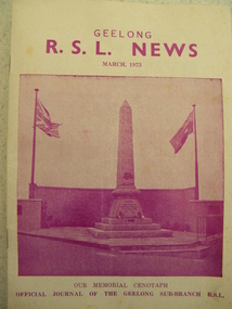 Geelong RSL Sub Branch
Magazine, Henwood & Dancey Pty. Ltd, Geelong RSL News March 1973, March 1973
This Magazine was compiled and issued by the Geelong RSL in March 1973.This is an original magazine. The magazine is a collection of stories and club information relating to the 'times'.An oblong booklet, paper pages with purple typed stories there is a photograph of the Cenotaph on the front cover.Published by Geelong RSL, G A Mitchell, Secretary Printed by Henwood & Dancey Pty. Ltd., 54-58 Little Ryrie Street, Geelonggeelong rsl news march 1973 -
 Dunkeld Museum Inc.
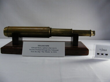
Telescope, Unknown, 18th century
Believed to be Edward Henty's telescope which was used at the early settlement at Portland and used to observe movements of ships at sea. Believed to have come off the boat "The Thistle"Found, stored in a thermos which was purchased in a box of sundries at a clearing sale at the Henty property.Brass telescope, made in 4 sections plus the eye piece. Eye piece has a slideable cover to protect the lens. Removeable lens.None from manufacture however there are scratched markings inside the eyepiece but are no longer readablehentys, expolration of victoria, telescope, major mitchell -
Glenelg Shire Council Cultural Collection
Souvenir - Envelope and Brochure - Major Mitchell Celebrations 1986, n.d
a. White envelope, postmarked 'Dartmoor 7 Nov. '86' 'Major Mitchell Celebrations 1836 -1986 DARTMOOR VIC 3304 and depiction of Major Mitchell. Top left: Depiction of mail horse and cart, bottom left. 'Historic Mail Service by Horse and Cart' underneath b. DL Flyer, with history and programme for re-enactment of horse and wagon mail and freight run Heywood to Dartmoor 6/7 Nov 1986 inside (a)celebration, centenary, major mitchell -
Glenelg Shire Council Cultural Collection
Souvenir - Sticker - Casterton, n.d
Green and white shield shaped vinyl sticker; depictions of kangaroo and emu; green print 'CASTERTON' on top edge; 'HENTY & MITCHELL COUNTRY Victoria' on lower. Mounted on white card.souvenir, casterton -
Glenelg Shire Council Cultural Collection
Photograph - Photograph - Shire of Glenelg Councillors, c. 1963
Sourced from Casterton Town Hall (Former Shire of Glenelg)Black and white photo. Three councillors for the Central Riding, Shire of Glenelg 1962/3, sitting behind desk, Honour Board on wall behind them, with names of Past Presidents of the Shire of Glenelg, 1863 - 1963 Left to right: H. D Mitchell, J.J. Howlett, J. R Hargreaves Council chambers, Casterton Town HallBack: Black stamp '003635. Letter 'A' heavy pencil. Blue biro line, arrowed each end, drawn across photo. '3" ' above line. 'Councillors central Riding 1962/3 '1/4 black' -pencil L to R Cr H.D. Mitchell Cr. JJ. Howlett Cr. J.R. Hargreaves' - handwritten pencil -
Glenelg Shire Council Cultural Collection
Photograph - Photograph - Meeting of Viscount de Lisle, Governor General of Australia and Cr. H. D. Mitchell, Shire President, 25/10/1963
Sourced from Casterton Town Hall (former Shire of Glenelg)Coloured photograph of Viscount de Lisle, Governor General of Australia, being greeted by Cr. H. D. Mitchell, Shire President, at Casterton Town Boundary, on 25th Oct. 1963. The photograph is in a cream folder, with green manufacturer's information -
Glenelg Shire Council Cultural Collection
Souvenir - Pennant - Mitchell Portland High School team, n.d
Pennant / small flag on wooden stick. Red fabric, white lighthouse and ''MITCHELL' PHS house team -
 Halls Gap & Grampians Historical Society
Photograph - B/W, Oct-86
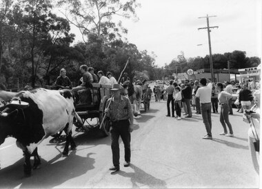
The bullock team was part of a parade held on the main street of Halls Gap in conjunction with the 150th anniversary of Major Mitchell's visit to the area. There was also a plaque unveiled in commemoration of the Wildflower Show and its many volunteers.The photo shows a crowd watching a bullock team hauling a dray with five children sitting in it down a road. The bullock driver is walking alongside holding a long handled whip over his shoulder. A wagon pulled by draught horses can be seen behind the bullock dray. Buildings can be seen to the right rear of the photo and trees line the left side of the street.events, parades -
 Halls Gap & Grampians Historical Society
Photograph - B/W, Oct-86
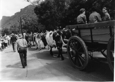
The bullock team was part of a parade held on the main street of Halls Gap in conjunction with the 150th anniversary of Major Mitchell's visit to the area. There was also a plaque unveiled in commemoration of the Wildflower Show and its many volunteers.The photo is taken from the rear of a bullock team pulling a dray down a road. Three children can be seen sitting in the dray and its back is out of shot. Two men are walking to the left of the team, the closest to the camera holding a long whip over his shoulder. To the far left people can be seen lining the street and in the right background a range of peaks can be seen.events, parades -
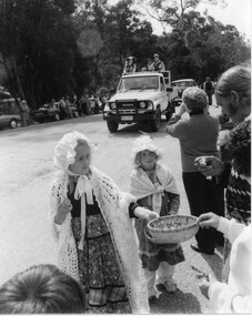 Halls Gap & Grampians Historical Society
Photograph - B/W, Oct-86
This is part of a parade held on the main street of Halls Gap in conjunction with the 150th anniversary of Major Mitchell's visit to the area. The photo shows two young girls wearing flower patterned dresses, frilly hats and shawls standing on the edge of a road. The front girl is offering flowers in a straw basket to people lining the street. A Toyota land cruiser with people dressed in what appears to be park ranger or scout uniforms standing in the tray is driving down the road and an old car can be seen behind that. People and cars line the far side of the road and trees can be seen behind them.events, parades -
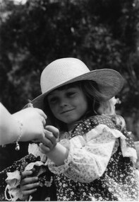 Halls Gap & Grampians Historical Society
Photograph - B/W, Oct-86
This is part of a parade held on the main street of Halls Gap in conjunction with the 150th anniversary of Major Mitchell's visit to the area. Thephoto is a close up of a young girl. She is wearing a broad brimmed straw hat and a flowery print dress with lace around the sleeves and a shawl lice cowl edged with lace. She is handing (or receiving) a flower to a woman, whose arm is the only part visible in the photo. The woman is wearing a bracelet with a heart shaped charm.events, parades -
 Halls Gap & Grampians Historical Society
Photograph - B/W, Oct-86
This is part of a parade held on the main street of Halls Gap in conjunction with the 150th anniversary of Major Mitchell's visit to the area. The photo shows three young girls and a dog standing as part of a crowd lining a street. Buildings , including a souvenier and newsagents and a cafe, can be seen behind the crowd. There are trees in the far background.events, parades -
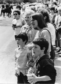 Halls Gap & Grampians Historical Society
Photograph - B/W, Oct-86
This is part of a parade held on the main street of Halls Gap in conjunction with the 150th anniversary of Major Mitchell's visit to the area. The photo shows a crowd of people lining a street. In the foreground there are two boys and a woman; one boy is holding a bucket of chips and the other is holding the woman's hand. In the background horses with riders can be seen on the street.events, parades -
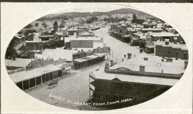 Ararat & District Historical Society (operating the Langi Morgala Museum)
Postcard
Black and white postcard of Barkly Street, Ararat. The photo is taken from the Town Hall. The Commercial Hotel and its balcony are pictured on the right while the zig zag of the main street looks like a dirt road.Addressed to Mr G. Mitchell, Collins St, Melbourne also a letter written on the back of the postcard -
 Eltham District Historical Society Inc
Photograph, Spring Excursion, Hume and Hovell bus tour Stage 2, Seymour, Benalla; 26 Oct 1997, 26/10/1997
MONUMENT HUNTING THE HUME AND HOVELL WAY (Newsletter No. 117, November 1997, by Diana Bassett-Smith) Sunday October 26 1997 dawned bright and very warm. Some twenty-five members, complete with picnic baskets, met outside the Eltham Library awaiting the Cobb and Co. large coach which would be taking us on the second leg of our travels along the route of the early explorers Hume and Hovell. Stephen West was our very good driver for the day. He would be guided around the circuitous route by Russell Yeoman wh9 had made a detailed study, not only of the intended route, but of the story of these two explorers. During the trip Russell regaled us with poetry, quotations from the Journals and the History of the Shire of Seymour, "The New Crossing Place: by Martindale, 1982, (now Mitchell Shire due to the recent amalgamations). We headed towards the Hume Highway via Greensborough and Cooper Street and proceeded north to our first stop, noting on the way Monument Hill in the distance which is near Kilmore and, according to Russell, well worth the effort to visit as the view across the valley is magnificent. Past Sunday Creek Valley, Mt Piper and Mt Disappointment, all traversed and noted and named by them. We passed through Tallarook, then onto Seymour where we took photos of the monument telling us that Hume and Hovell had passed through on the 28th of October 1824. We also deviated down Hume and Hovell Road viewing deer and emu farming and the Bellbourie property now a sanctuary. Leaving Seymour behind we travelled up the Avenel Road to the Avenel monument, pyramidal in design of four reducing square blocks with a sharply pointed peak, erected in 1924 in memory of the 1824 exploration. The day was warming up and the countryside showing the dryness of the current drought. A parallel note had been made in their journal too of 1824 of the drought appearance of the country they were traversing. At Seven Creeks, Euroa we stopped for some minutes to check the monument placed 20th November 1924 to commemorate their passage on the 29th December 1824. More photos. Russell had pointed out the abrupt termination of the distant ranges which is noted in their journal. The next monument is beside the road at the entrance to Honey Suckle Creek Caravan Park, Violet Town. The squarish shaped monument some eight feet high is topped with a simple steel cross, and was to mark the date of 28th December 1824 and built for the 20th November 1924. By now it was 12.20 and nearly lunchtime as we drove along the Warranbayne Road to Roach's Road, monument hunting without success. Though there is a large, what appears to be an old timber sign which was hard to read, maybe this was the lost monument. In many of the paddocks hay had been cut and baled or was being cut, what a contrast to the rugged country they had passed through which was smoky from the fires of the natives burning off By 1.00 pm we were at Benalla and pulled up beside the park where abundant beds of roses filled the air with their scent and the smell of barbecued food twitched the nostrils whilst the cheerful sounds of other picnickers could be heard throughout the park. We left the bus and collected up our picnics, dispersed to the various tables and enjoyed the shade from the various European trees. 2.00 pm and we were on the road again driving along the Benalla, Mansfield, Yea road. The Swanpool monument states that they passed four miles south and returned three miles north. Then we stopped at the Barjarg monument which notes that they camped near this spot. It is again a pyramidal monument and this time topped with a steel arrow indicating their route of the 29th November 1824. Half an hour later we came to another monument, again with a steel arrow marker on top and the plaque dated the 2nd of 12th 1824. Erected on the 12th of 12th 1924. "They blazed the way that we might inherit the land." Another square based and needle topped monument appeared at Yarck near Yea and this plaque records the date of 3 December 1824. Near McGuigans Road Russell related that the expedition had lost a dog but it had found them next day, the dog was apparently torn by a kangaroo. A short while later Russell reminded us here of the problems they encountered in crossing the Goulburn River near Molesworth where banks were high, water deep and wide. "Good coat of grass but quite dry due to drought". At Yea we stopped for afternoon tea and raided the last of our picnics and looked at the monument to their journey of 1824, situated at a corner of the gardens near the bowling green. No photo – we were out of film. We returned home via Kinglake West and Whittlesea past the Yan Yean Reservoir, not full. 5.00 pm back at Eltham we emptied out of the bus and everyone, including Joan Cole, collected their things, Joan also had the major souvenir of the day, a large carp she had picked up from the river bank, her cat was in for a great feast. The day was made so interesting by the informed commentary which Russell provided. His background knowledge of the route and nature of the journey could only have come from many hours of reading and driving the area. Thank you to Russell and to everyone who made the day so informative and pleasurable. Diana Bassett-Smith. Record of the Society's history of activities - Spring 1997 excursionRoll of 35mm colour negative film, 6 stripsFuji 200shire of eltham historical society, activities, pretty hill, seymour, benalla, hume and hovell, monuments -
 Eltham District Historical Society Inc
Photograph, Spring Excursion, Hume and Hovell bus tour Stage 2, Seymour, Benalla; 26 Oct 1997, 26/10/1997
MONUMENT HUNTING THE HUME AND HOVELL WAY (Newsletter No. 117, November 1997, by Diana Bassett-Smith) Sunday October 26 1997 dawned bright and very warm. Some twenty-five members, complete with picnic baskets, met outside the Eltham Library awaiting the Cobb and Co. large coach which would be taking us on the second leg of our travels along the route of the early explorers Hume and Hovell. Stephen West was our very good driver for the day. He would be guided around the circuitous route by Russell Yeoman wh9 had made a detailed study, not only of the intended route, but of the story of these two explorers. During the trip Russell regaled us with poetry, quotations from the Journals and the History of the Shire of Seymour, "The New Crossing Place: by Martindale, 1982, (now Mitchell Shire due to the recent amalgamations). We headed towards the Hume Highway via Greensborough and Cooper Street and proceeded north to our first stop, noting on the way Monument Hill in the distance which is near Kilmore and, according to Russell, well worth the effort to visit as the view across the valley is magnificent. Past Sunday Creek Valley, Mt Piper and Mt Disappointment, all traversed and noted and named by them. We passed through Tallarook, then onto Seymour where we took photos of the monument telling us that Hume and Hovell had passed through on the 28th of October 1824. We also deviated down Hume and Hovell Road viewing deer and emu farming and the Bellbourie property now a sanctuary. Leaving Seymour behind we travelled up the Avenel Road to the Avenel monument, pyramidal in design of four reducing square blocks with a sharply pointed peak, erected in 1924 in memory of the 1824 exploration. The day was warming up and the countryside showing the dryness of the current drought. A parallel note had been made in their journal too of 1824 of the drought appearance of the country they were traversing. At Seven Creeks, Euroa we stopped for some minutes to check the monument placed 20th November 1924 to commemorate their passage on the 29th December 1824. More photos. Russell had pointed out the abrupt termination of the distant ranges which is noted in their journal. The next monument is beside the road at the entrance to Honey Suckle Creek Caravan Park, Violet Town. The squarish shaped monument some eight feet high is topped with a simple steel cross, and was to mark the date of 28th December 1824 and built for the 20th November 1924. By now it was 12.20 and nearly lunchtime as we drove along the Warranbayne Road to Roach's Road, monument hunting without success. Though there is a large, what appears to be an old timber sign which was hard to read, maybe this was the lost monument. In many of the paddocks hay had been cut and baled or was being cut, what a contrast to the rugged country they had passed through which was smoky from the fires of the natives burning off By 1.00 pm we were at Benalla and pulled up beside the park where abundant beds of roses filled the air with their scent and the smell of barbecued food twitched the nostrils whilst the cheerful sounds of other picnickers could be heard throughout the park. We left the bus and collected up our picnics, dispersed to the various tables and enjoyed the shade from the various European trees. 2.00 pm and we were on the road again driving along the Benalla, Mansfield, Yea road. The Swanpool monument states that they passed four miles south and returned three miles north. Then we stopped at the Barjarg monument which notes that they camped near this spot. It is again a pyramidal monument and this time topped with a steel arrow indicating their route of the 29th November 1824. Half an hour later we came to another monument, again with a steel arrow marker on top and the plaque dated the 2nd of 12th 1824. Erected on the 12th of 12th 1924. "They blazed the way that we might inherit the land." Another square based and needle topped monument appeared at Yarck near Yea and this plaque records the date of 3 December 1824. Near McGuigans Road Russell related that the expedition had lost a dog but it had found them next day, the dog was apparently torn by a kangaroo. A short while later Russell reminded us here of the problems they encountered in crossing the Goulburn River near Molesworth where banks were high, water deep and wide. "Good coat of grass but quite dry due to drought". At Yea we stopped for afternoon tea and raided the last of our picnics and looked at the monument to their journey of 1824, situated at a corner of the gardens near the bowling green. No photo – we were out of film. We returned home via Kinglake West and Whittlesea past the Yan Yean Reservoir, not full. 5.00 pm back at Eltham we emptied out of the bus and everyone, including Joan Cole, collected their things, Joan also had the major souvenir of the day, a large carp she had picked up from the river bank, her cat was in for a great feast. The day was made so interesting by the informed commentary which Russell provided. His background knowledge of the route and nature of the journey could only have come from many hours of reading and driving the area. Thank you to Russell and to everyone who made the day so informative and pleasurable. Diana Bassett-Smith. Record of the Society's history of activities - Spring 1997 excursionRoll of 35mm colour negative film, 6 stripsFuji 200shire of eltham historical society, activities, pretty hill, seymour, benalla, hume and hovell, monuments