Showing 1733 items
matching mr hill
-
 Eltham District Historical Society Inc
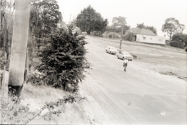
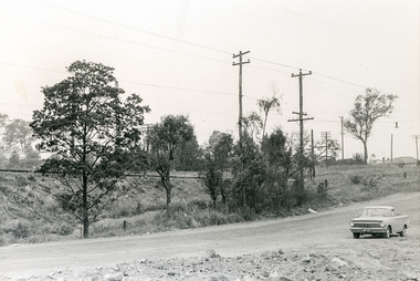
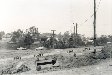
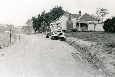
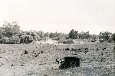
Photograph, Sherbourne Road, Para Road and Simms Road at Briar Hill/Montmorency prior to the upgrade of Sherbourne Road Railway bridge, c.1970
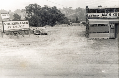
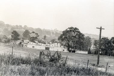
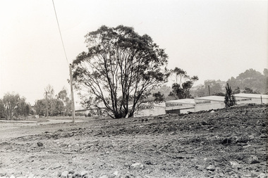
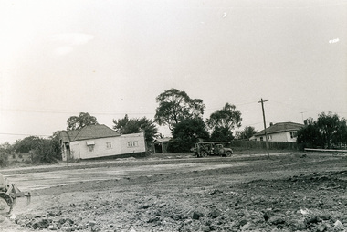
Collection of photographs probably taken around the same time depicting Sherbourne Road, Para Road and Simms Road at Briar Hill/Montmorency prior to the upgrade of Sherbourne Road Railway bridge, c.1970. Photo 01648_ 19 This home owned by Mrs Cameron. Her daughter married a Mr Davey, for whom Davey Road was named - email from M. Jones 20/07/2015 Photographer unknownThese photos are very significant in the documentation of the development of the Briar Hill and Montmorency areas and the changes in the physical landscape along the railway line area.20 black and white prints 9 cm x 13 cm.1970, briar hill, davey road, montmorency, para road, cameron, davey, sherbourne road, simms road, railway line, roadworks -
 Eltham District Historical Society Inc
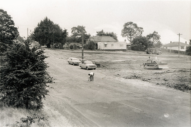
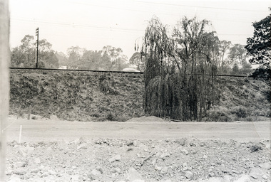
Photograph, Sherbourne Road, Para Road and Simms Road at Briar Hill/Montmorency prior to the upgrade of Sherbourne Road Railway bridge, c.1970
Collection of photographs probably taken around the same time depicting Sherbourne Road, Para Road and Simms Road at Briar Hill/Montmorency prior to the upgrade of Sherbourne Road Railway bridge, c.1970. Photo 01648_ 19 This home owned by Mrs Cameron. Her daughter married a Mr Davey, for whom Davey Road was named - email from M. Jones 20/07/2015 Photographer unknownThese photos are very significant in the documentation of the development of the Briar Hill and Montmorency areas and the changes in the physical landscape along the railway line area.20 black and white prints 9 cm x 13 cm.1970, briar hill, davey road, montmorency, para road, cameron, davey, sherbourne road, simms road, railway line, roadworks -
 Eltham District Historical Society Inc
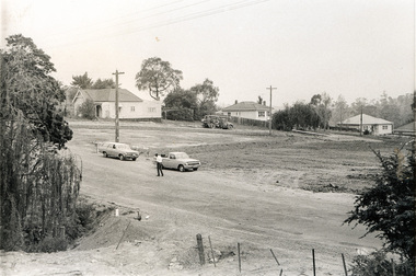
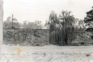
Photograph, Sherbourne Road, Para Road and Simms Road at Briar Hill/Montmorency prior to the upgrade of Sherbourne Road Railway bridge, c.1970
Collection of photographs probably taken around the same time depicting Sherbourne Road, Para Road and Simms Road at Briar Hill/Montmorency prior to the upgrade of Sherbourne Road Railway bridge, c.1970. Photo 01648_ 19 This home owned by Mrs Cameron. Her daughter married a Mr Davey, for whom Davey Road was named - email from M. Jones 20/07/2015 Photographer unknownThese photos are very significant in the documentation of the development of the Briar Hill and Montmorency areas and the changes in the physical landscape along the railway line area.20 black and white prints 9 cm x 13 cm.1970, briar hill, davey road, montmorency, para road, cameron, davey, sherbourne road, simms road, railway line, roadworks -
 Eltham District Historical Society Inc
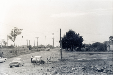
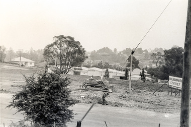
Photograph, Sherbourne Road, Para Road and Simms Road at Briar Hill/Montmorency prior to the upgrade of Sherbourne Road Railway bridge, c.1970
Collection of photographs probably taken around the same time depicting Sherbourne Road, Para Road and Simms Road at Briar Hill/Montmorency prior to the upgrade of Sherbourne Road Railway bridge, c.1970. Photo 01648_ 19 This home owned by Mrs Cameron. Her daughter married a Mr Davey, for whom Davey Road was named - email from M. Jones 20/07/2015 Photographer unknownThese photos are very significant in the documentation of the development of the Briar Hill and Montmorency areas and the changes in the physical landscape along the railway line area.20 black and white prints 9 cm x 13 cm.1970, briar hill, davey road, montmorency, para road, cameron, davey, sherbourne road, simms road, railway line, roadworks -
 Eltham District Historical Society Inc
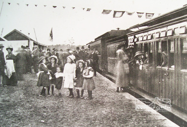
Photograph, Hurstbridge Railway Station, Opening Day, 25 June 1912
Despite inclement weather, up to 500 people attended the opening of the Eltham-Hurstbridge railway on 25 June 1912. Local member of parliament Ewen Cameron and Victorian Premier William Watt were present. Agitation for a railway extension began in 1888 when a meeting was held at Arthurs Creek to press for the construction of a railway line from Heidelberg to Kinglake. The Chairman Mr Charles Draper said this was necessary because this was the best fruit growing district in Victoria. Mr Cameron M.P. pointed out that whatever route the line took it would have to follow the Diamond Valley from Eltham. At the same time another meeting was pressing for the line to be extended to Queenstown (St Andrews). However when detailed surveys were made it was discovered that the only possible route was to Hurstbridge because of the hills. In 1912 the railway was opened terminating at Hurstbridge. Digital filerailway station, hurstbridge -
 Eltham District Historical Society Inc
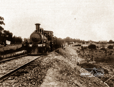
Negative - Photograph, Railway construction train hauled by steam locomotive W-197 between Eltham and Hurstbridge, c.1912
The locomotive was built by the American Baldwin Locomotive works in 1880 and was converted to a W class engine by the Phoenix Foundry at Ballarat in 1882. Agitation for a railway extension began in 1888 when a meeting was held at Arthurs Creek to press for the construction of a railway line from Heidelberg to Kinglake. The Chairman Mr Charles Draper said this was necessary because this was the best fruit growing district in Victoria. Mr Cameron M.P. pointed out that whatever route the line took it would have to follow the Diamond Valley from Eltham. At the same time another meeting was pressing for the line to be extended to Queenstown (St Andrews). However when detailed surveys were made it was discovered that the only possible route was to Hurstbridge because of the hills. In 1912 the railway was opened terminating at Hurstbridge. Roll of 35mm colour negative film, 4 stripsKodak Safety 5035steam train, w-197, railway construction, steam locomotive -
 Eltham District Historical Society Inc
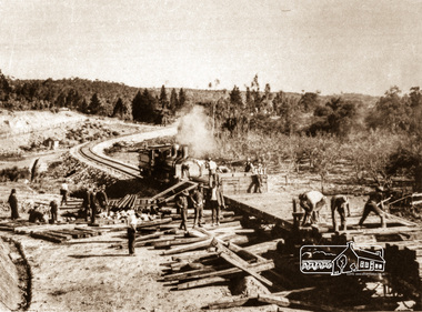
Photograph, Railway construction, Wattle Gen, c.1911-12
Agitation for a railway extension began in 1888 when a meeting was held at Arthurs Creek to press for the construction of a railway line from Heidelberg to Kinglake. The Chairman Mr Charles Draper said this was necessary because this was the best fruit growing district in Victoria. Mr Cameron M.P. pointed out that whatever route the line took it would have to follow the Diamond Valley from Eltham. At the same time another meeting was pressing for the line to be extended to Queenstown (St Andrews). However when detailed surveys were made it was discovered that the only possible route was to Hurstbridge because of the hills. In 1912 the railway was opened terminating at Hurstbridge. Roll of 35mm colour negative film, 4 stripsKodak Safety 5035steam train, railway construction, wattle glen -
 Eltham District Historical Society Inc
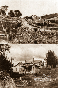
Negative - Photograph, Albert Jones, 'Golden Glen' at Wattle Glen and the Wattle Glen General Store, c.1910
Top photo: The property 'Golden Glen', home of photographer, Albert Jones. At the right of the photo is an apple orchard over the other side of Watery Gully creek. The middle building in the photo is still standing, located on Wattle Glen - Kangaroo Ground Road between Pretty Hill Lane and Millers Road (Melway 271 A6) but on the opposite side of the road. Bottom photo: The Wattle Glen General Store in this photo was located at the same intersection as the present Wattle Glen General Store (cnr of Reynolds Road and Kangaroo Ground Road) but on the diagonally opposite corner. [Comment from Valda via Victorian Collections June 11, 2018] "The addition to the store on the left, and the building at the back, were not part of the store/post office owned by the Keenan's. They were added by Mr and Mrs Alan (Janet) Frencham's in the ?mid-1950s." See also EDHS_03112: See Ref: EDHS_03112 A WINDOW ON THE PAST by Roger Sanders, The Sun, Wednesday, Auguist 11, 1976, pp 38-39 A fascinating window has been opened on the early life of the Eltham district. It is a rare collection of 3,000 perfectly preserved glass plate photograph negatives. The collection is the work of the late Albert Jones, a Diamond Creek orchardist and amateur photographer. About 500 of the negatives have been printed and 100 are on display at Gallery 4, Eltham, as part of the Eltham Festival," which started on Friday. They capture in fine detail rural and village life around Eltham, Hurstbridge, Kangaroo Ground, Yarra Glen and Diamond Valley from 1900 to 1930. While the natural beauty of the district was painted in this period by Arthur Streeton (later Sir Arthur), Tom Roberts and Charles Conder, among others, photography was relatively new. Yet Albert Jones used the new medium to compile a weighty album of pioneers at work, at home, at sport and on holidays. He was at the first Yarra Glen race meeting, early Diamond Valley football matches and photographed soldiers from the district leaving for war. He photographed early gold mines, men with horses laying the Diamond Creek-Hurstbridge rail track and the arrival of the first steam train at Hurstbridge. He took his cameras on holiday around Victoria and the collection includes scenes from St. Kilda and Portsea and many country towns. The Jones collection of negatives was found by Mr A. J. "Ned" Spark, of Balwyn, under a house he bought from Mr Jones' widow. The plates almost went to the tip with a pile of rubbish before Mr Spark realised their potential value. Mr Spark, who is retired, will continue the identification and recording of the photographs when he returns from holidays. The exhibition of the Jones' photographs is open each afternoon until August 21 at Gallery 4, 1016 Main Rd., Eltham. Photographs included in article: • The priceless collection of glass plate negatives were found under this house in Eltham [actually Wattle Glen], home of Albert Jones and his wife. • A quiet country pub - Panton Hills Hotel. • Teams of draught horses were used in the building of the Diamond Creek-Hursbridge railway in 1910. • Chinaman Jimmy using a gold cradle in Wattle Glen Gully. • The photographer and orchardist Albert Jones. His work is on show as part of the Eltham Festival • St Kilda Pier – several of the houses are still standing, but the waterfront has changed dramatically since this was taken before 1920. • A picnic was a dressy affair at the start of the century – the women in this family group are decked in lace and pearls.Roll of 35mm colour negative film, 4 stripsKodak Safety 5035albert jones, golden glen, shops, wattle glen -
 Eltham District Historical Society Inc
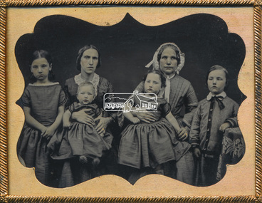
Photograph - Daguerreotype Photo Case, Members of the Hill family, early Eltham settlers, c.1860
Mrs Georgina Hill (wife of Henry), nee Reynolds (of Research, Vic.) in cap [possibly misidentified by donor - see note below] with Mrs Isaac Hill and her children (left to right) Amelia Hill, (born 1853) Mrs Isaac Hill with baby Isaac (born 1860, Eltham) on her lap. Mary Jane Hill (born 1857, Eltham) seated on Mrs Henry Hill's lap and Bob Hill. The Hill family were early settlers of the Eltham area. Daguerreotype photo enclosed in a leather bound clam shell box with felt lining and gold trim. Donated by Mrs Ivy Edna Hill, 4/1 Bridge Street, Eltham, 4 June 1966 and includes copy of her note identifying the people. Daguerreotypes were one of the first forms of early photographs. They initially appeared in Europe in 1839 and were produced in large numbers to the early 1850s but were superseded by more modern and flexible forms of technology by 1860. The photo was usually formed on a thin copper plate with light sensitve silver iodide. They have a mirror-like appearance and the image itself was mirrored. They were usually inserted into a case or frame made of wood bound in leather or velvet and cost about one guinea in Australia, the equivalent of a week's wages. With the advent of the gold-rush and growing population came an increase in numbers of photographers both studio and travelling. The daguerreotype process was protected by patents and could only result in a single image from which no copies could be made. With new technology involving wet colloidion glass plate negatives and albumen paper prints of which multiple copies could be produced at significantly reduced cost, the dauguerreotype quickly fell out of favour. An accompanying note with the photo written by Edna Hill of 4/1 Bridge Street Eltham dated 4 June 1966 states: "Dear Mr Watson, I think the enclosed old time photograph will be of interest to you. It would have been taken about 1860. The two ladies are the wives of the original pioneers of the Hill family. The one in the cap was the wife of Henry Hill, the other of Isaac Hill. The children are those of Mrs Isaac Hill, and grandchildren to Henry Hill. The little girl on the left is Amelia, the baby Isaac, the second girl is Mary Jane, and the boy on the right is Bob Hill. They grew up tobe Uncles and Aunts of my late husband. I greatly appreciated a letter received a few months ago per Cr Pelling, from the Shillinglaw Cottage Committee. Yours sincerely, Edna Hill" Victorian birth registrations show Mary Jane Hill was born 1857 in Eltham (9879 / 1857) and Isaac Hill at Eltham in 1860 (1972/1860) NOTE: Mrs Isaac Hill was Ellen Fitzsimons (1834-1863), mother to Henry Hill. Mrs Georgina Hill, wife of Henry cannot be the lady in the cap as she was not born till 1864. Georgina Reynolds (1864-1927) married Henry Hill (1862-1948) in 1884. This lady has significant wrinkling of the face, especially around her mouth. It is possible that she is the mother of Mrs Isaac Hill (Ellen Fitzsimons) who was Isabella Fitzsimons (nee Ferguson).Early pioneer settlers of ElthamAntique daguerreotypes in hinged gold frame, glass encased in a small clam-shell box lined with padded red felt and with catchamelia hill, bob hill, early settlers, eltham, hill family, isaac hill, mary jane hill, mrs henry hill, mrs isaac hill, daguerreotype, georgina hill (nee reynolds), research (vic.), sepp, shire of eltham pioneers photograph collection, women, ellen hill (nee fitzsimons), isabella fitzsimons (nee ferguson) -
 Eltham District Historical Society Inc
Photograph, Research Hotel, c.1910, 1910c
Black and white photograph postcardOriginally inscribed Kangaroo Ground hotel but crossed out and replaced with Research Hotel 1910 From Mr T. Scarse c/o Mrs T.M. jones "Coolibah" Cherry Tree Rd Panton Hill M59 -
 Eltham District Historical Society Inc
Photograph, Tom Prior, Bridge Street, Eltham
The house on the corner of Bridge and Susan streets was the home of Arthur Hill, nephew of Ivy Reynolds' father.The Reynolds family were early settlers in Research. The Reynolds/ Prior collection of photographs were taken by Tom Prior, the maternal uncle of Ivy Reynolds, around 1900 and the 60 photos in the album give a fine overview of many of the landmarks of Research and Eltham over 100 years ago. lvy lived in the family home for many years at 106 Thompson Cres Research. Ivy's father, Ernst Richard Reynolds and grandfather, Richard Reynolds, lived at the same address. Ivy's father Richard worked for Mr. Trail on his property in Research. Reynolds Road is named after the family. Mr Tom Prior (wife Eva) worked at the Melbourne zoo. He was very innovative and made his own camera, using the black cloth hood to exclude the light. The photographs are a reminder of the rural nature of Research and Eltham and its rich heritage. Black and white photograph mounted in an album, the Reynolds/Prior Photograph Collection, this being one of 53 reproduced black and white images of early Eltham.The Reynolds/Prior Photograph Collection, Presented to the Eltham District Historical Society, 14 June 2006 by Ross McDonald. A second copy was also presented to the Andrew Ross Museum, Kangaroo Groundarthur hill home, bridge street, eltham, reynolds prior collection -
 Kiewa Valley Historical Society
Photograph of Lake Guy and Bogong Village, Lake Guy and Bogong Village, Approx. 1945
In 1940 Field Headquarters for the Kiewa Scheme were established at Bogong with office, workshop facilities and accommodation for workmen, staff and some families constructed. (There had been a 'tent camp' on this site in 1939 but was destroyed by bushfires) Construction of accommodation continued until 1947. A total of 40 houses plus a hostel for single staff, post office, police station, medical centre and primary school all with water and sewerage and electricity supply. The staff hostel was known as Kiewa House and is now occupied by the Education Department. Lake Guy was named after Mr. L.T. Guy who was the Resident Engineer in charge of construction work and associated activities on the Kiewa area. He held this position from 1939 to November 1946 when he was transferred to Head Office.This photograph is an excellent historical record of Bogong Village in about 1945. It shows the layout of the town in the fairly steep terrain, the workmen's camp between the houses and the lake foreshore, the Commissioner's Lodge on the hill behind the Village, the walkway through the dam wall can be seen to the left of the spillway, the dam is on spill and note damage to the large trees is still evident from the 1939 bush fires. The Commissioner's Lodge was lost in the 2003 fires and the camp buildings were in service until 1962, when they were removed and the site converted into a public picnic area with lawns and gardens.A Black and white photograph"Lake Guy and Bogong" hand written on back of photograph.kiewa, accommodation, lake, dam, bogong -
 Kiewa Valley Historical Society
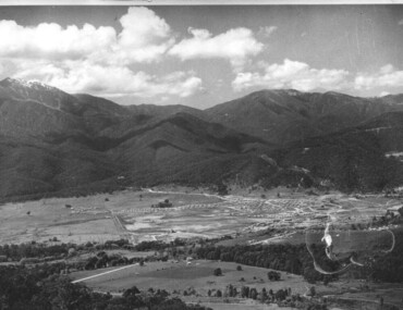
Photograph of Mt. Beauty, Mt. Beauty from transmission line, Approx 1950/51
This photo is of the very newly constructed State Electricity Commission town of Mt. Beauty. The houses up to Nelse street were erected from 1946 onward and then the township was extended beyond Nelse Street in 1950 which places this photograph about 1950/51. There is no evidence of work being commenced on the regulating pondage but the tail race canal can be seen on the centre right of photo. The workmen's camp was enlarged in 1950 to the extent of providing accommodation for a total of 1,200. There are a number of dwellings on Simmonds Creek and the road to Falls Creek can clearly be seen. Snow capped Mt. Bogong is in the upper left of the photo with Mt. Beauty behind the township rising to Big Hill beyond that.Shows the newly constructed town of Mt. Beauty surrounded by farmland and before the regulating pondage was built to discharge water from the power stations via the West Kiewa tail race tunnel into the Kiewa River. Black and white photographHand written on back of photograph "Mt. Beauty from Transmission Line"mt. beauty, construction, pondage, state electricity commission -
 Eltham District Historical Society Inc
Photograph, Entrance to Shire of Eltham Memorial Park, Garden Hill, Eltham-Yarra Glen Road, Kangaroo Ground, c.1923
View to south-east from Shire of Eltham Soldiers' Memorial Park showing the carriageway from the road to top of Memorial Park. Accompanying notes state that the entry gate was put in place in May 1921. Eltham and Whittlesea Shire Advertiser and Diamond Creek Valley Advocate Fri 21 May 1920 p 2 reported: Kangaroo Ground Memorial Park "It was decided to arrange for a working bee on Saturday, 29th inst., for the purpose of forming and gravelling the track leading to the Park, and of carrying out other necessary works." A history summary of the Shire of Eltham Soldiers’ Memorial Park • The summit at Garden Hill was a popular tourist lookout and picnic spot from the 1880s. Virtually the entire Shire of Eltham and beyond could be viewed from this location. • A local farmer, Mr Walter A. D. Wippell is credited as being the first to propose the idea of a war memorial park and offered £50 towards the purchase of the land. • The earliest public reference to this project is to be found in the local Advertiser newspaper edition of August 9th, 1918. A report of the August Council meeting records the Eltham Shire President, Cr. Robert White, saying: "some time back it was proposed that the Council obtain and place on an Honour Board in the Council Chamber [at Kangaroo Ground] containing names of the lads who had enlisted. Just recently however, it had been suggested that a more fitting memorial would be the obtaining of a piece of land on the summit of Garden Hill, Kangaroo Ground, and the formation of a memorial park in which a monument could be erected to represent the whole of Shire. If a couple of acres could be obtained a gentleman had promised to donate 50 pounds, and another one would fence it, and other contributions, he was sure, could be obtained." • Councillors were favourable of the proposal and the President, Shire Secretary and Shire Engineer were deputised to wait on Messrs Mess Bros. (the owners of the Garden Hill farm) and ascertain if they would gratuitously give the land. The Mess Bros. land adjoined the farm/stud of Mrs Fanny White (Cr Robert White’s mother), daughter of Andrew Harkness who established their property on Garden Hill around 1846. • Access to the land came in February 1919 when several Councillors and the Shire Engineer surveyed the actual two acres of '5 chains along the road and 4 chains deep'. The Engineer volunteered his services free to do this task. The Mess brothers however demanded £100 per acre but eventually agreed to take £50 per acre. • Entry from the Kangaroo Ground-Yarra Glen road was seen to be a problem and Mrs. White, who owned the land beside the park, was asked to donated a triangle of her property to allow this access. • By September 1919 returned soldiers were employed by the Shire and volunteers were called to clear the hilltop by ploughing up the rocks and clearing the area, the fencing was put into place and in May 1921 the Council erected three gates, within an archway, at the entrance to the drive and pathway to the summit. • Public subscriptions were sought through the Advertiser newspaper to beautify the site. The views of the Curator of the Melbourne Botanical Gardens were sought as to the ‘class of ornamental trees most suitable for planting in the Park area”. • The Memorial Park or Shire of Eltham Soldiers’ Memorial Park was officially opened by Mr. W.H. Everard, M.L.A., 3 September 1921. • In 1922 plans were made to place a War Memorial in the Park. Funds were donated by the Council of £250 and a challenge to the community, to match this money with contributions was met. • On Anzac Day 1923, 1,000 people gathered on the summit in the park for a memorial service. A much smaller group of about 50 people gathered around a newly constructed cairn and flagstaff in the afternoon of Anzac Day 1924 amidst rain and a squally southerly wind, the morning service being cancelled. • A meeting for those interested in establishing a War Memorial monument within the park was held in January 1924 and the Eltham Shire War Memorial League was formed and a design competition decided upon. • The Shire of Eltham War Memorial tower was built in 1926 at a cost of £1,023 and 5 shillings with locally quarried stone donated by Dr Ethel and Professor William Osborne. It was formally known as the ‘Shire of Eltham War Memorial’ and was unveiled on 11 November 1926. The large bronze inscription above the entrance to the tower states: SHIRE OF ELTHAM WAR MEMORIAL THESE MEN DIED FOR THEIR COUNTRY 1914 IN REMEMBRANCE THIS TOWER WAS BUILT 1918 • The Caretaker’s hut was built in 1927 with left over from the tower construction. • A returned soldier was appointed to act as caretaker for the memorials. Tiny Carrol, a huge man, was the first caretaker and lived in the stone hut. There was a push to have alterations made at one stage to provide additional rooms for a married caretaker but was rejected. • A new Caretaker Cottage was built in 1951 at a cost £2,500. The cottage had been subjected to raids by thieves three times during construction until a guard from the Returned Servicemen’s League was posted until its opening. • The War Memorial tower was re-dedicated by Sir Dallas Brooks on 8 November 1951, unveiling new bronze plaques containing the names of those who fell during the Second World War. Sir Dallas also officiated the opening of the new Caretaker’s Cottage. • A toilet block was built in 1965. • A further dedication of the Shire of Eltham War Memorial tower took place 11 November 2001 to recognise the men who fell in subsequent campaigns up to and including Vietnam. • Four land titles are involved: o The purchase of the two acres from owners Ruth Gosling, Alexander Mess, James Johnson Mess and Joseph Mess is recorded in two actions, the first being the payment of £100 for the two acres, the second showing that the Shire of Eltham did not get a transfer of title until 14th January 1952. o The access land donated by Mrs. Fanny White is dated 26 February 1924. A further need to widen the entry came after the deepening of the road cutting and another land donation was given by Sir Herbert Gepp, title dated 15th May 1952. This would have been about the time he sold off the former White ‘Garden Hill’ property. o The land reserve to increase the area and possibly allow a circuit road to be put in place on the western side of the park was purchased by the Shire of Eltham, title dated 16th February 1973. Rare photograph of the entrance to the Shire's Memorial Park during early stages of development prior to the erection of the Shire of Eltham War MemorialSepia photograph printed with white border with slight crack lower left hand corner and three significant vertical cracks fanning from lower centre edge to upper edge Digitally enhanced version to minimise impact of crackseltham-yarra glen road, entrance gate, garden hill, kangaroo ground, shire of eltham memorial park, shire of eltham war memorial, kangaroo ground war memorial park -
 Eltham District Historical Society Inc
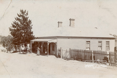
Photograph, Baker and Grocer shop, cnr. Main Road and York Street, Eltham, c.1902
Baker and Grocer store, cnr. Main Road and York Street, Eltham, early 1900s. Sign on side of building "Baker, Grocer & Summer Drinks" This image appears to be of the baker/grocery store after it was purchased in 1902 by Mrs Sarah Burgoyne and her husband, John James Thomas Burgoyne. It is possible that Mrs Sarah Burgoyne is the lady in front of the store with her eldest daughter, Charlotte and youngest son, James. Another daughter (Frances) and the family dog are watching from the doorway. In 1902 Mrs Sarah Burgoyne purchased from Wilfred Henry Johnston, the property on the southern corner of Main Road and York Street, Eltham, which consisted of a store and bakery establishment occupied by Mr. Luther Haley whose lease had expired around the same time. Mr. Haley had not been prepared to leave as he was unable to secure at Eltham a suitable house in which to carry on his business. Wilfred Johnston applied for an eviction of Hayley, which was heard at Eltham Courthouse in August 1902. Hayley advised he was building a place near the railway station which he expected to be done in about three weeks’ time. The court gave him the three weeks to vacate. Hayley’s new premises near the station became the present shopping district’s first shop and he ran it successfully till 1917 when the family moved to Clifton Hill, and he became a publisher. Their eldest child Leslie drowned in the Diamond Creek in early 1904, aged 12.Sepia photograph mounted on cardeltham, eltham bakery, grocer, john james thomas burgoyne, main road, sarah jane burgoyne (nee benson), summer drinks, york street -
 Eltham District Historical Society Inc
Folder, George Fletcher, 1878
Folder of information on George Fletcher, Councillor, Steels Creek, 1878. Fletcher, George, Yarra Flats was born in Herefordshire, England, in 1830, and came to Australia, landing in Adelaide, S.A. in 1851. A year afterwards he came to Victoria, but after visiting the Bendigo goldfields and other places returned to Adelaide. In 1859, he again came to Victoria, was employed on the View Hill station, Yarra Flats, and stayed there for four years. In 1867 he selected 80 acres under the Land Act of 1865, and afterwards an additional 320 acres on Steel's Creek, where he now carries on faming and dairying. During htis time Mr. Fletcher has been a member of the board of advice for the east riding of the shire of Eltham, and about twelve years ago he was elected a member of the shire council, and continued so for a term. Mr Fletcher was married in 1859, and has a family of four sons and four daughters. Fom "Victoria and its Metropolis: Past and Present" written in 1888 by Alexander Sutherland. Chapter 19, "The Upper Yarra District" pages [402] - 415. Includes descriptions of some townships and short biographies of local residents. Page 405 george fletcher, steels creek -
 Warrnambool and District Historical Society Inc.
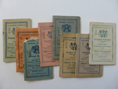
Document - Warrnambool. Woodford. Winslow. Purnim Race Books, Modern Print, W’Bool, Victoria, 1920's and 1930's
... on the property, “Green Hills” owned by Mr. John O’Keefe about one mile... on the property, “Green Hills” owned by Mr. John O’Keefe about one mile ...The Warrnambool Amateur Turf Club was first formed in September 1859, but didn't become a properly constituted club until April 1873, when a meeting was held at the Commercial Hotel, now the Whaler's Inn, and a committee was elected.Part of the present racecourse of 100 acres was set aside as a racing and recreation reserve in August 1855. It is one of the finest racecourses in Australia, ringed by the gentle slopes of a huge basin.The first race meeting was held on the course in August 1858. The Warrnambool Racing Club has managed racing at Warrnambool since it was formed on 5 April 1873.Apart from a number of smaller meetings held throughout the year, the feature of racing in the district is the Grand Annual Steeplechase. The first steeplechase over the now famous cross-country course was run on 13th June 1872 then known as the Grand Annual Steeplechase. The paddocks now know as Brierly and Granters were first used on that date. The course, over four miles, was made up of different kinds of jumps including a stone wall, a log fence, a ditch and parapet, a paling fence and numerous post and rails. The name Grand Annual was first used for this steeplechase in May 1895. It is the longest horse race in Australia, and the thirty three fences of the course, the most of any steeplechase in the world is raced over 5,500 metres. The three day May racing carnival is the major racing event on the horseracing and social calendar. Many of these race booklets relate to those May meetings. The Warrnambool Racecourse has been the home of district racing clubs such as Woodford, Purnim and Koroit over the latter part of the 20th century. The Woodford Racing club holds their annual meeting after Christmas each year. The Winslow races were held from approximately mid-19th century to around 1946. It began as a small picnic race club in Tobin’s paddock to a splendid race course on the property, “Green Hills” owned by Mr. John O’Keefe about one mile north of the Winslow township.. The annual meetings held on New Year’s Day drew crowds of seven to eight thousand people. All of these books contains family names which in some cases are still strongly linked to horse racing in the district.These booklets are a tangible link to a great sporting and social event in the Western District. A collection of programmes for race meetings. They relate to Warrnambool, Woodford, Purnim, Winslow and Victoria Racing Club meetings in the period 1922 to 1931. All are soft card covers with approximately 16 pages in each in white paper. They are numbered as follows: 001250.1 WRC Soft green cover with blue text 01/05/1923 001250.2 WRC Mauve cover with blue text 03/05/1923 001250.3 WRC fawn cover with red text 06/05/1924 001250.4 WRC Orange cover with blue text 08/05/1924 001250.5 WRC Soft green cover with light brown text 05/05/1925 001250.6 WRC Soft green cover with red text 07/05/1925 001250.7 WRC fawn cover with brown text 04/05/1926 001250.8 Woodford racing Club soft pink cover, Blue text 01/04/1922 001250.9 Woodford racing Club green cover, Blue text 07/04/1923 001250.9 Woodford racing Club grey cover, Blue text 05/04/1924 001250.10 Woodford racing Club grey cover, Blue text 05/04/1924 001250.11 Woodford Racing Club green cover, Blue text 22/11/1924 001250.12 Woodford Racing Club green cover, brown text 04/04/1925 001250.13 Woodford Racing Club orange cover, blue text 10/04/1926 001250.14 Woodford Racing Club pink cover, green text 10/04/1926 001250.15 Warrnambool Racing Club pink cover, blue text 18/11/1922 001250.16 Warrnambool Racing Club pink cover, red text 13/11/1926 001250.17 Warrnambool Racing Club cream cover, brown text 15/11/1924 001250.18 Warrnambool Racing Club cream cover, green text 18/01/1922 001250.19 Warrnambool Racing Club grey cover, blue text 15/01/1924 001250.20 Warrnambool Racing Club cream cover, blue text 13/01/1925 001250.21 Warrnambool Racing Club pink cover, blue text 15/01/1925 001250.22 Warrnambool Racing Club olive green cover, blue text 12/01/1926 001250.23 Warrnambool Racing Club blue cover, blue text 14/01/1926 001250.24 Warrnambool Racing Club soft green cover, blue text 13/01/1931 001250.24 Warrnambool Racing Club orange cover, black text 16/01/1930 001250.25 Warrnambool Racing Club orange cover, black text 16/01/1930 001250.26 Purnim Racing Club green cover, blue text 19/05/1924 001250.27 Winslow Racing Club pink cover,black text 21/04/1923 001250.28 Winslow Racing Club green cover,black text 06/12/1924 001250.29 Victoria Racing Club cream cover,green text 11/07//1923 001250.30 Victoria Racing Club cream cover, red text 14/07//1923 Most of the booklets have markings with place getters and jockeys marked in pencil. Warrnambool Racing club books have R U Forbes, C T Alexander A H Davies and William White as secretaries. Woodford club has Thomas Gleeson as secretary, Winslow 's secretary is W Latta and Purnim is P J Kelly. The local booklets are printed by The Modern Print Co Koroit St Warrnambool.warrnambool, warrnambool racing club, winslow racing club, woodford racing club, purnim racing club, victoria racing club -
 Warrnambool and District Historical Society Inc.
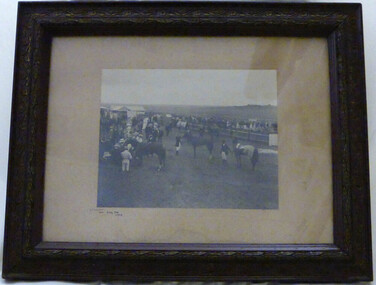
Photograph - Winslow Races 1912, Circa 1912
... Hills” owned by Mr. John O’Keefe about one mile north... paddock to a splendid race course on the property, “Green Hills ...The Winslow races were held from approximately mid-19th century to around 1946. It began as a small picnic race club in Tobin’s paddock to a splendid race course on the property, “Green Hills” owned by Mr. John O’Keefe about one mile north of the Winslow township.. The annual meetings held on New Year’s Day drew crowds of seven to eight thousand people. This photo provides a snapshot of one of the most important and well patronised events in the district. It is a very clear photo, providing evidence of racing operations and fashion of the day. Black and white photograph framed in brown engraved frame with fawn mount. Depicts a gathering of people and horses at race meeting. Winslow New Year’s Day 1912 written in black ink in bottom left corner of mount. Photographer’s name “Jordan Warrnambool,” embossed on bottom right hand corner.winslow, winslow racing club, jordan photographers -
 Emerald Museum & Nobelius Heritage Park
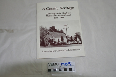
Book, A Goodly Heritage, A History of the Monbulk Methodist/Uniting Church 1893-1993, 1993
Methodist services began in late 1893 in the bush, near the end of the present Silvan Reservoir. The seats were split rails and the pulpit a fallen log with a sapling rail. Then a miner's bark hut became available in on the Recreation Ground. The Methodist Church was built and opened in 1903 on the corner of Moxham's Rd and David Hill Rd., with the financial assistance of Mr. James Griffiths of Griffiths Tea. This booklet gives a comprehensive history of the development of the church, its congregations and ministers.Soft cover booklet of 40 pages. Cream coloured cover with a photo of Monbulk Methodist Church 1972.monbulk methodist church, betty hotchin