Showing 1898 items
matching new north
-
 Mission to Seafarers Victoria
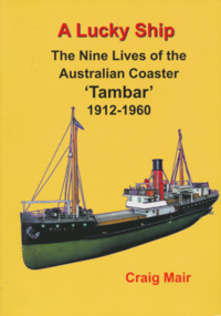
Book, Nautical Association of Australia Inc, A Lucky Ship – Nine Lives of Australian Coaster Tambar 1912-1960, 2013
This high-quality book is the extraordinary story of an ordinary little ship that had a long and eventful life. Perhaps few Australian coasters have had a more interesting and varied history. Built in Scotland in 1912 for the North Coast Steam Navigation Company, Tambar worked as a lifeline to isolated river and island communities, first in New South Wales, then for the Tasmanian Government and Holymans in Bass Strait (King Island) and as the last steamer serving the Gippsland Lakes. In between she even spent a few years in Papua New Guinea. When World War II broke out, Tambar was commissioned into the RAN as an auxiliary minesweeper, but after the terrible Darwin air raid in 1942 became the first vessel of the newly formed Salvage Board, later assisting in the search for survivors of the Battle of the Coral Sea. Returning to Bass Strait in 1944 for a few more years, she then spent the 1950s on standby as a salvage vessel in Melbourne, working on Merilyn, Terawhiti, E.J. Fairnie, and River Burnett. Craig Mair grew up in Grangemouth, Scotland where Tambar was built, and became interested after inheriting a builder's model from his father. He has consulted thousands of records, including the ship's logs, tracked down witnesses, and assembled over 100 photographs and maps to give a unique insight into Tambar's story, and coastal Australia in the middle decades of the twentieth century, before roads took over the transport task. Besides many colourful stories of shipwrecks and strandings, strange cargoes, salty characters, exotic places, wartime air raids, and salvage jobs, the book includes a definitive account of the worst Second World War 'friendly fire' incident in Australian waters in Moreton Bay in 1942.250 pages, Appendices, Bibliography and Indices, extensively illustratednon-fictionThis high-quality book is the extraordinary story of an ordinary little ship that had a long and eventful life. Perhaps few Australian coasters have had a more interesting and varied history. Built in Scotland in 1912 for the North Coast Steam Navigation Company, Tambar worked as a lifeline to isolated river and island communities, first in New South Wales, then for the Tasmanian Government and Holymans in Bass Strait (King Island) and as the last steamer serving the Gippsland Lakes. In between she even spent a few years in Papua New Guinea. When World War II broke out, Tambar was commissioned into the RAN as an auxiliary minesweeper, but after the terrible Darwin air raid in 1942 became the first vessel of the newly formed Salvage Board, later assisting in the search for survivors of the Battle of the Coral Sea. Returning to Bass Strait in 1944 for a few more years, she then spent the 1950s on standby as a salvage vessel in Melbourne, working on Merilyn, Terawhiti, E.J. Fairnie, and River Burnett. Craig Mair grew up in Grangemouth, Scotland where Tambar was built, and became interested after inheriting a builder's model from his father. He has consulted thousands of records, including the ship's logs, tracked down witnesses, and assembled over 100 photographs and maps to give a unique insight into Tambar's story, and coastal Australia in the middle decades of the twentieth century, before roads took over the transport task. Besides many colourful stories of shipwrecks and strandings, strange cargoes, salty characters, exotic places, wartime air raids, and salvage jobs, the book includes a definitive account of the worst Second World War 'friendly fire' incident in Australian waters in Moreton Bay in 1942.naa, australian national line, interest group, moreton bay, tambar, coaster, ships -
 Mission to Seafarers Victoria
Article, A Woman's Melbourne Letter
A detailed description of the Mission and its activities written by a woman: Western Mail (Perth, WA : 1885 - 1954), Friday 13 December 1918, page 34 A WOMAN'S MELBOURNE LETTER. Melbourne, Dec. 4. There is an idea abroad, which as regards Melbourne, at any rate, is quite erroneous, that our sailors are not as well looked after as our soldiers, and that the noble men of the Mercantile Marine are much neglected ! For once, perhaps, my readers will pardon a letter dealing with only one subject, but the steady, unostentatious work done by the Ladies' Harbour Light Guild, in connection with the mission to seamen in Melbourne could not be adequately explained if dismissed in the usual short paragraph. Some of the most prominent names in Melbourne are associated with this guild and with the Mission Chaplain, and Mrs. Gurney Goldsmith, the members have made the Seamen's Institute a real home for those sailors of the Mercantile Marine, who touch our port. What we as a community owe to those men by their heroism in recent hostilities is certainly more understood by this band of enthusiastic workers than by the community generally. By using their unflagging energies, and influence on the sailor's behalf they endeavour to discharge a debt to which in some way or other we could and should all contribute. Even the most casual person can, if he thinks at all, sum up a few of the things our sailors - other than those belonging to our glorious navy - have done for us. On the spur of the moment we remember that those of the Mercantile Marine, are the men who manned our transports, who carried our wheat and wool, to oversea markets; who kept us in touch with our loved ones abroad; who kept the fires going in the furnaces of the great leviathans, bringing our wounded soldiers home again; who never flinched when self-sacrifice was demanded; who cared, with that tenderness, innate in all sailors, for the women and children, when the passenger ships were struck a dastardly blow by the wicked enemy; who, mocking death, gave up life with a heroism all the more heroic because it was always taken as a matter of course! Is it any wonder, then, that the members of the Ladies' Harbour Light Guild make it their business to provide a bright, homelike, spot in Melbourne, where the sailors are always certain of a cherry welcome ashore? The members of the guild are admirably drafted! The 360 non-workers each pay £1 1s. per annum. The workers, of whom there are between 700 and 800, donate 2s. 6d. and school members - it is confidently hoped that gradually all the schools will take an active interest in the mission - 1s. a year. The knights of the guild - as the men members are designated - are responsible for any sum they wish to name, from 5s. a year upwards. Everything is paid for out of these revenues, with the exception of a small grant from the Home Mission Fund - and such is the organisation, and management, that the entire concern is quite free from debt. The Seamen's Church and Institute, where the "Harbour Lights" gleam so brightly, is situated right in the midst of all the bustle and turmoil of the wharves, at the end of Flinders-street. The building, comprising chapel, and institute under the one red tiled roof, is grey stuccoed, with a small tower, from which flaunts the flag of 'The Flying Angel" - the badge of the guild. A visit to the institute makes one fully appreciate the boon the place must be to the voyage worn, weary, sailor. The atmosphere is eminently social in its best sense. While the architecture imparts an elegance, and quiet dignity which soothes by the very subtlety of its charm. With its comfortable furniture, its wealth of flowers, and the happy, wholesome, feminine influence which prevails everywhere, the quality which stands for the magic word "home" abounds. The Chaplain in the course of conversation said: -"We try to make this really a free club for sailors." But the habitues would probably tell you it was far more than that to them. The Institute is excellently appointed, and every little corner seems to have its particular history. It was built after the model of one of the old mission churches in California, and retains something of the old world attraction, while yet it combines all the advantages of modern, practical, conveniences. On entering the door the first thing, one notices is a huge compass, inlaid upon the floor, evidently to indicate one's proper bearings for it points due north - to the chapel! Only one other seamen's mission in the world boasts such a compass. As the sailor swings through the entrance he finds the office on his right, and there is, here, always a smiling face to welcome the shy, or timid, new comer. Quite a real post office is staffed by members of the guild, and all the letters received are listed alphabetically. Therefore, the expectant sailor has just to run his eye down the list, and he can immediately see whether there is a letter for him or not. If he is fortunate, he comes up to the member in charge, who unlocks the box, and produces the longed for missive. The boys are always encouraged to answer letters - and to write them. Often a few words about their mother, and their own home, will provoke a sleeping memory into activity. The writing room is well stocked with paper, envelopes, pens, and ink. The tables are so divided to ensure the utmost privacy, and through a calculated chain of circumstances, many an anxious mother receives a letter from her sailor lad, who, perhaps, might not have written but for these kindly inducements. The central hall - where social evenings are held every other night besides two special concerts a week - is inviting in the extreme. A handsome piano affords opportunity for those musically inclined. The tables are strewn with papers. The walls are bright with pictures, and here, and there, is a carved model, of a ship. One, of especial interest, is a model of "The Roon" carved, and presented by a French sailor. This German vessel will always be remembered in Australia. For it was across her bows that the first hostile shot was ever fired in Australian waters. In the corner is the canteen. It was fitted up entirely from the proceeds of a quotation calendar compiled by one of the members. The sailors may at any time, get a teapot of tea, or a tray of eatables, at a nominal cost. Before the canteen was in existence they had to go out for refreshments! - and sometimes they did not come back! Groups of sailors sit chatting at the tables. Half a dozen Swedes laugh and talk among themselves, for the simple reason they know no other language than their own. Several British sailors cluster about a dark-eyed Welsh lad - a perfect Celtic type - who, although only about twenty years of age, has been the victim of the Hun five times. Mines and torpedoes sank the ships he was in, either in the Channel or off the English coast, four times; and it is to his fifth experience, when the Inverness was wrecked, that everyone is eagerly listening. "We were in the boats eight days," he was saying, "I was pretty well mangled when they picked me up. The sufferings we endured were awful. At last we managed to reach Rapa, a Hawaiian island. The natives thought we were Germans, and came at us with spears. When they found we were British, they were awfully good to us. They even cried when we left, and the day before the rescue boat arrived they begged us to go into the hills and hide." At another table a Canadian lad - once a sailor - then a soldier, who trained at the Broadmeadows camp - was telling his experiences : - "The voyage which will always stick in my memory," he said, "was to a place which must be nameless. We left the United States not knowing whether we were bound, or what we were going to do. After some weeks we sighted a group of wonderfully beautiful islands, and we headed for the most remote and most lovely of them all. Then, and only then, we learned our mission from the skipper. We were taking their year's supply to a leprosy station! Oh no! I don't blame the skipper for not telling us ! Someone has to do these things, you know. A naval guard saw they didn't come near - and we all got sixty dollars extra. When the job was over we were quarantined on another island for two months, and one little chap - the baby of the crew, not eighteen - developed leprosy, and died before we left. Yes! I'll never forget that voyage, mates! Sometimes, I seem to see Leper's Island yet, with its lavish tropical vegetation and the gorgeous sunsets which stained all the water with blood. Then, too" - here the voice deepened - "there was an English girl - a leper - there. We heard she used to be an actress, and she contracted the disease somehow or other. She was always alone, and always watching us. In the distance we could see her come to the water's edge, and from there she would watch. Just watch . .. . watch . . .watch. ..." "Here come a couple of North Sea chaps," broke in an elderly man after pause. "One of them wounded, too, poor lad." It is not strange that all the sailors flock to the Institute. It is so comfortable, and essentially inviting, besides being full of human interest. The men's quarters comprise reading, writing and dressing rooms - hot and cold baths are always available - billiard room, and a special baggage room, where any sailor may leave his kit for as long as he likes. The payment of 3d. covers its complete insurance. Upstairs are the officers' quarters. These also have their own billiard room, writing and reading rooms, bath and dressing rooms. Just close are the apprentices' quarters - "The Half Deck," as popular parlance has it! The lads also have a billiard room of their own, and indulge in an easy armchair - amongst others - which was a donation from the Milverton School branch of the Guild. It is hoped by the committee to some day utilise the huge empty rooms, which run the length of the whole building. Their ultimate intention is to fit them up as cubicles, or "cabins," as they are to be called. They trust these "cabins" will be donated, either in memory, or in honour, of someone dear to the donor. Another forward movement soon to be put in hand, now that materials are available, is the establishment of "Norla Gymnasium." In a sailors' club such facility for exercise is absolutely essential. The men both need, and miss, exertion. As one boy, who had been backsliding, once said pathetically : -"If only there was something to do to get me into a good sweat, I would be all right." Soon such an one will be helped to swing from the trapese of the Norla Gymnasium into the right track! Sunday is always a fete day at the Institute, for 40 or 50 sailors generally come into tea. The up-to-date kitchen, which is fitted with every labour-saving appliance - all paid for out of working members' half crowns - is then a hive of animation, and methodical order. A formidable row of teapots await filling. Mrs. Goldsmith -, the chaplain's wife - rightly thinks it is far more homely to pour out the tea from a pot, than to serve it straight from the urns. So tea is poured out by a member, who sits at the head of a table gay with flowers, and chats to the guests. These latter are of all nationalities. But the French, the Spanish, Scandinavian, Norwegian - or any other sailor is equally welcome with the British. Two enthusiasts belonging to the Guild actually learnt Norwegian, so that men of this nation would have someone to talk to, and so be less lonely when they reached this, to them, foreign port ! The members of the Guild have their own private suite where they arrange the flow-err and do other necessary odds and ends undisturbed. No one appreciates flowers like a sailor, and the earliest and most beautiful may always be seen adorning the tables and rooms. Teas are served and lectures are held in the "Celia Little Hall," one of the most beautiful portions of the institute. It was erected by the chaplain in memory of his aunt from whom the hall takes its name. The Gothic windows open upon the cloisters, where, in the hot weather, the sailors enjoy their meals out of doors. The cloisters, indeed, form an exquisite spot. They are between a series of sweeping arches which lead to the chapel, and are sheltered by the open balcony of the chaplain's quarters. Grace of contour marks the architecture on every turn. Just around the corner is the chaplain's garden - a patch of green and colour, transformed from a desert waste, by a well-known woman horticulturist. The book room is a department especially valued by the sailors. There are two secretaries, one for home and the other for foreign literature. Books in French, English, Spanish, Scandinavian, Norwegian, and German may be found on the shelves. Each week about 36 convenient parcels of reading stuff are made up. These contain illustrated papers, books in various languages, and magazines. These parcels are eagerly accepted by the sailor with a long monotonous voyage before him. But complete as is every corner of the institute, no part is so well equipped as the memorial chapel erected by the Ladies' Harbour Light Guild, in memory of the officers and men, who have lost their lives during the war. St Peter's - for it is called after the sailor's patron saint - with its hallowed gentle dignity is a veritable sanctuary of peace, perhaps all the more so because it sprang out of war. The fittings are entirely of Australian wood. The pews, given in memory of some loved one by one of the members, are of Tasmanian hardwood. The reredos and altar chairs of carved blackwood. The rich carpet was provided by the members' magical half-crowns. Already this chapel holds memorials of peculiar historical interest. The altar lectern was given in memory of Commander Elwell, who, it will be remembered, was killed at Rabaul, in the early part of the war. The font commemorates two heroes - Nigel Hockley and Fred Hyde, who lost their lives at the hands of the Germans, although they survived the actual torpedoing of their ships, the Galgorn Castle off the coast of Ireland. The mother of one of them wrote out that her son had died as an Englishman should - fighting for the right. This noble sentiment is suitably paraphrased upon the inscription engraved upon the font. Practically every-hing enshrined in the chapel has its own sentimental value. The alms salver of beaten copper, studded with agate, is fragrant with the memory of a saintly woman.The eye of the sailor is caught and held by the pulpit, which is fashioned like a ship's hull and only a twist of rope guides the chaplain up the steps. For the last 13 years the Rev. A. Gurney Goldsmith, M.A., has acted as chaplain to the Seamen's Mission in Melbourne. Before that he and his wife worked in China. Mr Goldsmith visits all the boats and gets in touch personally with the sailor, over whom he has great influence. He is not only their chaplain and friend, but, amongst a wide range of other things, their banker besides. An exchange system exists between the various Missions, and the sailor who has "banked" his money with the chaplain, upon going away, receives a cheque which is cashed - minus exchange - by the chaplain of the next port. Mr. Goldsmith will tell you he has a soft spot in his heart for on old sailor he calls "Paddy." This ancient mariner has been wrecked ten times. It was a long time before the chaplain prevailed upon "Paddy" to partake of the spiritual and secular advantages afforded by the institute. He would not come, he said, until he could do so "with a good heart." Finally he frankly admitted that he had no "friends like those of 'the Flying Angel,' " and that he eventually proved his own "good heart" will be shown in this story. One day he came in to the chaplain and said bluffly, "Well, sir, I've been payin' off some old scores up Carlton way, an' I tells yer, plain, sir, not one of 'em would have seen a penny of their money but for the Mission." The Ladies' Harbour Light Guild has over thirty working suburban branches, and the excellent results achieved at the Institute now will no doubt be considerably augmented in the future. The practical actions of the members do more than anything else to convey the subtle meaning of the name of the Guild. To the visiting sailors the word "ladies" signifies the bread givers; "harbour" safety ; "lights" welcome; "guild" the welding of fraternity, and they one and all tell you the ideals thus embodied are unselfishly carried out by all the ladies who have banded together to care for the sailors' welfare.The article describes the Mission and the use of several spaces a year after its opening and gives details about the daily activities.Digital copy of an article published in the Western Mail on the 13th of December 1918. 717 flinders street, seamen's mission, norla dome, lhlg, reverend alfred gurney goldsmith, celia little room, garden, frederica godfrey -
 Greensborough Historical Society
Map, Heidelberg: Historic River Landscape Assessment. Historical maps. Map E 1901-1934 "A Time of projects and improvements", 1985c
Geographical area of around 35 sq. kilometres marked with physical features such as major roads, railways (new extension to Eltham), rivers and properties, also housing sub-divisions and community facilities such as hospitals, parks and sporting reserves and indications of new small scale industries such as dairying. Bounded by Shire of Diamond Valley to the North, Darebin Creek to the West and Plenty River to the East. Black and white sketch map on white paperheidelberg, heidelberg - maps -
 Greensborough Historical Society
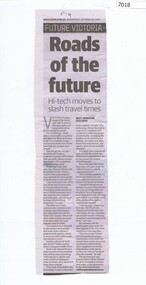
Newspaper Clipping, Roads of the future, by Matt Johnston, 23/10/2019
Article on new high-tech underground GPS application to be used in the North East Link to manage traffic.Black and White newspaper clippingnorth east link -
 Greensborough Historical Society
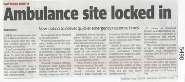
Newspaper Clipping, Diamond Valley Leader, Ambulance site locked in, 07/11/2018
A new site has been secured for a Watsonia North ambulance branch after the original location proposed was deemed unsuitable.News article 1 page, black text.watsonia north, ambulance station, grimshaw street watsonia -
Glenelg Shire Council Cultural Collection
Book, The Bible, n.d
Pearson Family Bible. Tan leather bound King James bible, embossed on front & Back covers. Spine also embossed and ridged horizontally. Gold lettering on spine. Gold edges to pages. Two brown satin bookmarks contains family register between Old and New Testamentsreligious text, religion, bible, family bible, pearson family, king james -
 Greensborough Historical Society
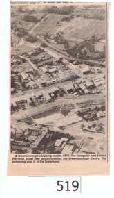
Newspaper clipping, Greensborough shopping centre 1970, 1970_
The photograph is of the centre of Greensborough in 1970, prior to the Greensborough Plaza being built. The Partington farm house, named 'Alwyn' (after Alan and Wyn Partington) can be seen north of the Railway Line. Alan and Wyn had to leave this farm in 1976 - moving to a new house - built by son Gary - at 54 Manatunga Circuit - to make way for the creation of Whatmough Park and development of the Hailes Street-The Circuit-Greensborough Plaza precinct.This is an important visual record of Greensborough before the redevelopment of the late 1970's. It also shows the Whatmough park area when it was still the Partington family farm.A black and white newspaper clipping featuring an aerial photograph.Nilgreensborough streets, greensborough, aerial photograph, 1970, partington, whatmough park, greensborough swimming pool -
 Greensborough Historical Society
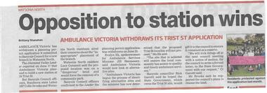
Newspaper clipping, Opposition to station wins, 01/07/2015
Ambulance Victoria has withdrawn its application to build a new branch in Trist Street Watsonia North following community concerns.News clipping, black text, colour image.trist street watsonia north, ambulance victoria -
 Greensborough Historical Society
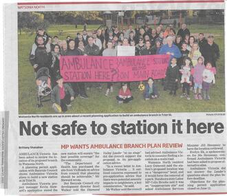
Newspaper clipping, Not safe to station it here, 17/06/2015
Ambulance Victoria's plans to build a new station at Trist Street Watsonia North are to be reviewed, following residents' objections.News clipping, black text, colour image.ambulance victoria, trist street watsonia north -
 Greensborough Historical Society
Photograph - Digital Image, Willis Vale, 1950c
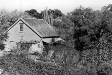
House built by Edward Maygar, Robert Whatmough lived there mid 19th century and later sold to Partington family. It was located on the Plenty River at Partington's Flat Greensborough. The derelict Willis Vale house was vandalized later destroyed in 1964 when a fire originating from North Plenty Gorge - Kurrak Road - was lit by two teenage boys and made its way several kilometres down to Partington's Flat Greensborough. This photo was taken after the Partington's moved house in 1947 across the river where Alan built their new Alwyn house that had access to electricity.A pioneer home in Greensborough.Digital copy of black and white photograph.willis vale, partington family, robert whatmough, maygar family -
 Greensborough Historical Society
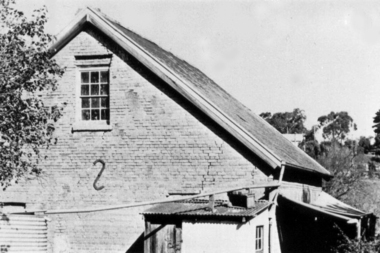
Photograph - Digital Image, Brickwork, Willis Vale, 1950c
Close up photograph of a section of brickwork at Willis Vale. This is the end wall under the roof. Willis Vale built by Edward Maygar, Robert Whatmough lived there mid 19th century and later sold to Partington family. It was located on the Plenty River at Partington's Flat Greensborough. Land use included farming and orchards. The derelict Willis Vale house was vandalized in 1964 and destroyed when a fire originating from North Plenty Gorge - Kurrak Road - was lit by two teenage boys and made its way several kilometres down to Partington's Flat Greensborough. This photo was taken after the Partington's moved house in 1947 across the river where Alan built their new Alwyn house that had access to electricity.Part of Willis Vale, a pioneer home in the Greensborough area.Digital copy of black and white photograph.willis vale -
 Greensborough Historical Society
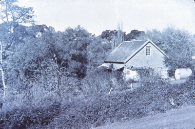
Photograph - Digital Image, Willis Vale, 1950c
Willis Vale: House built by Edward Maygar, Robert Whatmough lived there mid 19th century and later sold to Partington family. It was located on the Plenty River at Partington's Flat Greensborough. Land use included farming and orchards. The derelict Willis Vale house was vandalized in 1964 and destroyed when a fire originating from North Plenty Gorge - Kurrak Road - was lit by two teenage boys and made its way several kilometres down to Partington's Flat Greensborough. This photo was taken after the Partington's moved house in 1947 across the river where Alan built their new Alwyn house that had access to electricity.Home of the Partington familyDigital copy of black and white photograph.willis vale, partington family, whatmough, maygar family -
 Greensborough Historical Society
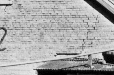
Photograph - Digital Image, Willis Vale, 1950c
Willis Vale: House built by Edward Maygar, Robert Whatmough lived there mid 19th century and later sold to Partington family. It was located on the Plenty River at Partington's Flat Greensborough. Land use included farming and orchards. The derelict Willis Vale house was vandalized in 1964 and destroyed when a fire originating from North Plenty Gorge - Kurrak Road - was lit by two teenage boys and made its way several kilometres down to Partington's Flat Greensborough. This photo was taken after the Partington's moved house in 1947; across the river where Alan built their new Alwyn house that had access to electricity.Home of the Partington familyDigital copy of black and white photograph.willis vale, partington, whatmough, maygar -
![Photograph - Digital image, Willis Vale [side view], 1950c](/media/collectors/4f729f5697f83e03086015b8/items/5502a2592162f11024c32328/item-media/5502a2852162f11024c3268d/item-fit-380x285.jpg) Greensborough Historical Society
Greensborough Historical SocietyPhotograph - Digital image, Willis Vale [side view], 1950c
Willis Vale: House built by Edward Maygar, Robert Whatmough lived there mid 19th century and later sold to Partington family. It was located on the Plenty River at Partington's Flat Greensborough. Land use included farming and orchards. The derelict Willis Vale house was vandalized in 1964 and destroyed when a fire originating from North Plenty Gorge - Kurrak Road - was lit by two teenage boys and made its way several kilometres down to Partington's Flat Greensborough. This photo was taken after the Partington's moved house in 1947. across the river where Alan built their new Alwyn house that had access to electricity. Home of the Partington family Home of the Partington familyDigital copy of black and white photograph.willis vale, partington, whatmough, maygar -
 City of Moorabbin Historical Society (Operating the Box Cottage Museum)
Document - Genealogy Chart Henry Dendy (Photocopy), 19 thC
In 1840 Henry Dendy, a farmer in Surrey, England acquired a "Special Survey" from the Commissioners for Land and Emigration which gave Dendy the right to choose land in Port Phillip for the "bargain basement" price of only £1 per acre for 5120 acres, (an area of 8 square miles). The Special Survey also included the right to "the shipment of a worker for every £20 spent on land, whose free passage was paid by the Crown, equalling a total of 100 workers ". Accordingly Dendy sold his English holdings and paid the required £5120 and arrived in Melbourne in February 1841. However by this time land in the new colony was selling for £5 - £40 per acre. Because Henry Dendy possessed the order from the Colonial Office in London he was able to successfully oppose Super-intendant LaTrobe's attempts to alter the price of the land. Dendy appointed Jonathan Were, (an entrepreneur, who had arrived in 1839), as his Manager and who later became a partner. Together, Dendy and Were decided on an area 5 miles south from Melbourne, bounded by North Road, East Boundary Road, South Road and to the west by Port Phillip Bay. Were and Dendy pitched their tents in the area now known as ' Park St, Brighton' and sank a well near the corner of 'St Andrew's St and Wells St'. By 1845 J.B Were and Company had bought almost half of Dendy's land and Were built himself "Moorabbin House" in Were St Brighton made from stone, quarried from local cliffs. It was still standing in 1924. Legend records Moorabbin is named after the Aboriginal word for ' Mother's Milk ' The soil is very fertile and well supplied with water especially in the area called 'East Brighton' - now known as Bentleigh and East Bentleigh - By 1850 the area had developed with numerous market gardens, dairy farms, fruit gardens and vineyards supplying food for the growing population of Melbourne.In 1840 Henry Dendy, a farmer in Surrey, England acquired a "Special Survey" from the Commissioners for Land and Emigration which gave Dendy the right to choose land in Port Phillip for the price of only £1 per acre for 5120 acres. This land was called Brighton in the Parish of Moorabbin, County of Bourke and emigrants developed the land establishing market gardens , dairy and poultry farms that provided the food for the growing population of Melbourne. A photocopy of the Genealogy Chart of the Dendy Family that Henry Dendy brought with him when he emigrated to Melbourne 1841Genealogy signs and descriptionsdendy henry, dendy's special survey brighton 1841, governor gipps, captain lonsdale, super-intendant latrobe, port phillip, melbourne, new south wales, squatters, emmigrants, county of bourke, parish of moorabbin, early settlers, pioneers, market gardeners, dairy farmers, fruit farms, moorabbin, bentleigh, brighton, cheltenham, were jonathan binn, -
City of Moorabbin Historical Society (Operating the Box Cottage Museum)
Document, Henry Dendy family Shield
In 1840 Henry Dendy, a farmer in Surrey, England acquired a "Special Survey" from the Commissioners for Land and Emigration which gave Dendy the right to choose land in Port Phillip for the "bargain basement" price of only £1 per acre for 5120 acres, (an area of 8 square miles). The Special Survey also included the right to "the shipment of a worker for every £20 spent on land, whose free passage was paid by the Crown, equalling a total of 100 workers ". Accordingly Dendy sold his English holdings and paid the required £5120 and arrived in Melbourne in February 1841. However by this time land in the new colony was selling for £5 - £40 per acre. Because Henry Dendy possessed the order from the Colonial Office in London he was able to successfully oppose Super-intendant LaTrobe's attempts to alter the price of the land. Dendy appointed Jonathan Were, (an entrepreneur, who had arrived in 1839), as his Manager and who later became a partner. Together, Dendy and Were decided on an area 5 miles south from Melbourne, bounded by North Road, East Boundary Road, South Road and to the west by Port Phillip Bay. Were and Dendy pitched their tents in the area now known as ' Park St, Brighton' and sank a well near the corner of 'St Andrew's St and Wells St'. By 1845 J.B Were and Company had bought almost half of Dendy's land and Were built himself "Moorabbin House" in Were St Brighton made from stone, quarried from local cliffs. It was still standing in 1924. Legend records Moorabbin is named after the Aboriginal word for ' Mother's Milk ' The soil is very fertile and well supplied with water especially in the area called 'East Brighton' - now known as Bentleigh and East Bentleigh - By 1850 the area had developed with numerous market gardens, dairy farms, fruit gardens and vineyards supplying food for the growing population of Melbourne. dendy henry, dendy's special survey brighton 1841, governor gipps, captain lonsdale, super-intendant latrobe, port phillip, melbourne, new south wales, squatters, emmigrants, county of bourke, parish of moorabbin, early settlers, pioneers, market gardeners, dairy farmers, fruit farms, moorabbin, bentleigh, brighton, cheltenham, were jonathan binn, -
 City of Moorabbin Historical Society (Operating the Box Cottage Museum)
Document - Pedigree of Henry Dendy, c1840 Original ; Copy 1985
This is a copy of the document brought by Henry Dendy to the Colony in 1841. In 1840 Henry Dendy, a farmer in Surrey, England acquired a "Special Survey" from the Commissioners for Land and Emigration which gave Dendy the right to choose land in Port Phillip for the "bargain basement" price of only £1 per acre for 5120 acres, (an area of 8 square miles). The Special Survey also included the right to "the shipment of a worker for every £20 spent on land, whose free passage was paid by the Crown, equalling a total of 100 workers ". Accordingly Dendy sold his English holdings and paid the required £5120 and arrived in Melbourne in February 1841. However by this time land in the new colony was selling for £5 - £40 per acre. Because Henry Dendy possessed the order from the Colonial Office in London he was able to successfully oppose Super-intendant LaTrobe's attempts to alter the price of the land. Dendy appointed Jonathan Were, (an entrepreneur, who had arrived in 1839), as his Manager and who later became a partner. Together, Dendy and Were decided on an area 5 miles south from Melbourne, bounded by North Road, East Boundary Road, South Road and to the west by Port Phillip Bay. Were and Dendy pitched their tents in the area now known as ' Park St, Brighton' and sank a well near the corner of 'St Andrew's St and Wells St'. By 1845 J.B Were and Company had bought almost half of Dendy's land and Were built himself "Moorabbin House" in Were St Brighton made from stone, quarried from local cliffs. It was still standing in 1924. Legend records Moorabbin is named after the Aboriginal word for ' Mother's Milk ' The soil is very fertile and well supplied with water especially in the area called 'East Brighton' - now known as Bentleigh and East Bentleigh - By 1850 the area had developed with numerous market gardens, dairy farms, fruit gardens and vineyards supplying food for the growing population of Melbourne. A copy of a paper chart of the Pedigree of Henry Dendy in a wooden frame with glassPedigree / of the branch of the family / DENDY moorabbin, brighton, henry dend special survey 1841 y, early settlers, pioneers, market gardeners -
 City of Moorabbin Historical Society (Operating the Box Cottage Museum)
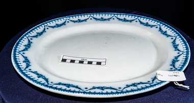
Kitchen Equipment, meat platter 'CETEM WARE', c1930
The Maling Pottery of Newcastle upon Tyne, England, was in production from 1762 to 1963. In its heyday it claimed to be the biggest pottery in the world. The first Maling pottery was established at North Hylton, near Sunderland, in 1762 by William Maling. William’s descendants who moved to the Newcastle area and built a succession of larger works. The last of these – the Ford B pottery – was begun in 1878 and occupied a 14 acre site... Maling’s stock in trade was everyday white ware – marmalade jars for Keillers and Coopers, crockery for railways, shipping lines and hotels, and a huge variety of domestic kitchenware. With a significant export trade in the 1920s they had showrooms in Australia, New Zealand and Denmark. Mary Ford, daughter of an Edinburgh glass manufacturer, married Christopher Maling. Christopher Thompson Maling’s initials form one of the company’s early factory marks – the letters CTM inscribed vertically inside a triangle. The Maling name (which had first appeared with the castle mark in the 1920s) and extended to the trade name “Cetem Ware” when the company adopted its well known trademark of a castle in the early years of this century. The “Cetem” name continued to be used into the 1930s. the Maling name continued to be used as a trademark until the factory finally closed in 1963 The outbreak of World War 11 in 1939 marked the beginning of a long decline. Many of the factory’s workers were called up for military service, and wartime restrictions prevented decorative ware being produced for the home market.A larger oval china platter with blue garland around the rim ‘ CETEM WARE’ EMPIRE c1930 On base ; CETEM WARE / over a Castle / EMPIRE / Rd No 519757 china, pottery, cetem ware, maling pottery co ltd., maling william, maling christopher thompson, ford mary, newcastle upon tyne uk, crockery, north hylton sunderland uk, moorabbin, bentleigh, market gardeners, early settlers, cheltenham, world war 11 1939-45, cooking -
 City of Moorabbin Historical Society (Operating the Box Cottage Museum)
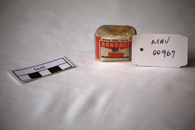
Bandage, cotton, mid 20thC
A bandage is a piece of material used either to support a medical device such as a dressing or splint, or on its own to provide support to the body; it can also be used to restrict a part of the body. G. J. Coles opened the 'Coles Variety Store' on 9 April 1914 on Smith Street in the Melbourne, Victoria suburb of Collingwood. Further expansion occurred and Coles' interest in food retailing was spurred in 1958 when it acquired 54 John Connell Dickins grocery stores. It then acquired the Beilby's chain in South Australia in 1959 and 265 Matthews Thompson grocery stores in New South Wales in 1960 .In 1960, the first supermarket was opened in the Melbourne suburb Balwyn North, at the corner of Burke and Doncaster Roads where a modernised version continues to operate. By 1973, Coles had established stores in all Australian capital cities. From 1962, its supermarkets were branded Coles New World with accompanying rocket imagery. In 1991, the stores were re-branded Coles Supermarkets and from 1998, simply as Coles. George James (G. J.) Coles learned the retail trade working for his father's 'Coles Store' business from 1910 to 1913. The store continued operating as "The Original Coles" at Wilmot, Tasmania until it was destroyed by a fire on 24 January 2014. An unused, 1 inch ( 2.5cm ) x 6 yards ( 2metres) cotton, ‘open wove’ bandage in a cellophane wrapper sold by G.J. Coles Pty Ltd Variety StoresCellophane wrapper top: WHITE OPEN WOVE / BANDAGE / 1 X 6 YDS. / SPECIAL QUALITY / G.J.COLES * pharmacy, medicines, bandages, wounds, early settlers, market gardeners, moorabbin, bentleigh, cheltenham, cotton, gauze, coles g j pty ltd., variety stores, supermarkets, smith street collingwood, retailers, shops -
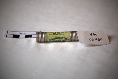 City of Moorabbin Historical Society (Operating the Box Cottage Museum)
Containers, metal cylindar 'Benzedrine ' inhaler, mid 20thC
An Inhaler helps to ease breathing and provides relief from a stuffy nose caused by colds and allergies. An empty metal cylinder with screw top containing ‘Benzedrine’ inhalation’BENZEDRINE’./ BRAND / INHALER / FOR RELIEVING NASAL CONGESTION / Each tube is packed with /……… / Remove both ends , insert tapered /end well into nostril / …….. Effectiveness gradually decreases / with use / ….Distributed by / MENLEY&JAMES (Col) LTD / NORTH SYDNEY N.S.W. / For Smith, Kline & French Laboratories pharmacy, medicines, asthma inhalers, respiratory diseases, early settlers, market gardeners, moorabbin, bentleigh, cheltenham, benzedrine, sydney, new south wales, menley & james (col) ltd., smith, kline & french pty ltd -
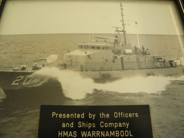 Geelong RSL Sub Branch
Photograph - HMAS Warrnambool, Early 21st century
HMAS Warrnambool (FCPB 204) was a Fremantle-class Patrol Boat. The Warrnambool was Launched in 1980 and Decommissionbed in 2005.Designs for new class of patrol boat began in the late 1960s, the HMAS Warrnambool (FCPB204) was launched on 1980 and de commissioned in 2005. The Warrnambool was built by North Queensland Engineers and Agents and carried a company of 22 personnel.A black and white photograph in a black wooden frame with a gold stripe on the inside edge of the frame. There is a presentation plaque on the glass of the frame.The presentation plaque 'Presented by the Officers abd Ships Company HMAS Warrnambool'hmas warrnambool (fcpb204), patrol boat, -
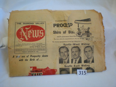 Greensborough Historical Society
Newspaper, Diamond Valley News, Diamond Valley News. 29 Sept. 1964 : Commemorative edition : Proclamation of the Shire of Diamond Valley, 29/09/1964
The Shire of Diamond Valley was formerly the north ward of the City of Heidelberg. In 1960 following inequitable rate increases, it was proposed that the 'north ward' sever itself from Heidelberg and form its own municipality. The Shire was abolished in 1994 and areas redistributed to Banyule, Nillumbik and Darebin councils.This newspaper reports on the history and politics of the new Shire of Diamond Valley. It includes news articles and advertising material from local businesses. 40 page commemorative edition. Yellowed newsprint. Front cover icludes "The Shire of Diamond Valley" on red outline map of shire and photos of the 12 inaugural councillors. 3 copies.shire of diamond valley, greensborough, diamond valley news -
 Eltham District Historical Society Inc
Photograph, Spring Excursion, Hume and Hovell bus tour Stage 2, Seymour, Benalla; 26 Oct 1997, 26/10/1997
MONUMENT HUNTING THE HUME AND HOVELL WAY (Newsletter No. 117, November 1997, by Diana Bassett-Smith) Sunday October 26 1997 dawned bright and very warm. Some twenty-five members, complete with picnic baskets, met outside the Eltham Library awaiting the Cobb and Co. large coach which would be taking us on the second leg of our travels along the route of the early explorers Hume and Hovell. Stephen West was our very good driver for the day. He would be guided around the circuitous route by Russell Yeoman wh9 had made a detailed study, not only of the intended route, but of the story of these two explorers. During the trip Russell regaled us with poetry, quotations from the Journals and the History of the Shire of Seymour, "The New Crossing Place: by Martindale, 1982, (now Mitchell Shire due to the recent amalgamations). We headed towards the Hume Highway via Greensborough and Cooper Street and proceeded north to our first stop, noting on the way Monument Hill in the distance which is near Kilmore and, according to Russell, well worth the effort to visit as the view across the valley is magnificent. Past Sunday Creek Valley, Mt Piper and Mt Disappointment, all traversed and noted and named by them. We passed through Tallarook, then onto Seymour where we took photos of the monument telling us that Hume and Hovell had passed through on the 28th of October 1824. We also deviated down Hume and Hovell Road viewing deer and emu farming and the Bellbourie property now a sanctuary. Leaving Seymour behind we travelled up the Avenel Road to the Avenel monument, pyramidal in design of four reducing square blocks with a sharply pointed peak, erected in 1924 in memory of the 1824 exploration. The day was warming up and the countryside showing the dryness of the current drought. A parallel note had been made in their journal too of 1824 of the drought appearance of the country they were traversing. At Seven Creeks, Euroa we stopped for some minutes to check the monument placed 20th November 1924 to commemorate their passage on the 29th December 1824. More photos. Russell had pointed out the abrupt termination of the distant ranges which is noted in their journal. The next monument is beside the road at the entrance to Honey Suckle Creek Caravan Park, Violet Town. The squarish shaped monument some eight feet high is topped with a simple steel cross, and was to mark the date of 28th December 1824 and built for the 20th November 1924. By now it was 12.20 and nearly lunchtime as we drove along the Warranbayne Road to Roach's Road, monument hunting without success. Though there is a large, what appears to be an old timber sign which was hard to read, maybe this was the lost monument. In many of the paddocks hay had been cut and baled or was being cut, what a contrast to the rugged country they had passed through which was smoky from the fires of the natives burning off By 1.00 pm we were at Benalla and pulled up beside the park where abundant beds of roses filled the air with their scent and the smell of barbecued food twitched the nostrils whilst the cheerful sounds of other picnickers could be heard throughout the park. We left the bus and collected up our picnics, dispersed to the various tables and enjoyed the shade from the various European trees. 2.00 pm and we were on the road again driving along the Benalla, Mansfield, Yea road. The Swanpool monument states that they passed four miles south and returned three miles north. Then we stopped at the Barjarg monument which notes that they camped near this spot. It is again a pyramidal monument and this time topped with a steel arrow indicating their route of the 29th November 1824. Half an hour later we came to another monument, again with a steel arrow marker on top and the plaque dated the 2nd of 12th 1824. Erected on the 12th of 12th 1924. "They blazed the way that we might inherit the land." Another square based and needle topped monument appeared at Yarck near Yea and this plaque records the date of 3 December 1824. Near McGuigans Road Russell related that the expedition had lost a dog but it had found them next day, the dog was apparently torn by a kangaroo. A short while later Russell reminded us here of the problems they encountered in crossing the Goulburn River near Molesworth where banks were high, water deep and wide. "Good coat of grass but quite dry due to drought". At Yea we stopped for afternoon tea and raided the last of our picnics and looked at the monument to their journey of 1824, situated at a corner of the gardens near the bowling green. No photo – we were out of film. We returned home via Kinglake West and Whittlesea past the Yan Yean Reservoir, not full. 5.00 pm back at Eltham we emptied out of the bus and everyone, including Joan Cole, collected their things, Joan also had the major souvenir of the day, a large carp she had picked up from the river bank, her cat was in for a great feast. The day was made so interesting by the informed commentary which Russell provided. His background knowledge of the route and nature of the journey could only have come from many hours of reading and driving the area. Thank you to Russell and to everyone who made the day so informative and pleasurable. Diana Bassett-Smith. Record of the Society's history of activities - Spring 1997 excursionRoll of 35mm colour negative film, 6 stripsFuji 200shire of eltham historical society, activities, pretty hill, seymour, benalla, hume and hovell, monuments -
 Eltham District Historical Society Inc
Photograph, Spring Excursion, Hume and Hovell bus tour Stage 2, Seymour, Benalla; 26 Oct 1997, 26/10/1997
MONUMENT HUNTING THE HUME AND HOVELL WAY (Newsletter No. 117, November 1997, by Diana Bassett-Smith) Sunday October 26 1997 dawned bright and very warm. Some twenty-five members, complete with picnic baskets, met outside the Eltham Library awaiting the Cobb and Co. large coach which would be taking us on the second leg of our travels along the route of the early explorers Hume and Hovell. Stephen West was our very good driver for the day. He would be guided around the circuitous route by Russell Yeoman wh9 had made a detailed study, not only of the intended route, but of the story of these two explorers. During the trip Russell regaled us with poetry, quotations from the Journals and the History of the Shire of Seymour, "The New Crossing Place: by Martindale, 1982, (now Mitchell Shire due to the recent amalgamations). We headed towards the Hume Highway via Greensborough and Cooper Street and proceeded north to our first stop, noting on the way Monument Hill in the distance which is near Kilmore and, according to Russell, well worth the effort to visit as the view across the valley is magnificent. Past Sunday Creek Valley, Mt Piper and Mt Disappointment, all traversed and noted and named by them. We passed through Tallarook, then onto Seymour where we took photos of the monument telling us that Hume and Hovell had passed through on the 28th of October 1824. We also deviated down Hume and Hovell Road viewing deer and emu farming and the Bellbourie property now a sanctuary. Leaving Seymour behind we travelled up the Avenel Road to the Avenel monument, pyramidal in design of four reducing square blocks with a sharply pointed peak, erected in 1924 in memory of the 1824 exploration. The day was warming up and the countryside showing the dryness of the current drought. A parallel note had been made in their journal too of 1824 of the drought appearance of the country they were traversing. At Seven Creeks, Euroa we stopped for some minutes to check the monument placed 20th November 1924 to commemorate their passage on the 29th December 1824. More photos. Russell had pointed out the abrupt termination of the distant ranges which is noted in their journal. The next monument is beside the road at the entrance to Honey Suckle Creek Caravan Park, Violet Town. The squarish shaped monument some eight feet high is topped with a simple steel cross, and was to mark the date of 28th December 1824 and built for the 20th November 1924. By now it was 12.20 and nearly lunchtime as we drove along the Warranbayne Road to Roach's Road, monument hunting without success. Though there is a large, what appears to be an old timber sign which was hard to read, maybe this was the lost monument. In many of the paddocks hay had been cut and baled or was being cut, what a contrast to the rugged country they had passed through which was smoky from the fires of the natives burning off By 1.00 pm we were at Benalla and pulled up beside the park where abundant beds of roses filled the air with their scent and the smell of barbecued food twitched the nostrils whilst the cheerful sounds of other picnickers could be heard throughout the park. We left the bus and collected up our picnics, dispersed to the various tables and enjoyed the shade from the various European trees. 2.00 pm and we were on the road again driving along the Benalla, Mansfield, Yea road. The Swanpool monument states that they passed four miles south and returned three miles north. Then we stopped at the Barjarg monument which notes that they camped near this spot. It is again a pyramidal monument and this time topped with a steel arrow indicating their route of the 29th November 1824. Half an hour later we came to another monument, again with a steel arrow marker on top and the plaque dated the 2nd of 12th 1824. Erected on the 12th of 12th 1924. "They blazed the way that we might inherit the land." Another square based and needle topped monument appeared at Yarck near Yea and this plaque records the date of 3 December 1824. Near McGuigans Road Russell related that the expedition had lost a dog but it had found them next day, the dog was apparently torn by a kangaroo. A short while later Russell reminded us here of the problems they encountered in crossing the Goulburn River near Molesworth where banks were high, water deep and wide. "Good coat of grass but quite dry due to drought". At Yea we stopped for afternoon tea and raided the last of our picnics and looked at the monument to their journey of 1824, situated at a corner of the gardens near the bowling green. No photo – we were out of film. We returned home via Kinglake West and Whittlesea past the Yan Yean Reservoir, not full. 5.00 pm back at Eltham we emptied out of the bus and everyone, including Joan Cole, collected their things, Joan also had the major souvenir of the day, a large carp she had picked up from the river bank, her cat was in for a great feast. The day was made so interesting by the informed commentary which Russell provided. His background knowledge of the route and nature of the journey could only have come from many hours of reading and driving the area. Thank you to Russell and to everyone who made the day so informative and pleasurable. Diana Bassett-Smith. Record of the Society's history of activities - Spring 1997 excursionRoll of 35mm colour negative film, 6 stripsFuji 200shire of eltham historical society, activities, pretty hill, seymour, benalla, hume and hovell, monuments