Showing 945 items matching "reservoir"
-
 Ballarat Tramway Museum
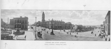
Photograph - Illustration, "Lydiard and Sturt Streets", c1900
Illustration titled "Lydiard and Sturt Streets" - Centre of Ballarat, showing Post Office. In the bottom left-hand corner is a single-deck horse tram with a Havelock Tobacco advert on the roof. The illustration gives a sweeping wide angle view of the intersection with the Post Office marked with the words "Post Office". There are several horse-drawn vehicles and pedestrians in the view. The image has the initials "HJS" and "PS&Co" on both photos in the bottom corners. On the rear is a photo of the Gong Gong Reservoir with a note about its size and construction - built 1877.Yields information about a single deck horse tram and the intersection of Sturt and Lydiard StreetsIllustration cut from a magazine or publicationballarat, illustrations, sturt st, lydiard st, post office, horse trams, single deck horse tram, gong gong reservoir -
 Kew Historical Society Inc
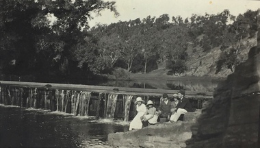
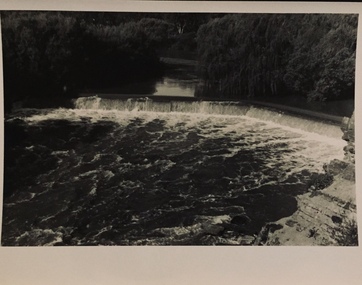
Photograph, Richardson Family at Dight's Falls, 1920
Dight’s Falls in Studley Park is an artificial weir built on a natural rock bar across the Yarra. The weir was built in the 1840s to provide water to the ‘Ceres’ flour-mill, one of the first in Victoria. The falls were later to become known as Dight’s Falls after the owners of the mill. Later, a pumping station was built on the Kew side of the river, which pumped water uphill to a reservoir in Walmer Street that provided water to the Melbourne Botanical Gardens and to Albert Park Lake. The area around Dight’s Falls was and is frequently used for recreational activities.This photograph forms part of the collection assembled by the historian Dorothy Rogers, that was donated to the Kew Historical Society by her son John Rogers in 2015. The manuscripts, photographs, maps, and documents were sourced by her from both family and local collections or produced as references for her print publications. Many were directly used by Rogers in writing ‘Lovely Old Homes of Kew’ (1961) and 'A History of Kew' (1973), or the numerous articles on local history that she produced for suburban newspapers. Most of the photographs in the collection include detailed annotations in her hand. The Rogers Collection provides a comprehensive insight into the working habits of a historian in the 1960s and 1970s. Together it forms the largest privately-donated collection within the archives of the Kew Historical Society.Black and white photograph of the Richardson family seated on the Kew side of Dight's Falls in 1920. One of the girls in the photograph was to become the Melbourne historian Dorothy (Richardson) Rogers.Annotation on reverse: "Mrs D. Rogers, 29 Park Crst Kew. Dights Falls 1920"dight's falls - kew (vic) - fairfield (vic), sport and recreation - kew (vic), dorothy rogers -
 Kew Historical Society Inc
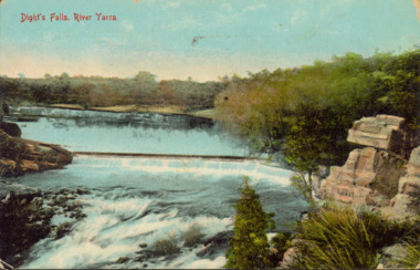
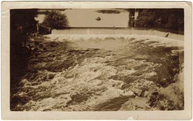
Postcard - Dight's Falls, River Yarra, c.1911
Dight’s Falls in Studley Park is an artificial weir built on a natural rock bar across the Yarra. The weir was built in the 1840s to provide water to the ‘Ceres’ flour-mill, one of the first in Victoria. The falls were later to become known as Dight’s Falls after the owners of the mill. Later, a pumping station was built on the Kew side of the river, which pumped water uphill to a reservoir in Walmer Street that provided water to the Melbourne Botanical Gardens and to Albert Park Lake. The area around Dight’s Falls was and is frequently used for recreational activities.Dated postcard allowing one to analyse the form of the Falls in 1911Colour postcard, of Dight's Falls on the River Yarra between Kew and Fairfield. The photograph is taken looking upstream towards the Falls from the Kew side, from the embankment in the vicinity of the Pumping Station. Obverse: "Dight's falls, Kew" Reverse: "Printed in Great Britain Writing in ink on Reverse: "31/3/1911 / To dear Nell with best wishes for a happy birthday from your old friend Eve / [Addressed to] "Mrs N Dunn, Prahran" Franked Victorian 1d stamp on Reverse top rightdight's falls, dight's falls - kew (vic) - fairfield (vic) -
 Kew Historical Society Inc
Photograph - Yarra in Flood from Willsmere, North Kew, 1923
Flooding of the Yarra Valley, including that section of the Yarra bordering Kew and Kew East in the north and west of the municipality, was a regular occurrence. Extreme flood events of the Yarra River are recorded to have occurred in 1891, 1901, 1916, 1923 and 1934. The Municipality of Kew's response to these floods was to enact planning decisions restricting residential development in flood prone areas following the floods of 1916, 1921 and 1934. While floods continued after the development of the Upper Yarra Reservoir (construction 1948-57), the regularity and extent of these inundations diminished. Original, large sepia photograph showing men, women and children who have gathered on a grassy verge, probably farm land, to look out across the flooded Yarra Valley at Willsmere, North Kew. In the medium distance are three houses that are largely submerged by the flood waters as well as a number of Eucalypts. Judging by the clothes of the spectators, the date might be 1901 or 1916, but probably the latter due to the hats worn by a number of the women. Inscribed reverse: "Gift of Kerrie Woollard (KCC) (P)C.1923yarra river valley, kew east (vic.), floods, willsmere -
 Kew Historical Society Inc
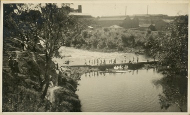
Photograph - Crossing Dights' Falls on the Yarra by foot
Dight’s Falls in Studley Park is an artificial weir built on a natural rock bar across the Yarra. The weir was built in the 1840s to provide water to the ‘Ceres’ flour-mill, one of the first in Victoria. The falls were later to become known as Dight’s Falls after the owners of the mill. Later, a pumping station was built on the Kew side of the river, which pumped water uphill to a reservoir in Walmer Street that provided water to the Melbourne Botanical Gardens and to Albert Park Lake. The area around Dight’s Falls was and is frequently used for recreational activities.Rare original print photograph of people walking across Dight's Falls when the river flow was low. View west towards Abbotsford. Photograph taken from Kew side of river above the Falls.Reverse: "M Holmes"dight's falls, river yarra -- kew - abbotsford -
 Kew Historical Society Inc
Photograph - Flood at Fairfield Park, 1934
Flooding of the Yarra Valley, including that section of the Yarra bordering Kew and Kew East in the north and west of the municipality, was a regular occurrence. Extreme flood events of the Yarra River are recorded to have occurred in 1891, 1901, 1916, 1923 and 1934. The Municipality of Kew's response to these floods was to enact planning decisions restricting residential development in flood prone areas following the floods of 1916, 1921 and 1934. While floods continued after the development of the Upper Yarra Reservoir (construction 1948-57), the regularity and extent of these inundations diminished.Black and white print positive. Yarra River at Fairfield in 1934. Major flood resulting in submerged buildings in middle ground and onlookers on far bankReverse: "Flood of Yarra at Fairfield Park 1934"fairfield park, yarra valley, river yarra, floods -- 1934 -
 Kew Historical Society Inc
Photograph - Yarra in Flood, 1934
Flooding of the Yarra Valley, including that section of the Yarra bordering Kew and Kew East in the north and west of the municipality, was a regular occurrence. Extreme flood events of the Yarra River are recorded to have occurred in 1891, 1901, 1916, 1923 and 1934. The Municipality of Kew's response to these floods was to enact planning decisions restricting residential development in flood prone areas following the floods of 1916, 1921 and 1934. While floods continued after the development of the Upper Yarra Reservoir (construction 1948-57), the regularity and extent of these inundations diminished.Black and white print positive. 1934 floods of the Yarra Valley. Location Fairfield looking towards wooded hillside. Houses floating in river.Reverse: "From Fairfield Park (11936?) back towards hill (Wurundjeri Spur?)"floods -- 1934, yarra valley, yarra river, fairfield park -
 Kew Historical Society Inc
Photograph - River Yarra in Flood from Kilby Road
Flooding of the Yarra Valley, including that section of the Yarra bordering Kew and Kew East in the north and west of the municipality, was a regular occurrence. Extreme flood events of the Yarra River are recorded to have occurred in 1891, 1901, 1916, 1923 and 1934. The Municipality of Kew's response to these floods was to enact planning decisions restricting residential development in flood prone areas following the floods of 1916, 1921 and 1934. While floods continued after the development of the Upper Yarra Reservoir (construction 1948-57), the regularity and extent of these inundations diminished.Print copy of an original photo of the River Yarra in Flood, taken from Kilby Road.VIEW ACROSS YARRA IN FLOOD / FROM KILBY RD KEWkilby road, floods -- kew (vic.), kilby farm -
 Kew Historical Society Inc
Collection, Floods in North Kew (Series), 1929–1934
Flooding of the Yarra Valley, including that section of the Yarra bordering Kew and Kew East in the north and west of the municipality, was a regular occurrence. Extreme flood events of the Yarra River are recorded to have occurred in 1891, 1901, 1916, 1923 and 1934. The Municipality of Kew's response to these floods was to enact planning decisions restricting residential development in flood prone areas following the floods of 1916, 1921 and 1934. While floods continued after the development of the Upper Yarra Reservoir (construction 1948-57), the regularity and extent of these inundations diminished. Natural disasters had an impact on the development and settlement of Melbourne and its suburbs. Flooding in the Melbourne region was a regular event in the nineteenth and for most of the twentieth centuries. Changes in the impact of natural disasters could occur due to a number of factors. This collection of small snapshots, mostly taken from Kellett Grove in North Kew, provide provenanced evidence of flooding in the area before the development of the unnatural flood barrier that is the Eastern Freeway.Collection of 16 monochrome photographs, annotated on verso by different hands, of the flooding of the River Yarra in North Kew in the third and fourth decades of the twentieth century [1920s & 1930s]. Individual photos include the dates of different floods. Many of the photos were taken from the rear of 8 Kellett Grove; a house still extant in 2023yarra river -- north kew, floods -- yarra valley, floods -- north kew, floods -- 1929, floods -- 1934, natural disasters -- kew -
 Kew Historical Society Inc
Photograph - Dight's Falls, 1920s
Dight’s Falls in Studley Park is an artificial weir built on a natural rock bar across the Yarra. The weir was built in the 1840s to provide water to the ‘Ceres’ flour-mill, one of the first in Victoria. The falls were later to become known as Dight’s Falls after the owners of the mill. Later, a pumping station was built on the Kew side of the river, which pumped water uphill to a reservoir in Walmer Street that provided water to the Melbourne Botanical Gardens and to Albert Park Lake. The area around Dight’s Falls was and is frequently used for recreational activities.One of a series of photographs, probably taken by Henry Christian of the Yarra River in Kew. An item from an outstanding and diverse photographic collection, assembled by members of the Christian and Washfold families of Kew.River Yarra at Dight’s Falls, Kew/Fairfield photographed from Kew bank.dight's falls, river yarra, christian-washfold collection -
 Kew Historical Society Inc
Photograph - The Race at Dight's Falls, 1925
Dight’s Falls in Studley Park is an artificial weir built on a natural rock bar across the Yarra. The weir was built in the 1840s to provide water to the ‘Ceres’ flour-mill, one of the first in Victoria. The falls were later to become known as Dight’s Falls after the owners of the mill. Later, a pumping station was built on the Kew side of the river, which pumped water uphill to a reservoir in Walmer Street that provided water to the Melbourne Botanical Gardens and to Albert Park Lake. The area around Dight’s Falls was and is frequently used for recreational activities.Original, black and white positive of water flowing over the 'Race' at Dight's Falls in MelbourneInscribed verso: "The Race at Dight's Falls / River Yarra Melbourne / 1.3.25" "Kodak Print"dight's falls, river yarra, yarra -- kew (vic.) -
 Glen Eira City Council History and Heritage Collection
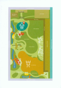
Event Run-sheet and Map, "Booran Reserve Official Opening"
This run-sheet and map were used for the opening of Booran Reserve at the corner of Booran and Glenhuntly Roads on Tuesday 11 April 2017. The Reserve was officially opened by the Mayor, Cr. Mary Delahunty and The Hon. Philip Dalidakis, MP, Minister for Innovation. The run-sheet contains information about the Order of Proceedings of the opening ceremony. The map notes the locations of reserved parking, the route taken by Mayor Mary Delahunty and Minister Philip Dalidakis through the Reserve, and the speech and smoking ceremony site. The site of the Reserve was previously the Caulfield Service Reservoir.Black and white printed run-sheet, and green, teal, red, yellow, blue and khaki colour printed map -
 Geoffrey Kaye Museum of Anaesthetic History
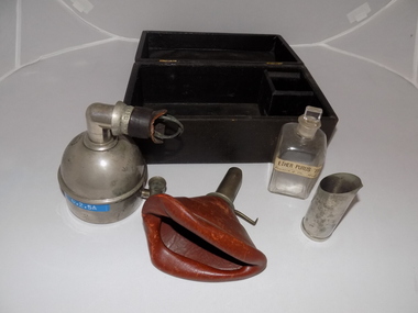
Equipment - Inhaler, Clover, Mayer & Meltzer, 1877
Dr. Joseph Clover (1825-1882), an English physician, first described his Portable Regulating Ether Inhaler on Jan. 20, 1877. Clover was an especially sought after anesthesiologist and early pioneer in the specialty. This was the best-known of many inhalers that Clover designed. The dome-shaped reservoir was turned to points on a control dial to gradually increase or decrease the percentage of the air that passed over the ether. Several inventors based new inhalers on this, while the original continued to be manufactured as late as the beginning of WWII. (Source: Wood Library Museum)Black round topped box with brass hooks at front and brass hinges at rear. There is a black fabric handle on the top. Inside the box is black padding with the manufacturer's logo printed in gold leaf. There is a square section in the base of the box for holding the square clear glass bottle for ether. There is also a dome-shaped metal inhaler with a "whistle tip" type connection to the mask. The mask is made of tan leather. There is also a metal ether measure for pouring the ether.Printed in gold leaf inside lid of box: MAYER & MELTZER [?] PORTLAND ST. / MAKERS •Engraved on side of inhaler: Mayer & Meltzer / London •Stamped on connector of inhaler: MAYER & MELTZER RN NO 212327 •Engraved on rear of inhaler: Clover's Inhaler •Printed in white on blue sticker: O.2.5A •Measurements have been stamped on the bottom of the inhaler. •Printed in black ink on mask: MADE IN ENGLAND •Stamped on metal connector inside mask: 6 •Printed in black ink on white manufacturer's label on glass bottle: ETHER PURUS '720 / H. Francis & Co., Melbourne.clover, joseph, mollison, crawford henry, george bankin, mccaul, kevin, royal women's hospital, coroner, freemason, surgeon, gynaecologist, obstetrician, mayer & meltzer, francis & co, melbourne, ether purus -
 Falls Creek Historical Society
Functional object - Peacock Hand Warmers
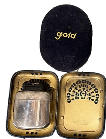
These mid-1960s Peacock and Gold brand lighter fuel hand warmers were used in Falls Creek to keep out the cold. The concept behind the hand warmer is that through combustion (ignition) of lighter fluid (light petrol distillate) it becomes a catalytic heater, relying on a catalysed chemical reaction to break down molecules and create heat. The devices could get quite hot, not hot enough to set paper on fire, but hot enough to give a nasty burn if sustained contact against your skin occurred. The construction of the device is very simple. There is very fine rolled wire mesh which fits on top of the reservoir body. After you fill the reservoir with lighter fluid, vapor pressure builds up. The device ignites by heating the grill with a match or lighter until it glows red. There is no open flame. The hand warmer also had a velvet bag to place it in after igniting to prevent direct skin contact. They were able to generate heat for up to a whole day. The Japanese company Yamato Shokai Ltd was founded in 1923 in the city of Osaka. Destroyed during air raids in 1945, the factory was rebuilt in 1946. They manufactured the Peacock brand pocket-warmer and sold it internationally.These items are significant because they were commonly used at Falls Creek.The pocket warmer is a small, relatively flat device with a tank at the bottom and a burner mechanism a t the top. "PEACOCK/MADE IN JAPAN" is engraved near the burner. The warmer fits into a metal case which features a series of ventilation holes in the shape of a peacock's tail. JAPANESE PAT. 237413.483177 MADE IN JAPANhand warmers, ski equipment 1960s -
 Bendigo Historical Society Inc.
Book - SCHOOL EXERCISE BOOK, 23/08/1929
School Exercise Book minus covers. Entries hand written in ink on various topics 1. Nature diary 23 Aug 1929 - 23 Nov; 2. Essays on St George, St Patrick St Andrew; 3. Nature history with flower pressings; 4. the Guide Laws; 5. Health Rules. Teachers name written on some pages s M Hoffmeyer. Note (R Upson, catalog note 2009: ''Would guess that the student was female. Reference made to Crusoe Reservoir on first page is the only link to Bendigo'').bendigo, education, m hoffmeyer. crusoe reservoir -
 Bendigo Historical Society Inc.
Photograph - The Young and Wirth Families at Preston Vale, near the Springs Sedgwick, 1880s-1900s
The Phil Wilkin Collection contains a series of 11 Items. The related items can be found by clicking on the reference link below. The following history of the Young family and their descendants who lived at the Springs is provided by Phil Wilkin. His Great Grandparents were Frances Young and August Wirth. Phil has also provided notes on the Wilkin Family and some history of the gold mining in Sedgwick. Frances Young's parents Joseph and Margaret Young owned the property called "The Old Place, Preston Vale or Wellington Flat" at Sedgwick near the Springs. Joseph Young owned and Managed the Standard Brewery which was located at Campbells Creek during the late 1800’s early 1900’s. Joseph and Margaret are buried in the Harcourt cemetery. In 1880 August Wirth lived at Mosquito Creek (Lake Eppalock, Victoria) when he married Frances Young. In 1902 they moved to part of Joseph Young's property. They milked cows and sold cattle for a living. One of their children Charles Wirth (Phil Wilkin's Grandfather) bought the land in 1935 after his parents had died. Charles Wirth was a councillor and also was president of the Shire of Strathfieldsaye. The "Old Place" was part of the property owned by members of the family. The old house at the Springs was burnt out by bushfire in January 1944 and much of the stonework was later vandalized by campers. The original Coliban Water Works were designed in 1863 by the Irish engineer Joseph Brady. The system included 70 kilometres of open water channels, aqueducts, syphons and tunnels to carry water (by gravity) from the Coliban River at Malmsbury, north to Castlemaine and Bendigo. Sedgwick is a locality in Central Victoria, Australia. It is located in the City of Greater Bendigo. Facilities include a public hall that opened in 1958 and CFA Rural fire station. It was named Upper Emu Creek until 1901 when it was renamed as Sedgwick after British geologist Adam Sedgwick.Thirty Four Photos of Joseph Young's property near "The Springs" on the main Coliban water channel from Malmsbury to the Sandhurst Reservoir in Bendigo. This item contains family history of Joeph's descendant Charles Wirth, who was a councillor for the Shire of Strathfieldsaye. The water race descends through a concrete chute, and continues sharply around the contour of the hills. Once it descended into a syphon across the gully. The are 182 photos in this series and can be found at 8683.1 to 8683.11. The series also includes photos of the surrounding farming land and the remains of an old house. There are also some notes on the pioneers of the district.history, bendigo, coliban water, joseph brady, irrigation, the springs, sedgwick, charles wirth, preston vale, joseph and margaret young, standard brewery campbells creek harcourt, phil wilkin collection -
 Bendigo Historical Society Inc.
Slide - DIGGERS & MINING. GETTING THE GOLD, c1850s
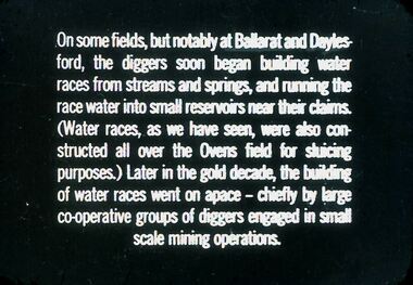
Diggers & Mining. Getting the Gold. Slide: On some fields, but notably at Ballarat and Daylesford, the diggers soon began building water races from streams and springs, and running the race water into small reservoirs near their claims. (Water races, as we have seen, were also constructed all over the Ovens field for sluicing purposes.) Later in the gold decade, the building of water races went on space - chiefly by large co-operative groups of diggers engaged in small scale mining operations. Markings: 69 994.LIF:4. Used as a teaching aid.hanimounteducation, tertiary, goldfields -
 Ballarat Tramway Museum
Photograph - Colour Photograph/s - set of 2, Carolyn Dean, 3/04/2004 12:00:00 AM
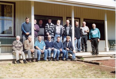
Set of two colour prints of the BTM Planning day at The Lodge, Moorabool Reservoir Saturday, 3/4/2004. Both photos by Carolyn Dean. 2710.1 - shows the participants in front of The Lodge. Left to right; top row; Len Millar, Alan Snowball, Greg Rodgers, Simon Jenkins, Roger Salen, Gary Wood, Paul Mong, Richard Gilbert and Frank Puls. Sitting on step; Austin Brehaut, Peter Winspur, Stephen Butler, Warren Doubleday, Alastair Reither, Sam Boon. 2710.2 - photo of the restored Lodge, Friends of the Moorabool Lodge group.On rear of each photo in ink, the incorrect date "02.04.04".btm, moorabool -
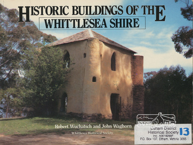 Eltham District Historical Society Inc
Book, Robert Wuchatsch 1950- et al, Historic buildings of the Whittlesea Shire / Robert Wuchatsch and John Waghorn, 1985
Historical accounts of 55 buildings which portray the Shire of Whittlesea's diverse history. Contains 70 photographs, all full page, 12 in colour. Each is accompanied by a comprehensive account of the homes' origins and changing ownerships through the generations. There are also drawings and a map of the Shire of Whittlesea. Reference to the Peter Lalor Home Building Co-Operative Society Ltd., a project devised to overcome the critical shortage after World War 2. Produced as part of the celebrations for Victoria's 150th anniversary by the Whittlesea Historical Society. A photograph of Bear's Castle at Yan Yean Reservoir is on the cover.Paperback; [114] p. : ill. (some col.), 1 map ; 19 x 25 cm.ISBN 0958866309buildings, shire of whittlesesa, bear's castle -
 Eltham District Historical Society Inc
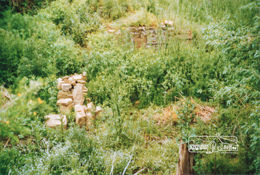
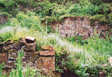
Photograph, Ruins of Coulstocks Mill, Janefield, South Morang
Mill Park Farm at Janefield on the Plenty River was established around 1840 by George Coulstock where he grew wheat. His flour mill was one of the first in Victoria, under construction as early as 1841. After bushfires and Coulstock's early death in 1842, the farm and its mill were taken over by local landowners Henry Miller and John Brock. Peter Hurlestone took charge of the mill. With water diverted from the Plenty River to fill the newly built Yan Yean Reservoir which opened in 1857, the Hurlestone family quit and that was the demise of the mill.Four colour photographs showing the ruins of Coulstocks Flour Mill (Janefield Mill), Janefield. 1. Stone wall 2. Old mill 3. Stone remains of old mill 4. Tree near old mill sitemills, flour mills, coulstock, janefield, plenty river, ruins, stone walls, plenty gorge, bundoora -
 Eltham District Historical Society Inc
Photograph, Ruins of Coulstocks Mill, Janefield, South Morang
Mill Park Farm at Janefield on the Plenty River was established around 1840 by George Coulstock where he grew wheat. His flour mill was one of the first in Victoria, under construction as early as 1841. After bushfires and Coulstock's early death in 1842, the farm and its mill were taken over by local landowners Henry Miller and John Brock. Peter Hurlestone took charge of the mill. With water diverted from the Plenty River to fill the newly built Yan Yean Reservoir which opened in 1857, the Hurlestone family quit and that was the demise of the mill.Five colour photographs of ruins of Coulstocks Mill, Janefield (Mill Park - Bundoora)mills, flour mills, coulstock, janefield, plenty river, ruins, stone walls, bundoora, plenty gorge -
 Eltham District Historical Society Inc
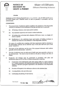
Document, Notice of Decision to Grant a Permit; Ref: E94/306 - Subdivision of 30-34 Diosma Road; 16 November 1994, 16/11/1994
This permit was eventually overturned following community objection and the land was donated by Yarra Valley Water for use as a community reserve.The Stokes Orchard Estate collection is typical of housing developments of the late 1970s and 1980s. It was one of the earliest estates in Eltham following the nearby Woodridge Estate development.A4 document consisting of ten pagesAs notedstokes place, eltham, stokes orchard, stokes orchard estate, streets, houses, peter and carla vermey, diosma road, letter of objection, melbourne metropolitan board of works, planning application, reservoir, shire of eltham -
 Bendigo Historical Society Inc.
Document - JOSEPH BRADY COLLECTION: NEWSPAPER CUTTINGS
Photocopied newspaper cutting from Bendigo Advertiser 22nd Dec 1952, pertaining to donation of Joseph Brady bound notebooks. Brady was engineer of the Bendigo Waterworks in 1858 and accepted appointment as engineer to the contractors of the construction of a segment of the Melbourne Sandhurst railway. One book was related to the Bendigo Waterworks containing particulars of Crusoe Reservoir. The other surrounding Cornish & Bruce contracts for the middle section of the Mt Alexander Railway. Books donated to Bendigo by Mrs A Strickland of Currie King Island, Brady's granddaughter. Town Clerk accepted books and said Museum was closed but Historical Society would welcome donation.bendigo, waterworks, coliban water -
 Kiewa Valley Historical Society
7 small black and white photographs of Pretty Valley, c1948
In 1947 it was proposed to construct a dam on the Pretty Valley branch of the East Kiewa River. This was part of the initial planning in 1937. The Pretty Valley Reservoir was to be part of a pumped-storage scheme with a pumping station located immediately below the main structure. Preparatory work was commenced in 1946 with erection of staff accommodation. Between 1947 and 1950 the main camp was erected, access roads, constructed and banks and benches at the dam site undertaken. Following the financial crisis in 1951, a review of the scheme was carried out and work ceased in June 1951. Construction of the dam was deleted from the programme of works and all buildings removed.A pictorial history of part of the initial planning in 1937 for a dam to be constructed at Pretty Valley as part of the Kiewa Hydro Electric Scheme.7 small black and white photographs of Pretty ValleyAll photos have a circular stamp on the back with 'Print by Willson White Albury' enclosed. Photo 1 - on the back, handwritten in ink 'New 22Kv pump line - Pretty Valley Nov. 1948'. In pencil '18'. Photo 2 - On the back, handwritten in ink 'Pretty Valley - Staff mess on right Nov. 1948'. In pencil '18'. Photo 3 - On the back, handwritten in ink 'Pretty Valley Basin - looking S.E. Nov. 1948'. In pencil '5'. Photo 4 - On the back, handwritten in ink 'New pump 22Kv line, Pretty Valley - looking towards Mt. Mackie. Nov. 1948'. In pencil '5'. Photo 5 - On the back, handwritten in ink 'Pretty Valley. Mt. Cope just out of picture extreme right. Nov. 1948'. In pencil '78'. Photo 6 - on the back, handwritten in ink 'View from Pretty Valley Ruined Castle in Background Nov. 1948'. In pencil '78'. Photo 7 - on the back, handwritten in ink 'Pretty Valley Pump line (Nov. 1948)'. In pencil'78'.construct, dam, pretty valley -
 Eltham District Historical Society Inc
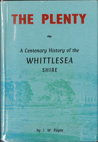
Book, J. W. Payne, The Plenty: A Centenary History of the Whittlesea Shire, 1975
This book traces the one hundered years of the development of the Shire of Whittlesea, from the discovery by Hume and Hovell in 1824 to the time of the centenary in 1975. The intervening years saw the settlement of Vandemonians, Sydney-siders, English, Scots, Irish and Germans, Black Thursday, the building of the Yan Yean Reservoir, the Plenty River flour millls, the timber industry, fruit-growing and export and vineyards. Personalities and pubs, subdivisions, stories of the Findon Hunt Club and various Shires including Epping. History of education and transiton from rural to urban in the south of the Shire. The work is illustrated with maps and photographs. The Shire is now the City of Whittlesea and is an immediate neighbour to the north of the Shire of Nillumbik. shire of whittlesea -
 Federation University Historical Collection
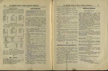
Magazine of 24 pages, Baxter & Stubbs, Print, Ballarat School of Mines, Student Magazine, Third Term, 1911, 1911
Table of Contents: Editorial, Inventions and inventors, The hydroplane launch "Maple Leaf III", Hints on examination, First aid, Some geographical features at Ballarat, The volumetric determination of potassium, Milk, The cannon, A scientific apologue, New inventions by Tesla, Coronation fair, First aid, Cinematography, Electrical chatter, Education and training of engineers, Mining notes, Engineering students midwinter excursion, Hints to S.M. B. yachtsmen, News and notes, The long and short of it, Abbreviated account of the geology of the Forbes-Parkes gold field, Excursion to Pyke's Creek Reservoir, A practical joke, Sports, Past students, Answers to correspondents, Editorial notes.table of contents: editorial, inventions and inventors, the hydroplane launch "maple leaf iii", hints on examination, first aid, some geographical features at ballarat, the volumetric determination of potassium, milk, the cannon, a scientific apologue, new inventions by tesla, coronation fair, first aid, cinematography, electrical chatter, education and training of engineers, mining notes, engineering students midwinter excursion, hints to s.m. b. yachtsmen, news and notes, the long and short of it, abbreviated account of the geology of the forbes-parkes gold field, excursion to pyke's creek reservoir, a practical joke, sports, past students, answers to correspondents, editorial notes., alumni: w. k. clifford, j. adam, wilfred avery, h. baxter, l. w. g. buchner, h. caulfield, a. cropper, e. b. crossley, w. currie, dave don, hilary dowling, chas fraser, a. d. galloway, w. geldard,t. e. copeland, l, j. coulter, j. dickinson, g. h. hall, godfrey s.hart, w. b. hirt, h. e. hawkesworth, oliver e. jager, carl janssen, w. t. lakeland, l. j. lambert, c. lund, r. i. moore, byron k. moore, f. a. moss, jack orr, douglas runting, w. t. sayer, l. seward, h. s. sheppard, c. e. sands, n. stuckey, r. vale, r. watts, reg williamson, w. baragwanath, c. c. corrie, r. g. walker, g. g. sams, r. a. j. roberts, r. blight, h. cornell, v. booth, miss l johnson. -
 Vision Australia
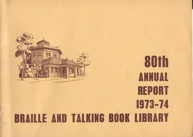
Administrative record - Text, 80th annual report 1973-74 Braille and Talking Book Library, 1974
Annual report of the Braille & Talking Book Library including Minutes of the AGM, Board of Director's Report, President's report and financial statements. Items also included are: Miss Alice McClelland was invited to read the Honour Roll in recognition on her 51 years and 7 months of service with the library, appointment of Joan Simmonds as Chief Librarian, retirement of Ivan Molloy, Mrs Hearn, Peter Sumner and Heather Bedson, the first Braille Book of the Year presented to Keith Dunstan as decided by the literary panel of Barrett Reid, Stephen Murray Smith and Lloyd O'Neill, the revival of the Annual Fair, and the work of the Sixty-Niners, Benalla, Reservoir and Altona auxiliaries.1 volume with text and illustrationsbraille and talking book library, annual reports -
 Geoffrey Kaye Museum of Anaesthetic History
Equipment - Inhaler, Clover (modified)
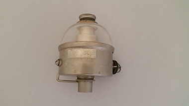
Dr. Joseph Clover (1825-1882), an English physician, first described his Portable Regulating Ether Inhaler on Jan. 20, 1877. Clover was an especially sought after anesthesiologist and early pioneer in the specialty. This was the best-known of many inhalers that Clover designed. The dome-shaped reservoir was turned to points on a control dial to gradually increase or decrease the percentage of the air that passed over the ether. Several inventors based new inhalers on this, while the original continued to be manufactured as late as the beginning of WWII. This modified version differs from the original Clover inhaler as it has a glass dome chamber at the top allowing the level of ether to be monitored.Metal based chamber with glass dome top. There is a metal connection point at the top of the glass dome for a rebreather bag, with a whistle tip connection point at the base of the chamber for a facemask. There is no rebreather bag or facemask. There is a black plastic stopper to the side of the chamber, with a glass bulb with a metal wire cage covering.joseph clover, lambert buck, closed administration -
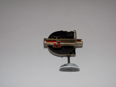 Geoffrey Kaye Museum of Anaesthetic History
Equipment - Inhaler, Clover (sectioned)
Dr. Joseph Clover (1825-1882), an English physician, first described his Portable Regulating Ether Inhaler on Jan. 20, 1877. Clover was an especially sought after anesthesiologist and early pioneer in the specialty. This was the best-known of many inhalers that Clover designed. The dome-shaped reservoir was turned to points on a control dial to gradually increase or decrease the percentage of the air that passed over the ether. Several inventors based new inhalers on this, while the original continued to be manufactured as late as the beginning of WWII. Dr Geoffrey Kaye sectioned equipment, enabling medical students to see the inner workings and gain insight into the engineering of the equipment.Cross section of Clover's inhaler attached to a circular metal base.Handwritten on white sticker at rear: P / 26 / B •White print on blue sticker: O.2.3. •Engraved on dome side of inhaler: G. Kaye sect. 1939.joseph clover, geoffrey kaye -
 National Vietnam Veterans Museum (NVVM)
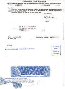
Document - National Service Selection for Service Card, NS 69(Rev 1/68) with envelope, 1960s
Perforated pro-forma call-up card from Department of Labour and National Service : National Service Registration Office addressed to Mr N E Swainston, 37 Leamington St, Reservoir Vic, dated 01/10/70 with Registration Number 21765955. Specific details are typed in black ink, and the document is signed by registrar W K Allen. Back of card advises recipient that he will be given at least 7 days' notice of the time and place for the medical, and that it is his responsibility to notify changes in marital status or address. Envelope is marked O.H.M.S, National Service Registration Papers and torn open at bottomnational service - australia, conscription, call-up, swainston collection