Showing 576 items matching "route map"
-
 Melbourne Tram Museum
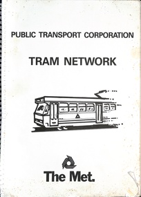
Book, Public Transport Corporation (PTC), "Tram Network", late 1980s
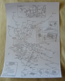
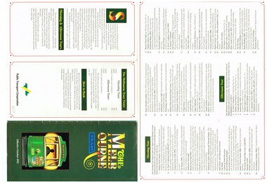
... with a The Met logo. Provides information in map form on each tram route ...Titled "Metropolitan Tram Network" published by Public Transport Corporation with a drawing of an A class tram on the cover along with a The Met logo. Provides information in map form on each tram route in a large print format, contact numbers and some general information as a disability service. Gives details of Met customers services, office hours and Legend. See also item 1181 and 6000 for other examples. Possibly late 1980s as the Port Melbourne and St Kilda Light rail lines are detailed.Demonstrates the provision of information about Melbourne's tram routes at the time.Book - wire bound, 34 pages + card covers.tramways, ptc, the met, maps, disability services, tram routes, routes -
 Melbourne Tram Museum
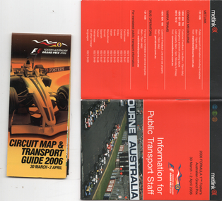
Booklet, Metlink, "Information for public transport staff - 2006 Formula 1 Australian Grand Prix", 2006
Gives details of event for train, tram and bus crews, event program and transport map, including shunting details, announcements, bus replacement services, electric or automatic points, route alterations. On the back cover has contact telephone numbers and web addresses - Published by Metlink. Fold out map gives a detail map of the course, locations for transport and details of the event - published by the Grand Prix corporation. Yields information the 2006 Grand Prix event at Albert Park.Set of 2 items - both within a clear plastic envelope. 1 - booklet 40 pages with foldout map centre stapled 2 - 16 fold map - circuit map and transport guide tramways, grand prix, metlink, formula 1, albert park -
 Melbourne Tram Museum
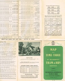
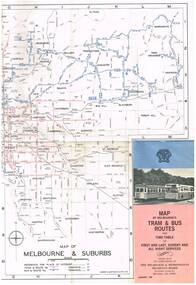
Map, Melbourne & Metropolitan Tramways Board (MMTB), "Map and timetable of Melbourne Tram and Bus Services" - May 1956", May. 1956
Fold out map (10 sections), coloured of Melbourne's Tram and Bus routes, route numbers, rail lines, municipalities boundaries and location of major places of interest. Titled - "Map and timetable of Melbourne Tram and Bus Services" - May 1956". At base of map - timetable of all night trams and bus services. On rear index to routes, 1st and last services, time of Sunday am services, LaTrobe St. services and photo of Wattle Park. Dated May 1956. Note the inset map shows Bourke St as a bus. Three copies held. 413.1 - as for above but with a pasted over section titled "Time table of all - night bus services" on the base of the map replacing the all night tram and bus services. Dated 3/7/1957. Copy from donation of Gary Butler added 3/12/15. See Reg Item 2300 for the March 1952 version.trams, tramways, melbourne, map, tram & bus services, all night services, mmtb -
 Melbourne Tram Museum
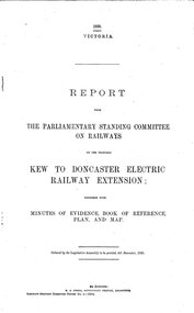
Document - Report, Victorian Parliament, "Report - The Parliamentary Standing Committee on the Proposed Kew to Doncaster Electric Railway Extension", Dec. 1930
... of evidence, book of reference, plan and map, dated 4/12/1930... of evidence, book of reference, plan and map, dated 4/12/1930 ...Printed - 12 page foolscap, stapled on left hand side, 2 sections, Victorian State Parliamentary Report titled "Report - The Parliamentary Standing Committee on Railways on the Proposed Kew to Doncaster Electric Railway Extension", together with minutes of evidence, book of reference, plan and map, dated 4/12/1930. References a 1928 document, looks at construction costs, sites for railway stations, estimated revenue and expenditure, existing Kew line financials, town planning, bus services, MMTB input, tram services, alternatives, committee views, recommendations and a map of proposed routes, showing roads and tram services. Includes references to the Kodak estate and APM proposals at Fairfield. See Reg Item 2102.3 for the 1928 report.trams, tramways, doncaster, railways, public transport, kew -
 Melbourne Tram Museum
Pamphlet, The Met, "North East Travel Come Aboard - Bundoora - RMIT Route 86", Oct. 1995
Folded full colour printed on glossy paper pamphlet titled "North East Travel Come Aboard - Bundoora - RMIT Route 86" for the opening of the Bundoora tramway extension 12 October 1995, with a complimentary ticket. Gives details of the extension to the RMIT Campus at Bundoora, associated bus routes and the companies operating them, RMIT launch celebrations, and a map. Published by The Met, has logos. Two copies held.trams, tramways, bundoora, route 86, opening, rmit -
 Melbourne Tram Museum
Map, Melbourne & Metropolitan Tramways Board (MMTB), "Map of Melbourne's Tram and Bus Routes" - January 1967, Jan. 1967
... services Route Numbers MMTB Fold out map (12 sections), coloured ...Fold out map (12 sections), coloured of Melbourne's Tram and Bus routes, route numbers, rail lines, and location of major places of interest. On rear index to routes, 1st and last services, time of Sunday am services, list of suburbs, how to get there, MMTB Offices and depots and timetable list of all-night buses services.. Dated January 1967. Two copies held. 3rd copy added 28/5/15trams, tramways, melbourne, map, tram & bus services, all night services, route numbers, mmtb -
 Melbourne Tram Museum
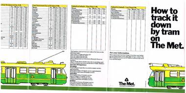
Pamphlet, The Met, "How to track it down by tram on The Met", mid 1980's
Fold out pamphlet, 7 folds, titled "How to track it down by tram on The Met", early 1980's, with a map of the tram system, The Met logos, providing information about tram services to specific locations. Also provides details of first and last trams for all tram routes and service frequency. Second copy added 17-4-2017trams, tramways, melbourne, map, tram services, the met -
 Melbourne Tram Museum
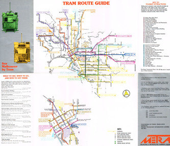
Pamphlet, Melbourne & Metropolitan Tramways Board (MMTB), "See Melbourne by Tram", early 1980's
Fold out pamphlet - 10 sections, titled ""See Melbourne by Tram" providing a detailed tram map of Melbourne, key tourist locations marked on map. Notes that Travelcard Zone 1 can be purchased for all locations. Published by the MMTB early 1980's. Trading name used on pamphlet is "METRA". On inside has sketches and advertisements for some tourist locations and restaurants. Notes which routes were replaced by buses on Sundays. Second copy added 13/1/2017 from Donation of John Prideaux.trams, tramways, map, mmtb, metra -
 Melbourne Tram Museum
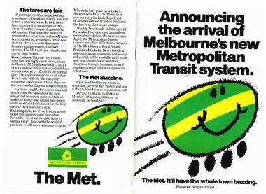
Pamphlet, The Met, "Announcing the arrival of Melbourne's new Metropolitan Transit system", late 1983
Set of 9 pamphlets about the Neighbourhood ticket system - basically the same with changes for each neighbourhood. .1 - Eight page, A4, colour printed on gloss paper, centre stapled, titled "Announcing the arrival of Melbourne's new Metropolitan Transit system - Ringwood Neighbourhood" Explains the revised ticketing system, known as Neighbourhoods, notes the formation of The Met, uses a cartoon characterisation of vehicles, explains how the system works, boundaries, various options, travel cards, concessions and introductory offers. Pamphlet focused on the Ringwood Zone, has a detailed map of the public transport routes within the zone. 2nd copy added 14-5-2016 from the estate of Charles Craig. .2 - Inner .3 - St Albans .4 - Dandenong .5 - Box Hill - (two copies held) .6 - Frankston .7 - Moorabbin .8 - Greensborough .9 - Werribee - added 26/10/2016.trams, tramways, map, the met, tickets, fares, ringwood -
 Melbourne Tram Museum
Poster, P. Sohns, "Melbourne Tram Track map (June 2006)", 2006
Poster - titled "Melbourne Tram Track map (June 2006)", line drawing on white paper, showing a detailed track map of junctions, depots, cross overs, route numbers, Preston Workshop, track out of service but overhead still in place, routes under construction of planning. Prepared by P. Sohns with Research by H. Waldron. Dated 8/4/2006. Has a detailed inserted of the city area. One unlaminated and one laminated copy held.trams, tramways, melbourne, map, tramways, depots, workshops, tram routes -
 Melbourne Tram Museum
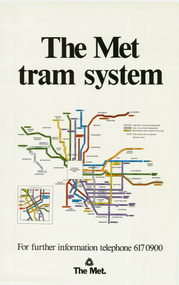
Poster, The Met, "The Met Tram System", mid 1990's
... Trams tramways Melbourne Tramways Tram Routes Map Posters Poster ...Poster - full colour on semi gloss paper titled "The Met Tram System" showing in a diagrammatic form the Melbourne tram routes, major street names, route numbers, principal suburbs, terminal names, central area (pre Docklands, post light rail to St Kilda and Port Melbourne) and ticket zones. Has The Met logo and the Public Transport Corporation names on the bottom. Mid 1990's, Batman Ave still shown. 2nd copy added 2-2-2019 and scanned, replaced image file.trams, tramways, melbourne, tramways, tram routes, map, posters -
 Melbourne Tram Museum
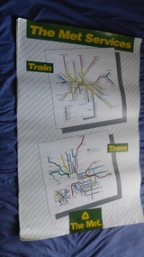
Poster, The Met, "The Met Services", mid 1990's
... Trams tramways Melbourne Tramways Tram Routes Railways Map ...Poster - full colour on semi gloss paper titled "The Met Services" showing in a diagrammatic form the Melbourne tram and rail routes. For the tram section, (similar to Reg Item 509), shows major street names, route numbers, principal suburbs, terminal names, central area (pre Docklands, post light rail to St Kilda and Port Melbourne) and ticket zones. The rail map section shows the Neighbourhood ticket zones, the rail line via Altona (the direct route is not shown) and shows the St Kilda and Port Melbourne light rail lines. Has The Met logo and the Public Transport Corporation names on the bottom. Mid 1990's, Batman Ave still shown. See also Reg Items 696 and 696 for maps of the time.trams, tramways, melbourne, tramways, tram routes, railways, map, posters, tickets, neighbourhood tickets -
 Melbourne Tram Museum
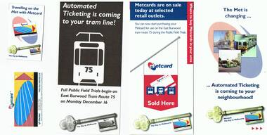
Pamphlet, The Met, "The Met is changing - automated ticketing", Dec. 1996
Set of pamphlets associated with the Metcard rollout and one Metcard ticket issued on 16/12/1996 on route 75. The envelope from the donor notes first Metcard (auto ticketing) and Associated brochures. .1 - Five folded to DL size - full colour pamphlet - "The Met is changing - automated ticketing is coming to your neighbourhood! - explains how the system works, purchasing of tickets and their use.] (Second copy added 3/12/2016) .2 - four fold to DL size - full colour pamphlet - "Metcards are on sale today at selected retail outlets" - providing on information on the purchase of Metcards and a map with associated addresses of outlets along route 75. .3 - single DL size sheet - black and white - explaining full field trials on route 75 and the use of Metcards. .4 - small pocket size 6 fold full colour sheet explaining how the Metcards could be purchased on the trams and validated. .5 - Metcard No. 00383158 - with the Metcard logo, The Met logo, validated at 1242pm on 16/12/1996. .6 - five fold DL - as for .2, for tram routes 3,64, 67, 78 and 79. .7 - five fold DL - similar to .1, more general document. .8 - 3 fold DL - "Everything you need to know about automated ticketing in three words" - What, When and How - explains Metcard. Could be a very early pamphlet.trams, tramways, tickets, metcard, ptc, the met, neighbourhood tickets, route 75, route 3, route 64, route 67, route 68, route 79 -
 Melbourne Tram Museum
Document - Research Notes, Don Storey, "Melbourne electric Tramways - Gunzel Notes - a timeline of the Melbourne Electric Tramways", 2003
Research Report titled - "Melbourne electric Tramways - Gunzel Notes - a timeline of the Melbourne Electric Tramways", 94 A4 unbound pages, secured by a fold back clip. Gives a summary of the periods between 1884 and 1904, 1904 to 1920, 1920 to 1983, 1983 to 1997. Has appendences for route numbers, tram allocation, depot lists, trams sold to Ballarat, Bendigo or Geelong and Preserved track. Index note an appendix for track maps but not within document. Has been scanned into two pdf (unsearchable files) pages 1-49 and 50-96 - see image files. See also Reg Item 715 for a similar document published by the ARE in 1997. See http://www.classicaustraliantv.com/Gunzel.htm - accessed 1-11-2016 Prepared by Don Storey See also Reg item 2922 for another version of the depot allocation lists.trams, tramways, melbourne, history, mmtb, the met, ptc, cable trams, history, depot allocation, preserved trams, route numbers -
 Melbourne Tram Museum
Pamphlet, Public Transport Corporation (PTC), "Free City Circle Tram", mid 1990's
... of the route, with places of interest shown. Map shows the service via... of the route, with places of interest shown. Map shows the service via ...Pamphlet - eight fold to DL size, full colour, titled "Free City Circle Tram" with a photo of a City Circle tram passing Flinders St station. Has information about Melbourne trams, the Melbourne Town Hall, Visitor Information, Walking Trails, a map of the route, with places of interest shown. Map shows the service via Spencer St. Has photos of 2013 and 909 as well. Has the City of Melbourne, Department of Infrastructure and Public Transport Corporation logos. Possible produced during the mid 1990's given the various logos used. .1 - As above, but with Yarra Trams and State Government logos See Reg Items 1387 and 2703 for other versions.trams, tramways, city circle, melbourne, public transport corporation, ptc -
 Melbourne Tram Museum
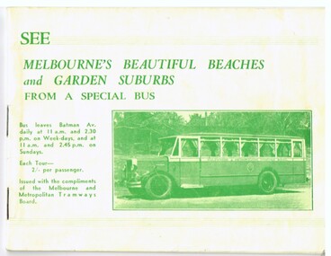
Book, Melbourne & Metropolitan Tramways Board (MMTB), "See Melbourne's Beautiful Beaches and Garden Suburbs from a Special Bus", 1938
... fares, time of departures and reservations. Each tour has a map..., time of departures and reservations. Each tour has a map ...Thirty two page landscape booklet on semi gloss white paper with off white or cream cover and single supplementary white sheet tipped onto the inside of the front cover titled "See Melbourne's Beautiful Beaches and Garden Suburbs from a Special Bus". Saddle stapled, printed letterpress. Text printed in black and green ink. Cover green ink only. The book advertising MMTB's Special tourist bus, giving overall tour details on page 1, including fares, time of departures and reservations. Each tour has a map showing the route, details of the tour route with notes and photographs. Page 14 shows a maximum traction tram on the reserved track in Dandenong road and page 30, W2 488 outbound in Victoria Parade. Page 32 has an advertisement for the Round Trip by Tram 1/-. Front cover has details of the departure times and fares and a photo of the Tourist Bus. The supplementary sheet has been prepared for the tours that operated daily from Sun Sept. 18 to Friday May 31, except Anzac Day. Ballarat Tramway Museum has a similar item, 1939-1940 version - different bus on cover. - Reg Item 1838.trams, tramways, mmtb, bus tours, melbourne, sightseeing -
 Melbourne Tram Museum
Map, Melbourne & Metropolitan Tramways Board (MMTB), MMTB Route Maps, 1979
... Series of colour maps for various tram and bus routes, dated 1979 ...Series of colour maps for various tram and bus routes, dated 1979. Also contained, not scanned are letters, reports, and specifications for printing these maps for use in shelters etc. Some have the Transport Information Centre telephone printed on them. Some are finished with a plastic laminate finish on either one or both sides. Show the major cross streets, parks, schools, other tram routes, major stop numbers, and railway lines. See also item 3909 for another example of these. Trams 1 - City route guide - R9/77 - showing all route numbers and destinations that passed through the CBD. 2 - Bourke St tram routes - R4/77 - East Brunswick Blyth St and East Preston Tyler St and intermediate routes, routes 95, 96, 97, 90, 89 and 88. 3 - Malvern, East Malvern, Carnegie, and East Brighton Tram Routes (from St Kilda Junction) - R1/79 - shows routes 5, 3, 67, 66, 61, 62, and 64. 4 - Elizabeth St tram routes - R12/77 - Essendon Airport, West Maribyrnong, North Coburg lines, routes 50, 58, 60, 54, 57, 52. 49, 59, 18, 20 and 19 5 - Flinders St tram routes - R5/78 - North Balwyn, East Burwood, routes 48, 40, 41, Hartwell, 28, 74 and 75 6 - Kew - St Kilda Beach - R1/79 - Route 69. 7 - Mont - Albert City - R11/77, shows routes 43. 47. 45. 44 8 - St Kilda Rd Tram Routes R12/77 - details South Melbourne Beach, route 1 and route 2 and St Kilda Beach routes 15, 16, and 55 otherwise shows where the various routes branch off St Kilda Road 9 - Batman Ave tram routes - R9/77 - Wattle Park, North Richmond and Prahran - routes 70, 71, 78 and 79. 10 - Footscray - Moonee Ponds - R3/81 - Route 82 11 - Swanston St tram guide - R1/79 - lists all routes and route numbers that branch or cross Swanston St between Grattan St and St Kilda Junction. 12 - Toorak Camberwell and Glen Iris tram route with Camberwell Junction and Malvern Town Hall, R1/79, routes 8, 7, 6, 72, and 73 shown. 13 - West Preston - Beach tram routes - R12/77 - routes 10, 11, 9 and 12, 14 - William St tram routes - R12/77 - Route 55, 56, and 63 - South Melbourne Depot and Domain. Buses 1 - Footscray, Sunshine, Deer Park, Nth Altona & Fishermans Bend - R2/79 2 - Box Hill bus routes to Templestowe, Heidelberg & East Kew - R6/78 - notes superseded by R3/82 3 - Plan of Russell St Melbourne bus departure bays. 4 - Box Hill, Mitcham & Ringwood bus routes to East Doncaster & Warrandyte - R3/82 5 - City - Warrandyte & East Doncaster bus routes - R3/82 & R6/78 6 - Bulleen - City - Port Melbourne - Garden City Bus route - R6/78 7 - North Altona - City bus route - 11/78 8 - Clifton Hill - Elsternwick - R2/79 9 - La Trobe - Northland - West Heidelberg - City Bus Service via East Freeway - 11/79 and R3/81 10 - Box Hill, Mitcham & Ringwood Bus Routes to East Doncaster & Warrandyte - R10/84 - with the Metropolitan Transit logo.Yields information about tram and bus routes in late 1970s early 1980s.Book - brown comb binding, card and clear plastic covers containing both bound and unbound maps and documents.K C Painter on front cover in ink.tramways, mmtb, tram routes, maps, bus routes, route numbers, routes, route guide -
 Melbourne Tram Museum
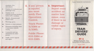
Pamphlet, Public Transport Corporation (PTC), "Tram Drivers' Guide RT 5", Aug. 1990
... colours titled "Tram Drivers' Guide RT 5", providing g a map... "Tram Drivers' Guide RT 5", providing g a map for the Route 5 ...Pamphlet for tramcars, sheet of paper folded into pocket size, 12 folds, printed on gloss paper with black and red colours titled "Tram Drivers' Guide RT 5", providing g a map for the Route 5 Malvern Bourke Road from Burke Road to St Kilda Road, showing notes for both directions, compulsory stops, facilities and features. On the reverse side, has notes regarding classes of tram, information about accidents and telephone numbers. Dated August 1990. 2nd copy added 11-12-17 from Donation of Ron Scholten.trams, tramways, ptc, malvern burke rd, accidents, tram drivers, map -
 Melbourne Tram Museum
Poster, Yarra Trams, "Melbourne Tram Network", Jan. 2014
Full colour poster printed on a vinyl plasticized based sheet, titled "Melbourne Tram Network" - showing a diagrammatic layout of Melbourne tram routes, Myki ticket notes and where tickets can be obtained, information numbers (PTV, phone applications) and information on Tram Tracker, twitter and other contact systems. Map replaced when changes made to routes 112 (split into 11 and 12 - St Kilda to Victoria Gardens) from 27/7/2014. Map dated Jan. 2014. See Reg Item 725 for a vertical format version.trams, tramways, yarra trams, ptv, maps, tramtracker, myki -
 Melbourne Tram Museum
Pamphlet, Public Transport Corporation (PTC), "The Melbourne Tram", 1992
... that was to be effective Oct. 1992. On the inside has a map showing the proposed.... On the inside has a map showing the proposed routes, a morning ...Pamphlet - full colour - folded A3 - "The Melbourne Tram", giving details of the proposed tourist tram service that was to be effective Oct. 1992. On the inside has a map showing the proposed routes, a morning and afternoon tour, fares and how to book. Has a image of Y 469 on the front cover. Randal advised that Y469 was painted dark green very briefly in 1992 - an initiated of the Kirner Government to operate "The Melbourne Tram" as a tourist service. See also the front cover of the PTC "Changing Times", Vol 2, No. 22, 18 June 1992 - htd539i4 See Reg Item 539 for a mounted decal for this service and 669 for a complimentary ticket. See Reg Item 3657 for an item in the PTC Staff newsletter for the launch of the tram and a phot. See Reg item 5962 for a calendar image of the tram.trams, tramways, the met, logos, tourist trams, y class -
 Melbourne Tram Museum
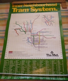
Poster, The Met, "Inner Neighbourhood tram system", mid 1980's
Poster, full colour printed on gloss paper titled "Inner Neighbourhood tram system", giving a diagrammatic Map of the tram system, suburbs, tram route destination names and route numbers and peak service route numbers. Has a separate section for the City area. Shows the routes that ran into the Greensborough and Box Hill Neighbourhoods. At the base of the map has The Met logo and name, a customer service number which has been glued over the printed number. At the base of the poster is a location guide for places of interest, sporting facilities, parks and gardens, railway stations etc.trams, tramways, the met, map, tickets, neighbourhood tickets, tramways -
 Melbourne Tram Museum
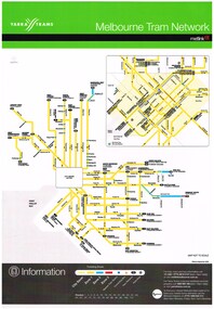
Poster, Yarra Trams, "Melbourne Tram Network", Sep. 2006
Full colour poster, A3 size, printed on laminated sheet - titled "Melbourne Tram Network. Shows a diagrammatic layout of the Melbourne tram system, shows zones (3 zones), CBD, tram terminuses, train station, park and ride locations. Has the Yarra Trams and Metlink logos. Provides contact information including a website. Notes where Metcards are available. Two copies held. Vertical format of Reg Item 719. Dated Effective September 2006. 720.2 - dated Jan. 2005 - shows the Vermont South extension under construction - see image i2. Item added 11-8-2016. 720.3 - undated - prior to Vermont South opened in 2005 - has route 112 and docklands tram line - c2004. Does not have a Yarra Trams logo.trams, tramways, yarra trams, metlink, maps, metcard, vermont south -
 Melbourne Tram Museum
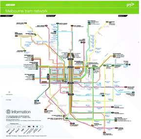
Poster, Yarra Trams, "Melbourne Tram Network", January 2014
Full colour poster printed on a vinyl plasticized based sheet titled "Melbourne Tram Network. Shows a diagrammatic layout of the Melbourne tram system, shows zones, CBD, tram terminuses, train stations, low floor tram priority routes and hospitals. Has the Yarra Trams logos. Provides contact information (PTV) including a website. Dated Effective - January 2014. See also Reg item 718 for the April 2011 version.trams, tramways, yarra trams, metlink, maps, ptv -
 Melbourne Tram Museum
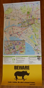
Poster, Yarra Trams, CBD and inner city tram routes, January 2012
Full colour poster printed on a vinyl plasticized based sheet showing all the public transport routes to the north and south of the CBD, includes major landmarks. Has information on where to buy tickets, customer information and tram tracker. At the base has a Beware Rhino's image. Has the Melway image as well. Dated Effective - January 2012.trams, tramways, yarra trams, maps, ptv, melbourne, public transport, rhinos -
 Melbourne Tram Museum
Poster, Yarra Trams, "Melbourne Tram Network", Jan. 2014
Full colour poster printed on a vinyl plasticized based sheet, titled "Melbourne Tram Network" - showing a diagrammatic layout of Melbourne tram routes, Myki ticket notes and where tickets can be obtained, information numbers (PTV, phone applications) and information on Tram Tracker, twitter and other contact systems. Vertical format. Map replaced when changes made to routes 112 (split into 11 and 12 - St Kilda to Victoria Gardens) from 27/7/2014. Map dated Jan. 2014. See Reg Item 625 for a horizontal format version and 726 for an earlier version. Two copies held.trams, tramways, yarra trams, ptv, maps, tramtracker, myki -
 Melbourne Tram Museum
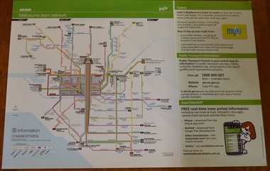
Poster, Yarra Trams, "Melbourne Tram Network", Dec. 2012
Full colour poster printed on a vinyl plasticized based sheet, titled "Melbourne Tram Network" - showing a diagrammatic layout of Melbourne tram routes, Myki ticket notes and where tickets can be obtained, information numbers (PTV, phone applications) and information on Tram Tracker, twitter and other contact systems. Map shown as effective April 2011, and printed December. 2012. Has the document information on the right hand side of the poster. See Reg Item 625 for a later version.trams, tramways, yarra trams, ptv, maps, tramtracker, myki -
 Melbourne Tram Museum
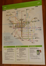
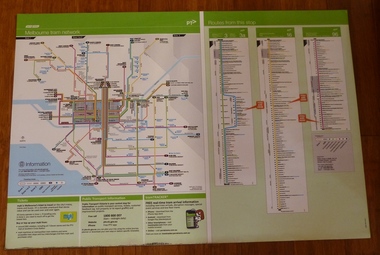
Poster, Yarra Trams, "Melbourne Tram Network" and "Routes from this stop", Apr. 2011
Full colour poster printed on a vinyl plasticized based sheet, titled "Melbourne Tram Network" - showing a diagrammatic layout of Melbourne tram routes, Myki ticket notes and where tickets can be obtained, information numbers (PTV, phone applications) and information on Tram Tracker, twitter and other contact systems on the left side and on the right side titled "Routes from this stop" showing all the routes that ran in Swanston St to Melbourne University and the major stops in the City and St Kilda Road. Map shown as effective April 2011. Has the document information on the right hand side of the poster.trams, tramways, yarra trams, ptv, maps, tramtracker, myki, swanston st, st kilda rd -
 Melbourne Tram Museum
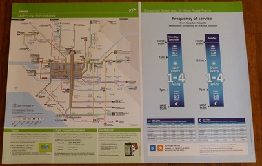
Poster, Yarra Trams, "Melbourne Tram Network" and "Swanston St and St Kilda Road Trams", Apr. 2011
Full colour poster printed on a vinyl plasticized based sheet, titled "Melbourne Tram Network" - showing a diagrammatic layout of Melbourne tram routes, Myki ticket notes and where tickets can be obtained, information numbers (PTV, phone applications) and information on Tram Tracker, twitter and other contact systems on the left side and on the right side titled "Swanston St and St Kilda Road Trams" showing the frequency of service from Stop 1 to Stop 30 - Melbourne University to St Kilda Junction. Has a table showing the first and last trams to each of the routes for Monday to Thursday, Friday, Saturday and Sunday. On the base has notes regarding accessible services. Map shown as effective April 2011. Has the document information on the right hand side of the poster.trams, tramways, yarra trams, ptv, maps, tramtracker, myki, swanston st, st kilda rd -
 Melbourne Tram Museum
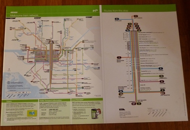
Poster, Yarra Trams, "Melbourne Tram Network" and "Routes from this Stop", Dec. 2012
Full colour poster printed on a vinyl plasticized based sheet, titled "Melbourne Tram Network" - showing a diagrammatic layout of Melbourne tram routes, Myki ticket notes and where tickets can be obtained, information numbers (PTV, phone applications) and information on Tram Tracker, twitter and other contact systems on the left side. On the right side titled "Routes from this Stop" is the information and detailed plan of every stop on routes 3, 3a, 16 and 96, including buses and train stop and connecting tram services. Printed for Stop 136, The Esplanade. Map shown as effective April 2011, printed December 2012. Has the document information on the right hand side of the poster. Two copies held.trams, tramways, yarra trams, ptv, maps, tramtracker, myki, the esplanade, route 96, route 3, route 16 -
 Melbourne Tram Museum
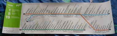
Poster, Yarra Trams, "Route poster - Yarra Trams - Routes 1, 8 and 19", 2012
... Trams tramways Yarra Trams Routes Maps North Coburg Moreland ...Full colour poster printed on a vinyl plasticized based with adhesive backing sheet titled "Route poster - Yarra Trams - Routes 1, 8 and 19." Gives a map layout for the three routes, most stops, shows the Melbourne CBD, connecting services, Yarra trams logo, accessible stops. On right hand end, has the poster details and date of November 2012.trams, tramways, yarra trams, routes, maps, north coburg, moreland, toorak, south melbourne