Showing 92284 items
matching tambo-shire-history
-
 Eltham District Historical Society Inc
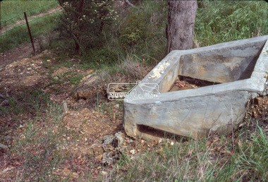
Slide - Photograph, Eltham Shire Council, Unidentified rural road within the Shire of Eltham, c.Nov. 1980
35mm colour positive transparency Kodak Kodachrome cardboard mountProcessed Nov 1980infrastructure, rural areas, rural road, unidentified -
 Eltham District Historical Society Inc
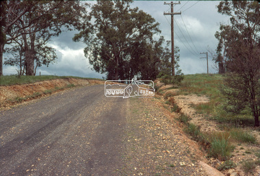
Slide - Photograph, Eltham Shire Council, Unidentified rural road within the Shire of Eltham, c.Nov. 1980
35mm colour positive transparency Kodak Kodachrome cardboard mountProcessed Nov 1980infrastructure, rural areas, rural road, unidentified -
 Eltham District Historical Society Inc
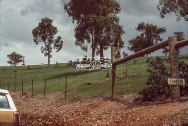
Slide - Photograph, Eltham Shire Council, Unidentified rural road within the Shire of Eltham, c.Nov. 1980
35mm colour positive transparency Kodak Kodachrome cardboard mountProcessed Nov 1980infrastructure, rural areas, rural road, unidentified -
 Eltham District Historical Society Inc
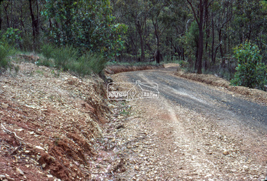
Slide - Photograph, Eltham Shire Council, Unidentified rural road within the Shire of Eltham, c.Nov. 1980
35mm colour positive transparency Kodak Kodachrome cardboard mountProcessed Nov 1980infrastructure, rural areas, rural road, unidentified -
 Eltham District Historical Society Inc
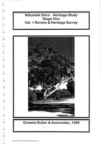
Document, Nillumbik Shire Council, Nillumbik Shire Heritage Study Stage One Vol. 1 Review & Heritage Survey, Graeme Butler & associates, 1996, 1996
Provide the foundation for future planning assessments in the shire76 A4 pages (single sided), spiral bound with clear pastic front and covers.ISBN 0 646 294547nillumbik shire heritage study, graeme butler -
 Eltham District Historical Society Inc
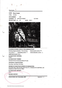
Document, Nillumbik Shire Council, Nillumbik Shire Heritage Study Appendix 1, Graeme Butler & Associates, 2001, 2001
Provide the foundation for future planning assessments in the shire86 A4 pages (double sided) pages (photocopied) no binding or covers. Title page and pages 1, 74,75 and 76 missingnillumbik shire heritage study, graeme butler -
 Eltham District Historical Society Inc
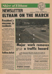
Journal - Newsletter, Shire of Eltham, Shire of Eltham newsletter, 1979
Articles, some with photos. Subjects include President's message, Eltham-templestowe intersection, indoor recreational centre, Bridge over Watsons Creek, town square, list of councillors, forward planning, recreational faciliaites including Eltham town park, Hurstbridge hall, roads, community welfare services, eltham Community and reception centre opening, amenities for youth, concrete bridge at Arthurs creek and Mitton's Bridge at St Andrew's Newsprint, 4 pages harry gilham collection, intersection, round-about, recreation, recreational centre, watsons creek, town square, councilors, newsletter, planning, parks, hurstbridge hall, community welfare service, roads, eltham community and reception centre, youth, skateboard track, mitton's bridge, arthur's creek, fitzsimons lane, main road, road construction, rondabout -
 Greensborough Historical Society
Booklet - Report, TTM Consulting Pty Ltd, Shire of Diamond Valley: Greensborough District Centre: "East-side" development application: traffic & parking impact report, 1992, 1992_04
A summary of traffic ad parking impacts of the Greensborough District Centre in 1992, with plans for the development of the East side of Main Street Greensborough.14 pages text and 11 pages black and white line drawings. greensborough district centre, main street greensborough, traffic, parking -
 Greensborough Historical Society
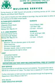
Leaflet, Notice to residents: mulching service, Shire of Diamond Valley, 1990
Notice informing residents of a mulching service located at A. K. Lines Reserve and Eltham North Reserve on selected Sunday during March, April and May 19901 p. printed in green on off-white paper shire of diamond valley, mulching -
 Greensborough Historical Society
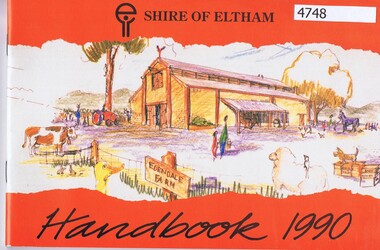
Booklet, Shire of Eltham handbook 1990, 1990_
52 p., mainly black and white, photographsshire of eltham, eltham -
 Eltham District Historical Society Inc
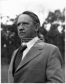
Photograph, Councillor B.T. Taylor, Central Riding, Shire of Eltham, c.1971
Benjamin Thomas Taylor, a resident of Eltham, was a Civil and Mechanical Engineer (CME). He was a Councillor for the Central Riding 1970-1972This photo forms part of a collection of photographs gathered by the Shire of Eltham for their centenary project book,"Pioneers and Painters: 100 years of the Shire of Eltham" by Alan Marshall (1971). The collection of over 500 images is held in partnership between Eltham District Historical Society and Yarra Plenty Regional Library (Eltham Library) and is now formally known as the 'The Shire of Eltham Pioneers Photograph Collection.' It is significant in being the first community sourced collection representing the places and people of the Shire's first one hundred years.Digital image only (no print or negative)sepp, shire of eltham pioneers photograph collection, eltham, cr. b.t. taylor, benjamin thomas taylor, central riding -
 Eltham District Historical Society Inc
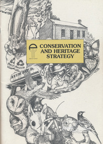
Book, Conservation and Heritage Strategy / Shire of Eltham, 2014
viii, 54 p. : ill., map ; 30 cm. -
 Koorie Heritage Trust
Book, Banfield, Lorna. L, Shire of Ararat Centenary: It's settlement and development 1864-1964, 1964
5-78 p.; ports; tables; maps; bib.; 25 cm.ararat shire-history -
 Stawell Historical Society Inc
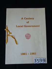
Book, Shire of Stawell, A Century of Local Government 1861-1961 - Shire Stawell, 1961
stawell -
 Eltham District Historical Society Inc
Document, Nillumbik Shire Council, Nillumbik Shire Heritage Study Stage Two, Significant Places, Graeme Butler & associates, 1997, 1997
Contents: Introduction Background Tage Two Team Significance Criteria Community Contacts Citation Structure List of Heritage Places Heritage Place Citations Appendices: Themes Criteria BibliographyProvide the foundation for future planning assessments in the shire106 A4 pages (single sided) pages (photocopied) no binding or covers. Appendices page 15 missing and Appendices page 16 a copy of a damaged pagenillumbik shire heritage study, graeme butler -
 Greensborough Historical Society
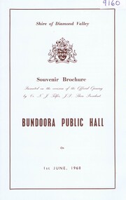
Booklet, Shire of Diamond Valley, Shire of Diamond Valley Souvenir Brochure, Bundoora Public Hall, 01/06/1968
Official souvenir program of the opening of the new Bundoora Public Hall on 1st June, 1968 with photos of the old and new Hall.HistoricBooklet, with sepia text and photos and diagram on card and envelopebundoora hall, shire of diamond valley -
Lakes Entrance Historical Society
Book, East Gippsland Shire, East Gippsland Shire draft Local Law Policy 1999, 1999
This document butlines community local law under part 6 of the local government act 1989 and part 3 of the domestic feral and nuisance animals act 1994 also draft local law policy guidelines East Gippsland Victoriaanimals, environment, health services -
Lakes Entrance Historical Society
Book, East Gippsland Shire Council, East Gippsland Shire Proposed Environmental Strategy 2008, 2008
A report of the proposed environmental strategy resulting from an extensive consultation process with various agencies having an environment profile East Gippsland Victoriaenvironment, waste disposal, water supply -
 Eltham District Historical Society Inc
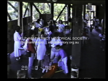
Film - Video (VHS), Eltham Shire Council, Eltham Shire Council - Children's Function - Eltham Community Centre, 66 Susan Street - Building Mud Brick Cubby House (Series 69, Item 3), 29 Oct 1987
VHS Video cassette Converted to MP4 file format 00:38:22; 2.72GBeltham shire council, shire of eltham, video recording, shire of eltham archives, eltham community centre, mud brick, children's activities -
Stawell Historical Society Inc
Medallion, Victoria Jubilee 1887 Shire of Stawell, 1867
Commemorative item of Queen Victoria's Jubilee. Issued by Stawell shire. May have been given to school Children.Tarnished Medallion "Brass"Obverse - Victoria Jubilee 1887 - Young Head Left Profile. Reverse - Shire of Stawell T.H. Hutchings J.P President [Raised engraving of the Shire Hall]queen victoria jubilee -
 Greensborough Historical Society
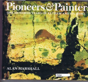
Book, alan marshall, Pioneers & painters: one hundred years of Eltham and its Shire, 1971_
Hardback, 144 p. colour and black and white illustrations, dust jacketnon-fictioneltham, shire of eltham, artists -
 Orbost & District Historical Society
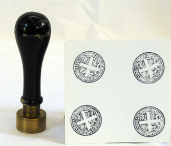
Council Seal
This item was used as a seal (stamp) on official Shire Council documents. The coat of arms of the Shire of Orbost was designed in the form of a cross in which five stars are depicted on a shield. A small crown above the cross indicates the loyalty of the president,councillors and ratepayers to the reigning monarch. The inner section of the shield contains 4 figures, a sheaf of wheat, a factory, a co and a ship - all representing the activities of agriculture, fishing,industry and dairying undertaken in the shire. Originally part of the Bairnsdale district, Orbost split away as part of the Tambo Shire in 1882, and became a shire in its own right as the Shire of Croajingolong on 30th May,1892. The name was changed to the Shire of Orbost on 17th February, 1893. The Orbost Shire Council was abolished on 2nd December, 1994 as part of a state-wide program of local government reform to become part of the newly constituted East Gippsland Shire council.Local governments play an important role in the lives of citizens in Australia. Local government authorities exist to provide services and amenities to local communities, and are also responsible for regulating and providing services for land and property in their district. This item is representative of a time when Orbost had its own Shire Council.The former Orbost Shire Council Seal (stamp) depicting the coat of arms. The circular seal is brass and has a wooden handle with a bulb shaped top.President, Councillors and Ratepayers of the Shire of Orbost-1892orbost orbost-shire-council government history seal -
Federation University Historical Collection
Book, The Pyreness Shire, Avoca Shire Heritage Study 1864-1994, Volume 1, 1995
The Pyreness Shire, Avoca Shire Heritage Study 1864-1994, Volume 11) 21008.1 - Volume 1 - Pale blue bound book of 47 pages - Environmental History 2) 21008.2 - Volume 3 - Pale blue bound book - Geographical Locations of Individual Sites, alphabetically by Road Namewendy jacobs, karen twigg, nigel lewis/richard aitken pty ltd, shire of avoca, avoca heritage study, national estate committee (victoria), national estate grants program, victorian goldfields, pyrenees, moonambel, natte yallock, rathscar, barkly, redbank, crowlands, landsborough, the pyrenees shire, lexton shire, exploration and pastoralism, gold, water, farming, wine and fruit, towns and settlements, living in community, road and rail, extractive industries, conclusion, ballarat, major mitchell, djadja wurrung aboriginal group, djab wurrung aboriginal group, avoca, lamplough, chinese camp, alluvial mining, ironbark mine, upper homebush, homebush deep lead mine, avoca and district historical society, deep leads, quartz mining, percydale, hog's reef mine, avoca, dredging, hunter's home, moonambel c. 1890, mrs ellen allan, lamplough, the 1865 land act, flour milling, flour mill, moonambel. c. 1880, harkins farm, bung bong c. 1900, dairying, viticulture, navarre, schools, churches, cemetaries, wars, hotels, halls, sports, horse racing, country fire authority, maryborough-avoca railway, cobb and co -
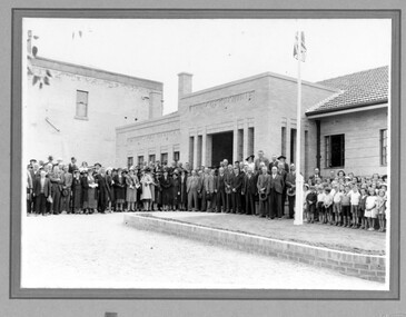 Linton and District Historical Society Inc
Photograph, Hornby Studio Ballarat, Crowd outside new Shire of Grenville building for opening of new Shire Offices in 1939
Black and white photograph of a crowd of men, women and children posed outside a brick building."New Shire hall".buildings, grenville shire council, shire offices linton, events -
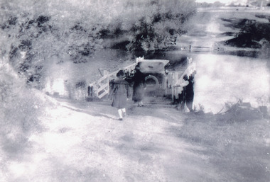 Lakes Entrance Historical Society
Photograph - Tambo Upper Punt, 1920
Black and white photograph showing two females and one male and car using punt to cross river, Punt man loosening guide chains in preparation for crossing. Shows both banks of Tambo River at Tambo Upper Victoria waterways, transport -
Clunes Museum
Financial record - LEAFLET, Shire of Talbot & Clunes
The Shire of Talbot & Clunes is now part of Hepburn ShirePrinted leaflet containing information about the Shire of Talbot & Clunes Council's financial revenue and expenditure, (Ratepayer Report 1973)ratepayer's report, shire of talbot & clunes -
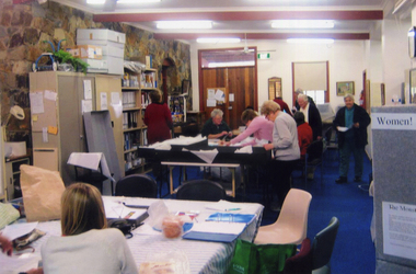 Whitehorse Historical Society Inc.
Photograph, Whitehorse Historical Society - Costume Working Bee, 1/08/2008 12:00:00 AM
Coloured Photo of Whitehorse Historical Society members in the Local History Room during the Costume Working Bee in August 2008.costume working bee, whitehorse historical society inc -
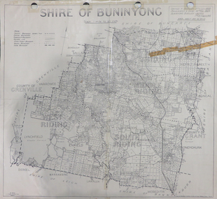 Federation University Historical Collection
Map, Shire of Buninyong, c1970
The Shire of Buninyong was located on the southern side of Ballarat.Two maps of the Shire of Buninyong. .1) Map showing the County divisions, township boundaries, Railway line, State Forest boundary, riding boundary and shire boundary. Identifying words have been added in red and green texta. .2) Shire of Buninyong Parish Plan. Includes Buninyong, Clarendon, Narmbool, Enfield, Lychfield, SCotchman's, Navigators, Warrenheip, Scotsburn, mr Doran, Durham Lead, Cambrian Hill, Napoleons, Garibaldi, Mt Clear, Lal Lal, Bonshaw.1) B.I.A.E., St Martin's, cemetery, mt Buninyong, mt Innes, rly stn shire of buninyong, buninyong, clarendon, narmbool, enfield, lychfield, scotchman's, navigators, warrenheip, scotsburn, mt doran, durham lead, cambrian hill, napoleons, garibaldi, mt clear, lal lal, bonshaw, state forest, elaine, elaine north, cargerie, grenville, mt mercer, millbrook, wallace, yendon, canadian, kaolin deposits, mount helen campus -
 Stawell Historical Society Inc
Photograph, Stawell Shire Hall 1866
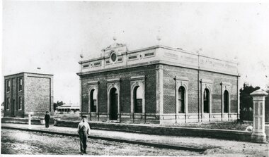
This photograph is a copy obtained from State Library of Victoria. The photograph is of Stawell Shire Hall. Two persons can be seen in the foreground. The two story brick building beside the Stawell Shire Hall was once the Literary Institute. The Stawell Shire Hall building has been added to over the years. Ronald Campbell, the Shires second president laid the foundation stone on 28th April. 1866. The contractors were Hutchings and Delbridge. The photograph shows the first hall and office. The building contained simple 18 feet square rooms, with an entrance hall separating them, the facade was almost as it is now. The initial cost of the Shire Hall was $502.Black and white photograph of Stawell Shire Hall as one single storey brick building with parapet on top. Beside the Shire Hall is a two storey brick building. Also, a dwelling between the two building in the background in Cooper St. Two persons in the foreground, one on the road the other on the pathway. stawell -
 Rutherglen Historical Society
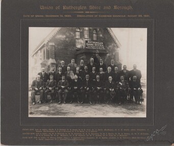
Image, Alf L. Bowden, The Studio, Union of Rutherglen Shire and Borough, 1920 (Exact)
Copy of a photograph of Wesleyan Church used as temporary Shire Office during building of new office. Group portrait of Councillors in front of building."Union of Rutherglen Shire and Borough / Date of Union: December 15, 1920. Dissolution of Combined Councils: August 25, 1921. Rutherglen Shire Office. The Secretary Attends Monday & Friday 10am till 4pm" Front row (left to right) Ex. Cr. S.P. Gollings, Cr. R. Ready, Cr. E.E. Cock, Cr. J. Burch (Ex Mayor), Cr. C.H. Morris (Shire President), J. Hiskins (Ex President), Cr. R.J. Burrowes, Cr. D.B. Smith, Cr. P. Gullifer / Centre Row (left to right) Cr. H.G. Richards, Cr. W.H. Chambers, Cr. R.H. Berryman, Cr. R.J. Harvie, Cr. W.R. McRae, Cr. W.V. McDonald, Cr. C.L. Dobbin, Cr. R.A. McLaurin, Cr. P.M. Seymour, Cr. M.T. Graham, Cr. F. Fuge, Cr J. Milthorpe / Back Row (left to right) T. Trenen (Editor "Sun"), P. Lingford (Shire Engineer), W.C. Bayliss (Banker), A.H. Thompson (Shire Secretary, A.C. Carter (Inspector), N.F. Turnbull (Assistant Secretary)"