Showing 112630 items
matching tracks/roads
-
 National Wool Museum
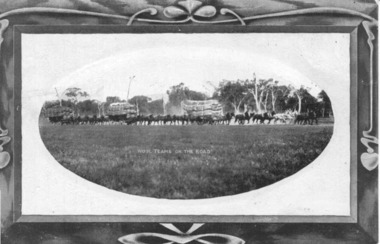
Postcard, Wool Teams on the Road
Postcard produced by 'H&B' and posted in 1909. Depicts horse drawn wagons loaded with wool bales.Postcard, "Wool Teams on the Road", 1909.WOOL TEAMS ON THE ROADwool - transportation -
 Chelsea & District Historical Society Inc
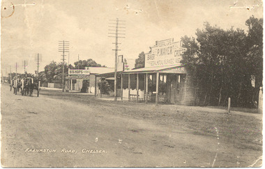
Photograph - Chelsea, Shops, c 1915
Black and white postcard of the main road, Chelsea (now Nepean Highway) showing P. Mayer's Store and Bishop's Store. Bishop's store is on the corner of Wimbourne Avenue, Chelsea. The road is unmade and two wagons are traveling down the road.Frankston Road, Chelseachelsea, mr p. mayer, mr bishop, wagons -
 Phillip Island and District Historical Society Inc.
Photograph, circa 1900
Foreground track leading down to two jetties and shed of San Remo Harbour. Near shed a covered wagon. Coal boat at end of jetty. Large shrubbery on left of picture. Phillip Island foreshore across Westernport in background.Track leading to passenger and coal jetties, Phillip IslandPhillip Island from San Remo Harbourlocal history, photography, photographs, slides, film, san remo harbour, jetties, black & white photograph, miss elms san remo -
 Glen Eira Historical Society
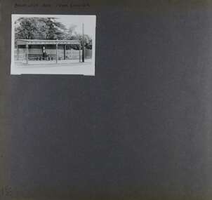
Album - Album page, Balaclava Road Tram Shelter, Circa 1972
This photograph is part of the Caulfield Historical Album 1972. This album was created in approximately 1972 as part of a project by the Caulfield Historical Society to assist in identifying buildings worthy of preservation. The album is related to a Survey the Caulfield Historical Society developed in collaboration with the National Trust of Australia (Victoria) and Caulfield City Council to identify historic buildings within the City of Caulfield that warranted the protection of a National Trust Classification. Principal photographer thought to be Trevor Hart, member of Caulfield Historical Society. Most photographs were taken between 1966-1972 with a small number of photographs being older and from unknown sources. All photographs are black and white except where stated, with 386 photographs over 198 pages. From Victorian Heritage Database citation H0174 TRAM VERANDAH SHELTER CORNER BALACLAVA AND ORRONG ROADS CAULFIELD NORTH - Vic Heritage Register https://vhd.heritagecouncil.vic.gov.au/places/2721 (as at 28/10/2020) The waiting shelter at the corner of Balaclava Road and Orrong Road, Caulfield was constructed in 1916/17 for the Prahran and Malvern Tramways Trust and is one of only three remaining tram shelters in Melbourne designed in the form of a verandah. The shelter has a corrugated iron roof fixed to an angle iron roof frame. The roof, which extends in the form of a skillion over the pavement, is supported on three squared, chamfered timber posts at the rear and three cast iron reeded columns with round bases and Corinthian capitals at the front. (The columns are hollow and function as downpipes, with rainwater discharging from the verandah roof, through the columns and under the ground). The shelter has a rinceau pattern frieze along the road frontage with centrally placed shield motif (which does not contain a coat of arms). The side and rear panels are lined with ripple iron and the upper panel at the rear is lattice work. The shelter has two timber slatted bench seats.From Victorian Heritage Database citation for H0174 TRAM VERANDAH SHELTER CORNER BALACLAVA AND ORRONG ROADS CAULFIELD NORTH - Vic Heritage Register https://vhd.heritagecouncil.vic.gov.au/places/2721 (as at 28/10/2020) How is it significant? The waiting shelter at the corner of Balaclava Road and Orrong Road, Caulfield is of historical and architectural significance to the State of Victoria. Why is it significant? The waiting shelter is of historical significance for its association with the development of the suburban (electric) tram network which assisted the expansion of Melbourne as a suburban metropolis. It is also of historical significance for its connection with the Prahran & Malvern Tramways Trust. The Prahran & Malvern Tramways Trust (1907-1920) was the first municipal electric tramway in Melbourne, becoming the largest and most successful of all the municipal tramway trusts. Its services played a key role in facilitating suburban expansion and the development of the southern and eastern suburbs. The growth of tramways was one of the greatest municipal developments in Victoria during the first decade of the twentieth century. The waiting shelter is an important remnant of this period of Melbourne's transport history and a tangible reminder of the Prahran & Malvern Tramways Trust. The shelter indicates the extent of the Prahran & Malvern tram network. The waiting shelter at corner of Balaclava Road and Orrong Road, Caulfield is one of only three remaining tram shelters in Melbourne designed in the form of a verandah. The waiting shelter is of architectural significance for the distinctive design and construction which is unique to the Prahran & Malvern Tramway Trust tram network. The shelter was designed by notable Melbourne architect Leonard J. Flannagan (1864-1946). Flannagan was responsible for a number of buildings for the Prahran and Malvern Tramways Trust including the early waiting shelter at the junction of Dandenong Road and Hawthorn Road, Caulfield, and sections of the tram depot at Malvern, and also designed a depot for the Hawthorn Tramways Trust. The waiting shelter, a conservative design influenced by Victorian architecture, is based on the Melbourne City Council late 19th century standard cast iron verandah. It is of significance as an intact example of the cast iron type shelter and for its detail, including Corinthian columns and a 'rinceau' pattern cast-iron frieze. The shelter is largely in keeping with the original design and retains its integrity. The cast iron waiting shelter is also of significance as an unusual example of early twentieth century street architecture. Page 155 of Photograph Album with one landscape photograph of a tram shelter on Balaclava Road.Handwritten: BALACLAVA ROAD TRAM SHELTER [top] / 155 [bottom left]trevor hart, verandah, garden, grimwade house, grimwade, orrong road, balaclava road, melbourne grammar, melbourne grammar junior school, mgs, m.g.s, school, tram shelter, waiting shelter, prahran & malvern tramway trust, leonard j. flannagan, cast iron verandah, cast iron type shelter, corinthian columns, 'rinceau' pattern cast-iron frieze, rinceau, cast iron frieze, victorian style, caulfield north, leonard flanagan, cast iron work, prahran and malvern tramways trust, trams -
 Melbourne Tram Museum
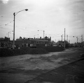
Photograph - Commissioning Queensway tram line, Warren Doubleday, 18-10-1968
Photos show the commissioning or testing of the tram track between Chapel St and St Kilda Junction by W7 940 on 18-10-1968. The first tram travelled on the outbound or down line, rather than the inbound or up line. 1 - At Chapel St 2 - climbing up to St Kilda Junction 3 - At St Kilda Junction with the track on the left side of the photograph being the track in use at the time to bypass the new work.Yields information the commissioning of new track at St Kilda Junction.Set of three Black and white photographs of the commissioning of tram tracks between Chapel St and St Kilda Junction.Has details on rear in blue ink.tramways, trams, tram 940, new tramway, track work, st kilda junction, chapel st, commissioning -
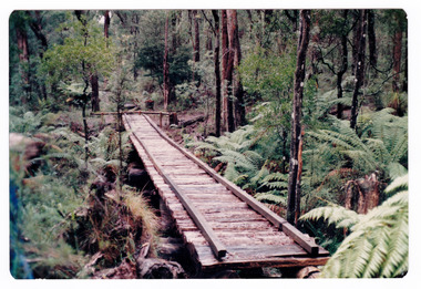 Marysville & District Historical Society
Photograph (item) - Colour photograph, Doug Orford, Unknown
A colour photograph of the timber tramway bridge along the Michaeldene Walking Track near Marysville in Victoria.A colour photograph of the timber tramway bridge along the Michaeldene Walking Track near Marysville in Victoria. The Michaeldene Trail to Taggerty River Lookout is a 4.3 kilometer lightly trafficked loop trail located near Marysville, Victoria. The track is one of several walking tracks located in and around Marysville in Victoria.Doug ORFORDtimber tramway, michaeldene walking track, marysville, victoria, walking track -
Marysville & District Historical Society
Document (Item) - Document-Table, Judith Vimpani, Yarra Track Hostelries- Marysville to Woods Point, Unknown
A document outlining all the hostelries that existed along the Yarra Track between Marysville and Wood's Point.A document outling all the hostelries that existed along the Yarra Track between Marysville and Wood's Point.yarra track, marysville, wood's point, woods point, fernshaw, paradise plains, black spur, mount grant, george edwards, walker family, melbourne, new chum, hit & miss restaurant, mr clifford, michael woods, glen watts, tri bhean hotel, ewen cameron, ewen hugh cameron, thomas barton, butler's wood's point directory, globe hotel, swanston street, mount juliet, ben more & c, jordan district, jefferson's watts bridge inn, matthew jefferson, reefer's hotel, boyle's hotel, william henry johnson, samuel boyle, black spur hotel, fisher's creek, narbethong, fisher's home hotel, black spur inn, frederick fisher, william hodson, wood's point road, acheron river, acheron bridge hotel, john robson, granton, clifford, wilks creek, wilks creek hotel, patrick maloney, steavenson, marysville hotel, australian hotel, junction hotel, the dutchman's restaurant, henry kuyper, william podlech, mount arnold, mount arnold hotel, charles schultz, james toohey, john gleeson, joy burchall, ian newman, henry brockman, belle isle, belle elle, bellell creek, upper yarra, guerin's bridge, bell's hotel, henry petty, celia moran, ruth petty, cumberland creek, cumberland creek store and restaurant, cumberland creek hotel, charles edwin hargreaves, annie hargreaves, urina hargreaves, alice hargreaves, healesville, josiah hargreaves, henderson drysdale, henry whelan, halfway house, thomas smith, svendson, gosling, donovans creek, chesterville, perry's hotel, john perry, perry's coach and horses hotel, edward courtney, scandinavian hotel, the swede's, walker's hotel, jacob burchart, golden fleece, theodore kappler, george koehler's hotel, david walker, millicent walker, elsie jowett, bill walker, big river, royal mail hotel, shaw's, slingsby davies, edwin jones, elizabeth jane parker, sandridge, archibald charles edwin jones, matlock, alexander myers, frank berwick frederick jones, ned jones, jennie jones, sophie milllicent parker jones, thomas shaw, dorothy walker, travellers rest hotel, reefton, summers, john fehring, f fehring, katerina fehring, john christoph blumeyer, anne fehring, john baker, evelyn observer, anna katrina baker, hannah catherine baker, john frederick baker, mcmahon's creek, oaks, the springs, st clair, sinclair's valley, mountain home hotel, neilson, collins, waters, jan emma sinclair, john sinclair, mr cox, peter sinclair, willie we have missed you hotel, spring vale hotel, robert matthews, thomas crawford -
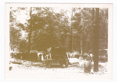 Marysville & District Historical Society
Postcard (item) - Black and white postcard, Marysville & District Historical Society Inc, Bullock Teams at the Dump, Woods Point Road, 1993
A black and white photograph of bullock teams at the Log Dump at on the Wood's Point Road.A black and white photograph of bullock teams at the Dump at on the Wood's Point Road. The Marysville-Woods Point Road was originally part of the Yarra Track, constructed in the early 1860s to provide access between Healesville and the Woods Point Goldfields. Despite the steep terrain and engineering difficulties, the Yarra Track soon became a busy route used by pack horses, horse-drawn drays, and wagons. Today this sealed mountain road is a popular scenic drive between Marysville and Warburton. This postcard was produced by the Marysville Historical Society as a souvenir of Marysville.YESTERYEAR POSTCARDS AFFIX/ STAMP/ HERE BULLOCK TEAMS AT THE DUMP,/ WOODS POINT ROAD. C Marysville Historical Society, 1993marysville, bullock teams, woods point road, victoria, marysville historical society, postcard, souvenir, yesteryear postcards, marysville-wood's point road, yarra track, healesville, mining, timber mills, warburton -
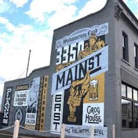 City of Ballarat
Artwork, other - Public Artwork, Travis Price, Main Road Mural by Travis Price, May 2018
Whilst my main focus for the artwork design was on the Hotels on Main Road, I felt there was an opportunity to tell a broader story of Main Rd and combine/include some interesting pieces of information from many stages of the history of Main Road. Considering that at one point in time there would have been at more than six hotels in this very short section of street….there’s no doubt Main Rd was an epicentre of communication and festivities for the Goldfields of Ballarat. “No matter what luck he had, every miner needed supplies, food and something to entertain him when he was not searching for gold.” Described as being an overcrowded jumble of muddy streets loosely arranged around mining camps...and loud, muddy, colourful and sometimes illicit. I wanted the artwork composition to consist of overlapping images and text to reflect this sense of hustle and bustle. Main Road Mural tells the broader story of the history of Main Road in Ballarat. In 2018, the City of Ballarat commissioned local Ballarat artist Travis Price to create an artwork to align with the Main Road Revitalisation Project and deliver a key component of the storytelling (heritage interpretation) project that spans the length of the shopping precinct. The artwork is featured on a prominent site in the shopping precinct of main road and tells the story of Main Road through depicting key timeline events. Main Road, as its name suggests, was one of the main entries to the mining areas of East Ballarat. It had several names: Main Street before 1858, Plank Road between 1858 and 1868 and Main Road from 1868 onwards. The centre of mining life, it was crowded, prosperous, raucous and dirty. Painted mural on shop wall in Main Road, BallaratBallaarat, Gold Fever, The Royal Standard Hotel, Flood, Boxing Saloon, Plank Road, Kulin Nation, 3350, Election, East, Grog House, The Scandinavian Hotel. Images; Chinese lantern, Pick & Shovel, Miners Licence burning.main road history, ballarat hotels, gold fever, wadawurrung, kulin nation -
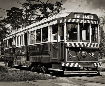 Ballarat Tramway Museum
Photograph - Ballarat 38 - BTM, Greg Naylor, 2022
Black and White photo of Ballarat 38 - BTM on depot access track. See reference for the history of this tram. Photographed during 2022 on a Mamiya RB67 large format film camera.Yields information about BTM tram 38.Black and White photo of Ballarat 38 - BTM on depot access track.btm, trams, tramcars, tram 38 -
![Construction of the electric tram line in Cotham Road [Kew]](/media/collectors/550653872162f11fb04854aa/items/6628917c6214a76cee3ee29e/item-media/662891d96214a76cee3eeacb/item-fit-380x285.jpg) Kew Historical Society Inc
Kew Historical Society IncPhotograph - Construction of the electric tram line in Cotham Road [Kew], E.J. Dower, 1913
One of a small album of six photographs of the construction of the Cotham Road tramline in Kew, taken by Edgar James Dower in the second decade of the twentieth century. The reverse of each photo contains notes, written over time by the photographer, which are contained in the 'Inscriptions' field. Born and raised in Olinda, Dower's family later moved to Surrey Hills. He worked as an adult as a clerk in the city office of the Metropolitan Gas Company, and in his role as a 'collector', he was able to photograph scenes including the construction of tram and train lines and associated buildings in Kew, Hawthorn, Camberwell and Surrey Hills. Later he established a real estate agency with his brother - the E.J. Dower Real Estate Agency, Dandenong Office. The album as a whole can be viewed separately as the parent file.The image is an historically significant record of the development of transport infrastructure which was used to connect Victorians in the first two decades of the twentieth century. This development resulted from increases in population and the consequent extension of Melbourne's suburbs. The photographs in the album, as well as Dower's single photos mounted on card, individually and collectively richly detail the labour of workers and the tools and machinery used to create and extend Melbourne's tram and train networks in the years preceding and during World War 1.The sixth of six annotated photos in an album of photographs of the construction of the St Kilda to Kew electric tram line, taken in Cotham Road, Kew, by the amateur photographer, Edgar James Dower, in 1913. The album contains images detailing the preparation for the laying of the tracks plus work laying the line. The photographer notes on a number of the photos that the metal tracks were collected from the Hawthorn railway siding. The album, together with other phots by E.J. Dower has been made available by the owners for the Kew Historical Society to digitise and publish online and in print.Annotation verso: "Preparing tram line Cotham Road Kew for electric trams / 1913 / The metal was brought by horse and drays, from Hawthorn railway siding".keywords, theme -- connecting victorians by transport and communications, theme -- travelling by tram, photographers -- edgar james dower, cotham road -- kew (vic.) -
Whitehorse Historical Society Inc.
Document, Dorothy Maxwell, 9/05/2005 12:00:00 AM
Interview of Dorothy Maxwell by Valda Arrowsmith.Interview of Dorothy Maxwell by Valda Arrowsmith, about the establishment of the Bill Sewart Athletics Track and the Little Athletics movement.Interview of Dorothy Maxwell by Valda Arrowsmith.bill sewart athletic track, nunawading little athletics club -
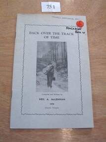 Stawell Historical Society Inc
Book, N.A. McLennan, Back over the track of Time by N A McLennan, 1970
A History of BanyeaGrey Card Cover with border insode of which is text and B/W Photo of a man walking along a track carrying a swag In Blue Ink Underlined: Banyana History Inside Border Back over the Track of Time Compiled and written by Neil A. McLennan 1970 Stawell Victoriastawell, mclennan family -
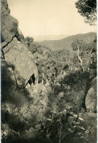 Stawell Historical Society Inc
Postcard, Track to Mackey's Peak Showing Lake Fyans in Distance in the Grampians -- Postcard
Photographic post card of track to Mackey's Peak showing Lake Fyans in distance "The Grampians".Black and white photograph of a bush scene with mountain views.Post Card Kodak Australia written in pencil on the back "The Track to Mackey's peak showing Lake Fyan's in distance".halls gap grampians -
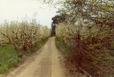 Whitehorse Historical Society Inc.
Photograph, Livermore's Orchard
Coloured photo of track looking south on Livermore's Orchard, Morack Road, Vermontlivermore, douglas, clem, orchards -
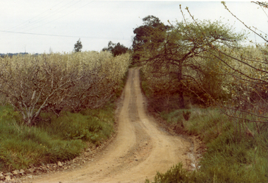 Whitehorse Historical Society Inc.
Photograph, Livermore's Orchard
Coloured photo of track looking south on Livermore's Orchard, Morack Road, Vermontlivermores orchard, orchards -
Tatura Irrigation & Wartime Camps Museum
Photograph, D. Kilmartin Home, 1906
Original photograph of Denis Kilmartin on verandah of his home on Springvale Road Tatura. Now Moulders property. Man with horse possibly his brother.Sepia toned photograph of D. Kilmartin on verandah of his weatherboard home on property at Springvale Road, Tatura.on back: D. Kilmartin homestead, Springvale Road, Tatura. Now Moulders. D. Kilmartin on verandah.denis kilmartin, springvale road tatura -
 Linton and District Historical Society Inc
Leaflet, Grenville Standard Print, Linton, Duties and Responsibilities of Patrol Men
Printed leaflet of four pages setting out working conditions of men employed on main roads by the Country Roads Board. Two copies.Text: " Duties and Responsibilities / OF / PATROL MEN / EMPLOYED ON MAIN ROADS BY THE / COUNTRY ROADS BOARD. "country roads board, employment -
 City of Kingston
Pamphlet - Colour, Farrow Falcon Press, Printers, Ozone Estate, Bluff Road, Hampton, c.1940
Sales plan for land in the suburb of Hampton (Highett), bounded by Bluff Road, Wickham Road, Peterson Street and June Street. Includes Morley Street, Follett Avenue, and Parrett StreetThe developing urban area of Highett within the City of Kingston. This land sale pamphlet illustrates the subdivision of land within the municipality and the changing demographic of the district as new houses are constructed close to infrastructure.Colour pamphlet advertising for private sale the Ozone Estate, Bluff Road Hampton. Incorporates a map of the estate bordered by Bluff Road, Wickham Road, June Street and Peterson Street including Morley Street, Follett Avenue and Parrett Street.Handwritten in grey pencil on reverse: Ozone Printed in purple ink on front top right-hand corner: Vendors are - Leslie Harcourt MacGowan, Esq / Neerim Road, Caulfield / & / Arthur Alfred Parrett, Esq / 311 Flinders Lane / Melbourneland sales, estate, hampton, highett -
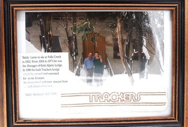 Falls Creek Historical Society
Photograph - "Baldy" Blackwell and Trackers
This photo is from the private collection of George Shirling of Red Onion, Falls Creek. George Shirling arrived in Falls Creek in 1962. He engaged Phil Nowell to build the original Koki Alpine Lodge which opened in 1965 with 14 beds. George operated the lodge with Michael “Baldy” Blackwell as manager. He also graduated in sport psychology in 1981 and was invited to become team psychologist for the Australian Winter Olympic team which went to Albertville, France, in 1992. He later owned the Red Onion Chalet. George credited the success of Koki to “Baldy” Blackwell. “Baldy” and Phil Nowell started the Trackers Mountain Lodge in partnership during the 1980s. In 1971 George sold Koki Lodge to Sigi Doerr. In 2024 the renamed Koki Alpine resort remains a highly popular destination in Falls Creek. George Shirling passed away on 27th February 2023. He had remained actively involved in Falls Creek and was generous with his time and knowledge, always an amazing supporter of The Falls Creek Museum and Falls Creek Village.This photo is significant because it features "Baldy" Blackwell of Trackers Mountain Lodge, Falls Creek, Victoria.A framed photograph of "Baldy" Blackwell standing outside the front of "Trackers". A fabric souvenir patch and a label have been included in the frame.On Label 'Baldy 'came to ski at Falls Creek in 1962. From 1965 to 1971 he was the Manager of Koki Alpine Lodge. In 1980 he built Trackers Lodge which he owned and operated for some 14 years. An always kind and ever sincere host ....well ahead of his time. "Baldy Blackwell" 1937-1995george shirling, "baldy" blackwell, trackers lodge -
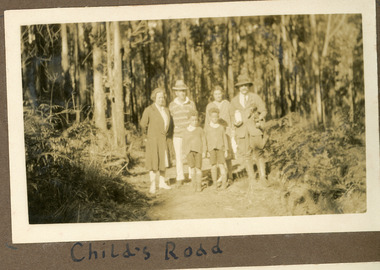 Mt Dandenong & District Historical Society Inc.
Photograph
This photograph is from the album of Ivy Child. It shows her parents Ethel and Ted Child (rhs) standing on Childs Road with another couple and their two young boys. Ivy May Child (1910 – 1989) was the daughter of Arthur Edward (Ted) Child (1878 – 1964) and Ethel May Madden (1888 – 1970). Ted Child was the son of Matthew Francis Child (1839 – 1933) and Martha Jeeves (1857 – 1926). He was the grandson of one of the early pioneers Francis Child. Ivy grew up on the family property on Childs Road and took many photographs. Most of these are glued into her photo album. The album covered the years from c1927 – 1932. Ivy married Henry William Burgess (1906 – 1968) in 1944. The photographs remain in their original state in the album with individual copies made. Sepia photograph showing two men, two women and two young boys standing in the centre of an unmade rad. Ferns and trees are growing up to the edges of the road.Handwritten below the photograph in album: Child's Roadted child, ethel child, childs road, bush -
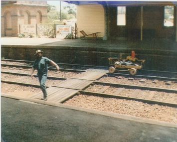 Sunbury Family History and Heritage Society Inc.
Photograph, c 1970
A railway maintenance person is crossing the railway tracks from Platform 2 to Platform 1 at Sunbury Station. There is a partial view of the historic brick water tower, which was used by the steam engines, on Platform 2.A coloured photograph of a maintenance man walking across a railway track at a station.sunbury railway station, water towers -
Marysville & District Historical Society
Document (item) - Research Document, Judith Vimpani, Hermit of the Cumberland Goldfield-George Ernest Locke, 2020
An account of the life of George Ernest Locke who was a gold miner on the Yarra Track near Marysville in Victoria.An account of the life of George Ernest Locke who was a gold miner on the Yarra Track near Marysville in Victoria. George was a well-educated young man and had some success prospecting in the Cumberland area before partnering with William Chester with whom he opened the Golden Bower gold mine in 1896. George and William then discovered a second reef which they named the Silver Bower mine. George lived in a log cabin in the Cumberland reserve and was known to be a loner. He was clever with his money and chose not to have a bank account in Marysville, where everyone would learn about his financial status. He banked at the ES&A in Fitzroy and at the time of his death in 1941 he had accumulated the princely sum of three hundred and sixty pounds. George Locke was known as "the Hermit of Cumberland Valley" and lived in his humpy until his last few days during which he moved into a Forest Commission's patrol hut because his old humpy had started to fall to pieces. When George passed away at the age of 81 years he had not visited Marysville for over 14 years. george ernest locke, gold miner, gold mining, yarra track, william chester, golden bower mine, cumberland goldfield, silver bower mine, chesterville, marysville, victoria, jackie lewis, baron somers, big tree, picea sitchensis exotic, box hill cemetery, john edward locke, annie caroline locke, hermit of the cumberland valley -
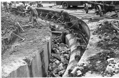
 Melbourne Tram Museum
Photograph - Black and White - demolishing cable tram track Smith St and Queens Parade 1954/55
The photograph shows the demolition or removal of the cable tram track at the intersection of Smith St Gertrude St. Fitzroy. The workmen are excavating the former cable tram track The inbound cable tram track remains in position. The 1955 Annual Report notes that work commenced following the completion of the Queen's visit in March 1954 and that all work was done by day-labour. The track was opened to service in late June 1955. The second image is from a Melbourne and Metropolitan Board of Works plan (part) No. 1217 - Collingwood for the intersection, obtained for reference from the State Library of Victoria Collection of MMBW Plans. It shows the layout of the cables and the large sheave pit that the cable itself passed around. The trams were required to drop the cable from the grip prior to the entry to the curve and then coast around. Photographer is possibly Keith Kings.Yields information about the extent of work need to convert the former Northcote Cable tram route to Electric trams, the people and the methods used to undertake the work.Photograph - Black and White of the demolition of the cable tram track at the corner of Queens Parade - Smith St Clifton Hill.trams, tramways, cable trams, workmen, mmtb, demolition, track work, conversion, smith street, queens parade, clifton hill -
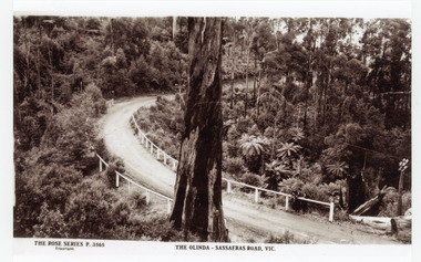 Mt Dandenong & District Historical Society Inc.
Photograph, The Olinda-Sassafras Road, Vic
Rose Series post card # P. 3565 showing the Sassafras - Olinda Road taken outside Rostrevor Guest House. Photograph taken pre 1920 prior to the pine plantation planted by Melbourne High School.Black and white copy of Rose Series post card P. 3565 showing a section of the Olinda - Sassafras Road with a large tree in the foreground.On Front: THE ROSE SERIES P. 3565 THE OLINDA - SASSAFRAS ROAD. VIC.sassafras-olinda road, sassafras, olinda, rostrevor, post card, the rose series, rose series -
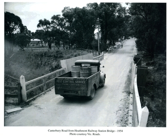 Ringwood and District Historical Society
Photographs / Album Pages, Canterbury Road from Heathmont Railway Station Bridge 1954, 1954
Houghton & Byrne Pest Service Truck on Canterbury Road crossing Heathmont Railway Station Bridge 1954. Photo courtesy Vic. RoadsCanterbury Road from Heathmont Railway Station Bridge - 1954. Photo courtesy Vic. Roads -
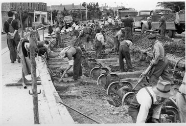
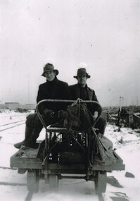 Otway Districts Historical Society
Photograph, Woosnan, Frank, Track gang at Beech Forest, c.1940, c.1940
At its peak the Colac-Beech Forest-Crowes railway employed more than 21 staff tending the lines that the trains ran over. Gangers (the men in charge of the track gangs) tended to be promoted into the Otways but many of their subordinate repairers were local recruits. A few of the men who worked on the original construction gangs of 1900-02 remained and obtained positions in the track gangs along the line, but these eased out over time. The track was maintained by seven three-man gangs based at Colac, Barongarook, Gellibrand, Banool, Beech Forest (where the second Beech Forest crew was based at Wyelangta), and Lavers Hill.Track gang on an NK wagon at Beech Forest, c.1940. Snow covers the ground. B/W.colac; beech forest; crowes; railway; track gangs; -
 Melbourne Tram Museum
Photograph - Black and White - demolishing cable tram track Smith and Gertrude Streets 1954/55
The photograph shows the demolition or removal of the cable tram track at the intersection of Smith Street and Gertrude St Fitzroy, 1954/55. Photo shows the workmen excavating and demolishing parts of the massive infrastructure needed at this curve to enable cable trams to pass around the sharp curve, still one of the sharpest on today's Melbourne tram system. The outside cable tram track remains in position. The MMBW plan shows a large cable sheave pit on the outside of the curve. The 1955 Annual Report notes that work commenced following the completion of the Queen's visit in March 1954 and that all work was done by day-labour. The track was opened to service in late June 1955. Photographer is possibly Keith Kings.Yields information about the extent of work need to convert the former Northcote Cable tram route to Electric trams, the people, the extent of the original construction and the methods used to undertake the work.Photograph - Black and White - demolishing cable tram track Smith and Gertrude Streets 1954/55trams, tramways, cable trams, workmen, mmtb, demolition, track work, conversion, smith street, gertrude street, fitzroy -
 Kiewa Valley Historical Society
Maps - Tawonga and Feathertop
Plan of Tawonga showing roads etc, rivers, use of land in 1968 and of Feathertop in 1969.Historical use of land in Tawonga and Feathertop.1. Topographical Map - Tawonga 803 Forests Commission of Victoria 1968. Cream paper with black print. Legend: Roads, tracks etc, rivers, Parishes and use of land. 2. Feathertop 813. 1969tawonga map 1968, tawonga parishes, feathertop map 1969 -
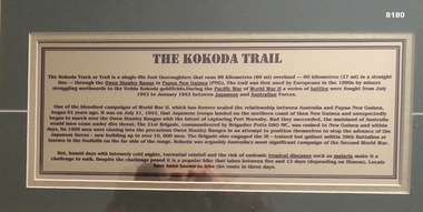 Bendigo Military Museum
Photograph - THE KOKODA TRAIL, FRAMED, Unknown
The description outlines the the Kokoda Campaign from July 1942 to November 1942. The track is 96 K’s or then it was 60 miles over the Owen Stanley Ranges in New Guinea. Australian casualties were 625 KIA, 1600 WIA and a huge 4,000 casualties due to illness. Over the years there has been many discussions as to whether it is a “trail” or a”track”. This item is on display in the Bendigo District RSL Havilah Road.Framed series of photos 13 in all re the Kokoda Track Campaign in New Guinea in 1942. Photos are set in a green background with each photo having a yellowish border. A rising Sun Badge is center near the bottom. At the bottom is a text description of the campaign.brsl, smirsl, bdrslinc, kokoda