Showing 558 items matching "victoria: the garden state"
-
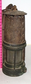 Parks Victoria - State Coal Mine - Wonthaggi
Lamp, C 1960's
Used by miners at SCM to test for gas.Davey Safety Lampon side: EP 82 -
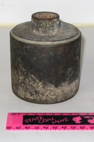
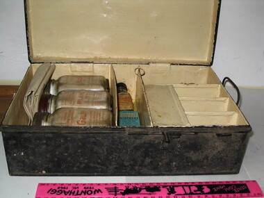 Parks Victoria - State Coal Mine - Wonthaggi
First Aid box
Used for first aid in SCMBlack first aid box with a red cross on the lid. Still has first aid contents inside -
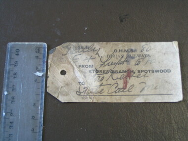 Parks Victoria - State Coal Mine - Wonthaggi
Ticket, Victorian Railways
Railway luggage ticket to ensure that luggage reaches its destination which is the State Coal Mine.Small used railway luggage ticket with inscriptions.Yes -
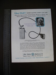 Parks Victoria - State Coal Mine - Wonthaggi
Booklet, Sullivan Machinery Company
Booklet about the Edison Model J Miners Electric Safety Cap Lamp. Small booklet with black and blue text, appears to be the manual for the lamp (SCM 0004) -
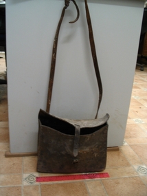 Parks Victoria - State Coal Mine - Wonthaggi
Bag /satchel, C 1900's
Nobby Smith's bag used when out riding his horse fixing fences. Made by Arthur Smales. Nobby Smith worked for almost 30 years at the SCM as a Stable Manager. "Come here! Gee off" Joe & Lyn Chambers December 1991Leather bag / satchel with flap and buckle, long shoulder strap. Side panel stiched with white stitching. -
 Parks Victoria - State Coal Mine - Wonthaggi
Shower rose, State Coal Mine, C 1930's
Shower rose from Kirrak Area change rooms.Steel cylinder with small opening at the top -
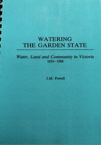 Wodonga & District Historical Society Inc
Book - Watering the Garden State - Water, Land and Community in Victoria 1834-1988, J.M. Powell
This publication traces the importance of water resources to Australian society, with reference to the state of Victoria. It relates the history from 1834 including topics such as community adaptation to settlement planning for squatters, miners, immigrants and colonials; conservation and water management; expansion and consolidation of statutory bodies following the creation of the Department of Water Resources in 1984; and finally the effects of regionalism, environmentalism, urban conflict and institutional reform. It includes an appendix containing a brief chronology of significant events regarding water from 1853 to 1987.Spiral bound booklet with laminated covernon-fiction This publication traces the importance of water resources to Australian society, with reference to the state of Victoria. It relates the history from 1834 including topics such as community adaptation to settlement planning for squatters, miners, immigrants and colonials; conservation and water management; expansion and consolidation of statutory bodies following the creation of the Department of Water Resources in 1984; and finally the effects of regionalism, environmentalism, urban conflict and institutional reform. It includes an appendix containing a brief chronology of significant events regarding water from 1853 to 1987.water resources development, water-supply -- victoria -- history., water victoria -
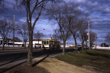 Ballarat Tramway Museum
Slide - Set of 7, Warren Doubleday, Ballarat - last weekday of full operations, 20/8/1971
Photos taken on the last weekday of full operations by the SECV in Ballarat prior to the first closure of the Victoria St line on 22/8/1971. 1 - tram 30 arriving at Victoria St with school children and others alighting. 2 - tram 30 waiting to return to Gardens via Sturt St west. 3 - tram 13 at Stones Corner, Bridge and Victoria St on its way to Victoria St. Has buildings / advertisements for Schonell cycles, Gear chemist, Phillip Howard, The Sun, AVCO, ANZ, Roddas, CS Pennant, Top 4, State Savings Bank and H Whitefield Hair dresser. 4 - trams 30 and 13 crossing at the King St loop in Victoria St. 5 - tram 37 in Sturt St arriving at the City stop 6 - tram 43 southbound in Lydiard St crossing Mair St - note the traffic lights, one of the first installations in Ballarat. Has adverts for Peter's, and Speedee cleaners. 7 - track cleaner with broom with tram No. 12 behind, with the destination of City. Has the Chinese cafe, seafood bar, Kodak advert, Town Hall, and tramway shelter in the view.Yields information about the last full week day of SEC Tramway operations in Ballarat and has a strong association with the archivist. Set of 7 Kodachrome colour slides - cardboard mountsHave the photographer's slide numbers written on them.trams, tramways, closure, depot, victoria st, sturt st, lydiard st, tram 13, tram 30, tram 12, tram 37, tram 43 -
 Port Melbourne Historical & Preservation Society
Audio - PMHPS Meeting, Steve Tserkizidis, Hosuing in Garden City, John Kirby, 27 Jan 2014
PMHPS meeting on 27.01.2014. Steve Tserkizidis talks about housing development in Garden City and Victorian Public Recoprds Office. Duration 01:02:50 (includes meeting preliminaries) .02 - CD of abovebuilt environment - domestic, garden city estate development, public records office victoria, dunston housing estate, state savings bank of victoria, montague housing development -
Kew Historical Society Inc
Journal - Visitor Book, Fairyland Book
"Fairyland", the home of Jim and Grace Tabulo, was a notable local, state and international tourist attraction situated in Kew, Victoria during the mid twentieth century. Located at 57 Malmsbury Street, Kew, the weatherboard house and its garden were heavily decorated with statues, crockery and other collected items. A series of notebooks were used to record the messages of child and adult visitors to the property from the 1940s to the 1960s. After Mrs Tabulo's death, these visitor books are believed to have formed part of the Dorothy Rogers Collection. They entered the Kew Historical Society's collection following Dorothy Roger's death in 1973.This series of visitor books are the most important primary sources relating to the internationally renowned 'Fairyland' cottage in Malmsbury Street, Kew. Their social significance is that they record in the post war period the values and beliefs of children and adults who visited this historically significant tourist attraction.Foolscap size visitor book containing handwritten comments and drawings primarily made by children during visits to the home of Grace Tabulo, c.1950-1960. Commonly known as "Fairyland", the house was located at 57 Malmsbury Street Kew. The book is wrapped in brown paper, which covers back cardboard covers with a red cloth strip binding. Unpaginated, approximately 160 pages, and covers. The book has an additional loosely inserted black card cover located at the front of the book.Handwritten in pencil on paper cover: "1950 - 1962 /(edit book dates)" Handwritten in ink on paper label on loosely inserted cover: "Fairy Land / Book/ September 1950 / Fairy Land / Book / 75 [sic] M...berry [indistinct] st Kew / Fairy Land Book"grace tabulo -- fairyland -- 57 malmsbury street -- kew (vic.), tourism - kew - 1945-1965, childhood - kew, collectors and collecting, gardens - kew (vic), scrapbooks - 20th century -
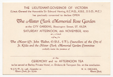 St Kilda Historical Society
Ephemera - Invitation, The Alister Clark Memorial Rose Garden, 1950
Invitation to the official opening of the Alister Clark Memorial Rose Garden at the City Gardens, Blessington Street St Kilda (now the St Kilda Botanical Gardens) on 18 November 1950. Alister Clark was a foundation member of the National Rose Society of Victoria in 1900 and served as its president. He put great effort and skill into developing new varieties that were grown throughout Australia and were highly regarded in the USA. He supplied his new varieties without charge to State rose societies for propagation and sale and won many awards.Cream coloured card printed in brown on one sidealister clark, st kilda botanical gardens -
 University of Melbourne, Burnley Campus Archives
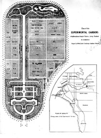
Newspaper - Newspaper Cutting, The Victorian Farmers Journal and Gardeners Chronicle, The New Gardens of the Horticultural Society, 1862
... Chronicle State Library of Victoria Alfred Lynch ...Copy of article in "The Victorian Farmers Journal and Gardeners Chronicle" 21 June, 1862 p 13. Advises lithograph of the new gardens is included. They had hoped to open the gardens on 1st january, 1862 but had insufficient funds to complete the work. Description of grounds.Copy of lithograph see B92.632.the victorian farmers journal and gardeners chronicle, lithograph, gardens, experimental gardens plan, financial difficulties, opening of gardens -
 Hymettus Cottage & Garden Ballarat
Newspaper - MX, There aren't enough hugs to make this pain go away
Marion Taffe was Features Editor for Melbourne's MX commuter newspaper and wrote this feature following the loss of her cousin and family at Kinglake in Victoria's Black Saturday bushfires of 2009. Her article was published in newspapers worldwide.non-fictionMarion Taffe was Features Editor for Melbourne's MX commuter newspaper and wrote this feature following the loss of her cousin and family at Kinglake in Victoria's Black Saturday bushfires of 2009. Her article was published in newspapers worldwide.bushfire, black saturday bushfires, victorian bushfires, kinglake, warnambool, marion taffe, mx, newspaper, davey family -
 Eltham District Historical Society Inc
Photograph - Digital Photograph, Alan King, Eltham Living and Learning Centre, 26 January 2008
In 1857, tanner John Pearson purchased three and a half acres of land in Little Eltham, at the western end of Pitt Street, with a 70-foot frontage to Maria Street (Main Road) and stretching down to the Diamond Creek for £100. He contracted Benjamin Oliver Wallis to build house for him. Wallis, a mason by trade who originated from the Cornish village of Newlyn, migrated to Melbourne in 1853 and was shortly engaged by Richard Warren to build the Eltham Hotel, which opened in 1854. When Warren fell into financial difficulty in 1858, Wallis purchased the hotel. That same year, Pearson constructed a tannery below the house with access to the water in the Diamond Creek. When Pearson became bankrupt in 1867, Wallis similarly acquired the house from Pearson’s creditors in 1868 and lived there until his death in 1896. For some of this time the house was in the name of Wallis’s son Richard but following his death in 1888, ownership reverted to his father. It was purchased by retired teacher Richard Gilsenen in 1899. Gilsenen was made acting head teacher at the Eltham State School in 1906 following the sudden death of head teacher John Brown. In the 1950s the house was bought by retired engineer Dr Alfred Fitzpatrick and his wife Claire who made various modifications to house goats and poultry as well as structural modifications to the house. In the early 1970s, Eltham Shire Councillors Frank Maas and Don Maling proposed an extended communities’ activities program be set up and the Commonwealth Grants Commission was approached for financial assistance. In 1974 a $50,000 Commonwealth Grant was received by the Shire Council to acquire the Fitzpatrick property as part of the planning to establish an extended communities’ activities program. The Fitzpatricks moved next door and Claire taught at the new Living and Learning Centre, which began in 1975, one of the first community education centres in Victoria. Covered under Heritage Overlay, Nillumbik Planning Scheme. Published: Nillumbik Now and Then / Marguerite Marshall 2008; photographs Alan King with Marguerite Marshall.; p59 It’s a centre for sharing knowledge and friendship and it stands on the former hub of Eltham’s original township near Pitt Street. The Eltham Living and Learning Centre, with around 2000 participants a year, began in 1975 as one of the first Community Education Centres in Victoria. Classes ranging from macramé to wine making to environmental living have enriched the lives of thousands of people through the generosity of tutors sharing their skills free of charge. The centre’s heart is the brick cottage, built in 1858 by tanner John Pearson. He bought the three and a half acre (1.4ha) allotment fronting Maria Street (now Main Road) and stretching down to the Diamond Creek. The allotment formed part of a 316 acre (127.8ha) subdivision, owned by Josiah Holloway, called Little Eltham, north of the original Eltham Reserve.1 The allotment then passed through the hands of several speculators before it was sold to Pearson for £100 in 1857. Mr Pearson’s children attended the Eltham Primary School from 1864 to 1867. But creditors took possession of the property when his tannery folded in 1867. It was then sold to publican Benjamin Wallis, who owned the Eltham Hotel at the corner of Pitt Street and Main Road. In 1899 the property was bought by Richard Gilsenan, who became acting head teacher of the Eltham Primary State School in 1906. In the 1950s, retired engineer Dr Alfred Fitzpatrick and his wife Claire bought the property, and made structural changes. Claire, a journalist and community campaigner, modified and built pens for goats and poultry, a stable, a garage and planted fruit trees and a vegetable garden. In the early 1970s a young woman called Carina Hack approached Gwen Wesson at the Diamond Valley Learning Centre (Victoria’s first Community Education Centre) about starting a community centre. Following Wesson’s suggestion, Hack spoke to Shire President Alistair Knox ‘one bleak rainy afternoon, sipping hot drinks and discussing life’.2 Eltham Shire Councillors Frank Maas and Don Maling proposed a community activities program and the council received a $50,000 Commonwealth Government Grant for this venture.3 The Fitzpatricks sold their property to the council and moved next door and Claire taught at the new centre, which Hack named. Eltham obviously wanted such a centre as Hack recalls. ‘During the next two months we had about 50 volunteers working day, night and weekends, scrubbing down, plastering and painting walls, replacing floors, repairing fences, recycling furniture, sewing curtains and cushions, donating furniture, toys, equipment, clean-ing and gardening…’4 The first enrolment day saw a queue stretching up the driveway nearly to the gate and the first sessions attracted 270 people a week. Soon the outbuildings were converted into pottery studios and a large workshop. From 1979 the Eltham Art and Craft Market was held in the centre’s grounds and the Friends of the Centre ran it from 1980. A former program coordinator, Margaret Johnson, remembers enrolment day in the late 1970s and 1980s, when hundreds of people would queue – and some even camped overnight! Overnighters were greeted in the morning with fresh tea and toast. Another tradition was The Enrolment Day Cake with Recipe, given to volunteers. ‘One happy Enrolment Day fell on February 14 and let’s just say that St Valentine found some willing participants, paying $2 for a kiss.’5 Meanwhile the participants’ children could play at the Council Eltham Lower Park house in Hohnes Road, later in Susan Street. But the centre has had difficulties too. In 1990 a fire destroyed the stable and the police suspected arson. However the pavilion was built in its place.This collection of almost 130 photos about places and people within the Shire of Nillumbik, an urban and rural municipality in Melbourne's north, contributes to an understanding of the history of the Shire. Published in 2008 immediately prior to the Black Saturday bushfires of February 7, 2009, it documents sites that were impacted, and in some cases destroyed by the fires. It includes photographs taken especially for the publication, creating a unique time capsule representing the Shire in the early 21st century. It remains the most recent comprehenesive publication devoted to the Shire's history connecting local residents to the past. nillumbik now and then (marshall-king) collection, benjamin oliver wallis, claire fitzpatrick, don maling, dr alfred fitzpatrick, eltham living and learning centre, frank maas, john pearson, richard gilsenen, tannery -
 Eltham District Historical Society Inc
Document, Certificate of Consent of Sale of Lot 20 Henry Street, Eltham to Hope of Eltham Tent No. 195 Victoria District Independent Order of Rechabites, 28 Nov 1901
Alexander Robert Edgar, President of the Victoria and Tasmania Conference of the Wesleyan Methodist Church by Certificate of Consent of Sale dated 28 November 1901, declared that the Conference of the Church held in Melbourne, 27 February 1894, agreed to the sale by the Trustees of Lot 20 Henry Street. Indenture dated 15 November 1901 between Revd. Barnabas Shaw Walker, Minister of the Pentridge Circuit, Joseph Cooper, Gardener of Keelbundora, Samuel Jeffrey, Farmer of Jika Jika, John Brown, State School Teacher, Robert David Taylor, Gardener and Isaac Hill, Dealer, all of Eltham, the Trustees conveyed the land to William John Taylor the Younger, Gardener, George Knapman, Blacksmith and Isaac Hill junior, Carrier, all of Eltham and Trustees at the time for a Friendly Society known as the Hope of Eltham Tent No. 195 Victoria District Independent Order of Rechabites for the sum of £40. The conveyance was received into the Office of the Registrar General, State of Victoria, 12 December 1901. Originally purchased in 1856 from Thomas Roberts, Yeoman of Little Eltham, for £10 for use by the Wesleyan Chapel, represented by indentured Trustees, Rev. Barnabas Shaw Walker, Minister of the Pentridge Circuit, Francis Thomas, Farmer of Keelbundora, William Harriman, Blacksmith of Nillumbik, Nicholas Rodda, Farmer of Nillumbik, Aaron Grimshaw, Farmer of Greensborough, Joseph Cooper, Gardener of Keelbundora, Peter Dredge, Scholmaster of Jika Jika and Samuel Jeffrey, Farmer of Jika Jika. Lot 20 of Subdivision of Portion 13, Section 4 of the Parish of Nillumbik in the County of Evelyn was located on the southern side of Henry street in Little Eltham North, where the current Our Lady Help of Christians Catholic Church is situated. It became the location of the Eltham Rechabite Hall. In 1893 a new hall was built and further enlarged in 1919. At the commencement of 1922, the property was purchased from the Independent Order of Rechabites with publicly subscribed funds and a new hall built at a cost of £750 and improved road access constructed to reduce the grade, running from Dudley Street to Henry Street. This hall was eventually replaced with the new Shire Offices and Hall built on the corner of Arthur Street and Main Road, which was opened in 1941. Traces the earliest history of the Eltham Public Hall in Henry Street and the various names, occupations and abodes of the Trustees associated with the propertyaaron grimshaw, blacksmith, edmond perry, eltham public hall, eltham rechabite hall, eltham wesleyan chapel, francis thomas, george knapman, george smith, henry street, hope of eltham tent no. 195, i.w. lucas, isaac hill, james blanch, james chapman, james william brown, john brown, john jenkins peacock, john jones, john neale, john van mangerhoussen weiss, joseph cooper, joseph morris holloway, josiah atwool, keelbundora, lancelot iredale, little eltham, little eltham north, lizar elliott, mark blanchard, methodist church, nicholas rodda, p. mather, peter dredge, rev barnabas shaw walker, robert david taylor, samuel jeffrey, samuel moor munce, thomas roberts, thomas wheaten bowden, trustee, victoria district independent order of rechabites, wesleyan methodist church, william harriman, william hebblewhite, william john munce, william john taylor, william matthews, william rose -
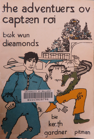 Federation University Historical Collection
Book, The adventuers ov captaen roi, 1962
Mary Egan who died on April 4th, 1981, spent 23 years as a greatly-respected lecturer in English curriculum at the Ballarat Teachers College, State College of Victoria and Ballarat College of Advanced Education. Basically white soft covered children's book using Pitman's Initial Reading AlphabetBook Plate, University of Ballarat Library sticker inside front cover and barcode on front cover, shelving sticker on back cover. University of Ballarat Stamp on inside cover.mary egan, ballarat teachers college, state college of victoria, ballarat college of advanced education, education department victoria, keeth gardener, iezac pitman, pitmans initial teaching alphabet -
 Eltham District Historical Society Inc
Photograph - Digital Photograph, Alan King, Downing-Le Gallienne house, Yarra Braes Road, Eltham, 30 January 2008
The property is a classic example of what made Eltham famous from the late 1940s to the 1960s. Covered under Heritage Overlay, Nillumbik Planning Scheme. Published: Nillumbik Now and Then / Marguerite Marshall 2008; photographs Alan King with Marguerite Marshall.; p149 The first view of the large double-storey house at Yarra Braes Road, Eltham South, is of a jutting roofline over a balcony, reminiscent of a large sailing vessel or galleon – very appropriate, considering the name of one of the first owners, Le Gallienne. The Downing-Le Gallienne property is a classic example of what made Eltham famous from the late 1940s to the 1960s and attracted so many artists and intellectuals to the area. Set in a largely indigenous bush-style garden, the mud-brick and timber house was built by Alistair Knox. It was built for economist Richard Downing, to become a founder of the welfare state in Australia and Chairman of the Australian Broadcasting Commission, and musician and composer Dorian Le Gallienne. Le Gallienne was a pioneering composer of modern music in Victoria before 1945, whose works included the Symphony in E.1 He wrote several pieces of film music for Eltham Films, including The Prize, working with its writer and artistic director Tim Burstall. Le Gallienne was also a music critic for The Argus and later for The Age. In 1967 the music critic Roger Covell argued that Le Gallienne’s Symphony, was ‘still the most accomplished and purposive . . . written by an Australian’. According to Alan Marshall the main inspiration behind the building that evolved from 1948 to 1964 was Le Gallienne. ‘He was able to see value in the simplest things and many who worked there had their eyes opened for the first time to the Eltham environment, to the bush and the trees and the fauna which lived there.’ The garden included no formality, no lawns, nor exotic plants. ‘Natural informal growth came right up to their doors and so did the indigenous birdlife.’ This informal style – consisting of mass and void – was to be developed and popularised by landscaper Gordon Ford from the 1950s. The large mud-brick and timber house, which was built in four stages and has three separate but linked sections, began as a small weekend retreat for the couple. In 1948, Downing and Le Gallienne (Dick and Dor to their friends), asked Knox to build the 36 x18 foot (11mx5.4m) building with a pitched slate roof. It was built on a concrete slab and included a fireplace, which is still in use. The second wing was built in 1954 after Downing had returned from working at the International Labour Office and the couple decided to live there full-time. The third section was built after the death of Le Gallienne in 1963, aged 48. He is buried in the Eltham Cemetery. When Downing married widow, Jean Norman (nee McGregor) and had to accommodate a large family, including her six children and one of their own, the last stage was built by 1964. At that time the house was considered one of the largest mud-brick houses in Victoria. It consists of five living areas, including a small ballroom. Several artists helped Knox build the Downing-Le Gallienne house, which was one of his first of mud-brick. They included painter Clifton Pugh, artist John Howley and actor Wynn Roberts. Ellis Stones had landscaped the first wing and Gordon Ford set the boulder steps and made a pool as part of the landscaping he completed. Inside, the mud-bricks are largely whitewashed with pine-lined ceilings and Oregon beams. A winding timber staircase in the front extends behind a glass window from the ground floor to the top. The property, of a little more than 0.5 ha, is bordered by Parks Victoria land, which extends to the Yarra River.This collection of almost 130 photos about places and people within the Shire of Nillumbik, an urban and rural municipality in Melbourne's north, contributes to an understanding of the history of the Shire. Published in 2008 immediately prior to the Black Saturday bushfires of February 7, 2009, it documents sites that were impacted, and in some cases destroyed by the fires. It includes photographs taken especially for the publication, creating a unique time capsule representing the Shire in the early 21st century. It remains the most recent comprehenesive publication devoted to the Shire's history connecting local residents to the past. nillumbik now and then (marshall-king) collection, dorian le gallienne, downing-le gallienne house, eltham, mudbrick construction, mudbrick houses, richard downing, yarra braes road -
University of Melbourne, Burnley Campus Archives
Newspaper - Newspaper Cutting, South Bourke Standard, The Horticultural Gardens, 25.07.1862
history, burnley gardens, mr phillips, curator, gardener, description of gardens -
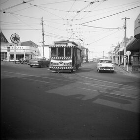 Ballarat Tramway Museum
Photograph - Set of four black and white negatives of Ballarat trams, Warren Doubleday, 20-4-1968
Photos 25-4-69, of: .1 - Ballarat 17 at Stones Corner with Caltex Service Station in the background. Tram leaving Main Road before joining Bridge St. .2 - No. 28 running from Bridge Street into Sturt Street with a "Trotting at Bray Raceway Tonight" Auxillary board. Tram has the destination of Gardens via Sturt St West. In the background are the Big W and the Dickins Store. .3 - Tram 43 on "0" road at the SEC Ballarat Depot. .4 - Tram 13 at the Gardens Loop in Wendouree Parade. Tram has an ANA Hospital and Medical Benefits (Australian Natives Association) Advertising Board.Yields information about the operation of the Ballarat tramway system that was operated by the State Electricity Commission of Victoria.Set of four black and white negatives of Ballarat Tramways, 120 size. ballarat, trams, tramways, sturt street, tram 17, main road, bridge street, tram 28, bray raceway, dickins, big w, tram 13, ana health, wendouree parade, gardens loop, depot, tram 43, stones corner, caltex -
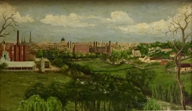 Kew Historical Society Inc
Painting - Panoramic View of Kew and Abbotsford from the garden of Rockingham, V Maloney, 1952
The extensive formal landscaped gardens of Rockingham had been created in the 1860s, and by the 1950s remained bordered to the south by the Barkers Road cutting, and to the north by Blytheswood, the neighbouring Syme family property, By 1940, the Syme family were no longer the occupiers of Rockingham. John Herbert Syme had died in October 1939, and by August the following year, his wife had made the house and garden available, rent free to the Red Cross as a convalescent home for Australian soldiers injured in the Second World War. At the time, the house was described as containing twenty rooms, including a ballroom and a billiards room, with a garden of eight acres overlooking the Yarra. The task of renovating the house to conform to its new function as a convalescent home took a year, finally opening in August 1941. Community support for Rockingham was widespread and included the decision by the National Gallery of Victoria to loan pictures from its collection to decorate the walls. Calls were made for women around Victoria to donate fruit and vegetables from their gardens, which the railways agreed to freight for free. Other local support included the work by a team of boys to establish a three-acre vegetable garden within the formal terraced gardens. From the beginning, occupational therapy formed a key component of the rehabilitation of psychologically injured soldiers. This is confirmed by contemporary newspaper accounts of weaving, ironwork, leatherwork, basketry and gardening by patients. Numerous photographs, held by the Australian War Memorial (AWM) and the State Library of Victoria (SLV), record the importance of these rehabilitation activities. The painting of the view across the river to Abbotsford may have been painted in one of these occupational therapy sessions. For many decades it hung in the occupational therapy room. It must have been on view following the sale of Rockingham by the Syme family to the Red Cross in 1955, and subsequently, until the house was demolished and its grounds finally subdivided in 1977.View of Abbotsford from the garden of Rockingham (1952) was created by V Maloney. The vantage point of the artist was the garden of Rockingham, one of two mansions overlooking the Yarra owned by the Syme family. The artwork depicts a number of sites - especially factories - that have since been demolished.Signed by the artist, lower right "V Maloney"rockingham red cross convalescent home, hospitals - kew (vic), rosemary lade, art therapy -
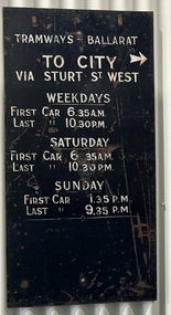 Ballarat Tramway Museum
Sign - Timetable Board - Gardens Loop via Sturt St West, State Electricity Commission of Victoria (SECV), 1960's
Timetable board giving first and last trams, weekdays, Sat and Sun. To 'City' with mounting holes, lettered on one side only, reverse side painted black, located at Gardens Loop, via Sturt St. sign. Some over painting on sign of former service times. See SECV Timetables. Demonstrates a SECV timetable signs that were located at various points on the tram system,Sheet metal sign, black background, white letters, painted.ballarat trams, timetable boards, secv street furniture -
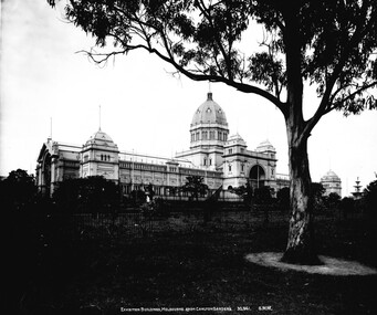 Melbourne Tram Museum
Photograph - Black & White Photograph/s, State Library of Victoria, c1900
Black and White Photograph of the Melbourne Exhibition Buildings from Carlton Gardens, c1900. Has caption "Exhibition buildings, Melbourne from Carlton Gardens 30,941. 6WW"trams, tramways, exhibition buildings, carlton gardens -
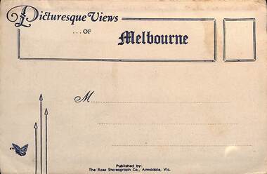 Melbourne Tram Museum
Postcard - Folder, Rose Stereograph Co, "Picturesque Views of Melbourne", mid 1930s
Comprises 12 photos of Melbourne, mid to late 1930s. Produced by Rose Stereograph of Armadale. 1 - Botanical Gardens and Government House Melbourne. - 2 - The MacRobertson Fountain Melbourne - Both the Fountain and the Shrine of Remembrance were completed in 1934. Government House tower features in the background. Also note the absence of any mature trees. See reference - completed 1934. 3 - Flinders Street Railway Station with a "W" class tram in Flinders Street and "Y" class tram in Swanston Street in the view 4 - St Kilda Road Melbourne - Looking south with the Queen Victoria Gardens in the left of the photo. 5 - Collins Street Melbourne - Showing the Regent Theatre, Manchester Unity Building and the Town Hall. 6 - Princes Bridge and city Skyline Melbourne - Shows; Princes Bridge, Yarra River, Excursion Ferry, Princes Walk, Flinders Street Railway Station, the Nicholas and Manchester Unity Buildings in Swanston Street and the Sargood Gardner building in Flinders Street. 7 - The Conservatory, Fitzroy Gardens Melbourne - 8 - The Cathedral Corner Melbourne - shows; Young & Jacksons Hotel, St Paul's Cathedral, The Gas & Fuel building, Ball & Walsh Department store and The State Theatre plus several "w" class trams in Swanston Street. 9 - St Kilda Road Melbourne - Looking south from Nolan Street. Note trees still present at the entrance area to the Shrine of Remembrance. 10 - Looking across Princes Bridge to St Kilda Road Melbourne - Looking south from the roof of the Nicolas Building showing; Princes Bridge, St. Kilda Road, The Shrine of Remembrance and the Victoria Barracks in the distance. 11 - Parliament House Melbourne - in Spring Street 12 - Captain Cook's Cottage, Fitzroy Gardens Melbourne - Erected in the gardens in 1934. Yields information about Melbourne city views and new attractions mid 1930s. Paper envelope folder with 6 photos on each side of a foldout section titled "Picturesque Views of Melbourne" melbourne, photo folders, postcards -
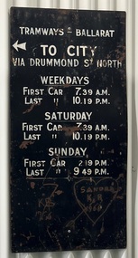 Ballarat Tramway Museum
Sign - Timetable Board - Gardens Loop - via Drummond St Nth, State Electricity Commission of Victoria (SECV), c1960's
Timetable board, giving first and last trams to City for weekdays, Sat and Sun. With mounting holes, lettered on one side only. Reverse side painted black. Was located at Gardens Loop, via Drummond St. Nth. See SECV TimetablesDemonstrates a SECV timetable signs that were located at various points on the tram system,Sheet metal sign, black background, with white letters, painted.Scratching on sign -= "KB 1966" and "Sandra / KB / 1966" contained within a heart.ballarat trams, timetable boards, secv street furniture -
 Lakes Entrance Historical Society
Photograph - Historic House, 2000
Building was residence of State School teacher from 1890's. Typical of Education Department residence for teacher. During 1990's cladding and window frames were altered.Colour photograph of a timber dwelling with high pitched gable roof. Gablet ventilator in centre of roof. Narrow front veranda. Pretty garden beds enclosed with railway sleepers. Situated at 14 Bulmer Street, Lakes Entrance Victoriahouses, fences, heritage study -
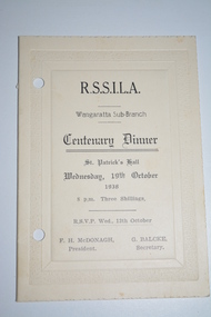 Wangaratta RSL Sub Branch
Card - Dinner Card, RSSILA Wangaratta Sub Branch Centenary Dinner
RSSILA Wangaratta Sub Branch Dinner held to celebrate the Centenary of Wangaratta in 1938. Dinner guests included the Chief Commissioner of Police and Mr Holland, State President. Other Centenary events included the unveilling of the King George V Memorial Gardens which were opened by Mr McEwan Minister of the Interior, representing the Prime Minister. John McEwen was born on 29 March 1900 at Chiltern in Victoria, to pharmacist David McEwen and Amy (Porter) McEwen. His mother died after the birth of their second child in 1901, and his father died in 1907. McEwen and his younger sister were raised by their grandmother, Ellen Porter, who ran a boarding house. They lived first at Wangaratta and then moved to Dandenong in 1912. In June and July 1965 he was acting Prime Minister.Dinner held by Wangaratta Sub Branch to celebrate the Centenary of Wangaratta in 1938. Cream parchment card with embossed borderR.S.S.I.L.A. Wangaratta Sub Branch Centenary Dinner St Patrick's Hall Wednesday 19th October 1938 8pm Three Shillings RSVP Wed., 12th October F.H. McDonagh President. G. Balcke, Secretary.rssila wangaratta sub branch, centenary dinner 1938, wangaratta centenary -
University of Melbourne, Burnley Campus Archives
Album - Black and white and sepia prints, Gardens Other Than Burnley, 1890-1920
... -'Civilizing the city: a history of Melbourne's public gardens,' State...-'Civilizing the city: a history of Melbourne's public gardens,' State ...Identification and information on reverse of some photographs given by Georgina Whitehead (Tel-9572 1225) who visited the Archives on 26 September, 1995 when she was writing a book on the various gardens owned and run by the Melbourne City Council-'Civilizing the city: a history of Melbourne's public gardens,' State Library of Victoria, Melbourne 1997.34 bkack and white and sepia photographs. Possibly used for Magic Lantern slides. Fitzroy Gardens: (1) Possibly, towards St Patrick's Cathedral. (2, 3) Path through avenue of trees. (4) Winter. Heavily pruned Elms. (5) Looking towards Clarendon St-eastwards. (6) Probably, lawn. (7) 2 copies, possibly Kiosk. (8) 1920's or earlier. Man sitting on bench. (9) Path through avenue of trees. (10) 2 copies. Probably-fenced originally-fences coming down 1890's on. (11) Statue at crossroad. (12) The Vase Fountain. (13) Tree trunks. (14) Tree trunks. (15) Probably, tree trunks. (16) Winding path. (17) Probably, misty winter scene. (18) Probably, summer. (19) Probably, this is the sort of garden seat used. (20) Avenue of trees, information about exposure on reverse. (21) 2 copies. Probably. Treasury Gardens: (22) Japanese Garden. (23)Japanese Garden. This area around the Lake done by Guilfoyle c.1901-1902. This photograph about this period. (24) Gardener at lake edge. Snowdon Gardens: (25) View towards city. Unidentified: (26) ?Botanic fern Gully/ Fitzroy Fern Gully. (27) Lake view. (28) Narrow path through long grass and trees. (29) Trees in winter. (30, 30a) Tree ferns. (31,32) Cordylines. (33) People on lawn. (34) Winter view of path through elms. These photographs have been scanned but have not been uploaded.georgina whitehead, fitzroy gardens, trees, elms, the vase fountain, trunks, treasury gardens, japanese garden, guilfoyle, snowdon gardens, fern gully, lake view, parks -
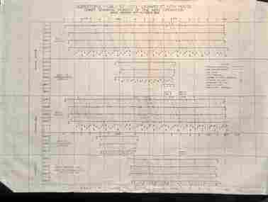 Ballarat Tramway Museum
Administrative record - Set of 4 Ballarat - Passenger graphs, State Electricity Commission of Victoria (SECV), 1952 - 1953
Set of 4 charts or graphs showing route, date, passenger numbers by time: 1 - Chart showing periods of one man operations - Sebastopol - Grey St - City - Lydiard St North - Oct. 1952 - Weekdays, Saturdays and Sundays 2 - Mt Pleasant - City - Gardens route for one week in Jan. 1953 3 - Sebastopol - City - Lydiard St route with intermediate cars to Grey St for one week in Jan. 1953 4 - Victoria St - City - Gardens route for one week in Jan. 1953.Demonstrates the SECV Ballarat office work to understand passenger numbers during 1952 and 1953.Printed graphs or charts on drawing print paper and marked with colour pens or inkSome have faded pencil notes on the rear.tramways, statistics, passenger services, reports, ballarat -
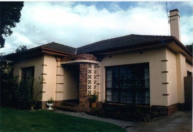 Glen Eira Historical Society
Photograph, Beauville Avenue, 16, Murrumbeena, 2001
Originally labelled "Beauville Estate, Established 1936, Still Thriving 65 years on, 10th March 2001", the Beauville Estate Album contains colour photographs of houses in the Estate. They were taken around the time of the Beauville Estate’s 65th Heritage Celebration held on 10/03/2001 and donated to the Caulfield Historical Society shortly afterwards. Photographer Bev Baxter. See also 2104A-19 which seems to be same property but with different colour and different larger plants in the right garden bed.City of Glen Eira’s Heritage Management Plan Vol 2 p79 (this is p84 of the pdf version) – HO12 Beauville Estate and environs, Murrumbeena: The Beauville Historic Area is important at the State level as the first large housing estate undertaken by the AV Jennings Construction Co, later Jennings Group Limited, Victoria’s largest home builder. It is important also as a very early estate development incorporating a range of features other than houses and including made roads, shops and recreation facilities. In this respect it was the forerunner of the comprehensively planned housing estate of the post war era. The estate is distinguished by its aesthetic values, as is the earlier and comparable Hillcrest Estate, which are formed by a combination of restrained diversity in house styles, with the exception of no. 30 in the emerging International style, and by a landscaped garden environment. Colour photograph of light brown coloured rendered house with unpainted brick features. Other features include a curved wall porch, tiled roof, and concrete driveway and path leading to the front porch. murrumbeena, houses, beauville avenue, architectural styles, 1930's, inter war style, a.v. jennings, av jennings, jennings, brick houses, beauville estate, porches, sir albert victor jennings, a v jennings construction co, beauville estate heritage area, glen eira city council, architectural features, jennings group limited, land subdivision, gardens, beauville historic area, brick features, chimneys -
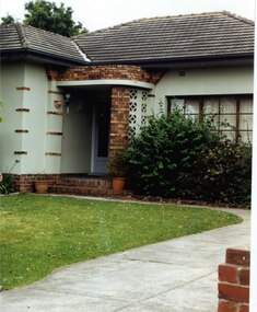 Glen Eira Historical Society
Photograph, Beauville Avenue, 16, Murrumbeena, 2001
Originally labelled "Beauville Estate, Established 1936, Still Thriving 65 years on, 10th March 2001", the Beauville Estate Album contains colour photographs of houses in the Estate. They were taken around the time of the Beauville Estate’s 65th Heritage Celebration held on 10/03/2001 and donated to the Caulfield Historical Society shortly afterwards. Photographer Bev Baxter. See also 2104A-18 which seems to be same property but with different colour and different smaller plants in the garden bed.City of Glen Eira’s Heritage Management Plan Vol 2 p79 (this is p84 of the pdf version) – HO12 Beauville Estate and environs, Murrumbeena: The Beauville Historic Area is important at the State level as the first large housing estate undertaken by the AV Jennings Construction Co, later Jennings Group Limited, Victoria’s largest home builder. It is important also as a very early estate development incorporating a range of features other than houses and including made roads, shops and recreation facilities. In this respect it was the forerunner of the comprehensively planned housing estate of the post war era. The estate is distinguished by its aesthetic values, as is the earlier and comparable Hillcrest Estate, which are formed by a combination of restrained diversity in house styles, with the exception of no. 30 in the emerging International style, and by a landscaped garden environment. Colour photograph of light green rendered house with unpainted variegated brown brick features. Other features include a curved porch, tiled roof and concrete driveway and path to the porch.murrumbeena, houses, beauville avenue, architectural styles, 1930's, inter war style, a.v. jennings, av jennings, jennings, brick houses, beauville estate, porches, sir albert victor jennings, a v jennings construction co, beauville estate heritage area, glen eira city council, architectural features, jennings group limited, land subdivision, gardens, beauville historic area, brick features, chimneys