Showing 654 items
matching water into gold
-
 Villa Alba Museum
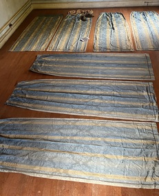
Decorative object - Suite of seven curtain panels, 1850s-90s
The curtains are significant for their comparative rarity of survival, and at the same time, are highly representative of opulent colonial taste in interior decor in the boom period. The curtain panels are of high quality materials and in unusually good condition, indicating they were used in a window with relatively little sunlight shining on them. They can be imagined in a grand room with one or more matching dressed windows.7 curtain panels, all the same size, possibly to fit a 3-light bay window; or alternately, to fit 3 windows in the same room (or something else altogether, if this is not the original total number of panels). Fabric: silk-wool mix, sky blue ground with narrow vertical gold stripes. The fabric is a damask weave with a watered (moiré) finish; the large, woven motif depicts an urn filled with stylised flowers, leaves and curlicues; the spacing of the motifs is more 19thC than older styles using much the same motif. Each curtain drop is decorated with an applied band of narrow, colour-matched gimp braid around the sides and lower end. The bottom hems are weighted with what feels like lead shot. The curtains are lined with sturdy brown cotton. They are gathered at the top edge on drawstring tape; and hand-sewn with small metal hanging rings. Faded vertical bands of sun exposure are visible on most of the curtains, and one panel has a mended tear on a lower side. Otherwise they are in excellent, sound condition.interior decoration-19th century, curtains-19th century, colonial taste-victoria, gold boom melbourne -
 Stawell Historical Society Inc
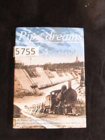
Book, Rhona van Veldhuisen, Pipe Dreams, A stroll through the history of water supply in the Wimmera Mallee, 2001
A History of Domestic and Stock Water supply in the Wimmera Mallee from 1836 to 1997Blue Hard Cover with Gold Print. Dust Jacket. Blue sky with clouds above b/W/ dam wall under construction, steam Train in foregound Pipe dreams A stroll through the history of water supply in the Wimmera Mallee. By Rhonda van Veldhuisen based on records researched by Bob McIIvenastawell water supply -
 Glenelg Shire Council Cultural Collection
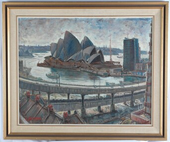
Painting, Newton Hedstrom, Opera House, n.d
CEMA Art Collection Noted that this work was sent by Caltex in exchange for the winner of the 1973 Caltex Prize, which was part of the Portland Art Society Art Prize. The exchanged work was a print by Greg Moncrieff. Included in the 1999 "Salvage" Exhibition at CEMA Arts Centre.The painting depicts the Sydney Opera House in shades of blue, brown and grey. In the foreground to the left is the brown roof of a building with four red chimneys. In front of these two buildings is an elevated road. Separating the road from the Opera House is a body of water (Sydney Harbour) completed in shades of cream and white. The shadow of the Opera House on the water's surface is completed in shades of blue and green. The work has a brown and gold frame with painted material mount and exposed canvas.Front: N. HEDSTROM (lower left, red paint) Back: (no inscriptions)sydney opera house, building, sydney harbour -
 Bendigo Historical Society Inc.
Document - Phillip's Water Wheel, Diamond Hill, Bendigo, 1876
'Messrs. George Phillips and Richard Williams erected a water wheel crushing machine near the site of the Old Albert shaft at Diamond Hill'. ( Bendigo Advertiser 4th June, 1890). The lack of water available for the venture from the water race caused much controversy in the following years. There was only enough water available in July 1890, to allow the company to operate three head of a ten head stamper. The site of the water wheel is still visible on the side of the water race at Diamond Hill. Mr. Geo Phillips held 1000 shares in the float of the Kangaroo Hydraulic Crushing & Gold Mining Company. He was one of the largest shareholders. (Victorian Government Gazette 72 Page 2260, 1893) Black and white photocopy. Image shows the Phillip's Water Wheel on Diamond Hill, Bendigo. Weatherboard building on right hand side of image, brick chimney on side of building. Large water wheel in cutting directly alongside building. Two men standing in between water wheel and building, one man standing on landing of waterwheel.mining, sandhurst, phillip's hydraulic waterwheel, stafford gold mine, diamond hill, george phillips, richard williams -
 Bendigo Historical Society Inc.
Document - Phillip's Water Wheel, Diamond Hill, Bendigo, 1876
'Messrs. George Phillips and Richard Williams erected a water wheel crushing machine near the site of the Old Albert shaft at Diamond Hill'. ( Bendigo Advertiser 4th June, 1890). The lack of water available for the venture from the water race caused much controversy in the following years. There was only enough water available in July 1890, to allow the company to operate three head of a ten head stamper. The site of the water wheel is still visible on the side of the water race at Diamond Hill. Mr. Geo Phillips held 1000 shares in the float of the Kangaroo Hydraulic Crushing & Gold Mining Company. He was one of the largest shareholders. (Victorian Government Gazette 72 Page 2260, 1893) Black and white photocopy. Image shows the Phillip's Water Wheel on Diamond Hill, Bendigo, date unknown but must be in 1890's. Three men and a dog standing in front of a weatherboard shed, brick chimney on side. Large water wheel on left hand side of image. Three images, 2008, showing former site of water wheel on channel, after heavy rain in district caused dry channel to run. mining, sandhurst, phillip's hydraulic waterwheel, stafford gold mine, diamond hill, george phillips, richard williams -
 Glenelg Shire Council Cultural Collection
Painting, Alan Wilson, Crumpets, 1991
Exhibition, CEMA 1991.View of beach with Crumpets Beach, Portland in foreground. Hills and cliffs in background. Scene sweeps up to the right of image. Sea is breaking over several boulders along shoreline. Far out to sea the water's colour is dark green and indigo, around a rocky island. Sky is pale blue with violet clouds near horizon line and white wispy clouds above. There are seagulls on the beach. Mounted in a double matt (white on violet) and framed under glass in decorative wooden frame with gold decoration and paint.Front: (no inscriptions) Back: Alan Wilson. "Crumpets". Hollands framing sticker (lower centre). Oils-on canvas on ply. 1991. (lower right) (pen) 1991 (lower centre) (pencil).portland, crumpets beach, seascape, portland beach -
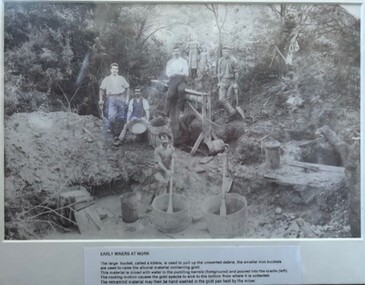 Greensborough Historical Society
Photograph - Photograph (Framed), Early miners at work, 1850s
Early miners at work caption reads: "The large bucket, called kibble, is used to pull up the unwanted debris, the smaller iron buckets are used to raise the alluvial material containing gold. This material is mixed with water in the puddling barrells (foreground) and poured into the cradle (left). The rocking motion causes the gold specks to sink to the bottom from where it is collected. The remaining material may then be hand washed in the gold pan held by the miner." This photograph possibly taken at Diamond Creek.From the John Davidson collection.Photograph in black plastic frame with typed caption on matte.john davidson, diamond creek, gold miners, mines and mining -
Stawell Historical Society Inc
Photograph, Aerial Photos of Stawell from a Hot Air Balloon 1992 -- 12 Photos
... . Gold Reef Mall looking West 8. Church Street looking West 9.... Stawell Gold Mine Evaporations Dams, Stawell Water Reservoirs ...Series of 12 Aerial Photos of Stawell. Hot Air Balloon, October 1992 1. Cnr. Maude St & Grant Street 2. Maude St Napier Street & Railway cutting 3. Trotting Track 4. Roundabout Wimmera & Sloane Street 5. Florence Street towards Cato Lake & Park 6. Grampians Range with Lake Lonsdale near center 7. Gold Reef Mall looking West 8. Church Street looking West 9. Looking towards Black Range 10. Moonie Dams Darlington Road Leisure Complex 11. Stawell Gold Mine Evaporations Dams, Stawell Water Reservoirs, Moonie Dams 12. Darlington Road looking towards Black RangeSeries of 12 colour photographs from the Air.stawell -
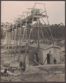
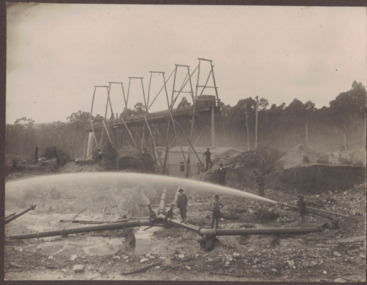
 Bendigo Historical Society Inc.
Photograph - BLACK AND WHITE PHOTOGRAPH OF THE NORTH DEBORAH MINE
North Deborah Mine in Eve Street, Bendigo, operated between 1937 and 1954. In that time it produced 128,000 ounces of gold.Black and white photograph of the North Deborah Mine, showing the poppet head, mullock heap to the left, man at the end of railway at the first level, does not show cables from the engine house to the wheels on top of the poppet, water tank at the side of the engine house, farm style corner of a fence at left of photo, small shed housing a pump for water, right foreground is a dam for water waiting to be converted to steam to operate the cable winder.mining, surface equipment, north deborah mine -
 Bendigo Historical Society Inc.
Painting - PAINTING OF THE OLD CORPORATE HIGH SCHOOL BENDIGO IN ROSALIND PARK
Water colour painting of The Old Corporate High SCHOOL Bendigo in Rosalind Park, by Alice Hands, framed in ornate gold frame with Burgundy mount NOTE ON REAR OF FRAME -'The old Continuation School or First Bendigo High School in Rosalind Park / gift of Miss Robshaw R.H.S.V.Alice Handsdomestic equipment, ornaments, art, the old corporate high school bendigo in rosalind park alice hands -ref mp 245 / -'the old continuation school or first bendigo high school in rosalind park / miss robshaw r.h.s.v. -
 Eltham District Historical Society Inc
Photograph - Digital Photograph, Marguerite Marshall, One Tree Hill Mine, Smiths Gully, 8 June 2006
Gold was discovered on One Tree Hill in 1854. The site has been worked intermittently until fairly recent times. Published: Nillumbik Now and Then / Marguerite Marshall 2008; photographs Alan King with Marguerite Marshall.; p53 Though still a working mine, One Tree Hill Mine at Smiths Gully, now stands in a tranquil reserve surrounded by bush and native animals - in contrast to its heyday. In the mid 19th century, when the mine was part of the Caledonia Goldfields, hundreds of men in search of their fortune worked the alluvial gold in the Yarra River, its tributaries and the reefs that made up the goldfields. Miner Stan Bone, assisted by Wilfred Haywood, is the last of the independent gold miners in the area and still uses the quartz crushing battery as miners did when gold was first discovered in the area in 1851.1 Stan, who is the last of six generations of miners in his family, was aged 17 when he began mining on his father Alex’ mine, The Golden Crown in Yarrambat. These days, after blasting the gold-bearing rock in Mystery Reef, one of the four reefs at One Tree Hill, Stan transports it around five kilometres by tip truck to the Black Cameron Mine for crushing. There he uses water from the waterlogged mine, (which still contains gold), as the Happy Valley Creek at One Tree Hill is usually dry.2 The One Tree Hill Mine has been worked for close to a century since it opened around the late 1850s.3 The Swedish Reef was its most productive reef and one of the largest in the area. Around 1859, extractions included 204 ounces (5.8kg) of gold, won from 57 pounds (26kg) of stone.4 Then during World War Two, Stan’s uncle, Bill Wallace, and Alex Bone, closed the mine. In 1973, Stan, with his Uncle Bill, reopened the Black Cameron Mine and worked there until 1988. Stan resumed mining One Tree Hill in 1998. As late as the 1920s gold was picked up by chance! When crossing a gully on his way to vote at the St Andrews Primary School, Bill Joyce picked up some quartz containing gold. This site was to become the Black Cameron Mine. The Caledonia Diggings, named after Scotland’s ancient name by local Scots, began around Market Square (now Smiths Gully) and included Queenstown (St Andrews), Kingstown (Panton Hill) and Diamond Creek. There were also poorer bearing fields in Kangaroo Ground and Swipers Gully (now Research). * None of these compared in riches to the Ballarat and Bendigo fields5, but the Caledonia Diggings continued intermittently for close to 100 years. Gold was discovered in Victoria following a bid to stem the disappearance of much needed workmen to the New South Wales diggings. Several businessmen offered a reward of £200, for the discovery of gold within 200 miles (322 km) of Melbourne. Late in June 1851, gold was first discovered at Andersons Creek, Warrandyte. Then in 1854, George Boston and two other men discovered gold at Smiths Gully. Gold transformed the quiet districts, with a constant flow of families and vehicles on the dirt tracks en route to the Caledonia Diggings. Three thousand people worked the gullies in Market Square, including about 1000 Chinese miners. The square established its own police, mining warden, gold battery, school, shops and cemetery and grog flowed. Market Square flourished until the middle 1860s. Bullocks transported quartz from the Caledonia Goldfields to the crushing machinery at the Queenstown/St Andrews Battery, near Smiths Gully Cemetery. It was destroyed by bushfire in 1962. By the late 1850s, most early alluvial fields were in decline, but minor rushes continued until around 1900 and some until the early 1940s. Some miners did well, although most earned little from their hard labour in the harsh and primitive conditions.6 But according to historian, Mick Woiwod, the gold fields helped to democratise society, as individuals from all walks of life were forced to share experiences, and the ability to succeed, depended less on inherited wealth or social rank.This collection of almost 130 photos about places and people within the Shire of Nillumbik, an urban and rural municipality in Melbourne's north, contributes to an understanding of the history of the Shire. Published in 2008 immediately prior to the Black Saturday bushfires of February 7, 2009, it documents sites that were impacted, and in some cases destroyed by the fires. It includes photographs taken especially for the publication, creating a unique time capsule representing the Shire in the early 21st century. It remains the most recent comprehenesive publication devoted to the Shire's history connecting local residents to the past. nillumbik now and then (marshall-king) collection, gold mining, one tree hill mine, smiths gully -
 Eltham District Historical Society Inc
Photograph - Digital Photograph, Marguerite Marshall, Smith Dam, Karingal Drive, Eltham, 19 September 2006
The dam at the entrance to the Nerreman Gateway in Eltham was built according to an internationally acclaimed theory developed by the builder's father. In 1920, Victorian engineer B.A. Smith was awarded the American Society of Civil Engineers J. James R. Cross Gold Medal for his Technical Paper titled 'Arched Dams'. It was the first time this medal had been awarded outside the United States. The concrete arched dam across the Eltham West Drain was built in 1940 by B.A. Smith's son and engineer, D. B. (Bernie) Smith to water the 24 acre (9.75 ha) hobby farm owned by himself and new wife, Isa Smith. Upon completion of the dam a pump-house was constructed beside the creek but before the water could be pumped up the hill they had to dig a trench and lay 500m of 100mm water main to an elevated holding tank. The Smiths made the pump-house their home for several years until they constructed their home at the top of the hill overlooking Eltham and views extending to Kinglake. Following Bernie's death in 1983, Nerreman Park was subdivided between 1993 and 1995. Gordon Ford designed the landscaping and the pump-house was demolished. Covered under Heritage Overlay, Nillumbik Planning Scheme. Published: Nillumbik Now and Then / Marguerite Marshall 2008; photographs Alan King with Marguerite Marshall.; p137 The dam at the entrance to the Nerreman Gateway in Eltham, was built according to an internationally acclaimed theory developed by the builder’s father. In 1920, Victorian engineer B A Smith was awarded the American Society of Civil Engineers J. James R. Croes Gold Medal, for his Technical Paper titled Arched Dams. It was the first time this medal had been awarded outside America. An international example of the application of Smith’s work can be found in the design of the Hoover Dam on the Colorado River, Nevada, USA. Built between 1930 and 1936, it is recognised by the ASCE as one of ‘America’s Seven Modern Civil Engineering Wonders’.1 The concrete arched dam across the Eltham West Drain was built by B A Smith’s son and engineer, D B (Bernie) Smith. Bernie’s dam followed his father’s theory, having a curvature that takes maximum advantage of concrete’s great strength in compression. The water load is carried into the abutments because of this curvature, which permits a wall thickness of only 225 millimetres thick at its crest, despite the dam’s capacity of more than 4.5 megalitres. The Eltham dam was designed to water the 24 acre (9.75 ha) hobby farm belonging to newly married couple Bernie and Isa Smith. Bernie, from Armadale, and Isa, from a farm at Tyntynder near Swan Hill, were attracted to the hilly topography and the creek running through the property. It extended from Ryans Road, Eltham, to Karingal Drive, Montmorency and was adjacent to Meruka Park. The Smiths named it Nerreman Park using the Aboriginal word Nerreman meaning ‘River Bend’ as their creek had a pronounced bend.2 In 1940 the first thing Bernie did was to build a dam, and with Isa’s help, a pump-house, to secure a water supply for their cattle, pigs, chickens, orchard and vegetable gardens. It was also available for the fire-plugs, which they placed all over the property in case of bushfire. The couple built the pump-house beside the creek and installed a Tange three-plunger pump, which had originally supplied the City of Wodonga with water. But before the Smiths could pump water up the hill from the dam they had to dig a trench and lay about 550 yards (500m) of a four-inch (100mm) water main up to an elevated holding tank. The trench was dug with a single furrow plough drawn by an old draught horse. Living in rough conditions did not deter the Smiths, who made the pump-house their home, where they still lived when their first child was born in 1944. They later built their home at the top of their property overlooking Eltham, with magnificent views to Kinglake, the Dandenong Ranges and Melbourne. From 1946 it took them almost 20 years to complete the 36-square house with its 12-foot (3.6m) high ceilings. Material for the concrete roof and walls faced with sandstone, was ripped out of the ground on their property by plough pulled by tandem Clydesdale horses. Isa was a strong woman – two days before their second child was born – she set three huge sandstone boulders in place in the bottom wall of the garage. She also mixed all the cement for the house. A collapsed kitchen wall did not discourage her from rebuilding it in a week, while her husband was away working in the country. She later recalled: ‘We stood back to admire this beautiful wall we’d built and while we were looking at it, it came tumbling down’.3 Following Bernie’s death in 1983, Nerreman Park was subdivided, between 1993 and 1995. Local Gordon Ford designed the landscaping and the pump-house was pulled down. But the dam remains as a reminder of exceptional engineering4 – and of a remarkable couple.This collection of almost 130 photos about places and people within the Shire of Nillumbik, an urban and rural municipality in Melbourne's north, contributes to an understanding of the history of the Shire. Published in 2008 immediately prior to the Black Saturday bushfires of February 7, 2009, it documents sites that were impacted, and in some cases destroyed by the fires. It includes photographs taken especially for the publication, creating a unique time capsule representing the Shire in the early 21st century. It remains the most recent comprehenesive publication devoted to the Shire's history connecting local residents to the past. nillumbik now and then (marshall-king) collection, eltham, karingal drive, smiths dam, bernie smith, gordon ford, isa smith, nerreman gateway, nerreman park estate, dams -
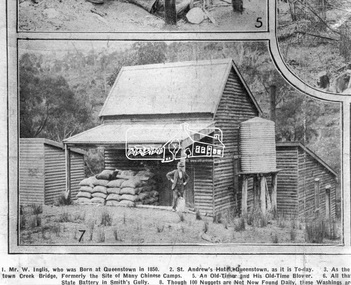 Eltham District Historical Society Inc
Photograph, Queenstown - St. Andrews District. "Quartz awaiting crushing at the State Battery in Smith's Gully.", c.1929
"The State Battery was the central component in the gold mining of this area from the 1920s. The battery crushed the gold bearing quartz extracted from the mines and was a sizeable weatherboard building enclosing the engine and stampers. All that now remains are the bases for the machinery that comprised the battery, one timber and a couple of concrete bases and the nearby dam, which supplied water. However the historic significance of the site remains and is enhanced by the Queenstown Cemetery on the other side of Smiths Gully Road". - Bick Study 1922 This site is now the Peter Franke Reserve and is managed by Parks Victoria Photo Source: The Leader, Nov. 2nd, 1929This photo forms part of a collection of photographs gathered by the Shire of Eltham for their centenary project book,"Pioneers and Painters: 100 years of the Shire of Eltham" by Alan Marshall (1971). The collection of over 500 images is held in partnership between Eltham District Historical Society and Yarra Plenty Regional Library (Eltham Library) and is now formally known as the 'The Shire of Eltham Pioneers Photograph Collection.' It is significant in being the first community sourced collection representing the places and people of the Shire's first one hundred years.Digital imagesepp, shire of eltham pioneers photograph collection, queenstown, st andrews, gold mining, smiths gully -
 Glenelg Shire Council Cultural Collection
Painting, Whalers Point from Harbour Trust Dock, n.d
Port of Portland CollectionView of harbour and jetties from a dock. Dock is in foreground. A white fishing vessel is berthed at a jetty positioned near the dock. In background is a view of the foreshore with buildings. The water is pale blue with darker blue details. The sky is blue with grey wash depicting clouds near horizon line. Mounted in thick cream canvas mount, framed under glass in wooden gold painted frame.Front: Signature - Ramon Horsfield (lower left) (orange paint). Back: (no inscription)port of portland -
 Bendigo Historical Society Inc.
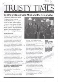
Document - CENTRAL DEBORAH GOLD MINE: TRUSTY TIMES, RISING WATER
... CENTRAL DEBORAH GOLD MINE: TRUSTY TIMES, RISING WATER... by the Central Deborah Gold Mine with rising ground water and its impact... by the Central Deborah Gold Mine with rising ground water and its impact ...BHS CollectionThree page stapled document titled 'Trusty Times' Issue 90, Special Edition July 2012, outlining the issues faced by the Central Deborah Gold Mine with rising ground water and its impact across the broader Bendigo mining area if a solution to the problem is not found. Photo on front of 'Trusty Times' shows Damian Drum, Tom Seddon, Peter Walsh and Jeff Rigby. Images on page 3 show the pumping equipment already installed.bendigo, mining, central deborah gold mine -
 Linton and District Historical Society Inc
Photograph, Electro Hydraulic Dredge, Snake Valley, 1909
... for getting gold. The streams of water under high pressure just.... These dredges were used for getting gold. The streams of water under ...Electro hydraulic dredge Snake Valley 1909. J Mc Bennett, was an engineer back at the main base, at Dawson's dam on the Carngham Road, Between Linton and Snake Valley. These dredges were used for getting gold. The streams of water under high pressure just washed the hills and ground away. This dredge closed down early 1910. 200 H.P. motors were used and 10 in. pumps.Black and white image of three workmen, one beside mining building the other two at dredge pump outlet. Image mounted on dark brown card. Between 1904 and 1911 the Electro Hydraulic Company sought to extract gold in an area north of Linton known as the Hard Hills. By blasting water from high-pressure hoses into the hillsides, soil containing gold was washed out for sluicing. Two gravel pumps in Dawson's Dam pumped the wash through the sluices. Despite considerable investment in expensive equipment, the Company did not have a great deal of success, and the mining operation ceased in 1911.mining, gold, mining equipment, electro hydraulic dredge, dredging, sluicing, dawson's dam, snake valley, miners -
 Linton and District Historical Society Inc
Photograph, Electro Hydraulic Dredge, Snake Valley, 1909
... . These dredges were used for getting gold. The streams of water under... for getting gold. The streams of water under high pressure just washed ...Black and white image of workmen at electro hydraulic dredge Snake Valley mine site. Image has been mounted on dark brown card. Electro hydraulic dredge Snake Valley Victoria 1909. J.M.C. Bennett was an engineer back at the main base, at Dawson's Dam on the Carngham Road, bet Linton and Snake Valley. These dredges were used for getting gold. The streams of water under high pressure just washed the hills and ground away. This dredge closed down early 1910. 200 H.P. Motors were used and 10 in. pumps.electro hydraulic dredge, dredging, sluicing, mining, gold, miners, mining equipment, snake valley -
Bendigo Historical Society Inc.
Document - MINING REPORTS - ANNUAL REPORT, SEC. FOR MINES & WATER SUPPLY 1904
... Annual Report Sec for Mines & Water Supply 1904 Gold Yield Value ...BHS CollectionHandwritten notes from the Annual Report, Sec. for Mines & Water Supply for the Year 1904. Report mentions gold yield for the District of Bendigo and the Total for Victoria, quantity of ore treated, Value of gold per ounce for 1904 for Australian States, Yield of Gold for Bendigo Goldfield, the deep mines, winze in the New Chum Rly and Victoria Quartz, and the number of men employed in alluvial and quartz mining (gold) during 1904.document, gold, mining reports, mining reports, annual report sec for mines & water supply 1904, gold yield, value of gold, deep mines, new chum railway, lazarus new chum, victoria quartz, north johnsons, lansells 180, shenandoah, new chum & victoria, new chum consolidated, gt extended hustlers, eureka extended, princess dagmar -
 Bendigo Historical Society Inc.
Slide - HORWOOD COLLECTION - WATTLE GULLY, c1965
Wattle Gully, at Chewton was first worked in 1853 albeit initially only to a depth of 10 metres. An exploratory drilling in 1934, that deflected off course, discovered new rich gold seams and by 1937 large amounts of gold were being extracted. The mine closed in 1969 because high water levels and the low price of gold made it unprofitable at the time. It has operated intermittently since then.Horwood Collection - Wattle Gully. Wattle Gully Mine, Chewton. Much of the buildings and other structures still remain. Markings Wattle Gully Chewton. DEC65MKodakmine, gold, walltle gully, horwood collection - wattle gully. wattle gully mine, chewton. much of the buildings and other structures still remain -
 Glenelg Shire Council Cultural Collection
Painting, James McLear, Untitled (Lake), 1990
Scene depicting a lake in the foreground with trees behind. The trees are reflected in the water. Top third of the image depicts a deep blue sky, highlighted in some areas with white. Mounted in cream matt, framed under glass in wooden frame with gold edging.Front: McL 90 (lower right) (white paint) Back: (no inscriptions)landscape -
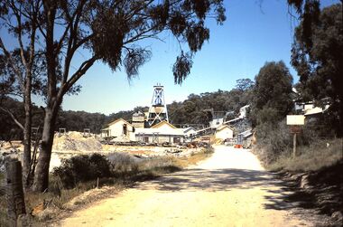
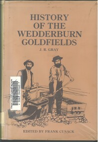 Bendigo Historical Society Inc.
Book - HISTORY OF THE WEDDERBURN GOLDFIELDS, 1888
Gold was first discovered in 1852 on what was then named Korong or Mt Korong goldfields. It was soon found that the area was not suitable for alluvial mining because of a lack of water but quartz mining was more successful. The township of Wedderburn was surveyed 1856/57. The first public crushing works was established in 1859.Hardcover book with printed dust jacket and plastic cover. 92 pages with black and white illustrations, fold out map and index. Covers the history of the Wedderburn Goldfields and the discovery of gold generally in Australia from the 1850s until c1880s. Written by Joshua R Gray and edited by Frank Cusack.Joshua R Gray and Frank Cusack.gold, goldfields, goldfield -
 Glenelg Shire Council Cultural Collection
Painting, A S Murray, Dunrobin, n.d
CEMA Art Collection Previously located in History HouseA large body of water with a shore line in the foreground on the left. Depicted in shades of grey, the calm water features a patch of white in the centre - reflection. In the background to the right, is a distant view of a small patch of land covered in trees. Behind the land is an out of focus view of mountains in the distance. The top half of the work features a grey cloudy sky. The work has a gilded ornate frame with cardboard and gold mounts and glass.Front: A.S. Murray Label attached to glass front: Presented to Council in 1984 by A.S. Murray Dunrobin Back: W. Hamer 189 Sturt Street Ballarat VICTORIA BUILDINGS, OPPOSITE CITY FIRE BRIGADElandscape -
 Forests Commission Retired Personnel Association (FCRPA)
Beechworth FCV District office sign
This sign proudly hung outside the Forests Commission Victoria (FCV) Beechworth office which is now site of the Forestry Heritage Museum. The granite building in the Beechworth's historic precinct was once the Gold Warden's Office and is one of the town's original buildings. The FCV was the main government authority responsible for management and protection of State forests in Victoria between 1918 and 1983. The Commission was responsible for ″forest policy, prevention and suppression of bushfires, issuing leases and licences, planting and thinning of forests, the development of plantations, reforestation, nurseries, forestry education, the development of commercial timber harvesting and marketing of produce, building and maintaining forest roads, provision of recreation facilities, protection of water, soils and wildlife, forest research and making recommendations on the acquisition or alienation of land for forest purposes″. The Forests Commission had a long and proud history of innovation and of managing Victoria's State forests but in September 1983 lost its discrete identity when it was merged into the newly formed Victorian Department of Conservation, Forests and Lands (CFL) along with the Crown Lands and Survey Department, National Park Service, Soil Conservation Authority and Fisheries and Wildlife Service. After the amalgamation the management of State forests and the forestry profession continued but the tempo of change accelerated, with many more departmental restructures occurring over the subsequent four decades. Responsibilities are currently split between the Department of Energy, Environment and Climate Action (DEECA), Forests Fire Management Victoria (FFMV), Parks Victoria, Melbourne Water, Alpine Resorts Commission, the State Government-owned commercial entity VicForests and the privately owned Hancock Victorian Plantations (HVP).Large office sign. Hand painted in traditional FCV mission brown and gold colour scheme.forests commission victoria (fcv), forest signs -
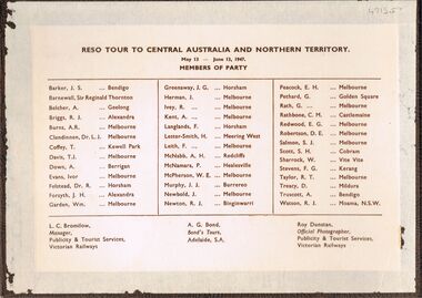 Bendigo Historical Society Inc.
Photograph - PETHARD COLLECTION: PHOTOGRAPH RESO TOUR
George Pethard Collection including references to Taraxale Brewing Company Pty brown covered 29x19mm photographic album bound with gold string / 52 black and white Photographs of Reso tour to central Australia and Northern Territory / includes Aboriginal camps , camel trains / landscapes , war cemetery at Adelaide River / May 13- June 13 1947 / the 40 members of the party are also named includes: George Pethard / Aboriginal camp , Jay Creek consisting of makeshift tents / crowd playing 'Two Up ' Photo of the ship 'Meggs' at Darwin / Manton Dam - Darwin's water supply photo. Reso Tour to Central Australia and Northern Territory.Roy Dunstan Publicity and Tourist services Victoria Railwaysphotograph, person, male, george pethard / taraxale brewing company pty ltd / aboriginal camps / camel trains / war cemetary at adelaide river photo of the ship 'meggs' at darwin / manton dam - darwin's water supply photo -
 Glenelg Shire Council Cultural Collection
Painting, A.S. Murray, Scene on the River Murray, n.d
Art collection Previously located in History HouseThe painting depicts a large body of water surrounded by tree-covered riverbank. Depicted in shades of blue and grey, the water features patches of brown and blue which illustrate the reflections of riverbank trees. In the foreground to the left of the water is a large tree which extends up to cover the top left skyline of the work. Featured in the background is a dense patch of trees completed in shades of blue. To the right of the water is a dense patch of trees completed in shades of brown and black. These trees reach into a purple and blue cloud-filled sky. The work has a gilded ornate frame with cardboard and gold mount and exposed canvas.Front: A.S. Murray Plaque attached to frame: SCENE on the RIVER MURRAY Back: (no inscriptions) -
 Glenelg Shire Council Cultural Collection
Drawing - Drawing, botanical, Collin Elwyn Woolcock, Cotula coronopifolia (Water Buttons). Podolepis jaceoides (Showy Podolepis), 1985
Part of "Woolcock Gallery Collection" exhibition 1989 CEMADrawings of cuttings and flower details of two plant species with yellow flowers and green foliage. Five drawings including one flower detail (yellow and pencil), one cutting of tall yellow (Daisy-like) flower with a red-brown stem and long green leaves along stem and at base, one cutting with many flowers (no petals, button-like) on thin green stems with green flower details. The work is on white paper mounted on apricot (first layer) and pale grey (second layer) cardboard. It is framed under glass in a gold and grey-green frame.Front: CEW/85 (vertical next to stem) Podolepis jaceoides (Showy Podolepis) Cotula coronopifolia (Water Buttons) (lower left) CEWoolcock (lower right) Back: 22 (upper left)woolcock, cema, botanical -
 Federation University Historical Collection
Booklet, University of Ballarat, Research@YourUB, 2007 -2010
Research@YourUB is a newsletter highlighting research at the University of Ballarat.1) Spring 2009 .2) Spring 2007 - Rob Wallis, green packaging, mould, food safety, Zhaohao Sun, Widcorp, Jesica Block, Arts Academy anniversary, Dorothy Wickham, Dora Pearce, Loris Button, SmartGreen, Marilyn Davidson, Overcoming bullying in schools, overweight patients. .3) Autumn 2009 - Australian Security Laboratory to fight cybercrime, brewing better beer, John Yearwood, Centre do Informatics and Applied Optimizaton, John Smyth, Angela Murphy? Willows by the water. Patrice Braun, Laura Kostanski, preventing injuries, why should we research art. .4) October 2009 - Future Research Directions .5) January 2009 - Research themes, Wayne Robinson, John yearwood, Andrew Stranieri, Peter Gell, Julian Lowe, John Smyth, John McDonald, Caroline Finch, Dennis Else, Informatics and Applied Optimization, Regional Futures, Disadvantage and Inequality in Education and Health, Injury Prevention and Safety Promotion. .6) Spring 2010 - Frank Stagnitti, Brad Mitchell, Diane Clingin, Robyn Brandenburg, Amanda McGraw-Pleban, Charlynn Miller, Fadi Charchar, Robert Hodder, Amber Stabek, ACSL maps, Murray Darling Basin, Peter Gell, John Smyth, Kate Brass, gaming machines, John McDonald, Helen Aucote, Andrew Cooper, Deborah greeenslade, Dara twomey, Andrew Warnock, synthetic grass, .7) Autumn 2006 - Wayne Robinson, toenail research, Dora Pearce, biodiversity in modified lansdscapes, Centre for Informatics and Applied Optomization (CIAO), John Yearwood, Lawrie Angus, Barry Golding, Georgina Tsolidis, John Smyth, Maxine Cooper, Mary Hollick, Emil Milos, Jeff Woodger, Michelle Ziccolo, Rosemary Green, Raelene Gregory, Julian Lowe, Jessie Harman, Debora Campbell, John McDonald, Denise Corboy, Catherine Knox, Henry Lawson, Meg Tasker, Warren Young, Amanda Telford.university of ballarat, wallis, wickham, wayne robinson, toenail research, dora pearce, biodiversity in modified landscapes, centre for informatics and applied optimization, john yearwood, lawrie angus, barry golding, georgina tsolidis -
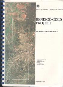 Bendigo Historical Society Inc.
Booklet - Kangaroo Flat Gold Mine Collection: Western Mining Corporation Bendigo Gold Project Environmental Effects Statement December 1987, Western Mining Corporation, Bendigo Office, Western Mining Corporation Limited Bendigo Gold Project Environment Effect Statement December 1987, December 1987
Spiral bound booklet, plastic cover, black plastic binding, On front cover: Western Mining Corporation Bendigo Gold Project, Environment Effects Statement, December 1987. On front page, colour aerial photograph of Bendigo mining areas mentioned in report. Key on front page related to photograph: 1. Woodvale Evaporation Ponds. 2. New Moon area. 3. North New Chum Williams United shaft. 4. Carshalton, Carshalton shaft. 5. South Nell Gwynne, North Bendigo shaft. Contents: historical perspective; Western Mining Corporation Ltd Bendigo activities; project outline, project approvals - controlling factors, elements of the mining project, surface based exploration, underground operations and surface support, mining areas and operations ore and mullock haulage, New Moon area, water management, environmental management. Planning and land use, socio-economic environment, physical environment and biological environment are examined and discussed. bendigo, goldmining, bendigo mining nl, bendigo goldfield, environmental effects statement, bendigo gold project, woodvale evaporation ponds, new moon, north new chum, carshalton, south nell gwynne, western mining corporation -
 Bendigo Historical Society Inc.
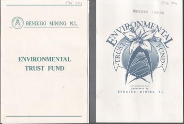
Booklet - Kangaroo Flat Gold Mine Collection: Environmental Trust Fund Policy booklet
The Bendigo Environmental Trust was established in 1995 with funds provided by Bendigo Mining NL. The Trust was administered by an honorary Board of Trustees. Preference was given to projects that reflected the philosophy of the Bendigo Region Conservation Strategy, namely flora and fauna, energy conservation, land and water protection and waste management. Two copies of an eight page booklet titled ' Environmental Trust Fund, sponsored by Bendigo Mining NL. One booklet date stamped 4 Sep 2002. Content identical in both: policy; how the Bendigo ining Environmental Trust works; who can apply; areas supported; how to apply; preferred format; limitations of grants; support period; when to apply, where to apply and project documentation required.Date stamp September 2005 on one copy.bendigo mining nl, environment, environmental trust, flora and fauna, energy conservation, waste management, land and water protection, kangaroo flat, goldmining -
 Bendigo Historical Society Inc.
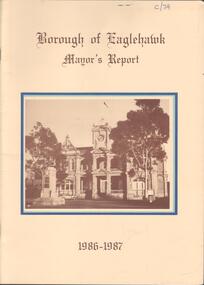
Booklet - Kangaroo Flat Gold Mine Collection: Borough of Eaglehawk Mayor's Report 1986-87, 1986-1987
Twenty page Mayor's Report, Borough of Eaglehawk, 1986-1987. Yellow cover, brown text, centre front sepia image of the Town Hall, Eaglehawk. Inside front cover, letter attached from Borough Of Eaglehawk to the Secretary of Bendigo Mining Corp., Victoria Street, Eaglehawk: attention is drawn 'to page 14 of the Report which covers the resurgence of gold mining activity in the Borough' Page 14 describes Western Mining Corporation's prospecting of the 1000 old mines in the Eaglehawk area to discover how much gold is left. 'The first new headframe seen in Central Victoria for 50 years has just been erected at the site of the Wlliams United mine in Eaglehawk' The company is pumping out 10 million litres of water a day to uncover the old workings' The Mayor of 1986-1987 Cr W. Carney, first woman Councillor (1977) and first woman Mayor for Eaglehawk ((1986-87).bendigo mining nl, goldfield, goldmining, production, eaglehawk borough, mayor of eaglehawk, cr. carney, williams united