Showing 22700 items
matching yarra
-
 Greensborough Historical Society
Map, Melbourne and Metropolitan Board of Works. Survey Division, MMBW, Yarra 2500 / 17.26. Hurstbridge, 1978_01
Melbourne and Metropolitan Board of Works. Yarra 2500 [base map] 17-26. Hurstbridge. Municipalities of Diamond Valley 257 and Eltham 238. Prominent streets include: Flat Rock Road and Heather Avenue. Includes Hurstbridge Railway Station.MMBW Map in 1:2500 [scale] series. Cream parchment with green tape reinforcing on edges and punched holes on left edge.mmbw, melbourne and metropolitan board of works, shire of diamond valley, hurstbridge - maps -
 Greensborough Historical Society
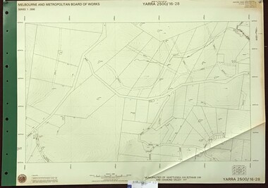
Map, Melbourne and Metropolitan Board of Works. Survey Division, MMBW, Yarra 2500 / 16.28. East of Hurstbridge, 1977_10
Melbourne and Metropolitan Board of Works. Yarra 2500 [base map] 16.28. East of Hurstbridge. Municipalities of Whittlesea 239, Eltham 238 and Diamond Valley 257. Prominent streets include: Boyds Road, Bannons Lane and Wattle Tree Road. MMBW Map in 1:2500 [scale] series. Cream parchment with green tape reinforcing on edges and punched holes on left edge.mmbw, melbourne and metropolitan board of works, shire of diamond valley -
 Greensborough Historical Society
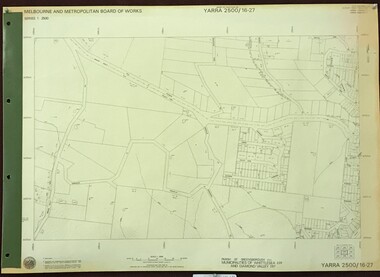
Map, Melbourne and Metropolitan Board of Works. Survey Division, MMBW, Yarra 2500 / 16.27. Hurstbridge, 1977_10
Melbourne and Metropolitan Board of Works. Yarra 2500 [base map] 16.27. Hurstbridge. Parish of Greensborough 2724. Municipalities of Whittlesea 239 and Diamond Valley 257. Prominent streets include: Haleys Gully Road, Kendalls Lane and Bingley Avenue. MMBW Map in 1:2500 [scale] series. Cream parchment with green tape reinforcing on edges and punched holes on left edge.mmbw, melbourne and metropolitan board of works, shire of diamond valley, shire of whittlesea, hurstbridge - maps -
 Greensborough Historical Society
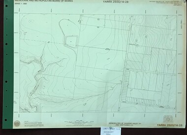
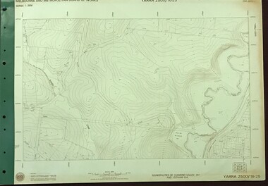
Map, Melbourne and Metropolitan Board of Works. Survey Division, MMBW, Yarra 2500 / 14.28. Yarrambat Park, 1977_09
Melbourne and Metropolitan Board of Works. Yarra 2500 [base map] 14.28. Yarrambat Park. Municipalities of Diamond Valley 257 and Whittlesea 239. Prominent streets include: Bannons Road and Yan Yean Road. Features include the Plenty River.MMBW Map in 1:2500 [scale] series. Cream parchment with green tape reinforcing on edges and punched holes on left edge.mmbw, melbourne and metropolitan board of works, shire of diamond valley, whttlesea, yarrambat - maps -
 Melbourne Tram Museum
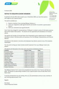
Document - Notice, Yarra Trams, "Notice to ESSuper Scheme Members", 4/01/2010 12:00:00 AM
Notice - A4 sheets, printed with Yarra Trams logos, titled "Notice to ESSuper Scheme Members", dated 4 Jan 2010 advising of three options in the job offer letter of November. 2009 with regard to their Superannuation. Gives details of the sessions at depots and actions to be taken. Singed by Des Davies Human Resources Director.trams, tramways, superannuation, yarra trams, employment, retirements -
 Melbourne Tram Museum
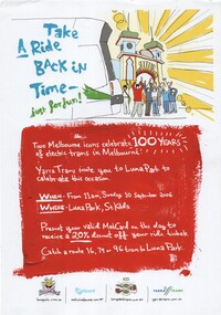
Poster, Yarra Trams, "Take a Ride back in time just for fun!", Aug. 2006
Poster - full colour on white paper, A4 single sided, titled "Take a Ride back in time just for fun!" Part of the centenary of electric trams, 10 September 2006 at Luna Park, gives discount for Metcard holds. Has logos for Luna Park, Metcard, Yarra Trams 100 years of trams.trams, tramways, metcard, yarra trams, 100 years of electric trams, luna park -
 Melbourne Tram Museum
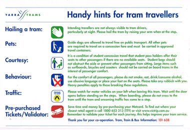
Sign - Adhesive label, Yarra Trams, "Handy hint for tram travellers", c2005
Adhesive labels for fitting to the inside of a tramcar advising passengers how to: hail trams; pets, courtesy; behaviour; traffic - watch for motor vehicles when leaving and asking passengers to pre purchase Metcards. Provides a web address for Victrip and telephone numbers. Has Yarra Trams logo in the top left hand corner.trams, tramways, yarra trams, passengers, behaviour, signs, tramcars -
 Melbourne Tram Museum
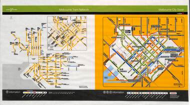
Poster, Yarra Trams, "Melbourne Tram Network", Nov. 2005
Full colour poster printed, A3 size, on laminated sheet - titled "Melbourne Tram Network. Shows a diagrammatic layout of the Melbourne tram system, shows zones (2 zones), CBD, tram terminuses including the City Saver boundary. Has the Yarra Trams and Metlink logos. Dated Effective November 2005trams, tramways, yarra trams, metlink, maps, metcard, tickets, city section -
 Melbourne Tram Museum
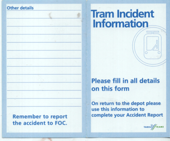
Document - form, Yarra Trams, "Tram incident information", c2005
Small wallet or pocket size form for recording details of an incident with a tram. Has Yarra trams logo on the front.Demonstrates an accident report form to record on site details of an incident.Form - blue print on white light card.tramways, forms, accidents, report, tramcars -
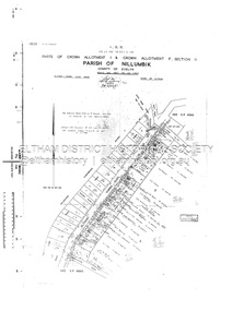
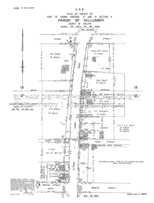 Eltham District Historical Society Inc
Document - Survey Plan, Country Roads Board, SP 6800, Eltham-Yarra Glen Road; Bridge St to Henry St, 1958
1958 C.R.B. Plan of Survey of Part of Crown Portions 12 and 13 Section 4 Parish of Nillumbik, County of Evelyn Eltham-Yarra Glen Road., Shire of Eltham Shows Surveyor field notes, property ownership and building type and construction.1958, a.m. gahan, a.s & s.j. davis, annie ellen davies, bridge street, country roads board, d.a. lyon, dave lyon, eltham, flora towell, g.e. gallagher, henry street, j. lyon, k. greene, main road, p.a. gahan, survey plan, w.l. chynoweth pty ltd, york street, neil webster collection -
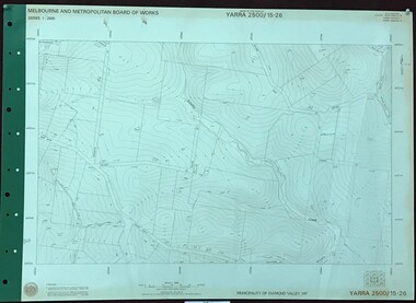 Greensborough Historical Society
Map, Melbourne and Metropolitan Board of Works. Survey Division, MMBW, Yarra 2500 / 15.26. Yarrambat, Hacketts Road, 1978_07
Melbourne and Metropolitan Board of Works. Yarra 2500 [base map] 15.26. Yarrambat, Hacketts Road. Municipality of Diamond Valley 257. Prominent streets include: Black Gully Road, Hacketts Road and Collins Lane. Features include Scrubby Creek.MMBW Map in 1:2500 [scale] series. Cream parchment with green tape reinforcing on edges and punched holes on left edge.mmbw, melbourne and metropolitan board of works, shire of diamond valley, yarrambat - maps -
 Eltham District Historical Society Inc
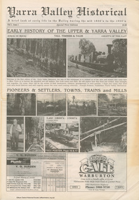
Work on paper (item) - Newspaper, Joseph Dubois, Yarra Valley Historical: a brief look at early life in the Valley during the mid 1800's to the 1900's
Volume 1, Issue 1. Early History of the Upper and Yarra Valley. "Welcome to the fist edition of the Yarra Valley historical, the aim of this newspaper is to remind us of the men and women who came here to mine, farm or harvest the plentiful and tall timbers, that built towns and cities..." Estimated date of publication 2010. The newspaper is full of potted histories of places with historical photographs, maps and timelines. Acknowledgment and citations for source material given. Advertisements for business's at the time of publicaion. Lilydale, De Castella family, p2. Mount Evelyn p6. Wandin [Anker family] p7. Seville [William Henry Smith; Mr and Mrs Thomas Payne; Duck family; Chandler family] p8. Woori Yallock p10. Yellingbo p11. Hoddles Creek p12. Launching Place p13. Yarra Junction p14. Reminiscences of Don 'Ripper' Reid p18. Wesburn p20. Warburton Village Settlement p22. Warburton p23. Big Pats Creek p26. McMahons Creek / Reefton [Brimbonga School] p27. Gladysdale / Gilderoy [Saxton family] p28. Powelltown p30.lilydale, mt evelyn, wandin, seville, woori yallock, yellingbo, hoddles creek, launching place, yarra junction, don reid, reminiscences, wesburn, warburton, big pats creek, mcmahons creek, reefton, gladysdale, gilderoy, powelltown, newspaper -
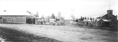 Yarra Glen & District Historical Society
Black and white photographs, Bell Street Yarra Glen looking north c.1900
View of Bell Street Yarra Glen looking north from junction with King Street. On left hand side is Scott & Allen's General Store, next to that is a bootmaker, then the house of Charles Bath, the Grand Hotel and the Colonial Bank building. On the eastern side of Bell Street (right hand side of photograph) is the Victoria Hall. Beyond that is W.J.Dawborn's General Store, then Smith's bakery, and on top of the hill the trees surrounding 'Point Pleasant' owned by the Herbert family.yarra glen, point pleasant, grand hotel, victoria hall, bell street, charles bath, general store, colonial bank, bank building, w j dawborn, scott and allen, bootmaker, smith, bakery, baker s shop, herbert -
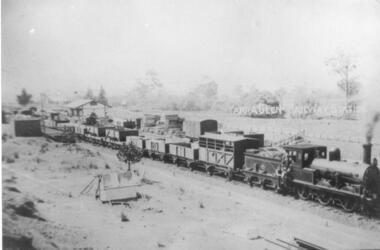 Yarra Glen & District Historical Society
Black and white photographs, Yarra Glen Railway Station
Black and white reproduction of a sepia postcard. Diagonally across the centre of the picture is a steam engine with goods train of mixed railway trucks. Three men are on the steam engine. The back end of the train is near the railway station platform. The goods shed is on the other side of the train. Beyond that are a post and rail fence and trees lining the Yarra River. In the foreground is small pitched tent. Other railway trucks and piles of timber and other goods are in the railway yard.yarra glen, post and rail fence, yarra glen railway station, railway station, goods shed, steam train, goods train, railway trucks, tent, pitched tent -
 Greensborough Historical Society
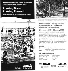
Leaflet, Looking Back, Looking Forward, 2019
Advertising leaflet for a display of historical photographs and paintings depicting "Summer fun in Yarra Plenty". The display ran from 05/12/2019 until 06/01/2020 at the Eltham Library Community Gallery and was organised by Yarra Plenty Heritage Group with paintings from the Nillumbik U3A Drawing and Painting Group. Greensborough Historical Society had 3 photographs in the display.1 page leaflet, black and white text and images. 2 copies.yarra plenty heritage group, yarra plenty regional library, nillumbik u3a -
 Eltham District Historical Society Inc
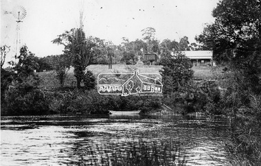
Negative - Photograph, ‘Worlingworth’, Yarra River, Eltham
‘Worlingworth’, Yarra River, Eltham Original homestead on the property ‘Worlingworth’, a large residence and surrounding farm site standing on a knoll above the River Yarra in Banoon Road, Eltham. The present house was built about 1922 and was originally owned by Mr A.R. Read, a stock and station agent and member of the Stock Exchange (who left the district in early 1926 to take up permanent residence at his Warburton property). It became the home of notable anthropologist Prof. Dr. Donald Thomson (1901-1971) and Mrs. Gladys Thomson who were married in 1925 and had twin sons in 1934 and is considered historically and aesthetically significant to the Shire of Nillumbik.This photo forms part of a collection of photographs gathered by the Shire of Eltham for their centenary project book, "Pioneers and Painters: 100 years of the Shire of Eltham" by Alan Marshall (1971). The collection of over 500 images is held in partnership between Eltham District Historical Society and Yarra Plenty Regional Library (Eltham Library) and is now formally known as 'The Shire of Eltham Pioneers Photograph Collection.' It is significant in being the first community sourced collection representing the places and people of the Shire's first one hundred years.Digital image 4 x 5 inch B&W Negshire of eltham pioneers photograph collection, a.r. read, banoon road, donald thomson, eltham, gladys thomson, worlingworth, yarra river -
 Mount Evelyn History Group
Book Railways of the Yarra Valley, Nick Anchen, Railways of the Yarra Valley, 2010
Railways of the Yarra Valley takes you on a nostalgic journey back in time to when the Victorian Railways branch lines and the ingenious bush tramways were the lifeblood of isolated rural communities. This book examines the much loved Warburton and Healesville railways, along with the fascinating Powelltown, Britannia Creek and Warburton tramway systems, all of which were instrumental in making the Yarra Valley Victoria�s most prosperous timber region. Featuring a superb array of colour and b&w images, most never before published, complimented by interesting and informative text, plus stories from those who saw and worked the lines. Soft bound, 96 pages. (from website)Coloured cover soft back book -
Mount Evelyn History Group
Book Railways of the Yarra Valley, Nick Anchen, Railways of the Yarra Valley, 2010
Railways of the Yarra Valley takes you on a nostalgic journey back in time to when the Victorian Railways branch lines and the ingenious bush tramways were the lifeblood of isolated rural communities. This book examines the much loved Warburton and Healesville railways, along with the fascinating Powelltown, Britannia Creek and Warburton tramway systems, all of which were instrumental in making the Yarra Valley Victoria�s most prosperous timber region. Featuring a superb array of colour and b&w images, most never before published, complimented by interesting and informative text, plus stories from those who saw and worked the lines. Soft bound, 96 pages. (from website)Coloured soft back book -
 Melbourne Tram Museum
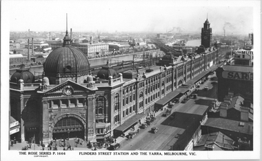
Postcard, Rose Stereograph Co, "Flinders Street Station and the Yarra, Melbourne", late 1920s
Rose Series postcard No. P 1666, titled "Flinders Street Station and the Yarra, Melbourne". This photo is looking southwest from St Paul's Cathedral over the station building along the Yarra river. The St Kilda/Port Melbourne and Queens bridge are in view, but not the Spencer St bridge which was built during the late 1920s. The AW Allen's Limited Confectionary Factory constructed in 1923-24 on Riverside Avenue dominates the landscape on the south side of the river directly behind the dome of the Flinders Street railways station. One very long set of horse-drawn carts can be seen alongside the center entrance to the railway station building in Flinders Street.Yields information about an aerial view of Melbourne late 1920sPostcard - printed real photograph with Rose Stereograph Co. name on the rear.tramways, trams, flinders st station, yarra river, bridges, railways, flinders st -
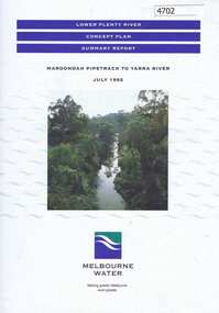 Greensborough Historical Society
Pamphlet, Lower Plenty River concept plan, summary report: Maroondah Pipetrack to Yarra River, 1992_07
This draft concept plan covers the lower Plenty River from the Maroondah Pipe track in Greensborough to where the Plenty meets the Yarra. Melbourne Water was the lead agency, assisted by the Shires of Eltham and Diamond Valley, City of Heidelberg, the EPA and Department of Planning and Housing.Coloured pamphlet, photograph and plans 12 pages. 2 copies.plenty river, maroondah aqueduct, melbourne water -
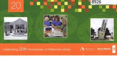 Greensborough Historical Society
Flyer - Invitation, Yarra Plenty Regional Library, Celebrating 20th anniversary of Watsonia Library, 08/11/2008
Watsonia Library is part of Yarra Plenty Rergional Library, operating over Banyule, Nillumbik and Whittlesea Local Government areasCardboard invitation, printed in colour both sidesAddressed to Rosie Bray in handwritingyarra plenty regional library, watsonia library -
 Melbourne Tram Museum
Pamphlet, Yarra Trams, "Did you know - No. 5", c2013
Pamphlet - Single DL special size sheet, printed both sides in full colour titled cut for a hanging on a tram handrail, titled "Did You know - No. 5", with an image of a rhino on a skateboard on the front and details that a full tram can weigh as much as 50 tonnes. c2013 - has the Yarra Trams 4 logo.trams, tramways, yarra trams, rhinos, advertisements, safety -
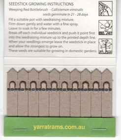 Melbourne Tram Museum
Functional object - Seedstick folder, Yarra Trams, "Trams for Trees", c2004
Folder made from light card, printed both sides, stapled along the bottom containing 10 seed sticks - of weeping red bottlebrush. Includes planting instructions. Titled "Trams for Trees" Has the Yarra Trams early 2000 logo and Love your trams logos printed. Item encouraged planting of trees.trams, tramways, souvenirs, yarra trams, environment, trees -
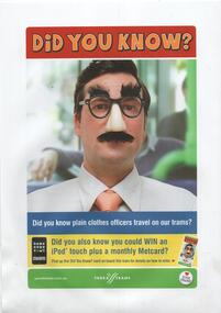 Melbourne Tram Museum
Poster, Yarra Trams, "Did you know", c2008
A4 photocopied sheet titled "Did You Know", featuring a person in disguise and advising that plain clothes officers travel on our trams. Date of publication unknown but circa 2008. Has Yarra trams, Love your Trams button badge and that you win a iPod touch and monthly Metcard. 2 copies held.trams, tramways, yarra trams, ticket inspectors, tickets -
 Eltham District Historical Society Inc
Document - Survey Plan, Country Roads Board, SP 6561, Eltham-Yarra Glen Road; Park Rd to Bellevue Rd, 1957
1957 C.R.B. Plan of Survey of Parts of Crown Allotment 1 & Crown Allotment F, Section II Parish of Nillumbik, County of Evelyn Eltham-Yarra Glen Road, Shire of Eltham Shows Surveyor field notes, property ownership and building type and construction.eltham-yarra glen road, country roads board, eltham, main road, survey plan, 1957, a.r. thomas, b. & b.d. hearn, b.g. anderson, bellevue road, e.m. pitts, f.a. m. macrae, g.e. & b. moulder, j. bromley, j.m. & s.g. johnstone, k.f. pitts, l.c. docksey, m. & e.c.w. baart, m.p. bromley, n.r. ord, p.j. & g.e. murphy, park road, r.a. bruce, r.a. macbeth, r.w. shearing, railway road, s.e. & y.p. houghton, w.k. bell, w.s.r. & f.n. toley, neil webster collection -
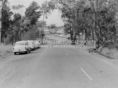 Eltham District Historical Society Inc
Photograph, Barry Philp, Eltham-Yarra Glen Road, Research, Vic, c.1967
View looking north along Eltham-Yarra Glen Road towards intersection with Research-Warrandyte Road and Research shops, c.1967. Three cars on the left, two FC Holden sedans (1958-1960) and a Holden HD Station Sedan (1965-1966)In digital metadata "My beautiful picture"cars, eltham-yarra glen road, holden fc, holden hd, main road, research (vic.), research shops, research-warrandyte road -
 Greensborough Historical Society
Map, Melbourne and Metropolitan Board of Works. Survey Division, MMBW, Yarra 2500 / 17.27. Central Hurstbridge, 1978_02
Melbourne and Metropolitan Board of Works. Yarra 2500 [base map] 17-27. Central Hurstbridge. Parish of Greensborough 2724, Municipalities of Diamond Valley 257, Eltham 238 and Whittlesea 239. Prominent streets include: Anzac Avenue and Hurstbridge-Arthurs Creek Road. MMBW Map in 1:2500 [scale] series. Cream parchment with green tape reinforcing on edges and punched holes on left edge.mmbw, melbourne and metropolitan board of works, shire of diamond valley, hurstbridge - maps -
 Greensborough Historical Society
Map, Melbourne and Metropolitan Board of Works. Survey Division, MMBW, Yarra 2500 / 16.25. Wattle Glen, 1978_07
Melbourne and Metropolitan Board of Works. Yarra 2500 [base map] 16-25. Wattle Glen. Municipalities of Diamond Valley 257 and Eltham 238. Prominent streets include: Nimmo Road, Broad Gully Road and Heidelberg-Kinglake Road. Includes Yulong Park.MMBW Map in 1:2500 [scale] series. Cream parchment with green tape reinforcing on edges and punched holes on left edge.mmbw, melbourne and metropolitan board of works, shire of diamond valley, wattle glen - maps -
 Greensborough Historical Society
Map, Melbourne and Metropolitan Board of Works. Survey Division, MMBW, Yarra 2500 / 13.26. Yarrambat, Worns Lane, 1978_02
Melbourne and Metropolitan Board of Works. Yarra 2500 [base map] 13.26. Yarrambat, Worns Lane. Municipalities of Diamond Valley 257 and Whittlesea 239. Prominent streets include: Worns Road, North Oatlands Road and Licola Street. Features include Plenty River.MMBW Map in 1:2500 [scale] series. Cream parchment with green tape reinforcing on edges and punched holes on left edge.mmbw, melbourne and metropolitan board of works, shire of diamond valley, whttlesea, yarrambat - maps -
 Greensborough Historical Society
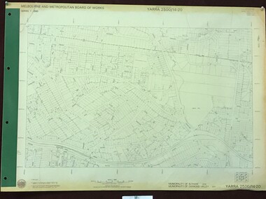
Map, Melbourne and Metropolitan Board of Works. Survey Division, MMBW, Yarra 2500 / 14.20. Montmorency, Sherbourne Road, 1977_06
Melbourne and Metropolitan Board of Works. Yarra 2500 [base map] 14.20. Montmorency, Sherbourne Road. Municipality of Diamond Valley 257 and Eltham 238. Prominent streets: Sherbourne Road, Karingal Drive and Calrossie Avenue. Features include Montmorency Station and Meruka Park.MMBW Map in 1:2500 [scale] series. Cream parchment with green tape reinforcing on edges and punched holes on left edge.mmbw, melbourne and metropolitan board of works, shire of diamond valley, montmorency - maps