Showing 10395 items
matching plan
-
 Bendigo Historical Society Inc.
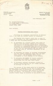
Document - MERLE HALL COLLECTION: DOCUMENTS RELATING TO FEASIBILITY OF BENDIGO ARTS CENTRE 1970 TO1977
Various documents relating to feasibility of Bendigo Arts Centre 1970-1977 - Correspondence; various notes (some handwritten); large plan of Crestknit factory layout; information re Public Meeting 12/10/1976; Address to Bendigo City Council by Dr Westbrook 15/9/1975; Bendigo Arts Activity Centre - Draft Brief; Bendigo Arts Council Minutes (50th meeting held 6y/4/1976); Performing Arts Centre Study - Sub-Committee Meeting 6/9/1976; Public Notice in Bendigo Advertiser for a Proposed Community Arts Activity Centre (16/10/197?); Statement fro Bendigo Arts Council re a Performing Arts Centre for Bendigo - what the Council knows & what the Council recommends; letter from The Bendigo Trust 29th March 1976 with details of the proposed Convention Centre to be part of the Dai Gum San project on Danger Hill (the Trust believing that a Cultural Centre should be incorporated into the proposed Convention Centre) - attached are a site plan, building plans(convention hall, proposed ground floor theatre and two architectural elevations of the proposed convention centre, -
 Ringwood and District Historical Society
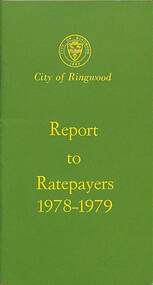
Booklet, City of Ringwood Report to Ratepayers 1978-1979, 1978
Green covered community information booklet for Ringwood residents covering Council Representatives' and Service Organisations' contact details, Council Finances, Immunizations, Major Works, Planning (Live Theatre/Functions Centre), Health and Community Services, Christmas Holiday Play Centres, Lord Mayor's Children's Camp, Rates, Municipal Elections, Dogs, Rubbish Tip, Overhanging Foliage, Vandalism, Building By-laws, Fred Dwerryhouse Swimming Centre, Planning (Commercial Centre), Netball Complex, Citizenship Ceremonies, Mini Bikes, School Crossing Supervision, Ringwood Garden Competition, and Coming Events (International Year of the Child, Family Fun Day, Highland Carnival). Includes two City of Ringwood Free Tipping Vouchers valid until the end of 1979.Mayor's Message - Cr. A.B. Henderson, J.P. Back cover - Green tinted photograph of Ringwood Memorial Tower captioned: Ringwood - "A Happening Community"rinx -
 Bendigo Historical Society Inc.
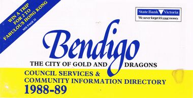
Book - BOOKLET: ''BENDIGO THE CITY OF GOLD AND DRAGONS'' (1988-89)
45 paged booklet - ''Bendigo - The City of Gold and Dragons'' (1988-89)- a Council services and community information directory. Contents : Mayor's message; City of Bendigo; Exciting current developments; Council meeting times; Your councillors; Corporate plan; Chief Executive Officer's message; Corporate Services Department; Rates and valuations; Revaluation; Tourism; Parking and traffic control; Dogs; By-laws; Community development; Library; Health and Human Services Department; Child Care centres; Home Care services; Leisure; Engineering and Technical Services Dept.; Town planning; Building; Parks and recreation; Shopping guide/car parking; Discount shopping vouchers; Operations Department; Street lighting; Garbage collection. Photographs of councillors and Departmental managers/directors.bendigo, council, community information directory, cr. r. adams, colin nankervis, michael currie, james douglass, phillip geri, rodney fyffe, jeffrey fyffe, peter morley, chris wilson. rates and valuations, parking, by laws, shopping. departmental managers and directors. -
 Bendigo Historical Society Inc.
Map - GREAT EXTENDED HUSTLER'S MINE - TRANSVERSE SECTION OF THE GREAT EXTENDED HUSTLER'S MINE
Transverse Section of the Great Extended Hustler's Mine on the Hustler's Line of Reef. Bulletin No 33, Plate No XII. Shows Poppet legs at the surface and Sill of Shaft at 788.99 feet above Sea Level, Cross Cuts and their depths, stone and geographical features encountered and their references and a number of enlarged drawing of sections of the cross cuts, Geological Survey of Victoria emblem and signed by H A Whitelaw, Underground Survey Office Bendigo, September 1913. The depths of crosscuts to No 21 were taken from plans of surveys by Mr Walker and Mr Craven, noted under Reference. Another note: This Saddle Reef is sketched from Mr Walker's plan. Dividends amounting to 360,000 pounds were obtained from it. This item has not been scanned or photographed.mining, parish map, great extended hustler's mine, transverse section of the great extended hustler's mine, old shaft, mr walker, mr craven, geological survey of victoria, underground survey office bendigo, h a whitelaw -
 Ballarat Tramway Museum
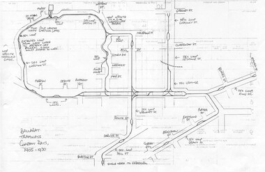
Document - Photocopy, Dave Macartney, Drawing of ESCo Ballarat Tramways, c1990
Photocopy of a drawing prepared by Dave Macartney in the mid 1980's of the track layout of the Electric Supply Co. of Victoria's Ballarat Tramway system, excluding the single track to Sebastopol. Plan shows the location of the loops, loop type, street names, position of replacement loops installed by the SEC during the reconstruction, depot layout, powerhouse siding and railway in Lydiard St. North. Prepared from inspecting the Plans of Ballarat services drawings in the Ballarat Water Board's Offices. Drawn on the back of old import forms of a light weight paper and has shown through the printing underneath. Titled "Ballarat Tramways Company Days 1905 - 1930" Number of small differences to the map drawn for Keith Kings, "The Ballarat Tramways" book, page 22.trams, tramways, ballarat, esco, track layout, map -
 Bendigo Historical Society Inc.
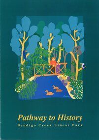
Pamphlet - MERLE HALL COLLECTION: ROSALIND PARK CREATIVE VILLAGE BENDIGO PROJECT PAMPHLET, 1993
MERLE HALL COLLECTION: ROSALIND PARK CREATIVE VILLAGE BENDIGO PROJECT PAMPHLET Pathway to History Bendigo Creek Linear Park Inside pages - Graphic image of the Linear Park from Alexandra Fountain to the Botanical Gardens, includes Rosalind Park, Golden Dragon Museum, Shamrock Hotel, Bendigo Gas Works, Chinese Joss House, Chinese Tea House, Lake Weroona, Wetlands, White Hill Cemetary and mine sites. On outside pages, cover, historical notes on Bendigo and Notes on the Bendigo Creek Linear Park. Notes on the back cover: A joint project of the City of Greater Bendigo and the Department of planning and development. Production by the Publick Affairs Branch, Department of Planning and Development. Printed in Bendigo June 1993 4360/93. -
 Kew Historical Society Inc
Photograph - Victorian Villa, High Street, c.1922
Subdivision plans are historically important documents used as evidence of the growth of suburbs in Australia. They frequently provide information about when the land was sold on which a built structure was subsequently constructed as well as evidence relating to surveyors and real estate and financial agents. The numerous subdivision plans in the Kew Historical Society's collection represent working documents, ranging from the initial sketches made in planning a subdivision to printed plans on which auctioneers or agents listed the prices for which individual lots were sold. In a number of cases, the reverse of a subdivision plan in the collection includes a photograph of a house that was also for sale by the agent. These photographs provide significant heritage information relating house design and decoration, fencing and household gardens.An old inscription on this photograph identifies it as ‘an elegant timber villa in High Street. It occupied part of Lot 91, bought by Edward Glyn in the land sale of 16th October 1851, and run as a flower farm’. The subdivision called the ‘Flower Farm Estate’ in East Kew occurred in 1922. [The subdivision plan is on the reverse of this photo.] The Estate included 61 lots on either side of Boorool Road between High Street and Harp Road. In the MMBW Detail Plan 2017 of 1926, a number of these new villas had already been built. Matching houses with MMBW maps can always be a challenge, however if this house was near the corner of Boorool Road and High Street, it seems to fit the profile of a house called ‘Maxton’ (demolished).Photographer's name on photograph, lower right, and stamp on mount lower right: "A. Aberline, Glenferrie".houses - maxton - high street - kew (vic.), violet farm estate, subdivisions - kew (vic.) -
 Melbourne Tram Museum
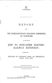
Document - Report, Victorian Parliament, "Report - The Parliamentary Standing Committee on the Proposed Kew to Doncaster Electric Railway Extension", Dec. 1930
Printed - 12 page foolscap, stapled on left hand side, 2 sections, Victorian State Parliamentary Report titled "Report - The Parliamentary Standing Committee on Railways on the Proposed Kew to Doncaster Electric Railway Extension", together with minutes of evidence, book of reference, plan and map, dated 4/12/1930. References a 1928 document, looks at construction costs, sites for railway stations, estimated revenue and expenditure, existing Kew line financials, town planning, bus services, MMTB input, tram services, alternatives, committee views, recommendations and a map of proposed routes, showing roads and tram services. Includes references to the Kodak estate and APM proposals at Fairfield. See Reg Item 2102.3 for the 1928 report.trams, tramways, doncaster, railways, public transport, kew -
 Melbourne Tram Museum
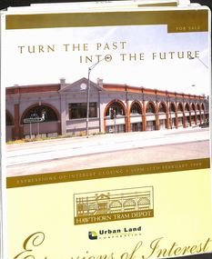
Document - Folder with papers, Urban Land corporation, "Hawthorn Tram Depot - Expressions of Interest Documentation", late 1998
White two spring clip folder with papers, titled "Hawthorn Tram Depot - Expressions of Interest Documentation", sub-titled "Turn the Past into the Future" Has a photo of Hawthorn Tram depot and an image on the front cover. Closing date 17/2/1999, prepared by the Urban Land Corporation with the assistance of VicTrack. Approx 110 pages with supplementary papers in the end covers. Contains a table of contents, checklist, EOI Process, Development Brief, Site conditions. Gives details of the heritage registration, site plans, building plans, property title and detailed room condition and use of the ground floor. Supplementary papers include the marketing brochure, letters and a detail feature and level survey by Bosco Johnson surveyors, 30-9-1998.trams, tramways, htt, hawthorn tram depot, sale of land, property -
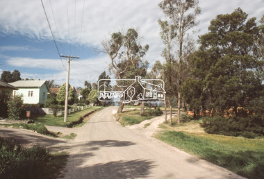
 Eltham District Historical Society Inc
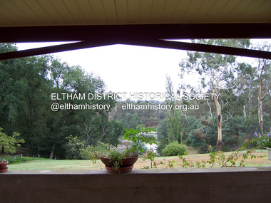
Photograph - Digital Photograph, Marguerite Marshall, 'Worlingworth', 10-26 Banoon Road, Eltham, 30 January 2006
'Worlingworth', Eltham, home of noted anthropologist the late Professor Donald Thomson and his wife Dorita Thomson. Covered under Heritage Overlay, Nillumbik Planning Scheme. Published: Nillumbik Now and Then / Marguerite Marshall 2008; photographs Alan King with Marguerite Marshall.; p127This collection of almost 130 photos about places and people within the Shire of Nillumbik, an urban and rural municipality in Melbourne's north, contributes to an understanding of the history of the Shire. Published in 2008 immediately prior to the Black Saturday bushfires of February 7, 2009, it documents sites that were impacted, and in some cases destroyed by the fires. It includes photographs taken especially for the publication, creating a unique time capsule representing the Shire in the early 21st century. It remains the most recent comprehenesive publication devoted to the Shire's history connecting local residents to the past. nillumbik now and then (marshall-king) collection, banoon road, donald thomson, dorita thomson, eltham, worlingworth -
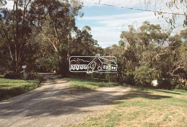
 Eltham District Historical Society Inc
Photograph - Digital Photograph, Marguerite Marshall, View of the Yarra River from 'Worlingworth', 10-26 Banoon Road, Eltham, 30 January 2006
'Worlingworth', Eltham, home of noted anthropologist the late Professor Donald Thomson and his wife Dorita Thomson. Covered under Heritage Overlay, Nillumbik Planning Scheme. Published: Nillumbik Now and Then / Marguerite Marshall 2008; photographs Alan King with Marguerite Marshall.; p127This collection of almost 130 photos about places and people within the Shire of Nillumbik, an urban and rural municipality in Melbourne's north, contributes to an understanding of the history of the Shire. Published in 2008 immediately prior to the Black Saturday bushfires of February 7, 2009, it documents sites that were impacted, and in some cases destroyed by the fires. It includes photographs taken especially for the publication, creating a unique time capsule representing the Shire in the early 21st century. It remains the most recent comprehenesive publication devoted to the Shire's history connecting local residents to the past. nillumbik now and then (marshall-king) collection, banoon road, donald thomson, dorita thomson, eltham, worlingworth -
 Eltham District Historical Society Inc
Document - Property Binder, 739 Main Road, Eltham
Letter 1 December 1994 from Harry Gilham to Russell Yeoman Eltham Shire Offices, re history of property: sold by Matthews family to Claire Fitzpatrick and husband, then sold to Shire of Eltham for Living and Learning Centre, 9 November 1994 sketch plan.main road, eltham, property, houses, shops, businesses, claire fitzpatrick, eltham living and learning centre -
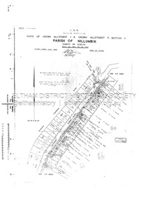 Eltham District Historical Society Inc
Document - Survey Plan, Country Roads Board, SP 6561, Eltham-Yarra Glen Road; Park Rd to Bellevue Rd, 1957
1957 C.R.B. Plan of Survey of Parts of Crown Allotment 1 & Crown Allotment F, Section II Parish of Nillumbik, County of Evelyn Eltham-Yarra Glen Road, Shire of Eltham Shows Surveyor field notes, property ownership and building type and construction.eltham-yarra glen road, country roads board, eltham, main road, survey plan, 1957, a.r. thomas, b. & b.d. hearn, b.g. anderson, bellevue road, e.m. pitts, f.a. m. macrae, g.e. & b. moulder, j. bromley, j.m. & s.g. johnstone, k.f. pitts, l.c. docksey, m. & e.c.w. baart, m.p. bromley, n.r. ord, p.j. & g.e. murphy, park road, r.a. bruce, r.a. macbeth, r.w. shearing, railway road, s.e. & y.p. houghton, w.k. bell, w.s.r. & f.n. toley, neil webster collection -
Glen Eira Historical Society
Document - Murrumbeena State School No. 3449
Submission to Caulfield Council for the construction of a Community Education Facility/Multi- Purpose Room for Murrumbeena State School Prepared for submission April, 1981, Rationale for costing of Community Education/ Multi- Purpose facility. Contains Street maps of area, Plans for proposed new structuremurrumbeena state school, hobart road murrumbeena, school, caulfield city council, school council, howard and munro architects., community education, facility, site plans, murrumbeena primary school council, education department. -
 Eltham District Historical Society Inc
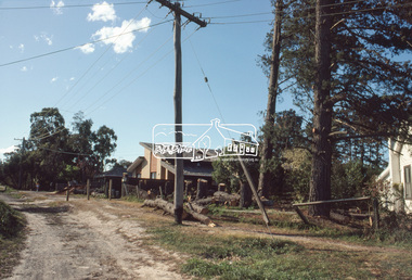
Slide, View looking northeast to turnabout near 10 McCarthy Grove, Montmorency, c.Oct. 1980
One of a series of images of roads and infrastructure taken by Eltham Shire Council Planning and Engineering officers. They provide perspective of the changes in housing styles and road development that began sweeping in from the mid 1970s with increasing urbanisation of what was once more outlying suburbs and regions.35 mm colour positive transparency Mount - Kodak Kodachrome CardProcessed Oct 1980houses, infrastructure, mccarthy grove, montmorency, roads -
 Eltham District Historical Society Inc
Slide, McCarthy Grove, Montmorency, extended driveway from Main Road, c.Oct. 1980
One of a series of images of roads and infrastructure taken by Eltham Shire Council Planning and Engineering officers. They provide perspective of the changes in housing styles and road development that began sweeping in from the mid 1970s with increasing urbanisation of what was once more outlying suburbs and regions.35 mm colour positive transparency Mount - Kodak Kodachrome CardProcessed Oct 1980houses, infrastructure, mccarthy grove, montmorency, roads -
 Eltham District Historical Society Inc
Slide, View looking southwest to turnabout near 9 McCarthy Grove, Montmorency, c.Oct. 1980
One of a series of images of roads and infrastructure taken by Eltham Shire Council Planning and Engineering officers. They provide perspective of the changes in housing styles and road development that began sweeping in from the mid 1970s with increasing urbanisation of what was once more outlying suburbs and regions.35 mm colour positive transparency Mount - Kodak Kodachrome CardProcessed Oct 1980houses, infrastructure, mccarthy grove, montmorency, roads -
 Eltham District Historical Society Inc
Slide, McCarthy Grove, Montmorency looking west near No. 27, c.Oct. 1980
One of a series of images of roads and infrastructure taken by Eltham Shire Council Planning and Engineering officers. They provide perspective of the changes in housing styles and road development that began sweeping in from the mid 1970s with increasing urbanisation of what was once more outlying suburbs and regions.35 mm colour positive transparency Mount - Kodak Kodachrome CardProcessed Oct 1980houses, infrastructure, mccarthy grove, montmorency, roads -
 Eltham District Historical Society Inc
Slide, McCarthy Grove, Montmorency looking east towards Reichelt Avenue, near no. 27, c.Oct. 1980
One of a series of images of roads and infrastructure taken by Eltham Shire Council Planning and Engineering officers. They provide perspective of the changes in housing styles and road development that began sweeping in from the mid 1970s with increasing urbanisation of what was once more outlying suburbs and regions.35 mm colour positive transparency Mount - Kodak Kodachrome CardProcessed Oct 1980houses, infrastructure, mccarthy grove, montmorency, roads -
 Eltham District Historical Society Inc
Slide, Quinn Estate, McCarthy Grove ext. driveway, Montmorency, near no. 31, c.Oct. 1980
One of a series of images of roads and infrastructure taken by Eltham Shire Council Planning and Engineering officers. They provide perspective of the changes in housing styles and road development that began sweeping in from the mid 1970s with increasing urbanisation of what was once more outlying suburbs and regions.35 mm colour positive transparency Mount - Kodak Kodachrome CardProcessed Oct 1980houses, infrastructure, mccarthy grove, montmorency, roads -
 Eltham District Historical Society Inc
Slide, Looking towards 99 Buena Vista Drive, Montmorency, c.Oct. 1980
One of a series of images of roads and infrastructure taken by Eltham Shire Council Planning and Engineering officers. They provide perspective of the changes in housing styles and road development that began sweeping in from the mid 1970s with increasing urbanisation of what was once more outlying suburbs and regions.35 mm colour positive transparency Mount - Kodak Kodachrome CardProcessed Oct 1980houses, infrastructure, mccarthy grove, montmorency, roads -
 Eltham District Historical Society Inc
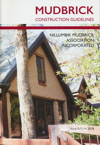
Book, Mudbrick construction guidelines, 2018
These guidelines are an updated version of the 1988 Adobe Guidelines and have been prepared to aid builders and building professionals, in understanding the requirements for projects using mudbrick construction. This book includes sections on making bricks, plans and approvals, design and detailing requirements, construction requirements and maintenance.A substantial amount of mudbrick construction has taken place throughout the The Shire of Nillumbik which has formed a significant part of its unique heritage. Softcover. nillumbik mudbrick association inc., brickmaking, mudbricks, adobe, mudbrick construction, mud bricks -
 Greensborough Historical Society
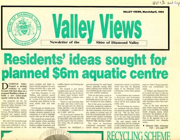
Newspaper - Newsletter, Shire of Diamond Valley, Valley Views: Newsletter of the Shire of Diamond Valley. March/April 1993, 1993_03
Local news from the Shire of Diamond Valley 1993. Includes plans for a swimming pool for the Civic area; extension to the Diamond Valley Library; extended hours for Maternal and Child Health centres; entertainment in the Shire; radio station Plenty Valley fm; and, treatment for headlice.Newspaper, 8p., green and black text, black and white images. 2 copiesshire of diamond valley, swimming pools greensborough, diamond valley library, plenty valley fm -
 Greensborough Historical Society
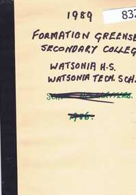
Folder of Documents, Formation of Greensborough Secondary College 1989 Gr8750, 1989_
In 1989 Greensborough Secondary College was formed from the amalgamation of Watsonia High School and Watsonia Technical School. These documents include the reorganisation proposal, minutes of the Local Planning Committee meeting held on 5th May 1988 and staff responsibility lists from 1988 and 1989.These documents indicate the changes occurring at the time of amalgamation including the responsibilities of staff.Manilla folder with black binding tape on folded edge containing 4 documents printed on A4 paper.Written in texta pen on front cover: "1989 Formation of Greensboro' [sic] Secondary College. Watsonia H.S., Watsonia Tech School"greensborough college, amalgamation, watsonia high school, watsonia technical school, greensborough secondary college -
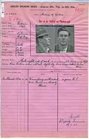 Victoria Police Museum
Prison record (Andrew Watson), 22 July 1921
Andrew Reeves was charged in June 1920 with attempting to murder Gertrude Clara Sexton by shooting her and then attempting to commit suicide by shooting himself. Watson was a partner in Mr Sexton's farm at Turriff in the Mallee. Watson and Mrs Sexton were planning to run away together. Prison record for Andrew R. Watson, prisoner registered number 35611, giving details of the prisoner, his crimes and the dates and places of his trials.english speaking prisoner, andrew reeves watson, wounding with intent, attempted murder -
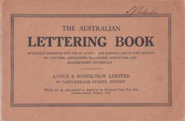 Warrnambool and District Historical Society Inc.
Booklet - Lettering Book, Halstead Press Pty Ltd, The Australian Lettering Book, 1945
Author Herbert Newell. Alphabets of varied fonts, headings, flourishes, plans, numerals, sketch maps, scrolls, shading, common errors, compass points. Especially designed for use in Australian Schools, offices of Lawyers, Architects, Surveyors, Engineers, Engravers, and Draughtsmen. Table of contentsThe author is a teacher of show card and ticket writing at Sydney Technical College. Book used by many students and offices. Note by the publishers provides standards for the correct form of the characters. Light brown light card cover with black ink font and border patterns. 32 Cream pages with black ink. Two staples. Hand written name on top of outline black border S. R Coleston. Price 3/9warrnambool, lettering book, angus & robertson limited, s.r. coleston, herbert newell -
Moorabbin Air Museum
Manual (Item) - Mirage Iii O Aircraft Planned Servicing Schedule Flight Servicings
Description: SUPERSEDES AAP 7213.001-6-1M, PUBLISHED SEPTEMBER 1982. 130 pages. Published by RAAF. Published August 1984. AAP 7213.001-6-1M. Mirage III O Aircraft Planned Servicing Schedule - Flight Servicings Level of Importance: World. -
Moorabbin Air Museum
Manual (Item) - Hs748 (Vip) Aircraft Planned Servicing Schedule - Special Servicings
Description: SUPERSEDES AAP 7211.004-6-7, PUBLISHED APRIL 1982. 50 pages. Published by RAAF. Published January 1987. AAP 7211.004-6-7. HS748.T Aircraft Planned Servicing Schedule - Functional Tests and Checks Level of Importance: World. -
Moorabbin Air Museum
Manual (Item) - Pawnee Owner'S Handbook
Description: SUPERSEDES AAP 7211.003-6-7, PUBLISHED July 1982. 150 pages. Published by RAAF. Published January 1987. AAP 7211.003-6-7. HS748 (VIP) Aircraft Planned Servicing Schedule - Functional Tests and Checks Level of Importance: World. -
Tatura Irrigation & Wartime Camps Museum
Photograph, Italian migrant boys
The boys are from Fiume, Istria a Zara They were ethnically cleansed by the Yugoslavs between 1945 and 1950, and emigrated under the UN Sponsorship Plan IRD to Australia, arriving on the M.V. Castel Bianca on 27.12.1951. Held at Rushworth Migrant Centre, known as Camp Desperation 'fortimo".Black and white photo, group of 4 boys with toddler in front of barracks. February 1952 at Rushworth Migrant Centre.rushworth migrant centre, photography, camera, accessory, photograph, slides, film