Showing 31259 items
matching buildings
-
 Ballarat Tramway Museum
Photograph - Black & White Photograph/s, Paul Nicholson, 16/06/1972 12:00:00 AM
Yields information the construction of the extension to the depot and the start of the trackwork to new area.Black and white photographs of the depot building soon after completion, before any track was laid in the building and the tramcars moved in. Photo appears in August 1972 Trolley Wire, page 16. On rear is a date stamp 16/6/1972 and photo trimming dimensions and name "Paul Nicholson".On rear in ink and pencil date stamp "16 June 1972", / "6658" / "Paul Nicholson / Photo No. 10 / Same size and letters S/S" in ink.trams, tramways, depot construction, btps, operations -
 Bendigo Historical Society Inc.
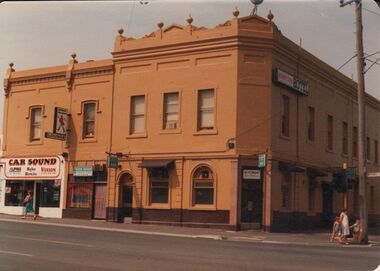
Photograph - BENDIGO HOTEL COLLECTION: HOPETOUN HOTEL
Colour image: Hopetoun Hotel, two storey building, corner of Mitchell and Wills Street. Building painted mustard brown, dark brown band at street level. Ornate finials on top storey pediment. On LH side of ground floor facing Mitchell Street 'Car Sound' business.bendigo, hotel, hopetoun hotel -
 Bendigo Historical Society Inc.
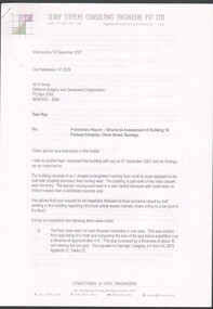
Document - Preliminary report of Structural assessment Fortuna
Fortuna Villa was initially commenced as a modest single storey home in 1861 next to the 180 Mine by Theodore Ballerstedt, who sold the mine and house to George Lansell in 1869. Lansell already owned the adjacent Fortuna Mine, and through deeper mining techniques greatly expanded the mine's operation, his personal wealth, and the house and grounds. Lansell was soon known as the 'Quartz King', Australia's first gold mining millionaire and credited as the driving force behind much of Bendigo's prosperity. He continuously added to and expanded the villa, decorating it extravagantly with the finest of artworks and materials, into a sprawling mansion with extensive landscaped grounds, to create a house and grounds of a size and grandeur with few rivals in Australia. After his death in 1907, his second wife Edith carried on with improvements, creating a house and grounds developed over 50 years. The attached mine also contributes to its significance, being one of the richest mines in Bendigo, and at one stage probably the deepest gold mine in the world at 3176 feet. The 1875 crushing works are attached directly to the mansion, and the mine's tailings and settling ponds (turned into ornamental lakes) represent a direct link between George Lansell's wealth and its source. Fortuna was compulsorily acquired by the Commonwealth in 1942 as the Cartographic Headquarters of the Australian Survey Corps during World War II, and many ancillary structures were added while preserving the main house and ornamental grounds. Victorian Heritage Database Report https://vhd.heritagecouncil.vic.gov.au/places/68334/download-reportPreliminary report of Structural assessment of Building 16 Fortuna Complex, Chum Street, Bendigo. Four page preliminary report finding the building is structurally safe as at Wed 19 December 2007 with three recommendations. Prepared for DIGO by Structural Engineers - Terry Stevens Consulting Engineers Pty Ltd.fortuna, structural assessment -
 University of Melbourne, Burnley Campus Archives
Plan (item) - Plans Burnley Gardens, Department of Agriculture - Victoria Burnley Gardens
-
 Melbourne Tram Museum
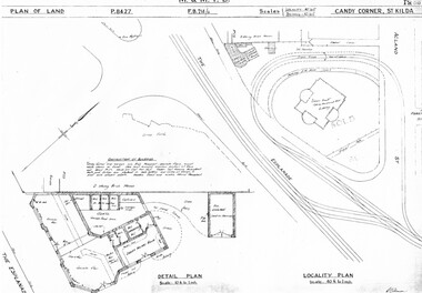
Drawing, Melbourne & Metropolitan Tramways Board (MMTB), "Candy Corner St Kilda", c1938
Set of two photocopied plans or drawings on A3 sheets of "Candy Corner St Kilda" .1 - P8427 - Plan showing locality plan, detail plan and adjacent buildings - 6-12-1938 .2 - ditto, but not the detail of the building in the centre of the island - "Green Knoll" Cafe and Amusement Park.trams, tramways, drawings, depots, property, candy corner, st kilda, turning loops -
 Kew Historical Society Inc
Plan, Melbourne & Metropolitan Board of Works. Borough of Kew Detail Plan No.1579, 1904
The Melbourne and Metropolitan Board of Works (MMBW) plans were produced from the 1890s to the 1950s. They were crucial to the design and development of Melbourne's sewerage and drainage system. The plans, at a scale of 40 feet to 1 inch (1:480), provide a detailed historical record of Melbourne streetscapes and environmental features. Each plan covers one or two street blocks (roughly six streets), showing details of buildings, including garden layouts and ownership boundaries, and features such as laneways, drains, bridges, parks, municipal boundaries and other prominent landmarks as they existed at the time each plan was produced. (Source: State Library of Victoria). This plan forms part of a large group of MMBW plans and maps that was donated to the Society by the Mr Poulter, City Engineer of the City of Kew in 1989. Within this collection, thirty-five hand-coloured plans, backed with linen, are of statewide significance as they include annotations that provide details of construction materials used in buildings in the first decade of the 20th century as well as additional information about land ownership and usage. The copies in the Public Record Office Victoria and the State Library of Victoria are monochrome versions which do not denote building materials so that the maps in this collection are invaluable and unique tools for researchers and heritage consultants. A number of the plans are not held in the collection of the State Library of Victoria so they have the additional attribute of rarity.Original survey plan, issued by the MMBW to a contractor with responsibility for constructing sewers in the area identified on the plan within the Borough of Kew. The plan was at some stage hand-coloured, possibly by the contractor, but more likely by officers working in the Engineering Department of the Borough and later Town, then City of Kew. The hand-coloured sections of buildings on the plan were used to denote masonry or brick constructions (pink), weatherboard constructions (yellow), and public buildings (grey). While MMBW Plan No.1579 does not include many buildings, those that it does show are significant to Kew’s history. These include the ‘Kew [Railway] Station’ in Denmark Street and the ‘Recreation Hall’ and rear courts off Wellington Street. The plan shows the outline of the Recreation Hall, constructed in 1880, at the rear of which is listed a bowling green, two tennis courts, a ‘skittle alley’ and a pavilion. When the Hall was first built, the Kew Cricket Club occupied an adjacent ground, however in 1885 this was acquired by the State Government as the future location of the Kew Railway Station. The Plan also shows a single oval at Xavier College. This oval was completed in 1883. One of the current ovals conforms to this oval’s original shape and position in the school grounds.melbourne and metropolitan board of works, detail plans, maps - borough of kew, mmbw 1579, cartography -
 Bendigo Historical Society Inc.
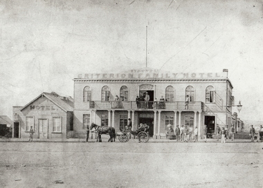
Photograph - SYMONDS' CRITERION FAMILY HOTEL BENDIGO, 1861 ?
Black and white photo: Criterion Family Hotel, cnr. Mundy and Lyttleton Terrace, Bendigo. Two storey building with 6 arched windows on top, with balcony and doorway. Balcony supported by ten pillars. On LH side of building, weather board building with two windows and doorway 'hotel' printed in between gable roof. Horse and carriage at front of hotel. See Mosaic no. 2402.49 for further details and research information. (Joseph S. Symonds the licensee 1858-1862, see 2402.49 for reference]Batchelderorganization, business, criterion hotel, criterion family hotel. mundy street hargreaves street. market square. princess theatre. symonds, joseph s. -
 Bendigo Historical Society Inc.
Photograph - PHOTOCOPIES OF POSTCARDS: BENDIGONIAN HARGREAVES ST., MITCHELL ST., CITY MARKET, BAWCEN'S DRAPERY
Photocopies: on one page, four cards. Bendigonian Series - In Hargreaves Street, Bendigo, Vic. Image shows horses and carts, Faul building. General view of Mitchell Street, Bendigo, circa 1900., Bendigonian Series, City Market Buildings, Bendigo, Vic. (? ) Bawdens Drapery Emporium - outside building D. Fletcher-Jones- Millinery Van -The Western district Travelling Draper , written on van ,There is a horse and cart which has a sign - D. Fletcher Jones, Travelling Draper.-bendigo, streetscape, mitchell, hargreaves st., bendigo, mitchell street, hargreave street, bawdens, faul. -
Bendigo Historical Society Inc.
Photograph - LA TROBE UNIVERSITY BENDIGO COLLECTION: SANDHURST HOUSE
A black and white photograph of Sandhurst House which was a hostel catering for female student accommodation from 1945 until 1959. Prior to this it was known as the Coffee Palace or Sandhurst Coffee Palace. The building was situated on the corner of Mollison and Mitchell Streets and has now been demolished. It was a two storey building with verandahs and ornate pediments. At the top of the building are two pediments each with a sign Heywood Sandhurst House. St. Paul's Cathedral can be seen in the background on the left hand side. See 3320.100bendigo, education, bendigo teachers' college, la trobe university bendigo collection, collection, bendigo, education, tertiary education, accommodation, students, building, site, place, sandhurst coffee palace, coffee palace, entertainment, photo, photograph, history, hospitality -
 Whitehorse Historical Society Inc.
Photograph, Britannia Street, Mitcham, 13/06/1986 12:00:00 AM
2 Coloured photos of Brittania Street, Mitcham. Looking North from Corner of Whitehorse Road. Shops on Western side of Britannia Street are located on the site of Barelli's shop, dwelling and bakehouse. To the north of these buildings and across a cobblestone lane now called Enterprise Way was the Salvation Army Citadel, .a further commercial building housing a printer. Erection of this building necessitated demolition of Barelli's stable and reclamation of its horseyard. The Salvation Army are now located on the Mitcham Road and Harrison Street corner.britannia street mitcham -
 Lakes Entrance Regional Historical Society (operating as Lakes Entrance History Centre & Museum)
Photograph, 1890c
Three copies -Sepia photograph showing dunes, houses and Works buildings and boats at the entrance to Gippsland Lakes from ocean - Bass Strait. Photo shows two PWD houses on left and small school building, plus other Works buildings. Flagstaff on dune above houses. Large barge on left in front of houses. Large passenger steamer at New Works wharf with people waiting, has flags and bunting, two masted ketch on right of rock groynes. Lakes Entrance Victoriajetties, township, boats and boating, topography -
 Ballarat Tramway Museum
Photograph - Black & White Photograph/s, Jim Seletto, Feb. 1958
Yields information about the appearance of Sturt St at the time of Ballarat Begonia Festival, 1957 - the flowers in the medium strip, the tram and the shoppers in particular the women.Black and white photograph of Ballarat No. 14 west bound in Sturt St during the 1957 Begonia Festival with the Town Hall (with a Begonia Festival sign on it), and other buildings in the background. Has the Australian Mutual Life Building, the Odeon Theatre buildings. In the centre median strip, there is a large arrangement of flower beds and many women shoppers crossing the road, motor vehicles and a lady on a bicycle. No. 14 has the destination of Haddon St via Drummond Nth. Festoon lighting is strung out along the street.On rear in red ink "Ballarat Car 14 Sturt St B'rat Summer '57" and the stamp of Jim Seletto.tramways, trams, sturt st, begonia festival, town hall, shoppers, tram 14 -
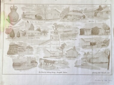 Wodonga & District Historical Society Inc
Work on paper - Sketch - The School of Military Survey, Bonegilla, 1970s
Bonegilla operated as an army base from September 1940 and by 1943 was expanded to 848 buildings, including a general hospital. It provided training for small arms instructors, signallers, transport workers, bomb disposal and gas warfare personnel. In a response to the need to house the growing number of displaced persons coming to Australia, the Bonegilla Reception and Training Centre began operating in 1947. For some time it was a shared facility but the Army withdrew temporarily from Bonegilla in 1949, whilst still retaining ownership of the site. From 1949-65 Bonegilla Reception and Training Centre operated without a military presence. However, in the late 1960s and Australia’s commitments to the Vietnam War and pressed by the need to find accommodation to train men, especially National Servicemen, the Army negotiated with the Department of Immigration to take over several blocks at Bonegilla in 1965. Thirty-five huts were acquired by the Royal Australian Army Ordnance Corps as a Recruit Training Centre in which National Servicemen and recruits could attend 10-week ordnance courses. Shortly afterwards additional huts were acquired by the School of Military Survey, which established field-survey practical training areas and special astronomical observation sites as it began conducting courses in surveying. Instructors and trainees co-located at Bonegilla with migrant reception centre. In 1971 the Reception Centre closed and the site reverted to the Army. Progressively after 1971 the Army undertook a major site redevelopment with the construction of Latchford Barracks as the Army Apprentice School. Later Latchford Barracks was redeveloped into part of the Army Logistic Training Centre. Block 19 of the Mirant Reception Centre later became the Bonegilla Migrant Experience Heritage Park.This item depicts a heritage listed historical site located in the Wodonga district.A large poster size representation of the variety of buildings at Bonegilla, Victoria when it served as the location for the Royal Australian School of Military Survey. The insignia of the Royal Australian Survey Corps is featured in the top left hand corner.Top left corner: Insignia of the Royal Australian Survey Corps At bottom of sketches: "The School of Military Survey, Bonegilla Victoria / January 1966 - December 1982migrant reception centre bonegilla, army at bonegilla, australian military -
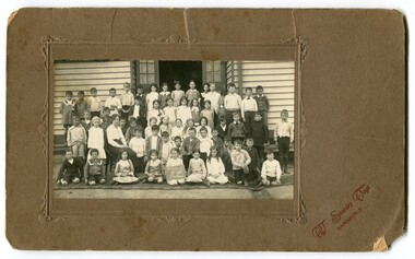 Orbost & District Historical Society
black and white photograph, Vogt. W.S, early 20th century
This is the annual photograph of Grades 111 and 1V for pupils of the Orbost State School. The 19th of March 1886 proved an important day in the lives of many early settlers in the Orbost area, because on this day the Orbost State School opened. The fact that the school had first operated temporarily in a leased building, and on a half-time basis with SS2745 Jarrahmond, did not dampen the enthusiasm of the local inhabitants as they saw their offspring commence their education under the guidance of Head Teacher Campbell Mackay. However he remained in charge only until 12th of May 1886. The second Head Teacher, John Rowe, served until 1908. On 30th of June 1887, a portable room was provided; it being brought to the area by schooner. The school now had accommodation for 30 pupils; the teacher's welfare was considered because quarters of two rooms were attached. As the population increased so did the needs of the school. This was reflected in the provision of a larger classroom in 1898. This item is associated with the history of education in Orbost.A black / white photograph mounted on brown car. There are five rows of school children standing outside a wooden building. Some are sitting and others standing. A female teacher is seated on a chair in the second front row. A girl in the front row is holding a card - "Grades 111 & 1V Orbost".on front - "W. Stanley Vogt Bairnsdale"orbost-state-school education-primary-schools -
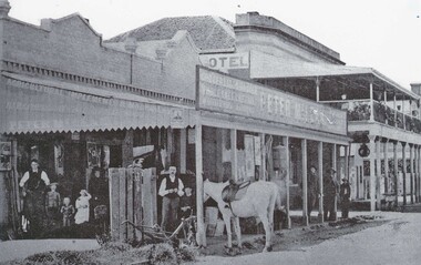 Wodonga & District Historical Society Inc
Photograph - Peter McLean's General Store and the Terminus Hotel, Wodonga, C. 1874
The Terminus Hotel, Wodonga was built by James Thompson Hatch in 1873, the same year the railway reached Wodonga from Melbourne. It was named due to its close proximity to the railway terminus. It was sold to Messrs George Day and Kenneth McLennan of Albury. It was first licenced to J.G. Morton in January 1874. Annie Allen, from Ireland, took over as licensee of the hotel containing 14 rooms in 1879, after she and her husband, George James Allen, purchased it. In 1887 they added a new wing on the south boundary of the property next to Peter McLean’s store at 81 Sydney Road. The architects for the new wing were Gordon and Gordon. A billiard room, a dining room, and 18 other rooms were added on the vacant block of land between the Hotel and the Bank of Victoria. A balcony 6 feet wide was added on the north side. Included in the plans was the latest patent elevator, later known as a dumb waiter. Allen died in 1889 aged 52, and Annie Allen continued to run the Terminus. She later married John G. Haldon and was licensee of the hotel until December 1898 when the licence was transferred to William Carkeek. Carkeek, from Cornwall, arrived in the colony around 1860 and is considered one of the founders of Tallangatta. In November 1903, the license was transferred to Daniel Crawford, then in 1906 it was transferred to Mr Stephen Carkeek. In 1916 it passed into the hands of Mr H. W. Allen of Rutherglen, son of Mr George James Allen. Between 1916 and 1933 there were a variety of licensees. In October 1933, the stables and garage at the rear of the Terminus Hotel were totally destroyed by fire. In 1935, the Terminus again underwent a series of improvements and extensions at the cost of £3,000. The front of the premises was extended in the fashionable Spanish mission style. The balcony of brick and concrete was extended to be 18 feet wide, wire gauged and fitted with glass slides and a tile roof. In addition to 15 new bedrooms, four more bathrooms, making seven in all, were available for patrons. These were on the second floor, while beneath them provision was made for four shops and a new kitchen and a laundry. Throughout the 1930s and 1990s the licensee and owners changed several times. On 1st June 1998 the Terminus Hotel was destroyed by fire. Estimates of damage range from between a conservative $750,000 to as high as $2 million. The remains of the building were demolished in 1999.The Terminus Hotel was one of the earliest hotels in Wodonga with clear links to the establishment of the railway line. It was an important business and meeting place for social gatherings.Oldest available photo of the Terminus Hotel beside Peter McLean's Wholesale and Family Drapers General Store. These buildings were on the west side of Sydney Road, later renamed to High Street.hotels wodonga, businesses wodonga, terminus hotel wodonga -
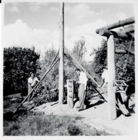 Falls Creek Historical Society
Photograph - Bogong 12 July 1953
This photo is part of the Fred Griffith Photographic Collection documenting his time with the Australian Alpine Club and the formation of the Albury Ski Club. Frederick Charles “Fred” Griffith was born in Albury, NSW on 2 March 1910. Educated in Albury and Geelong Grammar. Beginning in 1927 he spent many years working first as a jackeroo and on a range of prominent pastoral and merino stud properties in NSW and Queensland. In 1935 he repurchased his former family property “Toonallook", Bowna, NSW and developed it to be the largest Romney Marsh stud in the world, exporting rams to Argentina. He introduced many innovative practices on his property including rabbit control measures and aerial crop dusting. He was an active member of the Albury Show Society and in 1949 established the Albury Sheep Show. Fred was also the Albury representative on the Graziers’ Association Council for over 30 years. He became a life member of both the Albury and Commercial Clubs. Fred’s greatest hobby was snow skiing. His first visit to the snow was to Kosciusko in 1919. The Albury Ski Club was formed in 1935 and Fred was an inaugural member. In 1949 they were granted a site at Falls Creek to build their own lodge. Fred guaranteed the Club for finance from the Bank of NSW. The first portion of the prefabricated building was constructed in Albury. It was transported to Falls Creek on the back of Fred’s truck and erected in one day. This was the bathroom section and the rest was completed in 1950. The original lodge was burned down in 1952 and a new one built the following year. In 1955, Fred also built the Bowna Lodge for his family in partnership with David Fairbairn. He became head of the North Eastern District Skiing Association (N.E.D.S.A.) and successfully applied to run the Australian Ski Championships. Fred also inaugurated children’s races at Falls Creek and ran them for about 20 years. He also formed the company “Falls Creek Ski Tows”. In 1956 Fred along with a group of key people selected the site for Thredbo Village. Fred and his brother sold Toonallook in sections between 1951 and 1974. He moved to Albury and set up as a landscape gardener and fencing contractor. After a serious work accident, Fred retired in 1985 and moved to Rosebud, Victoria where he died on 19 August 1992. This image is from the Fred Griffith Collection which documents early development of Falls Creek.Black and white square photograph of three men working on a tall wooden structure with a central tall pole. Trees and sky in the background, with grass in front and a wooden building structure at right of image. Stamped - SUPER / G & D . SERVICE Pencil - 61bogong, falls creek, snow, snowfields -
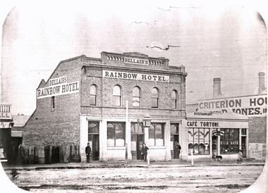 Federation University Historical Collection
Photograph - Black and White, Solomon and Bardwell, Bellair's Rainbow Hotel, Ballarat
According to Reid and Chishold in 'Ballarat Golden City' "Rainbow Hotel Sturt Street: on the north side near Armstrong Street was built in the 1860s. It was demolished to may way for Lester's Hotel"Double storey brick building with a lamp over the front door. The building is Thomas Bellair's Rainbow Hotel. Cafe Tortoni and Criterion House are also evident in the image. Three men stand outside the Rainbow Hotel, and a woman and dog are shown outside Cafe Tortoni. Gift of the Keith Rash Estatebellair, thomas bellair, rainbow hotel, lestor's hotel, sturt street, armstrong street, streetscape, cafe tortoni, criterion house -
 Bendigo Historical Society Inc.
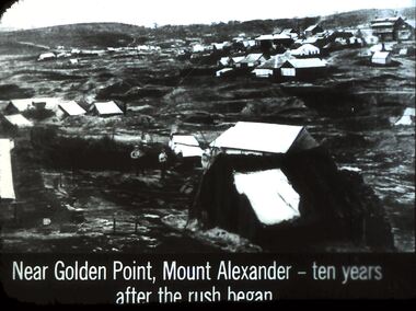
Slide - DIGGERS & MINING. DIGGERS AND MINERS, c1861
Diggers & Mining. Diggers and miners. Near Golden Point, Mount Alexander - ten years after the rush began. Photo shows many tents and some timber buildings at least one two story building up on the hill. Markings: 19 994:LIF I. Used as a teaching aid.hanimounteducation, tertiary, goldfields -
 Bendigo Historical Society Inc.
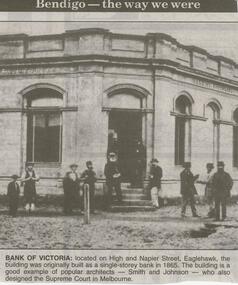
Newspaper - JENNY FOLEY COLLECTION: BANK OF VICTORIA
Bendigo Advertiser ''The way we were'' from 2000. Bank of Victoria: located on High and Napier Street, Eaglehawk, the building was originally built as a single-storey bank in 1865. The building is a good example of popular architects - Smith and Johnson - who also designed the Supreme Court in Melbourne. The clip is in a folder.newspaper, bendigo advertiser, the way we were -
 Bendigo Historical Society Inc.
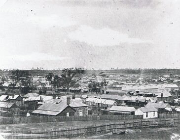
Photograph - STREETSCAPE: BENDIGO, 1857 ?
Black and white photograph. View of Bendigo Many small buildings, weatherboard, stone, paling. Trees on horizon, Beehive stores in middle distance. Rough vertical stick fences, fencs in foreground. Taken from high ground. In image on parapet of building in middle distance ' Francis Brothers Beehive Stores'A. Fox ( James Lerk 11.2.2000 )place, streetscape, bendigo -
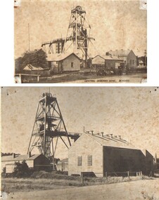 Bendigo Historical Society Inc.
Photograph - CENTRAL DEBORAH MINE, a) c.1900 b) 1920
Black and white photographs X 2. A) Corrugated iron mine buildings, poppet head and walkway. B) Different view of mine and buildings with a couple of trucks. Inscriptions: A) Central Deborah written on back. B) Central Deborah Mine Bendigo on front. 'Valentine's post card. Genuine photograph on back'.topic, mining, central deborah mine -
 Bendigo Historical Society Inc.
Photograph - EDITH LUNN COLLECTION: BENDIGO BANK FROM SANDHURST CLUB
Two views looking across the rear of properties on View Street Taken 28/08/1997 B8A looking across to the Bendigo Bank from the veranda of the Sandhurst Club Bendigo Bank building at Charing Cross 8Brear of the National Australia Bank building and into the entrance of the Samdhurst Club, on View StreetEdith Lunn -
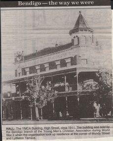 Bendigo Historical Society Inc.
Newspaper - JENNY FOLEY COLLECTION: HALL
Bendigo Advertiser "The way we were" from 1999. Hall: The YMCA building, High Street, circa 1911. The building was sold by the Bendigo branch of the Young Men's Christian Association during World War II when the organisation took up residence at the corner of Mundy Street and Lyttleton Terrace.newspaper, bendigo advertiser, the way we were -
 Bendigo Historical Society Inc.
Document - BENDIGO AND ITS HISTORICAL ASSOCIATIONS
Typed notes titled 'Bendigo and its Historical Associations. Mentioned are the buildings that were erected between the 1870's and the turn of the century, the buildings and churches, the meeting of diggers and the formation of the Red Ribbon League,the early gold miners, the purchase of the Central Deborah Mine, the Bendigo Easter Fair , the Chinese, and Eaglehawk.document, bendigo and its historical associations, lake eppalock, the beehive, beehive chambers, post office, law courts, shamrock hotel, town hall, home and hospital for the aged, bendigo base hospital, hospital hill, forest street wesley, congregational, st johns presbyterian, all saints pro-cathedral, red ribbon league, sacred heart cathedral, a n z bank, atkinson's building, holland bros, a h q survey regiment headquarters, george lansell, fortuna, pioneer, j b lazarus, theodore ballerstedt, victoria quartz mine, wm rae, witscheibes 'jewellers shop', gold mines hotel, david sterry, the bendigo and district tourist association, city council, central deborah gold mine, victoria hill, sun loong, loong, bendigo easter fair, chinese joss house, white hills cemetery, st killian's church, log lock-up, whipstick forest, a richardson, bendigo branch royal historical society of victoria -
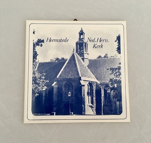 Dutch Australian Heritage Centre Victoria
Wall Tile (Tegel), Mosa
(a) and (b) - A set of two ceramic wall tiles featuring historic buildings in the town of Heemstede in the province of North Holland. The images are in shades of blue. Tile (a) depicts the Dutch Reformed Church building (Netherlands Reformed Church). Tile (b) is an image of the Cruquius Museum on the site of a one-time pumping station.On the back of each tile are the words Mosa Royal Holland. Tile (a) also has the numbers 86 and 89 imprinted. -
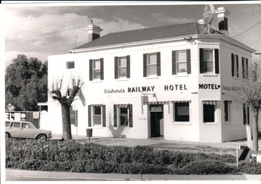 Hume City Civic Collection
Photograph, Mid 1970s
The Railway Hotel in Sunbury was owned and operated by the Edwards family until Dawn Edwards died in 2004. It is situated on the corner of Station and Evans Streets and over the years has undergone many changes to accommodate the changes in liquor and gaming laws.A black and white photograph of the Railway Hotel, renamed The Olive Tree. The building is sited on a corner block. it is a two storey building with seven windows on the upper floor and eight on the ground floor as well as a doorway. A Holden station wagon is angle parked on the LHS and two bare trees are growing on the nature strip.hotels, motels, evans street, edwards, dawn, railway hotel, olive tree hotel, george evans collection -
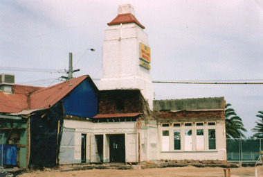 Lakes Entrance Regional Historical Society (operating as Lakes Entrance History Centre & Museum)
Photograph, Holding M, 2005
Date made May 2005Colour photograph of the rear of the Central Hotel, showing what is left of the building after all the debris was cleared, to facilitate refurbishment and construction of new cafe and bistro. The photo shows all materials used in previous construction of original building, tower and window remain on 1930 frontage. Lakes Entrance Victoriahotels, construction, restaurant, architecture -
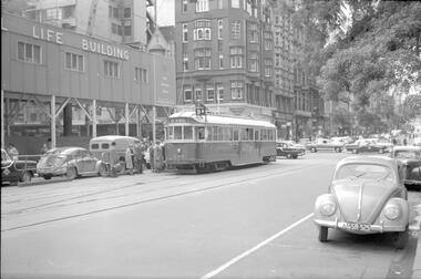 Melbourne Tram Museum
Negative, Travis Jeffrey, 28/09/1961 12:00:00 AM
Negative of tram 644 at tram stop in Collins St at Elizabeth St. Several buildings appear in the background in Elizabeth St which are still there. Construction site of Colonial Mutual Life building in background. Tram has destination East Preston - Bell St and route 9A and is flying an Australian flag.Paper folder that contained the negative had "NR53A" in red ink, "M8" in pencil, 43A in blue ink, date stamp "28 Sep 1961" on front, and on rear date stamps "26 Sep 1962" and "6 Oct 1962"trams, tramways, sw2 class, collins st, tram 644 -
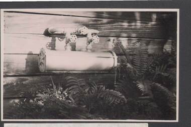 Bendigo Historical Society Inc.
Photograph - BILL ASHMAN COLLECTION: SCALEBUOY MOUNTED ON SIDE OF BUILDING
Black and white photograph of a Scalebuoy mounted on the side of a building. Scalebuoy is a long cylinder with two pipes coming from the top, each with a gate valve. They are joined to a loop pipe with each end going into the building. It has a gate valve in the centre. Each end of the cylinder are removable. In the foreground are some ferns.sciences, instruments - general, scalebuoy, bill ashman collection - correspondence -
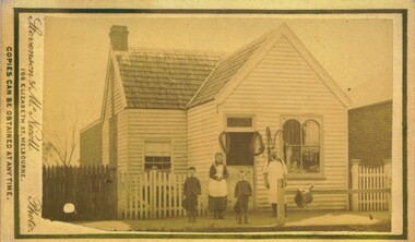 Bacchus Marsh & District Historical Society
Photograph, Thomas Heath's Saddlery Main Street Bacchus Marsh 1883
Thomas Heath built this shop for his saddlery business around 1875. In 1926 after 58 years operating his saddlery in Bacchus Marsh he retired and the assets of his business were sold in a clearing sale. The building was later demolished. Apart from his services in saddlery his premises was known to be a gathering place for much discussion. Heath was known to openly express his political opinions and his saddlery premises was known by many in the community as the 'Parliament'.Small sepia unframed photograph on card with gold border framing photograph. Housed in the album, 'Photographs of Bacchus Marsh and District in 1883 by Stevenson and McNicoll'. The photo is of a double-fronted weatherboard building with a shingle roof. The front gabled section stands on street level flanked by a picket fence. The door and overhead window and the side window with arched panels may indicate that this was the shop section, with a dwelling to the rear. Items which may be for sale can be seen hanging in the windows. The recessed side section of the building with a twelve-sectioned window, chimney and a back extension was probably the dwelling used by the family. On the footpath stands the saddler with three children, two boys and an older girl, probably Mr Thomas Heath and the Heath children. A hitching rail runs along the front of the workshop. Indicating the type of business Mr Heath ran, are a saddle placed over the rail and two horse collars and reins hanging either side of the workshop door. On the front: Stevenson & McNicoll. Photo. 108 Elizabeth St. Melbourne. COPIES CAN BE OBTAINED AT ANY TIME. On the back: LIGHT & TRUTH inscribed on a banner surmounted by a representation of the rising sun. Copies of this Portrait can be had at any time by sending the Name and Post Office Money Order or Stamps for the amount of order to STEVENSON & McNICOLL LATE BENSON & STEVENSON, Photographers. 108 Elizabeth Street, MELBOURNE. saddleries, saddlers, thomas heath 1842-1930 saddler