Showing 17197 items matching "bay-bridge"
-
 Lakes Entrance Historical Society
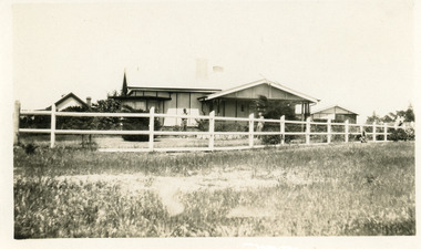
Photograph - Historic House, 1930
House built in Roadknight Street, by Ernie Ault, local builderBlack and white photograph of the residence of Rex and Mac Harbeck, seen in garden showing a cement sheet house with gable roof, unusual bay window across N E corner, white timber fence posts and rails with wire netting attached, established garden. Lakes Entrance Victoriahouses, local history -
 Lakes Entrance Historical Society
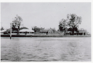
Photograph - Nithsdale, 1920 c
Nithsdale' built 1890c by Barke Brothers, early storekeepers of Lakes Entrance, occupied by William, John and Mrs Jane Barke (mother). After 1920c lived in by members of the Coate/Symmons families. Later sold to Zagami and Crea, then lived in by Richard and Marlene Rijs - late 1970's, early 1980's. Later again sold to Tromp and relocated to Lake Tyers Beach in the late 1980's or early 1990's.Black and white photograph of a late Victorian style dwelling on Esplanade. Iron hipped roof veranda on twosides, bay window in front room. Two chimneys, picket fence. Set between guest house and general store. View of lake and bluestone wall in foreground. Lakes Entrance Victoriahouses, local history, people -
 Flagstaff Hill Maritime Museum and Village
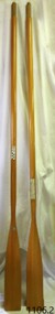
Equipment - Rowing Oar
The family-owned timber manufacturing business Pelco was started by Cecil Victor Woodfield in 1937. The joinery company Pelco began by making wooden ladders and was registered as the Palmerston Extension Ladder Company. C V Woodfield, who lived from 1884 -1959, arrived in Palmerston North from Canterbury NZ in the aftermath of the Great Depression to work in construction. The company got its first step up when Woodfield was asked by a commercial painter to make a ladder, and the founder set up shop in a garage on Ruahine St. According to the company website, Pelco made its name in New Zealand with its Oregon Extension Ladders, and up until its closure, manufactured non-conductive Lamilite Ladders for the electrical supply and service industry worldwide. The company was incorporated as a joinery business in 1946 and continued making high-end cabinetry for seven decades. Under director Geoff Woodfield, in the 1950s, the company embarked on the production of Fleetcraft plywood boats. Another water-related enterprise followed, with the manufacture of oars and paddles. Its branded Gull Superior Oars and Paddles business began exporting in 1972 to Australia and subsequently to the United States, UK and Japan. The company ceased trading in April 2018 and was placed into receivership.This pair of lightweight oars represents the maritime tradition of handmade oar making, which has evolved over the centuries. Their shape is still similar to early oars and continues to serve the same purpose, to steer and propel a boat. Pair of blonde varnished Tasman Fir oars with a flattened paddle at one end. Made by Gull of New Zealand, sold by James Edwards & Sons of Melbourne. Inscriptions on printed labels on the oars."GULL Superior Oars and Paddles, Pelco, Palmerston North NZ" "JAS. EDWARDS & SONS, Boat Builders, Oar and Skull Makers, & Importers, PRINCES BRIDGE MELBOURNE"warrnambool, flagstaff-hill, flagstaff-hill-maritime-museum, maritime-museum, shipwreck-coast, flagstaff-hill-maritime-village, oar, oars, gull oars and paddles, new zealand oars and paddles, jas edwards and sons melbourne, rowing equipment, new zealand oak, paddle, james edwards and sons melbourne, james edwards, tasman fir, gull superior oars, marine equipment, marine technology, ship fitting, boat fitting, rowing oar, boat oar -
 Ringwood and District Historical Society
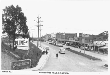
Photograph, Maroondah Highway Central, Ringwood. Whitehorse Road looking west from Warrandyte Road. c1930's
Black and white photograph (2 copies)Inscribed on photograph: "Series No 4. Whitehorse Road, Ringwood. Image shows shops on north side of road from Warrandyte Road railway bridge to Ringwood Street. -
 Bendigo Military Museum
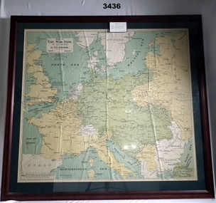
Map - WAR ZONE EUROPE, FRAMED, Post WW1
Brown wooden frame with glass front & fawn paper backing. Mounted is a coloured map of the war zone in Europe. A thin white line represents the approximate line of contact between the opposing forces at the end of the 1st year of war in 1915.Printed top left: “Map of The War Zone in Europe by H E C Robinson Sydney - Copyright” On back: “Bethany Gallery, 116 Bridge Street, Bendigo”map, framed, war zone, european -
 Greensborough Historical Society
Photographs, Plenty River Flood 1974, 1974_05
Five photographs of the Plenty River in flood 1974, taken around Greensborough by June and Brian Roberts.Five photographs b & w; one note with #3#1: Plenty River may '74 flood. Flintoff St. bridge wrecked #2: [Unmarked]? #3: Plenty at Greensborough1974 flood (Note: "The house on left hand side of the picture - would it be the Medical/dental #4: Rand St. foot bridge remnants (Plenty R.) May '74 #5: Debris dumped on park by Plenty R. flood May 1974 floods, plenty river -
 Bendigo Military Museum
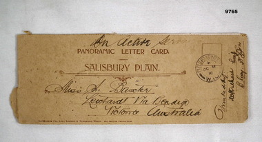
Card - PANORAMIC LETTER CARD, Hotocrom Co. Ltd, c.1916
Sent home by Capt. Frederick Baxter MC. Part of the Baxter Collection. Refer Cat No.4219.Cream colour panoramic card Salisbury Plain. Inside 4 pages with 8 images of Army Barracks or tourist sites. On front is address sent to in Australia, Post Office stamp and signed off by Battalion. Photos are all labelled as per inscription and held together by one staple.Photo's labelled. Top written "On Active Service". 1. 40857 Bulford Camp. 2. 48060 Bulford Camp B Lines. 3. 36891 Bulford Camp near Salisbury. 4. 36868 Salisbury Plain, Tidworth Barracks. 5. 36889 Bulford The Bridge. 6. Amesbury, Queensbury Bridge. 7. 32482 Salisbury Stonehenge. 8. 32478 Salisbury Cathedral.letter card, baxter collection, ww1, baxter mc -
 Victorian Interpretive Projects Inc.
Photograph - Black and White, Ballarat, c1854
The town you see had over 50,000 people. Bridge Street on the left is well established. The crude pans and cradles of the early “diggers’ were already giving way to steam power and the deep shafts of the “miners”. Money and machinery were needed to get to the deeper leads, and the smoke stacks of the great company mines can be seen across the photo.Four black and white photographs placed together to make a panorama of Ballarat looking towards Mt Warrenheip. On the left the chimney and gasometer indicate the corner of Dana Street and Albert Street. This is now the Ballarat Law Courts. The photograph is behind glass in a black frame. These four photographs were taken from the slope of the Ballarat School of Mines where the Uniting Church now stands. When joined they give a panoramic view of one of the world’s richest alluvial goldfields. The Waterloo Mine was one of the first deep shafts and was sunk at the foot of the Dana Street hill. Its tailings are seen in the second photo from left. The following was typed and placed with the framed image. Ballarat Circa 1858 This is the most significant of the photographs of early Ballarat. The photographer stood on the slope near S.M.B. where the Wesley Church now stands and took four pictures. When joined them have this panoramic view of one of the world's richest alluvial goldfields. Seven years earlier this landscape was empty. The town you see had over 50,000 people. Bridge Street on the left is well established the Ballarat gas Company stands on the same place as today. The crude pans and cradles of the early "diggers" were already giving way to steam power and the deep shafts of the :"miners". Money and machinery were needed to get to the deeper leads, and the smoke stacks of the great company mines can be seen across the photo. The Waterloo mines was one of the first deep shafts and was sunk at the foot of the Dana Street hill. Its tailings are seen in the second photo from the left. ballarat, ballarat townscape, panorama, waterloo mine -
 Queenscliffe Maritime Museum
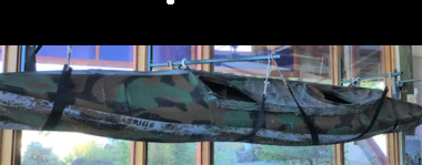
Vehicle - Kayak, Commandos
The remarkable story when 74 soldiers fought in vain to save the lives of their mates off Portsea as 3 soldiers died. Tragically, Privates Roger Wood and Edward Meyer, and Warrant Officer George "Taffy" Drakopoulos, died. Please Note: "The Rip" is also known as "The Heads", which is a dangerous stretch of water connecting Port Phillip Bay and Bass Strait. This is the only entrance for all shipping into Port Phillip Bay and to and from the Port of Melbourne, Victoria, Australia.Kayak of a similar type as those used during the ill-fated army exercise with loss of life in the rip.rip disaster, commandos, kayak, military history - army -
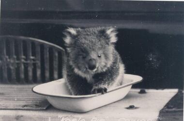 Phillip Island and District Historical Society Inc.
Photographs, Kodak, Early 20th Century to mid 20th Century
A collection of a group of photographs donated to the Society by Lun Blom, from the Photo Shop in Thompson Avenue, Cowes (was opposite the museum)A collection of 19 photographs of Phillip Island and surrounds. 293-01. Koala sitting in enamel bowl on table 293-02. 20 farmers having a break. 293-03. Reproduction of painting of The Nobbies. 293-04. Photograph of a Trophy for 1st prize for ploughing won by Mr L Morrison 1859. 293-05. Photograph of three men standing in front of a motor vehicle. 293-06. Photograph of view of Cleeland's House at Cape Woolamai. 293-07. Photograph of a whale beached on Phillip Island with people standing around it. 293-08. Photograph of a family and children in front of car - unknown. 293-09. Photograph of a painting of "Innishowen" Harbison's Property. Mr Harbison's portrait inset on the painting. 293-10. Photograph of an early map - possibly drawn by Bass & Flinders. 293-11. Photograph of the San Remo-Westernport Hotel, with vehicles in front. 293-12. Photograph of a fishing boat at the San Remo Jetty with the township in the background. 293-13. Photograph of a couta boat under full sail in Westernport. 293-14. Photograph of an aerial view of the Two Bridges taken from San Remo side. 293-15. Photograph of the Mutton Bird Eggers Camp - Bergins Bay Cape Woolamai. 293-16. Photograph of a Steam ferry decorated with flags. 293-17. Photograph of Fisherman's hut at Cowes with pier in the background. Possibly Mr Cox's. 293-18. Photograph of a couple standing on the bridge in Lover's Walk Cowes. 293-19. Photograph of an aerial view of Phillip Island looking towards Mornington Peninsula and the Heads to Port Phillip Bay in the distance.293-01. "Koala Pie" Cowes. 293-06. Mr Cleeland's Station. 293-09. "Innishowen" Mr. Harbison. 293-10. Phillip Island. 293-17. Phillip Island - Fisherman's Hut, Cowes. 293-18. Phillip Island - Lover's Walk, Cowes.wildlife - koala, wildlife - whale, the nobbies, ploughing trophy, cape woolamai - cleeland's house, innishowen, mr harbison, phillip island map, westernport hotel san remo, fishing boat san remo pier, couta boat westernport, the two bridges san remo, mutton bird eggers camp, steam ferry, fisherman's hut cowes, lover's walk cowes, aerial view of phillip island, lyn blom -
 Greensborough Historical Society
Photograph Collection, Richard Pinn, Plenty River 1979, by Alan Pinn, 1979_
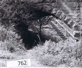
Photographs of the Plenty River Greensborough. One shows Richard Pinn walking his dog (Jah) on track by river, the second photo is a close up of the Greensborough Bluestone Bridge and steps to river. The bridge has since been demolished and the path replaced by a concrete bike/walking path.Shows the river pathways and bluestone bridge in the 1979.2 b&w photographs.plenty river, greensborough, richard pinn -
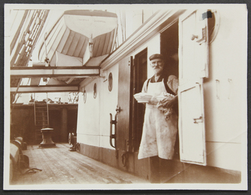 Mission to Seafarers Victoria
Photograph - Photograph, sepia, Mr and Mrs Gurney Goldsmith, Dinner is served on board a sailing ship - The Steward Serves the Cabin Dinner, 1906
The photograph was taken on board the English four-masted barque Crocodile which was a a regular visitor of the Port Phillip bay ports, transporting wheat from Australia to the UK. A rare photograph of a ship's cook, a vital crew member on a voyage.Sepia photograph depicting the cook holding a tureen on board the ship Crocodile.Written in pencil at the back: "12"cook, barque crocodile, liverpool, tureen, goldsmith album, life on board, meals, steward -
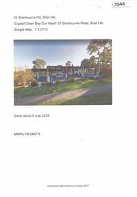 Greensborough Historical Society
Article and Photograph, Crystal Clean Car Wash, 01/08/2019
Crystal Clean Bay car wash, 35 Sherbourne Road Briar Hill was demolished about 5 July 2019. The site is being redeveloped with residential units.1 page colour photograph and captioncrystal clean bay car wash, sherbourne road briar hill -
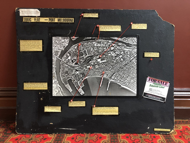 Port Melbourne Historical & Preservation Society
Mixed media, Robert Frost, Toxic Flat - Port Melbourne, 1987
Produced by Robert Frost of Alfred Street for use in Bay Street informational stalls by Port Melbourne 'Residents' Picket Group' against the SCDC Bayside development, 1988Large black display board with captions of environmental information connected by string to points on an aerial photo of Port Melbourne/Fishermen's Bend; indicates sources of contamination in Port Melbourne and on the bend.public action campaigns, environmental issues, town planning - proposals shelved - bayside, fishermans bend, industry - manufacturing, robert frost, residents picket group, british petroleum group, elders ixl, glazebrook paints, csiro, state electricity commission -
 Peterborough History Group
Booklet - 1934 Western District Centenary Magazine, Terang Express, Western District Centenary Souvenir, 1934
"The Western District Centenary Souviner"Published in 1934 as an anniversary edition for Edward Henty making his historic landing on the shores of Portland Bay on November 19, 1834Has tourism and business advertisements for Peterborough businesses. Refers to families and and early settlers of Peterborough. Sold for ? in Barry Jenkins General StoreA magazine shaped booklet. Cover replaced with wall paper and bound with tape and string. Forward stuck to front cover. Browned with age and taped on a few pagesWholly set up, Printed and Published at THE TERANG EXPRESS""Office, Terangmoyne shire, peterborough 3270, western district souvenir, peterborough general store, london bridge, great ocean road -
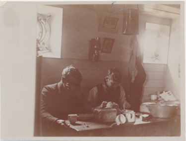 Mission to Seafarers Victoria
Photograph - Gelatin silver photograph, Mr and Mrs Gurney Goldsmith, Dinner is served on board a sailing ship - Eating It in the Half Deck, 1906
The photograph was taken on board the English four-masted barque Crocodile which was a a regular visitor of the Port Phillip bay ports, transporting wheat from Australia to the UK. A rare photograph of seamen's intimate life on board.Sepia photograph depicting two seamen sitting at a table in the galley of the ship Crocodile. In the background we can see the portholes of the ship. On the table, there is a loaf bread, tin cups and ware. One of the sailors is holding is forehead with his hand and the other one seems like is eating.Written in pencil at the back: "12"cook, barque crocodile, liverpool, tureen, goldsmith album, life on board, meals, steward, portholes, galley, kitchen -
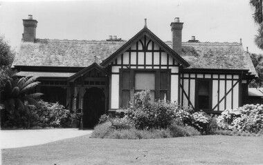 University of Melbourne, Burnley Campus Archives
Photograph - Black and white print, Principal's Residence, 1926-1941
Note by T.H. Kneen 19 November 1991, "this photo is later than B91.5-note replacement of bay windows by picture window in A.W. Jessep's time as Principal."Blsck and white photograph. Front view of house.a.w. jessep, principal, principal's residence, principal's house -
 Orbost & District Historical Society
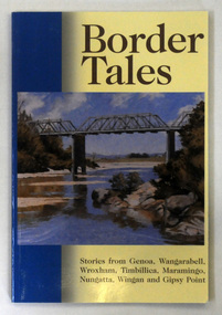
book, Border Tales, 2000
The book was compiled by Peter Allard and Geoff Alves and published by the Genoa Town Committee. Genoa is a small town in East Gippsland, Victoria. It is close to the New South Wales border where the Princes Highway crosses the Genoa River.A paperback book of 120pp titled Border tales : stories from Genoa, Wangarabell, Wroxham, Timbillica, Maramingo, Nungatta, Wingan and Gipsy Point. On the front cover is a coloured picture of the bridge across the Genoa river at Genoa. -
Federation University Historical Collection
Book, Effective Teaching and support of students from low socioeconomic status backgrounds: Resources for Australian higher education Final Report 2012
Federation University is a higher education facility, therefore this is a usuable resourceA4 sized coloured book with the title Effective Teaching and support of students from low socioeconomic status backgrounds: Resources for Australian higher education Final Report 2012. Image of bridge amonghst trees on the the cover effective teaching and support of students from low socioeconomic status backgrounds: resources for australian higher education final report 2012, australian goverment office for learning and teaching, resources for australian higher education -
 Bendigo Historical Society Inc.
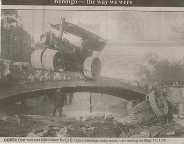
Newspaper - JENNY FOLEY COLLECTION: OOPS!
Bendigo Advertiser ''The way we were'' from Monday, March 5, 2001. Oops!: one man was killed when Kings Bridge in Bendigo collapsed under testing on May, 14, 1901. The clip is in a folder.newspaper, bendigo advertiser, the way we were -
 Bendigo Historical Society Inc.
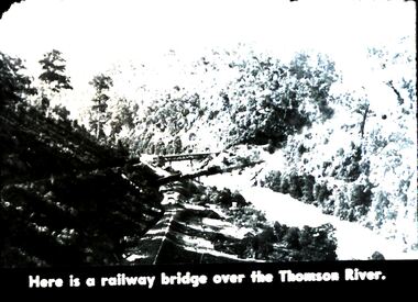
Slide - DIGGERS & MINING. DIGGERS AND MINERS, c1850s
Diggers & Mining. Diggers and miners. Walhalla - Gold Town. Here is a railway bridge over the Thomas River. Picture shows the lush growth along the river. Markings: 26 995 WAL. Used as a teaching aid.hanimounteducation, tertiary, goldfields -
 Bendigo Historical Society Inc.
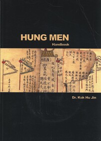
Book - HUNG MEN HANDBOOK, 2002
Hung Men Handbook. Includes a CD ROM, notated with book no. 388. Contents include formation of the Chinese Association, the Clans and the Secret Societies. Donated by Golden Dragon Museum, 5-11 Bridge Street, Bendigo.Dr Kok Hu Jinbendigo, chinese, history clans and secret societies -
 Bendigo Historical Society Inc.
Document - ANCIENT ORDER OF FORESTERS NO. 3770 COLLECTION: RECEIPT
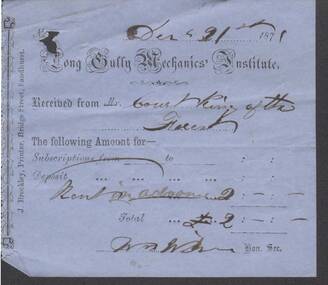
Blue receipt from the Long Gully Mechanics' Institute. Received from Court King of the Forest for Rent in advance. Total £2. Signed ? Hon. Sec. Printed by J. Brackley, Printer, Bridge Street, Sandhurst.societies, aof, correspondence, ancient order of foresters no. 3770 collection - receipt, long gully mechanics' institute, court king of the forest -
 Bendigo Historical Society Inc.
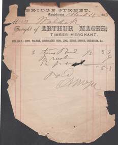
Document - ARTHUR MAGEE, BRIDGE ST SANDHURST
Arthur Magee, Timber Merchant Bridge Street Sandhurst invoice dated March 13th 1885 issued to Mrs Walder for the purchase of 3 tins of paint, brush and one and a half pints of turps. Illegible signaturebendigo, industry, hardware sales, arthur magee. paint prices 1885 -
Port Melbourne Historical & Preservation Society
Photograph - Railway reserve, looking from Bridge Street, Port Melbourne towards the city, 1950s
B&W photo of the railway reserve, looking from Bridge St towards the city. North Port Station is in the centre, Albion Hotel and Dunlop on the left. A large plantation of elm trees is on the left. CoPP image.transport - railways, parks and gardens, north port railway station, dunlop, albion hotel, railway reserve -
Port Melbourne Historical & Preservation Society
Photograph - Bridge Street, Port Melbourne, Meredith Turnbull, Dec 1996
Meredith Turnbull photographed this series in 1996 to record the rapidly changing streetscape, which had already had a number of old houses replaced by concrete two-storey structures under the State government's urban consolidation policyFrom a series of 70 colour photos recording all buildings in Evans Street from Graham Street overpass to Ingles Street, as photographed from the railway reservation, by Meredith Turnbull in December 1996 - Bridge StreetHouse numbers noted on backbuilt environment - domestic, meredith turnbull -
Port Melbourne Historical & Preservation Society
Photograph - Corner Ross and Bridge Streets, Port Melbourne, Glen Stuart, 4 Aug 1991
Glen Stuart, who lives near opposite corner, took progressive photos of changes to this propertyOne of six colour views of corners of Ross and Bridge Street, showing original shop and progression of new development as photographed by Glen Stuart, 1991 and 2000: Original shop at 200 Ross, from northwest, 4.8.1991Details are in pencil on backbuilt environment - commercial -
Port Melbourne Historical & Preservation Society
Photograph - Corner Ross and Bridge Streets, Port Melbourne, Glen Stuart, 4 Aug 1991
Glen Stuart, who lives near opposite corner, took progressive photos of changes to this propertyOne of six colour views of corners of Ross and Bridge Street, showing original shop and progression of new development as photographed by Glen Stuart, 1991 and 2000: Original shop at 200 Ross, from north, 4.8.1991Details are in pencil on backbuilt environment - commercial -
 Port Melbourne Historical & Preservation Society
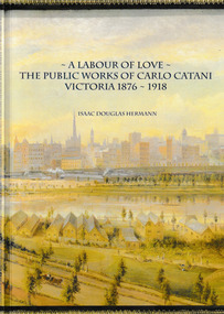
Book, Isaac Douglas Hermann, A Labour of Love The Public works of Carlo Catani Victoria 1876 - 1918, October 2021
The book covers all the Victorian Public Works projects of Carlo CATANI including the Catani Memorial Clock Tower & the Catani Gardens in St Kilda. Book, 'A Labour of love - the Public Works of Carlo Catani Victoria 1876 - 1918'. The front & back covers are from a 1905 painting by Laurence WILSON showing the southern approach to Melbourne and with Princes Bridge and the Yarra River.carlo catani, carlo catani memorial clock tower, catani gardens -
 Bendigo Historical Society Inc.
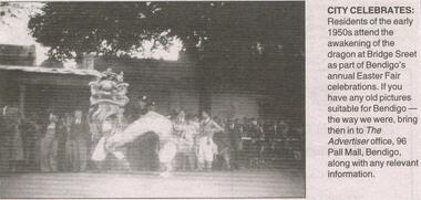
Newspaper - JENNY FOLEY COLLECTION: CITY CELEBRATES
Bendigo Advertiser "The way we were" from Monday, March 14, 2005. City celebrates: residents of the early 1950s attend the awakening of the dragon at Bridge Street as part of Bendigo's annual Easter Fair celebrations.newspaper, bendigo advertiser, the way we were