Showing 8648 items matching "bridge-spike"
-
 Eltham District Historical Society Inc
Photograph, Looking southeast near 80 Bible Street, Eltham, c.September 1966, 1966c
The end of the stone wall is the border between 78 and 80 and the extension of the stonewall is distinctly visible todayBlack and white photographic printIlford paper stamped 8963 Originally located in a Filmpro King Size Prints processing envelope $3.01 Shire of Eltham 9/9/66 and noted as Calrossie Ave area and crossed out Eltham-Yarra Glen Road, Bridge Street to Elsa Court existing conditions mid 1967bible street, road construction, streets -
 Federation University Art Collection
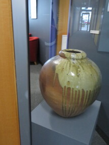
Ceramic - Artwork - Ceramic, 'Wood Fired Urn' by Robert Barron
Robert BARRON (1957- ) Born in Harpenden, England. Robert Barron first worked full-time with clay in 1976, the family pottery at Croydon, Victoria. In 1979, he left Australia on a five-year journey to New Zealand, North America, England, Europe, and South Korea to work with skilled potters in woodfiring. During this time, he visited Michael Cardew at Wenford Bridge Pottery, Cornwall, UK., and was engaged as an apprentice at Cornwall Bridge Pottery, Connecticut, USA. Returning to Australia in 1984, he established Gooseneck Pottery at Kardella, Victoria. With the assistance of a Crafts Board grant Robert Barron built a 1000 cubic ft five-chambered Nabori-Gama style woodfired kiln. This kiln one of the largest wood-fired kilns in Australia. Robert Barron is influenced by the philosophies of Bernard Leach and Michael Cardew.artwork, artist, ceramic, gippsland campus, robert barron -
 Linton and District Historical Society Inc
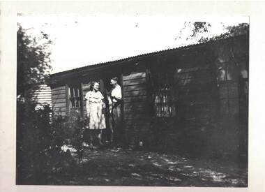
Photograph, Joe Reidy and Stella Pearse, undated
The house is identified in the early LDHS index to photographs as being "Joe and Stella Reidy's home on Geelong Road" (Geelong Road now called Linton-Naringhil Road). Joe Reidy and Stella Pearse married in 1938. Information provided in 2025: "Joe and Stella out the back of their house. It has a flat roof on the back verandah and a normal peaked roof on the house. The house is on Naringhil Rd opposite side of road to Linton Park and back towards Linton. It used to have a foot bridge over the small creek, but now it has a pipe and driveway. At the back of the house is an old dairy where Joe would milk the cows morning and night after working the day for the Shire. The small foot bridge had decorative pine cones along it. Lovely garden etc. Joe was also Captain of the fire brigade for a long time." Enlarged black and white copy of original photograph, which has been mounted on white card. The photograph shows a young woman and young man standing outside a timber cottage. On card attached to bottom of photograph: "Joe Reidy and Stella Pearse (Mick Chung was born in this house.)"joe reidy, stella reidy nee pearse -
 Ballarat Tramway Museum
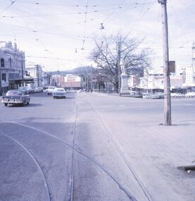
Slide - 27 mm sq slide/s - set of 8 - tram tracks - Victoria St, Lilian Butler, Aug. 1971
Yields information about the streetscapes of Ballarat on the Gardens to Victoria St route and in particular buildings and people that crewed the trams.Set of eight Colour 27 x 27 mm slide in a Kodachrome cardboard mount. .1 - view of the Sturt and Lydiard St intersection from the front of the tram car with the Robbie Burns statue in the view and the Big W store. .2 - ditto at the corner of Sturt and Grenville St with the tramway shelter and the Dickins store. .3 - setting the signals for the Bridge St route. .4 - View looking east along Bridge St with Big W store and Faull's shoe shop. .5 - At intersection with Main Road, looking up the hill towards Victoria St. On the right is the advert for Viscount Ambassador Caravans. .6 - Looking along Victoria St, towards the East at E St, with the biscuit factory on the left. .7 - tram shelter at Queen St. .8 - View of the terminus looking east, showing the median strip Slide mount date August 1971. Photo from the collection of Lilian Butler.ballarat, tramways, trams, sturt st, grenville st, shelters, bridge st, signals, victoria st -
 Kew Historical Society Inc
Plan - Subdivision Plan, Oswinia Estate, East Kew, c.1925
Prue Sanderson, in her groundbreaking ‘City of Kew Urban Conservation Study : Volume 2 - Development History’ (1988), summarised the periods of urban development and subdivisions of land in Kew. The periods that she identified included 1845-1880, 1880-1893, 1893-1921, 1921-1933, 1933-1943, and Post-War Development. These periods were selected as they represented periods of rapid growth or decline in urban development. An obvious starting point for Sanderson’s groupings involved population growth and the associated economic cycles. These cycles also highlighted urban expansion onto land that was predominantly rural, although in other cases it represented the decline and breakup of large estates. A number of the plans in the Kew Historical Society’s collection can also be found in other collections, such as those of the State Library of Victoria and the Boroondara Library Service. A number are however unique to the collection.Subdivision plans are historically important documents used as evidence of the growth of suburbs in Australia. They frequently provide information about when the land was sold on which a built structure was subsequently constructed as well as evidence relating to surveyors and real estate and financial agents. The numerous subdivision plans in the Kew Historical Society's collection represent working documents, ranging from the initial sketches made in planning a subdivision to printed plans on which auctioneers or agents listed the prices for which individual lots were sold. In a number of cases, the reverse of a subdivision plan in the collection includes a photograph of a house that was also for sale by the agent. These photographs provide significant heritage information relating house design and decoration, fencing and household gardens.The ‘Oswinia Estate’ subdivision in East Kew was planned and auctioned in the first half of the 1920s. 169 allotments were created in the triangular section of land bordered by High Street, Burke Road and the Government Boulevard (later Kilby Road). The only piece of land excluded was that where the previous Kew Pound had been located at the east tip of the triangle. Allotments were created fronting Glass, High, Namur, Oswin Streets, Irymple Avenue, and the Government Boulevard. The name for the Estate was derived from Oswin’s farm, which had been one of the largest landholdings in East Kew. The selling agents annotated the plan in our collection with crosses indicating those lots that had been sold. The inset locality plan is particularly interesting as it shows the route and stations of the Outer Circle Railway. When the subdivision plan was created, it included the proposed bridge over the Yarra at Burke Road. The bridge was to be officially opened in 1926.subdivision plans - east kew, oswinia estate, high street, glass street, namur street, government boulevard - kilby road, irymple street, oswin street -
 Tarnagulla History Archive
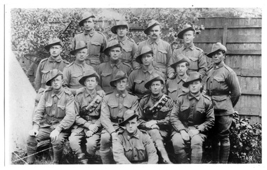
Photograph of soldiers from Tarnagulla and district, Soldiers from Tarnagulla and district, Exact date unknown, circa 1914-1918
Murray Comrie Collection.Monochrome photograph of soldiers in uniform. Subjects are residents of Tarnagulla and other towns in surrounding district. All subjects served in First World War, dating the image to circa 1914-1918. Accompanied by a note that gives the following names: (Left to Right) Back Row: 1. Jim Browbill (Simpson's Creek) 2. Geo. Whyte (Tarnagulla) 3. Ken Bramley (Arnold's Bridge) 4. Geo. Riordan (Arnold's Bridge) Third Row from front: 1. Harold Spedding 2. Hewie Spedding (Laanecoorie) 3. Jack Graham (Murphy's Creek) 4. Syd Akers (Tarnagulla) 5. Geo. Corrie (Tarnagulla) Second row from front: 1. Geo. Clark (Llanelly) 2. Allan Mitchell (Llanelly) 3. Sergt. Anderson (Laanecoorie) 4. Jack Mitchell (Llanelly) 5. Will Kilgour (Tarnagulla) Front Row: 1. Fred Jackson (Tarnagulla) Same image as THA-2019.0203, which is an original print.tarnagulla, llanelly, laanecoorie, arnold, arnold's bridge, simpson's creek, murphy's creek, war, military, service, soldiers, veterans, ww1, first world war, kilgour, jackson, clark, mitchell, anderson, spedding, graham, akers, corrie, brownbill, whyte, bramley, riordan -
 Bendigo Historical Society Inc.
Postcard - Australia, Elliot Collection, 1895 - 1914
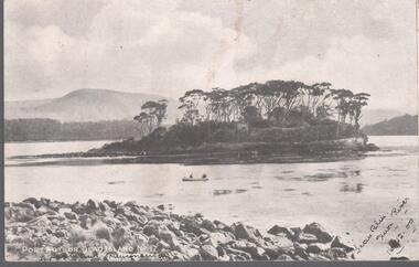
Thought to have originated in Austria in 1869, postcards first gained popularity in Australia in the 1890s.They were used to send short messages to friends and family. This collection was generated by Mary Emma Elliot of Talgarno. Talgarno is a rural locality in Victoria, Australia, situated on the southern shoreline of Lake Hume, about 23 km east of Albury-Wodonga. The collection contains postcards from across the world. Mary Emma Sibley was born in Ironbark, Bendigo in 1859. She married James Elliot in 1893 and they settled at “Kelso”, Talgarno. They had two children – Mona and Sibley. Mary Emma Elliot died in Melbourne in 1944, aged 84 years. Australian postcards collected by Mrs. James Elliot between 1898 and 1915. 1405.261 Port Arthur, Dead Island No 1 1405.262 Launceston, Crusoe Hut, Cataract Gorge 1405.263 Kathleen Sound, Gordon River, W. Coast. Tasmania 1405.264 St. Patrick's Head. East Coast. Tasmania 1405.265 Hobart 1405.266 Restless Seas, Coast of Australia 1405.267 Brown's River Road 1405.268 The Rocking Stone, Mt. Wellington 1405.269 Cataract Gorge, Launceston. Tas 1405.270 Mount Olympus. Tasmania 1405.271 Latrobe Road near Devonport 1405.272 Salmon Ponds, New Norfolk 1405.273 Launceston from Trevallyn 1405.274 Burnie, N. W. Coast. Tasmania 1405.275 River Derwent, near New Norfolk 1405.276 Botanic Gardens, Hobart, Tasmania 1405.277 "The Winter Garden" 1405.278 Hobart Waterworks 1405.279 LAUNCESTON. King's Bridge 1405.280 The Bridge. Perth (Tasmania)postcards, collecting, collections, talgarno -
 Glen Eira Historical Society
Book - Local Government Act First Report of the Assistant Commissioner of Roads and Bridges
This file contains 1 item: 1/The Local Government Act, First Report of the Assistant Commissioner of Roads and Bridges, printed by order of the Victorian Legislative Assembly on 08/03/1865. The document is the first annual report of John Steavenson, Assistant Commissioner of Roads and Bridges under s330 of the Local Government Act no. 176 (1863), and relates to transactions which took place from 02/09/1863 to 31/12/1864. The report outlines operations carried out by the Department of Roads and Bridges in this period. In the Glen Eira area this includes: separating electoral subdivisions of single districts (Moorabbin), adding detached portions of territory to road districts and shires (Caulfield), appointing of and altering in polling places, appointing of polling places for ridings of shires and subdivisions of road districts (Moorabbin), preparing and transmitting of forms of books also of pro forma accounts for guidance of local bodies in keeping their accounts, appointment of main roads, construction of a main road, ‘Dandenong’, in the Caulfield and Gardiner districts, proclaiming of Common Toll Roads, names of and security given by Managers of Common Toll Roads. The report also gives some information about the Shire of Caulfield, which contained 24 road districts and 340 rate payers in 8¼ square miles, and the Shire of Moorabbin, which contained 62 road districts and 713 rate payers in 30 square miles.local government act, assistant commissioner of roads and bridges, legislative council, caulfield historical soceity, steavenson john, sullivan j. f. the honourable, caulfield, moorabbin, road districts, point nepean road, nepean highway, dandenong road, princes highway, brown edwin, osher joseph, cosgrove john, ferres john, roads and bridges offices, caulfield roads district, moorabbin roads district, road construction and maintenance, roads and streets, acts of parliament -
 Melbourne Tram Museum
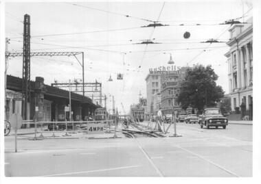
Photograph - Set of 12 - construction of King St overpass in Flinders St, 1959
Photos show the construction of King St overpass in Flinders St which was part of the project to construct a bridge over the Yarra River and provide a new southern outlet road between the city and eventually St Kilda Junction. The overpass construction was commenced in 1959 with tramway works first commencing. It was demolished in 2005. 1 - looking west at Market St. 2 - looking east from Spencer and Flinders St with the railway viaduct behind. 3 - Tram lines diverted onto the new overpass. Note the hand-powered overhead tower on the left behind the compressor. 4 - Tracks partially diverted. 5 - Looking east at Spencer and Flinders St with a Dunlop tyre truck in the view. 6 - prior to the diversion onto the new bridge. 7 - Looking east near William St. with W2 451 (Route 48, North Balwyn) in the view. 8 - Bridge works near King St. Original tracks still in use. 9 - Looking east prior to the introduction of the temporary tracks on the south side of the new overpass. 10 - SW6 852 and a W2 on new overpass trackwork - old trackwork being demolished. 11 - Cross over at Spencer St in Flinders St, prior to change over. 12 - Looking west at Flinders and Spencer St with SW6 853 turning into Spencer St.Yields information about the construction of the King St overpass in Flinders St during 1959.Set of 12 black and white prints of the construction of the King St overpass in Flinders St.trams, tramways, flinders st, king st overpass, construction, bridges, w2 class, sw6 class, tram 451, tram 853, tram 852 -
 Eltham District Historical Society Inc
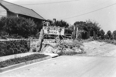
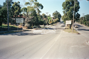
Negative - Photograph, Main Road, Eltham, c.Dec. 1983
Road sign advising of proposed reconstruction works of Main Road to install a roundabout at Mount Pleasant Road. Traffic to Lower Plenty and Templestowe to be diverted down Bridge Street (and Bolton Street) effective January 1984. The proposed roundabout did not proceed. Instead traffic islands on Mount Pleasant Road were installed in place of temporary blocked out islands.Film - Kodak CM 400 5079 7 strips, 26 framesinfrastructure, roads, road construction, roundabout, road sign, main road, mount pleasant road -
 Greensborough Historical Society
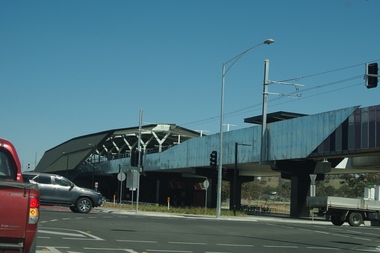
Photograph - Digital Image, Marilyn Smith, Mernda Station 2018, 27/09/2018
In 2018 GHS members visited Turner's Bakery in Mernda for lunch and continued on to visit historic sites remaining in the Mernda area. This photograph shows the newly built Mernda Station, part of the railway extension on the old Epping line. This station was opened in August 2018. Mernda is now the end of the line. It is sited on corner Bridge Inn Road and Schotters Road. Mernda is an area of rapid modern growth with a few remaining historic buildings dating from the 19th century.Digital copy of colour photographmernda, mernda historic sites, schotters road mernda, mernda station, bridge inn road mernda -
 Halls Gap & Grampians Historical Society
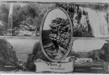
Photograph - B/W, C 1930s
The four scenes are 1) Venus Baths [top left],2) Mackenzie Falls[top right],3) The Grand Canyon[bottom left],4)Bridge and Road at Halls Gap[bottom right]. A centre view in an oval frame is The Pinnacle and a scroll with 'Views of the Grampians' written on it appearing below the frame. A scrolled frame runs top and bottom of the four scenes.Photo is a copy of a postcard, depicting four scenes in the Wonderland Range.scenery, grampians ranges -
 Eltham District Historical Society Inc
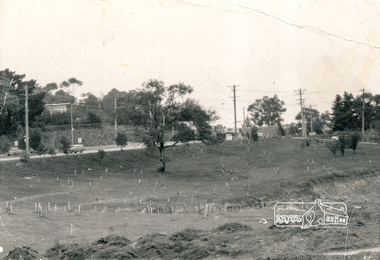
Photograph, Alistair Knox Park, Eltham, c.1970, 1970c
View from northwest corner showing survey pegs for trees and two ponds. Main Road has been duplicated. Bridge Street intersection showing the rock wall on the east side of the original Main Road (Maria Street). Burgoyne's Store and Eltham Uniting Church in distance at centre right and Our Lady Help of Christians at centre left.In February 1968 an unknown person took a series of photos from the Eltham Hotel at Pitt Street heading north along Main Road through the shopping centre to just north of Elsa Court covering the length of the section of Main Road which was duplicated shortly thereafter. Shows the condition and environment of the streesscape of Main Road, Eltham immediately prior to the duplication between Pitt Street and Elsa Court through the shopping centre. Also shows a number of shops and businesses that operated at that time.Black and white photographduplication, eltham, main road, bridge street, burgoyne's shop, eltham uniting church, our ladys church, maria street -
 Eltham District Historical Society Inc
Newsletter, Newsletter, No. 198 May 2011
Contents: • Next meeting, guest speaker; Ross McDonald and Bruce Draper: The McDonalds and the Drapers; two significant Nillumbik families • May Meeting • Eltham Lower Park Walk • Eltham Railway Line • Eltham North Bridge • Room Names at Our Local History Centre • Nillumbik Heritage Strategy • Subscriptions • Office Bearers 2011-2012 • And Also The Shire of Eltham Historical Society was formed in October 1967. The first newsletter of the Society was issued May 1978 and has been published continuously ever since on a bi-monthly basis. With the cessation of the Shire of Eltham in late 1994, the Society's name was revised to Eltham District Historical Society and this name first appeared with issue No. 103, July 1995. The collection of the Society's newsletters provides a valuable resource on the history of the Society's activities, office bearers and committee members, guest speakers and subjects of historical interest pertinent to the former Shire of Eltham and the Eltham District.A4 photocopied newsletter distributed to membersnewsletter, eltham district historical society, shire of eltham historical society -
 Nillumbik Shire Council
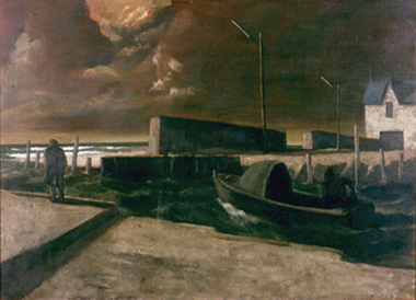
Painting: Rick AMOR (b.1948, Melb. AUS), Rick Amor, Out to Sea, 1993
Rick Amor was a good friend of three times Archibald Prize winner Clifton Pugh, living and working at Pugh's artist colony Dunmoochin, (Cottles Bridge) during the 1980-1990s. Amor made frequent outdoor painting trips with Pugh. His studies of Williamstown and areas around the port fuelled a period of sustained painting in his studio at Dunmoochin. Amor is an artist of national significance who had lived locally in Dunmoochin (Cottles Bridge) during the time of this work's making. This painting was exhibited/entered into the 1993 Shire of Eltham Art Awards. The work is representative of Amor's style and interest in seascapes as subject matter. Oil on linen, seascape painting. A solitary and motionless male figure in an overcoat stands at the edge of a dock/jetty with his hands in his pockets looking out to sea with his back towards the viewer. A motorised boat is moored close by and a white house with a blue roof can be seen in the distance. The figure is engulfed by the landscape and a resounding sense of desolation. A storm is brewing; the mood forecast by dark, heavy and thick ominous clouds, alternately darkening with the approach of night, a polluted haze and rough seas. In red paint, lower right, signed 'RICK AMOR '93'amor, seascape, painting, personal, boat, dramatic, atmospheric, ekphrasis 2015, dunmoochin -
 Stawell Historical Society Inc
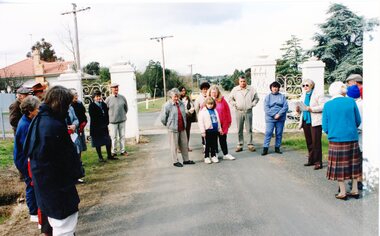
Photograph, Cemetery Crowd
7083. A Groupd of People standing inside the Cemetery Gates Stawell. 7083-1 A Group of people looking at a fenced headstone 7083-2 A Group of people looking at a Monument. With houses in the background. 7083-3 A Group of People lookning at graves. 7083-4 A Group of People on a dirt road over a small bridge, with a white ute in right foreground.5 Colour Photographs: showing a group of people at various locations looking at Graves, Monuments and a bush land site. -
 Stawell Historical Society Inc
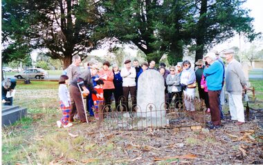
Photograph, Grave Headstone
7083: A Group of People Standing inside the cemetery Gates. Stawell 7083-1 A group of people looking at a headstone. 7083-2 A Group of people looking at a monument with houses in the background. 7083-3 A Group of people looking at graves 7073-4 A Group of People on a dirt road over a small bridge with a white ute in teh right foreground.5 colour Photographs: showing a group of people at various locations looking at graves, Monuments and a bushland setting. -
Stawell Historical Society Inc
Photograph, Grave Headstone
7083: A Group of People Standing inside the cemetery Gates. Stawell 7083-1 A group of people looking at a headstone. 7083-2 A Group of people looking at a monument with houses in the background. 7083-3 A Group of people looking at graves 7073-4 A Group of People on a dirt road over a small bridge with a white ute in teh right foreground.5 colour Photographs: showing a group of people at various locations looking at graves, Monuments and a bushland setting. -
 Stawell Historical Society Inc
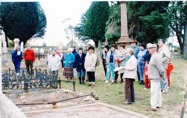
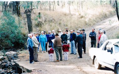
Photograph, Group of Stawell Historical Society members at Old Cemetery at One Tree Hill
7083: A Group of People standing inside the cemetery Gates. Stawell 7083-1: A Group of People looking at a fenced headstone 7083-2 A Group of people looking at a Monument with houses in background 7083-3 A groupd of people looking at graves 7083-4 A Group of people on a dirt road over a small bridge with a white ute in right foreground.5 Colour Photographs: showing a group of people at various locations lookning at graves, Monuments and a bushland setting. -
 Stawell Historical Society Inc
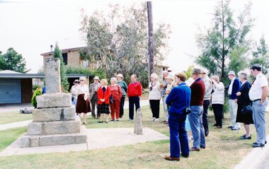
Photograph, Looking at a Monument
7083: A Group of People standing inside the cemetery Gates. Stawell 7083-1: A Group of People looking at a fenced headstone 7083-2 A Group of people looking at a Monument with houses in background 7083-3 A groupd of people looking at graves 7083-4 A Group of people on a dirt road over a small bridge with a white ute in right foreground.5 Colour Photographs: showing a group of people at various locations lookning at graves, Monuments and a bushland setting. -
 Stawell Historical Society Inc
Photograph, Looking at a Monument
7083: A Group of People standing inside the cemetery Gates. Stawell 7083-1: A Group of People looking at a fenced headstone 7083-2 A Group of people looking at a Monument with houses in background 7083-3 A groupd of people looking at graves 7083-4 A Group of people on a dirt road over a small bridge with a white ute in right foreground.5 Colour Photographs: showing a group of people at various locations lookning at graves, Monuments and a bushland setting. -
 Melbourne Tram Museum
Postcard, Valentine's, "Swanston Street, Melbourne", 1930s
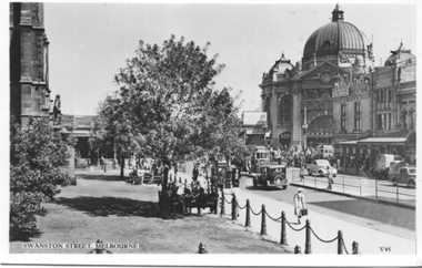
Valentine's postcard titled "Swanston Street, Melbourne", Number V45, looking south from the yard at St Paul's Cathedral to Flinders St Station. There is a W2 Class tram at both the southbound tram stop in Swanston St and one in Flinders St. In the background is St Paul's Cathedral, Princes Bridge station, Flinders St station, and Young and Jackson Hotel, Yields information about Swanston Street during the 1930s.Postcard - printed, unused, Valentine Seriestrams, tramways, swanston st, princes bridge station, flinders street, w2 class -
 Melbourne Tram Museum
Pamphlet, Yarra Trams, Tram Service Changes, 2022
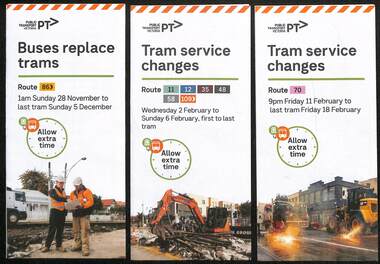
.1 - pamphlet provided at tram stops giving details of the works and bus services for 86 - Merri Creek Bridge works .2 - ditto - for provision of a super stop in William St at Collins St including replacement bus services on route 58 .3 - as for .1 - track reconstruction in Swan St between Stanley St and Stawell St Richmond or BurnleyShows the methods that Yarra Trams customers are advised of changes due to track replacement works..1 - Pamphlet - DL, three fold DL - Buses replace trams - route 86 - 28/11/2021 to 5 December 2021 - Route 86 .2 - Pamphlet - DL, four fold DL - Tram Service changes 2/2/2022 to 6/2/2022 - Routes 11, 12, 35, 48, 58 and 109 .3 - Pamphlet - DL, four fold DL - Tram Service changes - 11/2022 to 18/2/2022 - Route 70tram works, track work, route 58, yarra trams, ptv, route 86, merri creek, bridges, super stops, trams, tramways, richmond, burnley, route 70, collins st, william st -
 Melbourne Tram Museum
Photograph - Colour print - City Circle tram - Docklands, Jan. 2003
Colour print showing a City Circle car fitted with trolley poles on the City Circle route in Harbour Esplanade with the Collins St bridge and Queens Warehouse in the background. This building now houses the Fox Classic car museum. Given the flagging on either side of the road, photo is probably soon after the opening of the section of the City Circle route in Jan. 2003.Yields information about the Melbourne City Circle tram route.Colour print on paper - Kodak Professional Papertrams, tramways, city circle, harbour esplanade, docklands melbourne -
 Melbourne Tram Museum
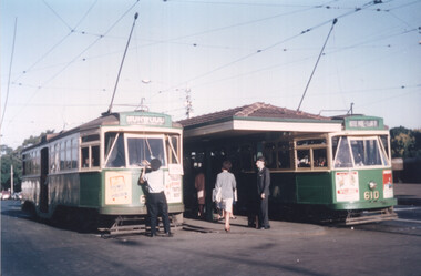
Photograph - Colour print - Y1 class trams - Batman Ave
Colour print showing two Y1 class trams at the Batman Ave terminus at Princes Bridge. The tram on the left has the destination of Burwood, with the driver attending to the pole. The tram on the right, Y1 610 has the destination of Wattle Park Elgar Road. Both these trams were based at Camberwell Depot during the 1960s and 1970s. Photo likely mid-1960s. Yields information about the use of the Y1 class trams during the 1960s.Colour print - printed on Kodak Royal paper.trams, tramways, batman ave, y1 class, tram 610, mmtb, route 70, wattle park -
 Melbourne Tram Museum
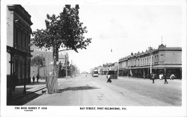
Postcard, Rose Stereograph Co, "Bay Street Port Melbourne", c1925
Rose Series postcard No. P 3334 titled "Bay Street Port Melbourne", looking south from near Bridge Street. Has two cable cars in the view, the northbound one has the destination of "Spring St". Has a Theatre on the left side of the photo along with a "Hail cars Here" tram stop sign on a pole. Photo c1920.Yields information about Bay St Port Melbourne. C1920Postcard - printed real photograph with Rose Stereograph Co. name on the rear.Has the stamp of Ken Magor on the rear.trams, tramways, cable trams, bay st, port melbourne -
 Eltham District Historical Society Inc
Photo Album, David Taylor, Photo Album; David Taylor, c.1976
Contains relevant images from Eltham and surrounds taken during the mid 1970s. Subjects include Peter Garner and his mudbrick studio in Brougham Street, Brougham Street Bridge, Eltham High School surrounds, Dalton Street lane and footbridge (present-day Wingrove Park Trail), Fabbro's farm and Christmas Hills Festival c.1976brougham street bridge, christmas hills festival, dalton street lane, david taylor collection, eltham high school, fabbro's farm, peter garner, peter garner adobe studio, wingrove park trail -
 Ballarat Tramway Museum
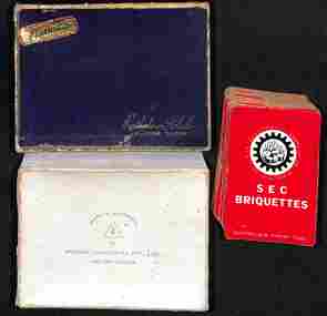
Leisure object - Playing cards - SEC Briquettes, Hudson Industries Pty Ltd, 1950s
Pack of playing cards, complete with Joker and a card advising the International Contract Bridge score system. Advertises SEC Briquettes, "Australia's finest fuel" and has the SECV full name around a logo on the card. Understood there was also a blue-backed set of cards. Box marked "Rathdown Club playing cards", printed by Hudson Industries of Carlton Vic.Demonstrates a SEC souvenir advertising Briquettes.Pack of playing cards within a cardboard box.playing cards, secv, briquettes -
 Phillip Island and District Historical Society Inc.
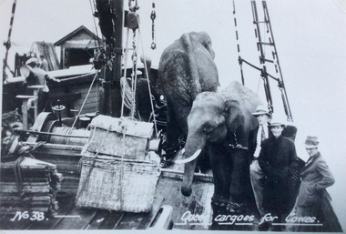
Photograph, Narrabeen ferry with cargo of elephants
The elephants pictured here were from Perry Brothers Circus Zoo, and came over on the ferry, Narrabeen, somewhere between 1928 and 1932. Before the Phillip Island San Remo bridge was built, there was only one way to get the circus to town, and that was on the ferry. Part of a collection of 'Rose & Valentine' series of Post Cards. Copied by John Jansson 1984B&W postcard. On board the Ferry "Narrabeen" showing passengers beside an unusual cargo of elephants, bound for Cowes.Queer cargoes for Coweslocal history, photography, photographs, postcards, ferries, shipping, - transport, black & white postcard copy, cowes, phillip island, narrabeen, elephants -
 Bendigo Military Museum
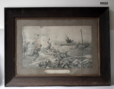
Print - PEN & INK PRINT, FRAMED, Walsh's Portrait Printers and Enlargers, "Saving Amiens", c1918-1930
The owner was John Conrad Brown NR 706 of the 38 Bn. He was severely wounded in action (GSW to face and left arm). He returned to Australia and was pensioned off. The owner had this artwork in his house at Goornong until a storm blew the roof off. It was important to him.This is a large black and white print depicting a scene in the Amiens battle. It shows Australian and German men fighting. A small stone bridge is near the centre of the work. High explosive blasts are depicted in the picture. It is finely detailed i.e. buttons on uniforms and dovetail joints in the ammunition box. It is set in a thick card mat. Under the image is the caption. The frame is a simple heavy timber type. The rear has a paper cover but is broken away.The artist was F. Matania. (Fortunino Matania)ww1, amiens, 9 brigade, framed print