Showing 10880 items
matching land
-
 Orbost & District Historical Society
black and white photograph, 1937
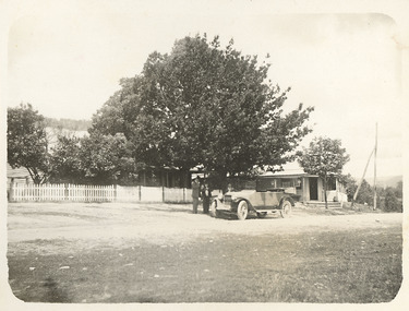
In 1912 the school at Pumpkin Point opened to serve the children of farmers living in the Bete Bolong district. This meant a big change in their way of life because in the past the children had been rowed across the Snowy River each day to attend school at Jarrahmond. Myrtle Bunting was the first HT of the school which had been erected on a block of land purchased from H. Richardson. The school functioned until 1952 when a shortage of pupils caused its closure. As a bus service to Orbost now operated, the school at Pumpkin Point faced permanent closure. J. McKeown bought the building.This item is associated with the history of education in the Orbost districtA small black / white photograph of students from the Bete Bolong State School at the District Sports.on back - S.S. Bete Bolongeducation-orbost bete-bolong-state-school -
 Marysville & District Historical Society
Photograph (Item) - Black and white photograph, Unknown
A digital copy of a black and white photograph of the Buxton Hotel in Buxton. The Buxton Hotel was built by William Burchall, probably in the late 1870s. The first owner, who also had land locally, was Frederick Nichols (1833-1904). The Buxton Hotel is located directly opposite the General Store. It was fronted with two huge oak trees and bordered and backed by large pine trees. It was a weatherboard structure with a painted corrugated iron roof. Old split wood shingles were covered by corrugated iron, which overlaid the shingles to make the roof watertight. The wooden shingles date back to the 1850s.A digital copy of a black and white photograph of the Buxton Hotel in Buxton.buxton, victoria, australia, buxton hotel, photograph, william burchall, frederick nichols -
 Marysville & District Historical Society
Photograph (Item) - Black and white photograph, Mark James Daniel, 1904
A digital copy of a black and white photograph of Nichol's Buxton Hotel in Buxton. The Nichol's Buxton Hotel was built by William Burchall, probably in the late 1870s. The first owner, who also had land locally, was Frederick Nichols (1833-1904). The Buxton Hotel is located directly opposite the General Store. It was fronted with two huge oak trees and bordered and backed by large pine trees. It was a weatherboard structure with a painted corrugated iron roof. Old split wood shingles were covered by corrugated iron, which overlaid the shingles to make the roof watertight. The wooden shingles date back to the 1850s.A digital copy of a black and white photograph of Nichol's Buxton Hotel in Buxton.buxton, victoria, australia, buxton hotel, nichol's buxton hotel, photograph, william burchall, frederick nichols -
 Federation University Historical Collection
Photograph - Photograph - Black and White, Ballarat Civic Hall, c1965
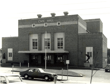
The City of Ballarat unanimously resolved to erect a Civic Hall in 1951. The architects, Gordon Murphy, of Melbourne, and H.L. and L.J. Colburn, of Ballarat, were commissioned in 1952. The Council constructed the foundations and footings for the building under the supervision of the former City engineer, Mr L.H. Finch, in 1953. These footings are of massed concrete. The design for the building took advantage of the cross fall of the land, providing for the Small Hall to be entered from the Doveton Street frontage through a foyer under the Main Stage, the structure is steel with brick panels, with accommodation for 1,592 persons in the Main Hall and 440 persons in the Lower Hall. Black and white photograph of a brick building known as Ballarat Civic Hall. It is located on the corner of Mair Street and Doveton Street North. The Shakespeare statue out the front of the building was unveiled on 17 November 1960. ballarat civic hall, civic hall, colburn, finch -
 City of Moorabbin Historical Society (Operating the Box Cottage Museum)
Photograph, B&W, George William Box & Elizabeth Honor Tippett Wedding 1902, c1902
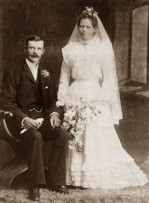
Box Cottage Museum, a reconstruction of an early settler hut, is named after the Box family who resided there 1865 -1913 . George William Box 1870 -1933 was a son, and twin brother of Cecilia Eliza, of William and Elizabeth Avis Box who lived in Box Cottage and farmed the land 1865 - 1913 . George William Box married Elizabeth Honor Tippett 1902 and they had 8 children. Elizabeth Avis Box gave them a shop with a dwelling in Jasper Road where Elizabeth Honor sold groceries and vegetables while George obtained various jobs. Box Cottage Museum, a reconstruction of an early settler hut, is named after the Box family who resided there 1865 -1913 . George Box was the father of William Box who with his wife Elizabeth Avis Box and 13 children lived and farmed on the block of land in Jasper Road, East Brighton ( now McKinnon / Ormond) that was part of the Henry Dendy Special Survey 1841 Inscribed inside Album : “ The early photos in this album were found by Mr (Laurie) Lewis when he was demolishing the Old Box Cottage. He gave them to Mrs Avis Box Eldridge who in turn gave them to me. They were not identified. I believe they rightly belong in the Cottage. I have attempted to identify them and present them in a way they can be preserved as a historical record of the era.” A B Leigh A black & white Wedding photograph 1902 of George William Box 1870-1933 and Elizabeth Honor Tippet Box d1953TALMA 119 Swanston Street / Melbourne / and at Sydneybox george, box mary, box william, box elizabeth, box alonzo, box mary louisa, dendy henry, were j b, dendy's special survey 1841, brighton, moorabbin, bentleigh, mckinnon, ormond, market gardeners, dairy farms, early settlers, pioneers, jasper road, gurr jabez, gurr eliza, pay henry, pay anna, ward willam, box henry, ward elizabeth emma, box john, sheldrake martha, rushall eleanor, box caroline, box william, box elizabeth avis -
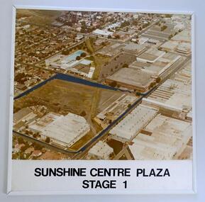 Sunshine and District Historical Society Incorporated
Photograph (1982) - Part Sunshine Business Area, Sunshine Centre Plaza Stage 1, 1982
The Sunshine business area has undergone major change from industrial manufacturing to retail. This aerial photograph shows the industrial areas that existed on both sides of Hampshire Road in 1982, and which have since been replaced by two shopping centres and the library building. The photograph also shows the old swimming pool, and retail outlets that no longer exist such as Waltons, Clark Rubber, Fosseys and the original Safeway store. It also shows a vacant land where the current Centrelink office now exists. The photograph was originally used as a promotion for the Sunshine Centre Plaza retail complex.This photograph is a historical record of what part of Sunshine looked like 3 decades ago.Large cardboard mounted sepia photograph with thin white plastic edging. Grey painted outline shows the site in 1982 on which the SUNSHINE CENTRE PLAZA was to be built, as well the buildings that then existed in part of the business area of Sunshine.Sunshine Centre Plaza Stage 1aerial view, 1982, sunshine centre plaza, sunshine business area, massey ferguson buildings, old sunshine pool. waltons -
 Whitehorse Historical Society Inc.
Photograph, Mitcham Primary School No 2904
On 24th September 1888 a wooden state school opened on land purchased on the north west corner of Whitehorse and Mitcham Roads. In 1890 a contract was let for the construction of a one-room brick school house on that site. By 1907 student numbers had risen to 120 so the Church of Christ Hall was leased for 10/- a week. By 1922 cracks had appeared, plaster had fallen in the school and both the Brittania Street Scout Hall and the Methodist Church has been leased for classrooms. On 10/4/1930, a new school, to be occupied by the upper grades was opened in its present location.Coloured picture of Mitcham Primary School No 2904 The traffic lights are at the intersection of Mitcham and Doncaster East Roads - 2012mitcham primary school no. 2904, schools -
 Hume City Civic Collection
Photograph, Lois Alexander, Goonawarra Winery, 1986
It is a photograph of Goonawarra Winery that was first established by James Goodall Francis, who in 1863 applied to lease 26 acres of land on the condition that he plant vines on some of it. The property continued to be worked as a vineyard by him and his son, Wilfred, until the late 1920s when wool and mutton were production were preferred to wine production and the vines were pulled out. The Carmody family purchased purchased the property in 1961 and used it for grazing until 1976, when they replanted vines there. In the early 1980s, John and Elizabeth Barnier purchased the property and continued to run the property as a vineyard.Goonawarra is one of the earliest vineyards and wineries to be established in Sunbury. A non-digital coloured photograph of a large winery building.goonawarra vineyard, john barnier, elizabeth barnier, james goodall francis, sunbury road, vineyards., winery -
 Ballarat and District Irish Association
Photograph - Colour, Clare Gervasoni, Crossley near 'Hillside" McCartney's Lane, 2014, 04/04/2014
Before 1941 "Hillside", McCartney's Road was associated with the Carroll Family. Patrick Edmund Carroll, his wife Mary Matilda Fitzgerald, and children Kathleen, Ronald and Rosemary were the last members of the family to live at and work "Hillside". Stanislaus Kelly and his wife Margaret (nee Gorman) bought the farm from the Carroll family. The couple raised six children on the land: May, Mary, Leo, Ray (Lofty), Daniel (Tich) and Bernadette. The family grew spuds and onions on the hill and milked cows, with the little dairy located on the eastern side of the house. (information from Mary Kelly)Colour digital photographs of Crossley, Victoria, near McCartney's Lane. The house depicted is "Hillside" in McCartney's Lane. The views towards an extinct volcano is Tower Hill.crossley, hillside, carroll, tower hill, mccartney's lane -
 Mt Dandenong & District Historical Society Inc.
Photograph
The Wenborn family acquired Ferguson's Lot 19 of the Village Settlement where the original Mount Dandenong School was opened in a shed. WH Collom owned the land after Ferguson and then it passes to the Wenborns. This photograph shows Jim Wenborn with his wife Ivy and daughter Mary. The Wenborns had another daughter, Joan. Both children attended Mt Dandenong State School. John Lundy-Clarke grew up in the Kalorama/Mt Dandenong area and later in life (1972-74) began to write a comprehensive history of the area working from an original settlement map in an effort to cover all areas.Black and white photograph showing a man and woman seated in a garden. The woman is holding a small baby. Handwritten inscription on reverse by John Lundy-ClarkeJim Wenborn and family.wenborn, jim wenborn, ivy wenborn, mary wenborn, joan wenborn, ferguson, wh collom, mt dandenong school -
 Mt Dandenong & District Historical Society Inc.
Photograph, Site of Jeannie Richardson's Home 1973
John Lundy-Clarke grew up in the Kalorama/Mt Dandenong area and later in life (1972-74) began to write a comprehensive history of the area working from an original settlement map in an effort to cover all areas. It was in the clearing on the left that John William (Willie) Richardson built a home for his wife Jeanie Green. It was called Mount Calvin. Jeanie was often ill and the family left the area seeking a warmer climate. They eventually settled in Brisbane. Willie sold the home and 60 acres around it to W. Rowse. Jeanie died in 1916. The remainder of the land was sold by solicitors to cover debts. Black and white photograph showing a treed hillside with a cleared area to the left hand side. Handwritten inscription on reverse by John Lundy-ClarkeLooking towards the site of Jeannie's home from near Doughty’s Road Nov 1973. Her house was in the centre of the clearing on the left. Photo Jan 1974 JLC.mount calvin, jeannie richardson, jeanie green, john william richardson, willie richardson, jeanie richardson, rowse -
 Ballarat Tramway Museum
Map, Electric Supply Co. of Vic (ESCo), Ballarat Electoral Map - ESCo, 1900
Document prepared by the Electric Supply Co of Victoria, as part of an order under the Electric Light and Power Act 1896, section 5 of order No. 17 granted to company. Dated 19/2/1901 and signed by the Postmaster-General. Shows the order area being parts of the City of Ballaarat, Sebastopol and Ballarat East. Shows the street names, boundaries, principal power line routes, land reserves, parks, mine locations, railways and Lake Wendouree. Signed by R L Williams Town Clerk City of Ballarat, J R Hall for the Borough of Sebastopol, and John Gent for the Town of Ballarat EastYields information about the power supply to the Ballarat area.Cloth backed paper map, coloured and marked up as exhibit 17.Notes in ink including the signature of Benjamin Deakin 24/9/00 and certified by the three involved municipal Town Clerks.ballarat power supply, esco, electric supply co of victoria, city of ballaarat, east ballarat, sebastopol, orders, power lines, power supply -
 Bendigo Historical Society Inc.
Book - 1859 Almanac
Richard Walter, butcher, operated a butchery in Bridge St., Bendigo. The shop was part of the Australian Hotel. It was operating in 1857 when Walter advertised for a sausage maker. In 1863 the business was sold to Ceber and Robertson. At this time he sold five lots including, land at California Gully, 32 acres at Ellesmere, the Australia Hotel including a coopers, chemist and stables all leased to reliable tenants. In 1865 he was granted 50 square miles south of Charleville, near Murweh on the Warrego River. It was here that he died 24/8/1869 when he accidentally fell into the river and drowned.Small notebook (initial pages have been removed) with 1859 Almanac on internal covers. Ledger style notebook with gold lettering on cover "R. Walter, Butcher, Bridge Stret, Sandhurst"butcher, bridge stret, sandhurst", walter -
 Ballarat Tramway Museum
Pamphlet - Real Estate, T M Burke Pty Ltd, "Tram Extensions Authorised", 1936
Wal Jack collected tramway and railway items for his collection. This pamphlet gives details of the Melbourne Public Transport system - rail, tram and bus in late 1936. Issued by T M Burke Pty Ltd of 840 Collins St Melbourne, Real Estate agents, shows the extensive sub-divisions where land was available for purchase and notes the MMTB authorisation of new tram routes. Gives details of the T M Burke services. Routes shown as authorised (16-7-1936) are: Keilor Road Essendon, High St North Balwyn and Hawthorn Road East Brighton. Demonstrates a Real Estate Sales pamphlet.Pamphlet - four colours printed on cream coloured bond paper, folded vertically originally.letter, wal jack, buninyong, railway lines -
 Kew Historical Society Inc
Photograph - Cosy Five Roomed Rough Cast Bungalow, Kew, J E Barnes, c.1920
Subdivision plans are historically important documents used as evidence of the growth of suburbs in Australia. They frequently provide information about when the land was sold on which a built structure was subsequently constructed as well as evidence relating to surveyors and real estate and financial agents. The numerous subdivision plans in the Kew Historical Society's collection represent working documents, ranging from the initial sketches made in planning a subdivision to printed plans on which auctioneers or agents listed the prices for which individual lots were sold. In a number of cases, the reverse of a subdivision plan in the collection includes a photograph of a house that was also for sale by the agent. These photographs provide significant heritage information relating house design and decoration, fencing and household gardens. The photograph is also aesthetically significant as it was taken by J. E. Barnes, a nationally significant photographer. He was the most important photographer to have worked in Kew. He was active as a photographer in the district from c.1906 until his death in 1921. Best known as 'the Embarkation Photographer' (see the Australian War Memorial collection), Josiah Earl Barnes was also the official photographer employed by the Borough (and later Town, then City) of Kew. He clearly also completed commercial jobs for local businesses, as is the case in this photograph of a house for a local real estate and financial agent. A modest weatherboard house with rough-cast rendered walls. The gabled entrance incorporates elements of the Japanese aesthetic. The strong lines of the dark timber gable are reinforced by the colour and shape of the pickets in the fence. In contrast to an earlier period, the chimneys appear truncated. The use of extensive double-hung sash windows in the front rooms reflects a new interest in light in houses. The use of separate sunshades over windows in an earlier period is here replaced by an extension of the roofline over the window. The photographer Josiah Barnes died in 1921; so, the photograph of the house must predate this date. The location of the house, which was advertised for sale, has to date not been identified. Illegible inscription. Photographer's information on mount.josiah earl barnes, j e barnes, photography - kew, interwar housing - victoria, 1920s housing - kew -
 Kew Historical Society Inc
Photograph - 2 Young Street, Kew, Paramount Photos, 1920s
Subdivision plans are historically important documents used as evidence of the growth of suburbs in Australia. They frequently provide information about when the land was sold on which a built structure was subsequently constructed as well as evidence relating to surveyors and real estate and financial agents. The numerous subdivision plans in the Kew Historical Society's collection represent working documents, ranging from the initial sketches made in planning a subdivision to printed plans on which auctioneers or agents listed the prices for which individual lots were sold. In a number of cases, the reverse of a subdivision plan in the collection includes a photograph of a house that was also for sale by the agent. These photographs provide significant heritage information relating house design and decoration, fencing and household gardens.A prepossessing, large home constructed in the Arts and Crafts style. Located on the banks of the Yarra at 2 Young Street, Kew overlooking the factories of Richmond, the design of the house takes account of the gradient with the addition of a level below the front entrance. The elegant roof includes a number of projecting gables and dormers. The gables are typically half-timbered and rendered. In addition to the asymmetrically placed portico, there are at least two open verandas, supported by timber pillars and with roofs that reflect the overall pitch of the roof of the housereal estate photographs, 2 young street - kew -
 Surrey Hills Historical Society Collection
Photograph, Mrs Caroline de Graaf
Mrs Caroline de Graaf photographed in 1929. Caroline and James de Graaf were married in 1885 and came to live in Surrey Hills. They had two blocks of land at 13 Charles Street. At first James rode his bicycle to his work in Richmond and each week Caroline would walk to Richmond carrying her baby to see her parents. They would put their shopping on the bike and walk home in the evening. Eventually train schedules suited them and they were relieved to be able to use the train for the trip. James later became employed in the timber trade in Box Hill. A black and white photograph of a lady seated on the sand. She is wearing a coat and hat and carrying a bag. There is another bag on the sand beside her. It is possibly a camera bag.(mrs) caroline de graaf, (mr) james de graaf, charles street, surrey hills, clothing and dress -
 Surrey Hills Historical Society Collection
Photograph, Trafalgar Street, Surrey Hills
This was taken to record part of the course of the former Surrey Hills Golf Club. The Surrey Hills Golf Club was founded by Mr Hugh W McLeod in 1894. The first president was Mr A W Harston. Mr William Meader was the first honorary secretary and the club champion for several years. Another notable identity was Mr. Harry Culliton, who contributed golf notes to "The Argus" for many years. As pressure for land for development grew, the club was forced to move. It eventually became the Riversdale Golf Club and its history is outlined in the book 'Riversdale Golf Club: a history 1892-1977' by John Arnold.A coloured photograph of a streetscape. A red brick house and fence can be seen on the one corner, street trees line the street.surrey hills, trafalgar street, nelson street, wolseley street, golf, 1997, streetscapes, 1902, mr george meader, first president of golf club, mr h w mcleod, mr a w harston, mr william meader, mr harry culliton, riversdale golf club, mr john arnold -
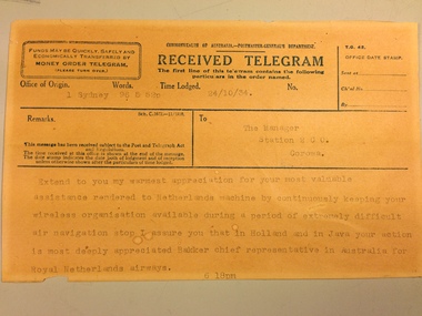 National Communication Museum
Document - Telegram, 24/10/1934
This telegram was sent from the Royal Netherlands Airways, Sydney, to the manager of ABC Radio Station 2CO, Corowa, New South Wales. This telegram relates to the 1934 London to Melbourne Air Race. The telegram records the Royal Netherlands Airways' thanks to ABC Radio 2CO radio staff for their efforts in broadcasting an emergency message to the residents of Albury after the Dutch airliner ‘Uiver’ became lost at night in bad weather. As requested local radio listeners drove their cars to the Albury racecourse and illuminated an emergency landing ground using their vehicle headlights. This allowed the lost airliner to land safely.This item relates to the London to Melbourne Air Race of 1934, a significant event that shaped Australia's history as it proved travelling to and from Australia could be done within a reasonable time by air, thereby making the country less isolated. Up to that time Australia was three weeks away from Europe by steam ship. The Air Race was dreamt up by the Lord Mayor of Melbourne, Harold Smith, to commemorate the centenary of Victoria's statehood and was sponsored by the Melbourne chocolate manufacturer Sir MacPherson Robertson. The Royal Netherlands Airways entered a Douglas DC2 plane 'Uiver' - the largest aircraft in the race, and the only one to carry passengers as well as crew, to show that a commercial passenger service to Australia was possible. But in the last leg of the race, the Uiver lost its way in an electrical storm over the Riverina town of Albury. Several communication methods were used to land the plane safely, including the signalling of the word "Albury" in Morse code using the town's street lights. Local ABC Radio station 2CO also made a call for locals to light up a makeshift landing strip for the plane at the town's racecourse. The plane landed safely and the next morning with the help of the townspeople who pulled it out of the mud, took off and finished the race in second place. The story of the Uiver points to the importance of communication in its various forms: two-way and broadcast radio, Morse, and light signals. The survival of the Uiver is a reflection of the ingenuity of Australian communications and the solutions that can be found through the sharing of ideas of information. The landing of the Uiver was an important moment in Albury's social history, as residents participated in the rescue of the plane and its passengers, helping the Uiver to continue on its journey and finish second in the Race. When the Uiver crashed in the Syrian Desert in December 1934, Albury residents contributed to a memorial which honoured those who were killed. Beige paper telegram printed with black ink and overwritten with typewriter. Telegram split into sections designating details of the telegram, details of the recipient and a space for the transmitted message. A small section of paper is missing from bottom left corner."Extend to you my warmest appreciation for your most valuable / assistance rendered to Netherlands machine by continuously keeping your / wireless organisation available during a period of extremely difficult / air navigation stop I assure you that in Holland and in Java your action / is most deeply appreciated Bakker chief representative in Australia for / Royal Netherlands airways. / 6 18pm"telegrams, telegraphic messages, communications, radio, uiver, royal netherlands airways, albury, london to melbourne air race, morse code -
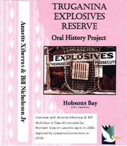 Truganina Explosives Reserve Preservation Society Inc (TERPS)
Digitised Oral History – Truganina Explosives Reserve - Tape 8 Annette Xibarras and Bill Nicholson Jnr, 2018
The interviews were recorded in 2000 by Bronwen Gray and Alan Young for the production of Unreserved, Stories from Truganina Explosives Reserve, animated stories from past residents, workers and interested people of the Reserve (subject to copyright 2004). Annette Xibarras and Bill Nicholson Jnr discuss the indigenous significance of the Truganina Explosives Reserve. At the time of the interview Annette was the manager of the Kulin Nations Cultural Heritage Organisation. Bill, a Wurundjeri Elder, was a Wurundjeri Cultural Officer. They discussed their childhood, aboriginal customs, connection with the land and the locating of aboriginal remains at the Museum of Victoria and the re-burial at the site where they were found. A primary source of information on memories of the Truganina Explosives Reserve and Altona,VictoriaDigital copy of original cassette recorded in 2000 and digitised in 2018julia jones, princess balam balam, archaeological survey, middens, wurundjeri, kulin nations, coranderrk, braybrook, sacred sites, mt william, bunurong, museum victoria, altona, martha nicholson -
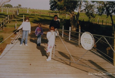 Melton City Libraries
Photograph, Geoff Collins, Debbie, Coralie and Kim Barrie, 1987
Charles Ernest Barrie b. Ballarat 1871 d. 1931 In May 1911 he purchased the property known as ‘Darlingsford.’ The name of the property is derived from Thomas Bell Darling the purchaser of 176 acres of Crown Grant land on the 29-3-1853 which formed part of the Barrie farm acreage. His three sons continued in the family farming tradition in Melton for the rest of their lives. By 1982 the last remaining connection with the ‘Darlingsford’ property and the Barries. Sons, Ernest (Bon) finally ceased. Edgar died in 1975, Ernest in 1985 and Tom in 1990. Bridge built in 1915. Geoff Collins, Debbie, Coralie and Kim Barrie entering Darlingsford property over bridge built in 1915local identities, landscapes of significance -
 Bendigo Military Museum
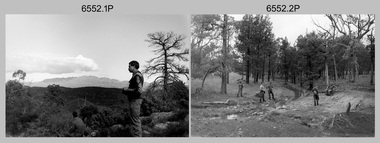
Photograph - 4th Field Survey Squadron Adventurous Training, Wilpena pound, Flinders Ranges, SA, 1989
This is a set of 43 photographs of a 4th Field Survey Squadron adventurous training held at Wilpena pound, in the Flinders Ranges of South Australia in 1989. It is evident the training focussed on teamwork, leadership, abseiling, rock climbing, field craft and living off the land survival skills. Elements from units of the Army Reserve also participated in the training. In this photo set, one of 4th Field Survey’s sections participated in abseiling and trekked to the highest mountain in the Flinders Ranges – St. Mary’s Peak. Refer to items 6553.56P for additional colour photographs taken during the adventurous training exercise.This is a set of 43 photographs of 4th Field Survey Squadron personnel undergoing adventurous training held at Wilpena pound, in the Flinders Ranges of South Australia in 1989. The black & white photographs are on 35mm negative film and are part of the Army Survey Regiment’s Collection. The photographs were scanned at 96 dpi. .1) - Photo, black & white, 1989. L to R: SGT Laurie Justin, SGT Stu Symonds. .2) - Photo, black & white, 1989. L to R: SGT Stu Symonds, CPL Roger Graf, SSGT Max Coletti, SPR Cheryl Deluca-Cardillo, SPR Andrew Quin. .3) & .4) - Photo, black & white, 1989. Wilpena Pound topography. .5) - Photo, black & white, 1989. SGT Stu Symonds. .6) - Photo, black & white, 1989. Abseiling ropes and equipment. .7) to .16) - Photo, black & white, 1989. Abseiling activities, unidentified soldier. .17) to .18) - Photo, black & white, 1989. Abseiling activities, CPL Michelle Griffith. .19) - Photo, black & white, 1989. L to R: unidentified (x5), SGT Mick Hogan, unidentified (x3). .20) - Photo, black & white, 1989. L to R: CPL Roger Graf, CPL Michelle Griffith, SPR Cheryl Deluca-Cardillo, SGT Laurie Justin, SSGT Max Coletti, SPR Andrew Quin. SGT Stu Symonds. .21) - Photo, black & white, 1989. L to R: unidentified (x2), SGT Stu Symonds. .22) & .23) - Photo, black & white, 1989. Wilpena Pound topography. .24) - Photo, black & white, 1989. SSGT Max Coletti. .25) - Photo, black & white, 1989. SSGT Max Coletti, SPR Cheryl Deluca-Cardillo, SGT Stu Symonds. .26) - Photo, black & white, 1989. SGT Stu Symonds. .27) - Photo, black & white, 1989. L to R: CPL Michelle Griffith, SPR Cheryl Deluca-Cardillo, SSGT Max Coletti, SGT Laurie Justin, SPR Andrew Quin, CPL Roger Graf, SGT Stu Symonds. .28) &.29) - Photo, black & white, 1989. Wilpena Pound topography. .30) - Photo, black & white, 1989. SGT Stu Symonds. .31) - Photo, black & white, 1989. CPL Michelle Griffith. .32) - Photo, black & white, 1989. L to R: CPL Michelle Griffith, SGT Stu Symonds, SSGT Max Coletti, SGT Laurie Justin. .33) - Photo, black & white, 1989. L to R: CPL Michelle Griffith, SGT Stu Symonds, CPL Roger Graf (standing), SSGT Max Coletti, SGT Laurie Justin. .34) - Photo, black & white, 1989. L to R: SGT Stu Symonds, CPL Michelle Griffith, CPL Roger Graf (standing), SSGT Max Coletti, SGT Laurie Justin. .35) to .37) - Photo, black & white, 1989. Wilpena Pound topography. .38) - Photo, black & white, 1989. SPR Cheryl Deluca-Cardillo. .39) - Photo, black & white, 1989. L to R: CPL Michelle Griffith, SGT Stu Symonds, SPR Andrew Quin, SGT Laurie Justin. .40) &.41) - Photo, black & white, 1989. Wilpena Pound topography. .1P to .43P – There are no personnel identified. ‘1989 ADV TRAINING’ annotated on negatives sleeve.royal australian survey corps, rasvy, 4 fd svy sqn -
 Bendigo Military Museum
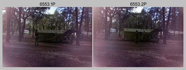
Photograph - 4th Field Survey Squadron Adventurous Training, Wilpena pound, Flinders Ranges, SA, 1989
This is a set of 55 photographs of a 4th Field Survey Squadron adventurous training held at Wilpena pound, in the Flinders Ranges of South Australia in 1989. It is evident the training focussed on teamwork, leadership, abseiling, rock climbing, field craft and living off the land survival skills. Elements from units of the Army Reserve also participated in the training. In this photo set, one of 4th Field Survey’s sections participated in abseiling and trekked to the highest mountain in the Flinders Ranges – St. Mary’s Peak. Refer to item 6552.43P for black & white photographs taken during the adventurous training exercise.This is a set of 55 photographs of 4th Field Survey Squadron personnel undergoing adventurous training held at Wilpena pound, in the Flinders Ranges of South Australia in 1989. The colour photographs are on 35mm negative film and are part of the Army Survey Regiment’s Collection. The photographs were scanned at 96 dpi. .1) & 2)- Photo, colour, 1989. Base camp. WO1 Bill Griggs 2nd from left, remainder unidentified. .3) - Photo, colour, 1989. Old homestead inside Wilpena Pound. SPR Cheryl Deluca-Cardillo, 2nd from left, remainder unidentified. .4) - Photo, colour, 1989. Wilpena Pound topography. .5) - Photo, colour, 1989. Abseiling activities, unidentified personnel. .6) & .7) - Photo, colour, 1989. Flinders Ranges topography. .8) - Photo, colour, 1989. Abseiling activities. L to R: SSGT Max Coletti, SGT Stu Symonds. .9) - Photo, colour, 1989. Abseiling activities, unidentified personnel. .10) - Photo, colour, 1989. Flinders Ranges topography. .11) - Photo, colour, 1989. Abseiling activities. L to R: unidentified, CPL Michelle Griffith, SGT Stu Symonds. .12) - Photo, colour, 1989. Abseiling activities. L to R: unidentified, SPR Andrew Quin, SGT Laurie Justin, SGT Stu Symonds. .13) - Photo, colour, 1989. Abseiling activities. L to R: SGT Stu Symonds SGT Laurie Justin. .14) - Photo, colour, 1989. Abseiling activities. L to R: unidentified, SGT Stu Symonds. .15) - Photo, colour, 1989. Abseiling activities. SGT Laurie Justin. .16) - Photo, colour, 1989. Abseiling activities. SGT Stu Symonds. .17) & .18) - Photo, colour, 1989. Abseiling activities. SPR Cheryl Deluca-Cardillo. .19) - Photo, colour, 1989. Abseiling activities. L to R: SPR Cheryl Deluca-Cardillo, unidentified. .20) - Photo, colour, 1989. Abseiling activities. SSGT Max Coletti. .21) - Photo, colour, 1989. Abseiling activities. SPR Andrew Quin. .22) - Photo, colour, 1989. Abseiling activities. CPL Michelle Griffith. .23) - Photo, colour, 1989. Abseiling activities. CPL Michelle Griffith. .24) - Photo, colour, 1989. Flinders Ranges topography, unidentified personnel. .25) - Photo, colour, 1989. Flinders Ranges topography, unidentified SGT. .26) to .30) - Photo, colour, 1989. Flinders Ranges topography. .31) - Photo, colour, 1989. Flinders Ranges topography, unidentified personnel. .32) & .33) - Photo, colour, 1989. Flinders Ranges topography. L to R: unidentified, CPL Michelle Griffith, SGT Stu Symonds, CPL Roger Graf, SSGT Max Coletti, SGT Laurie Justin. .34) - Photo, colour, 1989. St. Mary’s Peak. L to R: unidentified, CPL Michelle Griffith, CPL Steve Nokes, SGT Stu Symonds. .35) - Photo, colour, 1989. St. Mary’s Peak. SGT Stu Symonds. .36) & .37) - Photo, colour, 1989. St. Mary’s Peak. CPL Steve Nokes. .38) - Photo, colour, 1989. Flinders Ranges topography. .39) - Photo, colour, 1989. St. Mary’s Peak. SGT Laurie Justin. .40) - Photo, colour, 1989. St. Mary’s Peak. SPR Cheryl Deluca-Cardillo. .41) - Photo, colour, 1989. St. Mary’s Peak. SPR Andrew Quin. .42) - Photo, colour, 1989. Flinders Ranges topography, SGT Stu Symonds. .43) - Photo, colour, 1989. Social activities. L to R: unidentified (x6), CPL Perry Langeberg, SGT Laurie Justin. .44) - Photo, colour, 1989. Social activities. L to R: CPL Perry Langeberg, SGT John Zuringer, SGT Laurie Justin, SGT Mick Hogan, unidentified, SGT Stu Symonds. .45) - Photo, colour, 1989. Social activities. L to R: unidentified (x6), CPL Perry Langeberg, SGT John Zuringer. .46) - Photo, colour, 1989. Social activities. L to R: CPL Jamie McRae, SGT Laurie Justin, SGT Mick Hogan, unidentified, SGT Stu Symonds, SPR Cheryl Deluca-Cardillo, WO1 Bill Griggs. .47) - Photo, colour, 1989. Social activities. L to R: SGT Laurie Justin, unidentified, CPL Steve Nokes, SGT Stu Symonds, SPR Cheryl Deluca-Cardillo, WO1 Bill Griggs, unidentified (x2). .48) - Photo, colour, 1989. Social activities. L to R: CPL Steve Nokes, WO1 Bill Griggs, SPR Cheryl Deluca-Cardillo, unidentified (x2), CPL Steve Ellis, CPL Michelle Griffith, SGT Gill Park. .49) - Photo, colour, 1989. Social activities. L to R: CPL Perry Langeberg, SGT John Zuringer, CPL Jamie McRae, SGT Laurie Justin, SGT Mick Hogan, unidentified, SGT Stu Symonds. .50) - Photo, colour, 1989. Sheep cooking in fire pit. L to R: WO2 Peter Symmans, unidentified (x5), CPL Steve Ellis. .51) - Photo, colour, 1989. Sheep cooking in fire pit. L to R: WO2 Peter Symmans, unidentified. .52) - Photo, colour, 1989. Sheep cooking in fire pit. Unidentified personnel. .53) - Photo, colour, 1989. Cooked sheep removed from fire pit. L to R: unidentified. WO2 Peter Symmans, unidentified. .54) - Photo, colour, 1989. Cooked sheep removed from fire pit. L to R: CPL Michelle Griffith, SGT Gill Park, unidentified, SSGT Max Coletti, unidentified, SPR Cheryl Deluca-Cardillo. .55) - Photo, colour, 1989. Cooked sheep removed from fire pit. L to R: unidentified, CPL Michelle Griffith, WO2 Peter Symmans..1P to .55P – There are no personnel identified. ‘1989 ADV TRAINING’ annotated on negatives sleeve.royal australian survey corps, rasvy, 4 fd svy sqn -
 Forests Commission Retired Personnel Association (FCRPA)
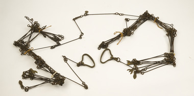
Gunter's Chain
Before metrication was introduced into Australia in the 1970s land was measured in chains and links. Many old parish plans show length measurements in chains and links. Area was shown in acres, roods and perches. Gunter's chain was used for measuring distance in surveying. It was designed and introduced in 1620 by English clergyman and mathematician Edmund Gunter (1581–1626). Gunter developed the measuring chain of 100 links. The chain and the link, became statutory measures in England and subsequently the British Empire. After metrication units of length were measured in meters and area in hectares. The chain was later superseded by steel ribbon tape.The 66 foot long brass Gunter's Chain is divided into 100 links (each 7.92 inches long), and marked off into groups of 10 by shaped tags which simplify intermediate measurement. It was heavy but flexible enough to be dragged through the bush on surveying transects.(Hence the common forestry term "chainman). The chain was a precision part of a surveyor's equipment. It required frequent calibration, yet needed to be sturdy enough to be dragged through rough terrain for years. It has brass hand grips at each end of chain. 1 chain = 100 links = 22 yards = 66 feet = 792 inches. 10 chains = furlong 80 chains = 1 mile 1 acre = 10 square chains = 4 roods (1/4 acre) = 40 perches.forest measurement, surveying, forests commission victoria (fcv) -
 Damascus College
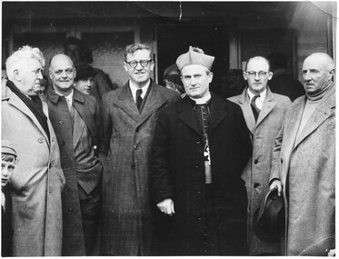
Photograph, Opening of the Mount Xavier Golf Club
From 1949 golf became a regular part of a SHC student's week. With the junior SHC students educated at the Mount Xavier site since 1906, the land adjacent to 'Villa' as it was known, caught the eye of both keen golfer S. J. Weir and Mother Bonaventure Healy. Under their joint direction the golf course took shape, the first to be built and owned by a convent, and on any given Monday of the year could be found teeming with enthusiastic students from Sacred Heart College. Pictured centre left is Australian Minister for Immigration Arthur Calwell, whose daughter Mary attended SHC at that time.Digital Photograph -
 Bacchus Marsh & District Historical Society
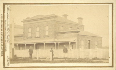
Photograph, Court House Main Street Bacchus Marsh 1883
The Court House in Main Street Bacchus Marsh was built in 1858 using local sandstone. It opened in 1859. It has been used for jury trials, a Court of Petty Sessions, a County Court and a Crown Land sales office. Other uses included an office for the Registrar of Births and Deaths, a Dairy Inspectors office from 1863-1865, and as meeting rooms for the Bacchus Marsh Roads Board, a forerunner of the Shire Council. It was also used by the Bacchus Marsh Shire Council for its offices until at least 1884. In more recent years it has functioned as a Magistrates Court with weekly court sessions. Small sepia unframed photograph on card with gold border framing photograph. Housed in the album, 'Photographs of Bacchus Marsh and District in 1883 by Stevenson and McNicoll'. The view of the Court House building is seen from the northern side of Main Street looking south or south-east. Three men are standing in the street in front of the building. The men on the left and the right wearing police helmets appear to be police officers. The man in the middle is in civilian clothes and might be an officer or employee of the Court House. He has his dog with him. A white picket fence runs along the front of the building. The front courtyard of the building has been renovated since, but this building still operates as a court house.On the front: Stevenson & McNicoll. Photo. 108 Elizabeth St. Melbourne. COPIES CAN BE OBTAINED AT ANY TIME. On the back: LIGHT & TRUTH inscribed on a banner surmounted by a representation of the rising sun. Copies of this Portrait can be had at any time by sending the Name and Post Office Money Order or Stamps for the amount of order to STEVENSON & McNICOLL LATE BENSON & STEVENSON, Photographers. 108 Elizabeth Street, MELBOURNE. stevenson and mcnicoll 1883 photographs of bacchus marsh and district, courthouses, bacchus marsh court house -
 Eltham District Historical Society Inc
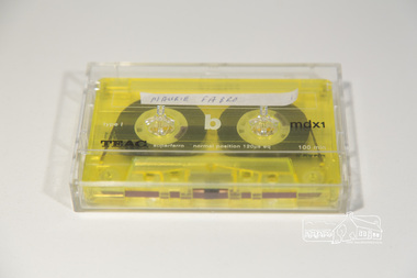
Audio - Audio Compact Cassette Tape, Maurie Fabbro, Audio Recording; Maurie Fabbro with Doug Orford, c.2000
Oral history Interview with Maurie Fabbro conducted by Doug Orford with Mary Reagan at Maurie Fabro's home in Kirby Street, North Eltham, Victoria The interview covers Maurie's life in Eltham. Maurie took over his parents farm which was located opposite Eltham High School and between the Diamond Creek. The house was located in Faulkiner Street. When the land was subdivided, Maurie moved up the hill to the site of the interview. Topics of discussion include: Maurie's Harley Davidson Motorcycle (mention of Keith Gibson), lack of electricity in Faulkiner Street, extreme weather of the past.Audio Cassette tape TEAC mdxi 100 min (yellow) Converted to MP3 file; 79.9MB, 1:03:08oral history, fabbro family, fabbro farm, faulkiner street, eltham, weather, motorcycles, doug orford, maurie fabbro -
 Bendigo Historical Society Inc.
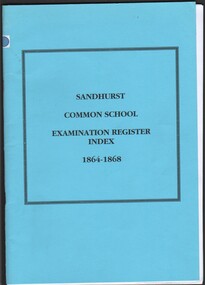
Booklet - Sandhurst Common School, Examination Register Index 1864 - 1868
In 1855 the local Presbyterians were granted land in Myers Street. The first building they erected was a large church hall for use as a day school, Sunday school and temporary accommodation for church services. It was opened on 14th May 1855 as a Denominational School. New educational regulations were introduced in 1864 and were quite specific about standards. Children were required to attend at least 50 days each half year. Thomas H Smith, Inspector of Schools in the Sandhurst district examined the students in attendance and twice a year, over the period of the register. March 1864 to Match 1868. Sandhurst Common School, Examination Register Index 1864 - 1868. Published by Bendigo Area, Australian Institute of Genealogical Studies in 2002. Light blue card cover. Bound spine.education, schools -
 Phillip Island and District Historical Society Inc.
Booklet, Cowes McRae Beach Estate, 1960s
This land was owned by the McRae family, whose wife was a Justice. Hence the street names of McRae and Justice. The weatherboard family home [ originally a guest house called Glen Isle] was at the end of the current Justice Road. The estate was created in the mid 1960s. The house was put on skids and dragged by two tractors and a bulldozer to 364 Church Street while the family home was built at 368 Church Street, Cowes.[ Source Sandra Rocotas, nee McCrae. Facebook Community Noticeboard 5/2/2023. Permission given to use information and photos ] Estate was sold by Rogan Real Estate.HistoricalColoured A4 brochure describing the McRae Beach Estate, including plan of streets and location on Island, photos and description of the Island. Sold by Rogan Real Estate.Cowes McRae Beach Estate - Right in the heart of things .Phillip Island - The Loveliest Isle on Earthhousing, justice family, mcrae family, cowes west, rogan real estate cowes phillip island, glen isla -
 Warrnambool and District Historical Society Inc.
Document, Lease agreement 1862 William Melville & Augustus and James Bostock, 1862
Augustus Bostock was the 9th child of Robert & Rachael Bostock of Vaucluse Epping Forest, Van Diemen’s Land. He was only 4 years old when his mother died. He along with his brothers, was inspired by his father to seek his fortune in the Western District of Victoria. He arrived around 1850. He married Margaret Aitkin in July 1865. Augustus owned several properties in the district and leased others. He sat on the court of Warrnambool, Mortlake or Hexham as required. He resided at Marramook in Hawkesdale and later moved to Vaucluse in Hopetoun Road Warrnambool, where he died in 1920 at the age of 87. He was involved in many aspects of life in the Western District, racing, cricket, and social activities to name a few. James Bostock was the youngest of Robert and Rachel Bostock with his mother dying in childbirth with his delivery. He loved working with horses and was close to his brothers Augustus and John. He was the third of the Bostock brothers to marry an Aitkin sister in this case Alice in 1875. He was a commission agent and money lender in Warrnambool. He died in 1919. In the 1860/70’s William Melville traded in partnership with William Bayles as merchants in Melbourne and as landholders and leases of land in the Western District Weerangourt with 14192 acres freehold. This lease is for approximately 6000 acres and is for a period of 10 years at 2/9 per acre. This is one of a number of documents which relate to the Bostock family who were one of the most important pioneering families of the Western District. They owned and leased various properties around Warrnambool and were involved in many aspects of social and business life. The document itself is indicative of its time and provides an insight into the details and terms of such documents at the time. Ten page, large sheeted document, handwritten in black ink on blue paper. It has been folded in four. Date and names of people involved on one section.William Melville Augustus Bostock James Bostock.warrnambool, bostock, augustus bostock, james bostock, william melville, lease 1862,