Showing 570 items
matching boundary road
-
 Forests Commission Retired Personnel Association (FCRPA)
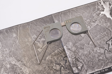
Pocket Stereoscope
... were used to map forest types, timber stands, new roads... were used to map forest types, timber stands, new roads ...This pocket stereoscope was used to view a pair of separate and overlapping aerial photos as a single three-dimensional image. It was small and could be easily used in the field. Larger, mirror stereoscope were also available in some offices. The aerial images were used to map forest types, timber stands, new roads and tracks, firebreaks, boundaries of timber harvesting, plantations, bushfires, insect and disease attack and so on In 1928, the Forests Commission undertook its first major aerial photography project over 15,000 acres of forest which is said to be the first of its kind in Australia. During the Second World War, large areas of Victoria were photographed by RAAF and used to produce orthophoto maps. By 1945 aerial photography of 13,000 square miles (3.4 M ha) was completed, including much of the inaccessible eastern forests. The Forests Commission started developing its own small format photography in the early 1970s. Simple, cheap and rapid methods of obtaining photographs using 70mm and 35mm cameras were developed Small pocket stereoscope to interprete aerial photographs in the field Adjustable lenses on foldaway wire legsSokkisha Tokyoforest measurement -
 Southern Sherbrooke Historical Society Inc.
Information folder - Madigan Cottage
... in the area. Its retention in its site close to the road boundary ...The buildings are probably rare remnant examples of their type in the local area and as such are significant to the settlement of Menzies Creek. The dwelling is significant as a longstanding marker of the Madigan family who were original settlers in the area. Its retention in its site close to the road boundary expresses and maintains a connection with early settlement and rural lifestyles in Menzies Creek over the last century. The old shed is of interest as a local example of bush construction, particularly in context with the cottage and farm environs. Without the life of the farm and other elements presumed now gone, its value is lessened.Folder containing information pertaining to the history of Madigan Cottage, Menzies Creek. NB: the shed was demolished in November 2001 and the cottage burned down sometime later. Contents:- Letter, Southern Sherbrooke Historical Society to Shire of Yarra Ranges, dated 9th March 2001, re. sale of property and need for it to be included in shire's Heritage Study. -Letter, shire to society, dated 20th March 2001, reply to above. -Letter, shire to society, dated 15th May 2001, follow-up to above, requesting more information. -Letter, society to shire, dated 30th May 2001, responding to above and including a copy of information previously sent to Chris Johnston, Heritage Study consultant. -Letter, society to shire, undated, noting intention to lodge an objection to proposed application for development on site. -Letter, shire to society, dated 22nd October 2001, advising of consultation meeting. -Yarra Ranges Shire Heritage Study Place Nomination form for Madigan Cottage, prepared by Marian Matta, includes nine colour photos and diagram showing where photos were taken from. -Black and white copies of photos. -A3 copy of real estate advertisement, "Mount Evergreen Estate" dated 21st April 1924. -A3 map showing proposed resubdivision boundary variation, drawn up for Mr. P. Melville, undated but 1990s. -Copy of application for a planning permit, dated 6th August 2001, including letter by Nick Jonkers describing proposed new buildings, site map showing current vegetation, letter re. proposed removal of vegetation, subdivision plan dated March 1998, and larger scale map printed from shire website on 10th August 2001. -5 A3 sheets showing site and house plans drawn up for Mr & Mrs N. Jonkers, dated July 2001.madigan cottage, menzies creek, madigan family, mount evergreen, patrick madigan -
 Melbourne Tram Museum
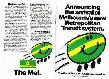
Pamphlet, The Met, "Announcing the arrival of Melbourne's new Metropolitan Transit system", late 1983
Set of 9 pamphlets about the Neighbourhood ticket system - basically the same with changes for each neighbourhood. .1 - Eight page, A4, colour printed on gloss paper, centre stapled, titled "Announcing the arrival of Melbourne's new Metropolitan Transit system - Ringwood Neighbourhood" Explains the revised ticketing system, known as Neighbourhoods, notes the formation of The Met, uses a cartoon characterisation of vehicles, explains how the system works, boundaries, various options, travel cards, concessions and introductory offers. Pamphlet focused on the Ringwood Zone, has a detailed map of the public transport routes within the zone. 2nd copy added 14-5-2016 from the estate of Charles Craig. .2 - Inner .3 - St Albans .4 - Dandenong .5 - Box Hill - (two copies held) .6 - Frankston .7 - Moorabbin .8 - Greensborough .9 - Werribee - added 26/10/2016.trams, tramways, map, the met, tickets, fares, ringwood -
 Melbourne Tram Museum
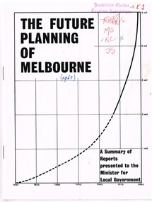
Document - Report, Commerce News, "The Future Planning of Melbourne - A summary of Reports - Minister for Local Government", 1967
Printed report or paper, 16 pages on gloss paper, centre stapled titled "The Future Planning of Melbourne - A summary of Reports presented to the Minister for Local Government" looking at the growth of Melbourne, water supply, metropolitan boundaries, 1966-67. Includes submissions from Town and Country Planning Association, MMBW, Regional planning, decentralisation, finance, commuter services. Process created by Rupert Hamer, the Local Government Minister at the time. Published as a supplement to "January Commerce News.""4E1" in ink on front cover, AETA stamp, the date "(1967)" and peoples initials on the front cover.trams, tramways, melbourne, victoria, development -
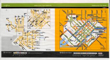 Melbourne Tram Museum
Poster, Yarra Trams, "Melbourne Tram Network", Nov. 2005
Full colour poster printed, A3 size, on laminated sheet - titled "Melbourne Tram Network. Shows a diagrammatic layout of the Melbourne tram system, shows zones (2 zones), CBD, tram terminuses including the City Saver boundary. Has the Yarra Trams and Metlink logos. Dated Effective November 2005trams, tramways, yarra trams, metlink, maps, metcard, tickets, city section -
 Wodonga & District Historical Society Inc
Map - Tulloch & Brown's Map of the Colony of Victoria, Tulloch & Brown, 1856
The map was created by Tulloch and Brown. David Tulloch was one of the earliest engravers and lithographers in the state of Victoria. He arrived in Melbourne from Greenock, Scotland, on 3 January 1849. Following the discovery of gold Tulloch went to the Victorian goldfields in 1851, commissioned to make sketches of the diggers and the diggings for Ham’s Illustrated Australian Magazine. In November 1852 Tulloch set up in business as engraver, draughtsman, copperplate printer and lithographer. Tulloch took a map engraver, James Davie Brown, into partnership in March 1853; the several maps and specimens of commercial engraving they showed at the 1854 Melbourne Exhibition were awarded a bronze medal. That year Tulloch and Brown also received a silver medal at the Victorian Industrial Exhibition. The partnership was dissolved towards the end of 1856.This is a very early map of the Colony of Victoria including Belvoir (now know as Wodonga).A foldable map mounted on linen and with a board cover. It records the Colony of Victoria according to Surveyor's Records revised in 1857. Areas of the map are shaded to highlight different counties.At bottom right hand section of map: Tulloch & Brown's map of the Colony of Victoria : comprising part of New South Wales, the boundaries, counties, also seaport & inland townships, the gold fields with the latest discoveries, roads, tracks, &c. &c. / compiled from drawings in the Survey Office and correctly revised till 1857. Respectfully dedicated by Permission, to the Honorable Captain Andrew Clarke R.E. Surveyor General of Victoria by His Obediant Servants Tulloch & Brown, Engravers & Publishers, Melbourne". At bottom right below border : Published as the Act directs by the Proprietors, Melbourne, 1st Feb. 1856. tulloch and brown maps, rare maps victoria, victorian cartography -
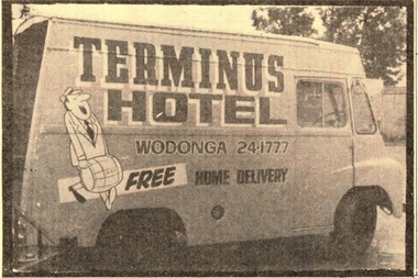 Wodonga & District Historical Society Inc
Photograph - Terminus Hotel Delivery Van 31 July 1971
The Terminus Hotel, Wodonga was built by James Thompson Hatch in 1873, the same year the railway reached Wodonga from Melbourne. It was named due to its close proximity to the railway terminus. It was sold to Messrs George Day and Kenneth McLennan of Albury. It was first licenced to J.G. Morton in January 1874. Annie Allen, from Ireland, took over as licensee of the hotel containing 14 rooms in 1879, after she and her husband, George James Allen, purchased it. In 1887 they added a new wing on the south boundary of the property next to Peter McLean’s store at 81 Sydney Road. The architects for the new wing were Gordon and Gordon. A billiard room, a dining room, and 18 other rooms were added on the vacant block of land between the Hotel and the Bank of Victoria. A balcony 6 feet wide was added on the north side. Included in the plans was the latest patent elevator, later known as a dumb waiter. Allen died in 1889 aged 52, and Annie Allen continued to run the Terminus. She later married John G. Haldon and was licensee of the hotel until December 1898 when the licence was transferred to William Carkeek. Carkeek, from Cornwall, arrived in the colony around 1860 and is considered one of the founders of Tallangatta. In November 1903, the license was transferred to Daniel Crawford, then in 1906 it was transferred to Mr Stephen Carkeek. In 1916 it passed into the hands of Mr H. W. Allen of Rutherglen, son of Mr George James Allen. On 1st June 1998 the Terminus Hotel was destroyed by fire. Estimates of damage range from between a conservative $750,000 to as high as $2 million. The remains of the building were demolished in 1999.The Terminus Hotel was one of the earliest hotels in Wodonga with clear links to the establishment of the railway line. It was an important business and meeting place for social gatherings.In 1879, the Terminus Hotel was purchased by Annie and George Allen. The hotel was advertised as a two storey brick building with bar, large dining and four rooms on the ground floor, all and commodious cellar. Upstairs a large parlour and 13 bedrooms. There was also a four-roomed weatherboard cottage, a blacksmith's shop and other buildings. The Allens had about 20 years of ownership, with Annie continuing to hold the licence under her new married name of Annie Haldon after George had died in 1889. In 1888, the Allens undertook extensive additions and renovations. Annie remained as the proprietor of the building until her death in 1904, but the business was leased to William Carkeek in December 1898. The building was eventually auctioned as part of the finalising of Annie's estate in 1909.hotels wodonga, businesses wodonga, terminus hotel wodonga -
 Wodonga & District Historical Society Inc
Photograph - Terminus Hotel 1937
The Terminus Hotel, Wodonga was built by James Thompson Hatch in 1873, the same year the railway reached Wodonga from Melbourne. It was named due to its close proximity to the railway terminus. It was sold to Messrs George Day and Kenneth McLennan of Albury. It was first licenced to J.G. Morton in January 1874. Annie Allen, from Ireland, took over as licensee of the hotel containing 14 rooms in 1879, after she and her husband, George James Allen, purchased it. In 1887 they added a new wing on the south boundary of the property next to Peter McLean’s store at 81 Sydney Road. The architects for the new wing were Gordon and Gordon. A billiard room, a dining room, and 18 other rooms were added on the vacant block of land between the Hotel and the Bank of Victoria. A balcony 6 feet wide was added on the north side. Included in the plans was the latest patent elevator, later known as a dumb waiter. Allen died in 1889 aged 52, and Annie Allen continued to run the Terminus. She later married John G. Haldon and was licensee of the hotel until December 1898 when the licence was transferred to William Carkeek. Carkeek, from Cornwall, arrived in the colony around 1860 and is considered one of the founders of Tallangatta. In November 1903, the license was transferred to Daniel Crawford, then in 1906 it was transferred to Mr Stephen Carkeek. In 1916 it passed into the hands of Mr H. W. Allen of Rutherglen, son of Mr George James Allen. On 1st June 1998 the Terminus Hotel was destroyed by fire. Estimates of damage range from between a conservative $750,000 to as high as $2 million. The remains of the building were demolished in 1999.The Terminus Hotel was one of the earliest hotels in Wodonga with clear links to the establishment of the railway line. It was an important business and meeting place for social gatherings.In 1879, the Terminus Hotel was purchased by Annie and George Allen. The hotel was advertised as a two storey brick building with bar, large dining and four rooms on the ground floor, all and commodious cellar. Upstairs a large parlour and 13 bedrooms. There was also a four-roomed weatherboard cottage, a blacksmith's shop and other buildings. The Allens had about 20 years of ownership, with Annie continuing to hold the licence under her new married name of Annie Haldon after George had died in 1889. In 1888, the Allens undertook extensive additions and renovations. Annie remained as the proprietor of the building until her death in 1904, but the business was leased to William Carkeek in December 1898. The building was eventually auctioned as part of the finalising of Annie's estate in 1909.hotels wodonga, businesses wodonga, terminus hotel wodonga -
 Wodonga & District Historical Society Inc
Photograph - Terminus Hotel, Wodonga 15 February 1910
The Terminus Hotel, Wodonga was built by James Thompson Hatch in 1873, the same year the railway reached Wodonga from Melbourne. It was named due to its close proximity to the railway terminus. It was sold to Messrs George Day and Kenneth McLennan of Albury. It was first licenced to J.G. Morton in January 1874. Annie Allen, from Ireland, took over as licensee of the hotel containing 14 rooms in 1879, after she and her husband, George James Allen, purchased it. In 1887 they added a new wing on the south boundary of the property next to Peter McLean’s store at 81 Sydney Road. The architects for the new wing were Gordon and Gordon. A billiard room, a dining room, and 18 other rooms were added on the vacant block of land between the Hotel and the Bank of Victoria. A balcony 6 feet wide was added on the north side. Included in the plans was the latest patent elevator, later known as a dumb waiter. Allen died in 1889 aged 52, and Annie Allen continued to run the Terminus. She later married John G. Haldon and was licensee of the hotel until December 1898 when the licence was transferred to William Carkeek. Carkeek, from Cornwall, arrived in the colony around 1860 and is considered one of the founders of Tallangatta. In November 1903, the license was transferred to Daniel Crawford, then in 1906 it was transferred to Mr Stephen Carkeek. In 1916 it passed into the hands of Mr H. W. Allen of Rutherglen, son of Mr George James Allen. On 1st June 1998 the Terminus Hotel was destroyed by fire. Estimates of damage range from between a conservative $750,000 to as high as $2 million. The remains of the building were demolished in 1999.The Terminus Hotel was one of the earliest hotels in Wodonga with clear links to the establishment of the railway line. It was an important business and meeting place for social gatherings.In 1879, the Terminus Hotel was purchased by Annie and George Allen.The hotel was advertised as a two storey brick building with bar, large dining and four rooms on the ground floor, all and commodious cellar. Upstairs a large parlour and 13 bedrooms. There was also a four-roomed weatherboard cottage, a blacksmith's shop and other buildings. The Allens had about 20 years of ownership, with Annie continuing to hold the licence under her new married name of Annie Haldon after George had died in 1889. In 1888, the Allens undertook extensive additions and renovations. Annie remained as the proprietor of the building until her death in 1904, but the business was leased to William Carkeek in December 1898. The building was eventually auctioned as part of the finalising of Annie's estate in 1909.Across top of building "TERMINUS HOTEL" Beneath balcony "ALLEN'S HOTEL"hotels wodonga, businesses wodonga, terminus hotel wodonga -
 Wodonga & District Historical Society Inc
Photograph - Terminus Hotel August 1963
The Terminus Hotel, Wodonga was built by James Thompson Hatch in 1873, the same year the railway reached Wodonga from Melbourne. It was named due to its close proximity to the railway terminus. It was sold to Messrs George Day and Kenneth McLennan of Albury. It was first licenced to J.G. Morton in January 1874. Annie Allen, from Ireland, took over as licensee of the hotel containing 14 rooms in 1879, after she and her husband, George James Allen, purchased it. In 1887 they added a new wing on the south boundary of the property next to Peter McLean’s store at 81 Sydney Road. The architects for the new wing were Gordon and Gordon. A billiard room, a dining room, and 18 other rooms were added on the vacant block of land between the Hotel and the Bank of Victoria. A balcony 6 feet wide was added on the north side. Included in the plans was the latest patent elevator, later known as a dumb waiter. Allen died in 1889 aged 52, and Annie Allen continued to run the Terminus. She later married John G. Haldon and was licensee of the hotel until December 1898 when the licence was transferred to William Carkeek. Carkeek, from Cornwall, arrived in the colony around 1860 and is considered one of the founders of Tallangatta. In November 1903, the license was transferred to Daniel Crawford, then in 1906 it was transferred to Mr Stephen Carkeek. In 1916 it passed into the hands of Mr H. W. Allen of Rutherglen, son of Mr George James Allen. On 1st June 1998 the Terminus Hotel was destroyed by fire. Estimates of damage range from between a conservative $750,000 to as high as $2 million. The remains of the building were demolished in 1999.The Terminus Hotel was one of the earliest hotels in Wodonga with clear links to the establishment of the railway line. It was an important business and meeting place for social gatherings.In 1879, the Terminus Hotel was purchased by Annie and George Allen. The hotel was advertised as a two storey brick building with bar, large dining and four rooms on the ground floor, all and commodious cellar. Upstairs a large parlour and 13 bedrooms. There was also a four-roomed weatherboard cottage, a blacksmith's shop and other buildings. The Allens had about 20 years of ownership, with Annie continuing to hold the licence under her new married name of Annie Haldon after George had died in 1889. In 1888, the Allens undertook extensive additions and renovations. Annie remained as the proprietor of the building until her death in 1904, but the business was leased to William Carkeek in December 1898. The building was eventually auctioned as part of the finalising of Annie's estate in 1909.hotels wodonga, businesses wodonga, terminus hotel wodonga -
 Wodonga & District Historical Society Inc
Photograph - Staff of Terminus Hotel 1919
The Terminus Hotel, Wodonga was built by James Thompson Hatch in 1873, the same year the railway reached Wodonga from Melbourne. It was named due to its close proximity to the railway terminus. It was sold to Messrs George Day and Kenneth McLennan of Albury. It was first licenced to J.G. Morton in January 1874. Annie Allen, from Ireland, took over as licensee of the hotel containing 14 rooms in 1879, after she and her husband, George James Allen, purchased it. In 1887 they added a new wing on the south boundary of the property next to Peter McLean’s store at 81 Sydney Road. The architects for the new wing were Gordon and Gordon. A billiard room, a dining room, and 18 other rooms were added on the vacant block of land between the Hotel and the Bank of Victoria. A balcony 6 feet wide was added on the north side. Included in the plans was the latest patent elevator, later known as a dumb waiter. Allen died in 1889 aged 52, and Annie Allen continued to run the Terminus. She later married John G. Haldon and was licensee of the hotel until December 1898 when the licence was transferred to William Carkeek. Carkeek, from Cornwall, arrived in the colony around 1860 and is considered one of the founders of Tallangatta. In November 1903, the license was transferred to Daniel Crawford, then in 1906 it was transferred to Mr Stephen Carkeek. In 1916 it passed into the hands of Mr H. W. Allen of Rutherglen, son of Mr George James Allen. On 1st June 1998 the Terminus Hotel was destroyed by fire. Estimates of damage range from between a conservative $750,000 to as high as $2 million. The remains of the building were demolished in 1999.The Terminus Hotel was one of the earliest hotels in Wodonga with clear links to the establishment of the railway line. It was an important business and meeting place for social gatherings.In 1879, the Terminus Hotel was purchased by Annie and George Allen. The hotel was advertised as a two storey brick building with bar, large dining and four rooms on the ground floor, all and commodious cellar. Upstairs a large parlour and 13 bedrooms. There was also a four-roomed weatherboard cottage, a blacksmith's shop and other buildings. The Allens had about 20 years of ownership, with Annie continuing to hold the licence under her new married name of Annie Haldon after George had died in 1889. In 1888, the Allens undertook extensive additions and renovations. Annie remained as the proprietor of the building until her death in 1904, but the business was leased to William Carkeek in December 1898. The building was eventually auctioned as part of the finalising of Annie's estate in 1909.hotels wodonga, businesses wodonga, terminus hotel wodonga -
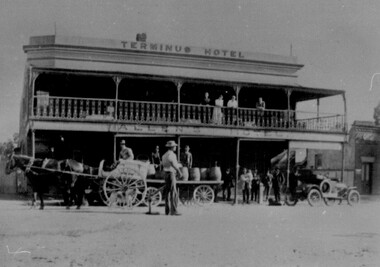
 Wodonga & District Historical Society Inc
Photograph - Carkeek's Terminus Family Hotel, Wodonga, c1890
The Terminus Hotel, Wodonga was built by James Thompson Hatch in 1873, the same year the railway reached Wodonga from Melbourne. It was named due to its close proximity to the railway terminus. It was sold to Messrs George Day and Kenneth McLennan of Albury. It was first licenced to J.G. Morton in January 1874. Annie Allen, from Ireland, took over as licensee of the hotel containing 14 rooms in 1879, after she and her husband, George James Allen, purchased it. In 1887 they added a new wing on the south boundary of the property next to Peter McLean’s store at 81 Sydney Road. The architects for the new wing were Gordon and Gordon. A billiard room, a dining room, and 18 other rooms were added on the vacant block of land between the Hotel and the Bank of Victoria. A balcony 6 feet wide was added on the north side. Included in the plans was the latest patent elevator, later known as a dumb waiter. Allen died in 1889 aged 52, and Annie Allen continued to run the Terminus. She later married John G. Haldon and was licensee of the hotel until December 1898 when the licence was transferred to William Carkeek. Carkeek, from Cornwall, arrived in the colony around 1860 and is considered one of the founders of Tallangatta. In November 1903, the license was transferred to Daniel Crawford, then in 1906 it was transferred to Mr Stephen Carkeek. In 1916 it passed into the hands of Mr H. W. Allen of Rutherglen, son of Mr George James Allen. On 1st June 1998 the Terminus Hotel was destroyed by fire. Estimates of damage range from between a conservative $750,000 to as high as $2 million. The remains of the building were demolished in 1999.The Terminus Hotel was one of the earliest hotels in Wodonga with clear links to the establishment of the railway line. It was an important business and meeting place for social gatherings.A black and white image printed on canvas. The image includes Carkeek's Terminus Family Hotel in Sydney Road, now named High Street, Wodonga, Victoria. Other businesses shown include a produce store, D.M. Staveley Taylor, John Whan General Store. The railway track can be seen in the foregrounc.Across side of building "CARKEEK'S TERMINUS FAMILY HOTEL" On bottom left "High Street Wodonga 1890s"carkeek, terminus hotel, hotels wodonga -
 City of Greater Bendigo - Civic Collection
Functional object - Metal Box, Unknown
The first local government authority for Marong was the Marong Road District (an early form of single-purpose local government), which was proclaimed on 19 August 1860. Its boundary was altered twice in 1862 and on 12 December 1864 it was re designated as a Shire. It absorbed Raywood Borough in 1915, and was proclaimed a Rural City in 1990. On 2 December 1994, with the creation of Greater Bendigo City Council, it was abolished by being amalgamated with Bendigo City, Eaglehawk Borough, Huntly Shire, part of McIvor Shire, part of Metcalfe Shire and Strathfieldsaye Shire to form the City of Greater Bendigo. This metal box contained a roll of admission tickets and was possibly used for holding cash at the swimming pool or other municipal facility. Lockable painted metal box. Shire of Marongshire of marong -
 Flagstaff Hill Maritime Museum and Village
Photograph - Historical, Flagstaff Hill, John Lindsay, View of the Bay from the south boundary of the Ports and Harbours land, 1970s
The photograph shows the view of the shore and Lady Bay with the Breakwater and Middle Island all visible. It was taken to show that the Flagstaff Hill area was unlikely to have any further development between it and the Bay, with the view of development of the Flagstaff Hill Maritime Museum and Village. This photograph, a print, is one of a set of five that show the site of Flagstaff Hill. The photographer was John Lindsay, Founding Director of Flagstaff Hill Maritime Museum and Village, with the words "Photo J Lindsay" on the back. It was taken in the early 1970s during the initial stages of the development of Flagstaff Hill as a Museum and Maritime Village. The photographs belonged to the donor's grandparents, who lived in the Warrnambool district of Allansford/Naringal. The photograph is a record of the site and surrounds of Flagstaff Hill Maritime Museum and Village before its development and opening in 1975. It shows the Surfside Holiday Park, Surf Lifesaving Club, and the Breakwater. The photograph is significant for recording the location and condition of the Lower Lighthouse on the Hill.Coloured photograph, glassy print, one of a set of five. Flagstaff Hill's Lower Lighthouse is in the foreground above the Surfside Holiday Park. To the right of centre is the Surf Lifesaving Club. In the background is Lady Bay and the Breakwater and Middle Island, with the Southern Ocean the other side. The photograph's paper has the printer's watermark and a pencilled inscription on the back. The early 1970s scene was photographed by John Lindsay, Warrnambool.Label on the back: "VIEW OF THE BAY FROM the southern boundary of the Ports and Harbours land. No development below this area is likely to obstruct the view, due to the steep grade down to the Southern boundary of Flagstaff Hill property." Handwritten in pencil: "Photo J Lindsay"flagstaff hill, flagstaff hill maritime museum and village, warrnambool, maritime museum, maritime village, great ocean road, shipwreck coast, 1970s, photograph, surfside holiday park, lady bay, flagstaff hill site, john lindsay, lower lighthouse, lower light, surf lifesaving club, breakwater, middle island, ports and harbours -
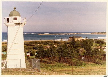
 Ringwood and District Historical Society
Newspaper, Scrapbook Clipping, Library Collection, Ringwood, Victoria
Newspaper Clipping from the "Mail", 03-09-1996. P5. Yes to seven wardsMaroondah Council's recently announced ward boundaries have been published in the Government Gazette. Each of the seven was approved by Local Government Minister Rob Maclellan -
 Ringwood and District Historical Society
Newspaper, Scrapbook Clipping, Library Collection, Ringwood, Victoria, `
``Newspaper clipping from "The Post" 6-7-94 P9 Ringwood Mayor's Column. Cr Margaret Cheevers.Cr Cheevers welcomed John Binnion to the Ringwood library. He gave an excellent report on the progress of the new library.The Mayor also mentioned that Ringwood was in the government's next review of local government boundaries. A new Public Relations Consultant, Kate Shea, was welcomed to Ringwood Council` -
 Ringwood and District Historical Society
Newspaper, Scrapbook Clipping, Library Collection, Ringwood, Victoria, `
``Newspaper clipping from "The Mail" 8 -6- 94 P1 - Council fear's it's fighting a losing battle by Christine McTigheCroydon Council fears it is one step closer to a merger with Ringwood following the release of the Local Government Board's final report on the boundaries of 21 inner metropolitan councils. Croydon Mayor Cr Les Wilmott favors taking over the urban areas of Lilydale, namely Kilsyth, Mooroolbark and Wonga Park. The council fears that the Board has made up its mind to a merger between Croydon and Ringwood, which the councils don't want.` -
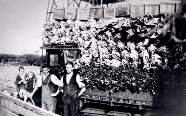 City of Kingston
Photograph - Black and white, c. 1920
... -roomed house in East Boundary Road, in the area then called East ...Market gardening was an integral part of the development of the area now known as Kingston. In this image there are two men standing beside a truck loaded with vegetables. Painted on the truck are the words South Rd, A & H Marriott, indicating these men are from the Marriott family. The truck appears to be a Republic Commercial Car by Republic Motor Truck Co, Michigan, c. 1916.The Marriott family arrived in Port Phillip in 1857. It wasn't until 1876 that the family purchased 30 acres with a four-roomed house in East Boundary Road, in the area then called East Brighton.Black and white image of two men standing in front of a truck fully loaded with vegetables intended for market. There are also two children standing in front of the truck.Handwritten in black ink on a round red sticker on the reverse: X18 Handwritten in red ink on reverse: 35% -
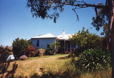 Lakes Entrance Regional Historical Society (operating as Lakes Entrance History Centre & Museum)
Photograph, 1999
Built on site of Northrope's original bark residence (1890c).Colour photograph of a property known as Bunga Haven at 127 Lake Bunga Road. A timber dwelling with corrugated iron roof overlooking Lake Bunga and Bass Strait. Set in rustic garden and native bushland. Dropped log boundary fence and brush gate. Lakes Entrance Victoriaoil and gas industry -
 Ringwood and District Historical Society
Map - Public Land Sale by Thomas Ham, 2000 Acres for Sale - Crown Sections 20, 23, 24 - Ringwood, Victoria - 1855
Two 1850s surveyor's maps on cardboard backing showing area from Melbourne extending East beyond Bulleen and Nunawading. Detailed description of lots for sale and navigational directions to the property from Richmond by Thomas Ham, Victorian public servant, map maker, publisher, lithographer and original Ringwood land owner. Inset map enlarging area between Yarra River and Dandenong Creek, with southern boundary of allotments later forming part of Oban Road, North Ringwood.TRANSCRIPT: "This really valuable Property is now offered to the public for sale, in lots to suit purchasers at the Iow rate of £1 per Acre for 80 acres and upwards, and £1.10s per Acre for any smaller portion. Terms of payment Half Cash, Balance in 6 and 12 months, bearing 8 per cent interest. The Estate is well wooded with Gum, Cherry Tree and Stringy Bark, with Wattle in the valleys of the several creeks. Every lot is Staked and Trenched at the corners marked on the Plan thus - The Surveyor has carefully sub-divided the Property, in order to give every Farm a Creek for Water, Valley for Cultivation, and Hills for House and Grass Paddock. The ROADS have been very carefully laid out so as to give a firm, well drained, and nearly level road to each Homestead. Intending purchasers can readily find the property by the following directions, viz: Start from Richmond Bridge, at Hawthorne, then take the left-hand road to KEW. When at the "Woodman Inn", take the Cotham Road to the right, bearing due east, keep this Road, passing Trainor's "White Horse" Inn, and before you leave the fences, you will see calico bills (see margin) nailed to the Trees on the bush track leading to the Upper Yarra country, follow the Bills till you come to the SOUTH boundary line of the Property, which bears East and West (see Plan) where you will see Bills nailed up "THIS PROPERTY FOR SALE, etc." The Bills from Town lead direct to where Mr. Jull is erecting his Store, and arrangements have been made with him to show the lots to intending purchasers free of charge. At the respective corners of the lots the Bills are nailed up double, with numbers to denote the lot, and that the corner stake is adjacent. Any parties wishing to proceed to the property by way of BULLEEN will find Bills nailed on the Trees, commencing at the NEW INN, at "Wilson's Slip Rail." Keep this Track till you come to the Log Bridge, over the Deep Creek at Bloxhome's Paddock; go through the land now being cleared; keep the track over the hill till you come to an Iron House, you will then be on the property, which Iies to the North and East as per Plan. Follow the Bills till you come to Mr. Jull's Store, etc. etc. Further particulars can be had from the Agent for the Property. THOMAS HAM. " -
 Bendigo Historical Society Inc.
Document - Golden City Implements Foundry, Ironbark, Bendigo, 1960-1980s
This foundry had been a landmark in Mt Korong Road for many years. It began with an Osborne and Mitchell. After 1914 when mining declined, it became the Golden City Implement boundary and the name can still be seen painted on on the façade which faces the intersection of Marong Road (Calder highway) and Eaglehawk Road. The interior is a mass of used and un-used machinery scattered amongst modern lathes and more modern apparatus. The yard was a fascinating graveyard of past times, with old mining and agricultural scrap everywhere mixed up with coke and slag from the smelting sheds at the rear. A feature of the foundry was the manufacturer of cast iron lace. National Trust Survey Data Sheet and article from the Bendigo Advertiser November 4th 1981. Osbornes Ironbark Foundryhistory, national trust bendigo collection, bendigo, foundary, iron bark bendigo -
Bendigo Historical Society Inc.
Plan - MARKS COLLECTION: PLAN OF UNDERGROUND SURVEY G. DENNIS MINE
Plan drawn on heavy parchment 'underground survey G. Dennis' printed on top of plan. Plan shows boundary lines and peg site. P. Bonati claim marked on bottom of plan. B. Letter with plan on letterhead 'City of Sandhurst, Town Hall, July 2nd. 1873' Addressed to Mr. George Dennis, Sir, In reply to your letter of the 19th. Ulto I am empowered to state that subject to the formation of the road referred to, your existing rights are conserved, and the council will undertake not to object to the renewal of your least. The only conditions being that you shall not sink a shaft in the street or attempt to obstruct it when formed. I have the honour to be, Sir, your obedient servant, Geo Fletcher, Town Clerk.bendigo, mining, g. dennis claim -
 Bendigo Historical Society Inc.
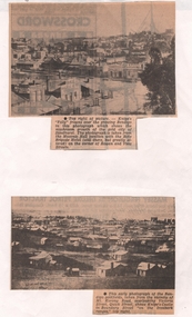
Newspaper - NEWSPAPER CLIPPINGS EARLY PHOTOGRAPHS OF BENDIGO STREETSCAPE, Unknown
Two Black & White Early Photographs of Bendigo. (Photograph 1) Panorama is taken from the Masonic Hall location with the Rifle Brigade Hotel on the corner of Rowan and View Streets and Knipe's Folly in top right of image. (Photograph 2) An early photograph of the Bendigo Goldfields the suburb of Ironbark taken from the vicinity of Mt. Korong Road, overlooking Victoria Street and Quick Street. Image shows Knipe's Castle in Boundary Street ''on the Ironbark Ranges'' top right.bendigo, streetscape, rowan & view st, mt korong rd -
Bendigo Historical Society Inc.
Map - MAP WHITE HILL TO HUNTLY
Map of Bendigo creek and adjacent leads - White Hills to Huntly replotted from old 4 chain to 1 inch survey of 1860 by G. W. Hart - Surveyor. Base of roads and streets taken from D.L.S. 1 . 10000 base maps. Legend: battery site, puddling mill site, dam bank site, cutting altering course of creek, lead boundaries.bendigo, mining -
 Bendigo Historical Society Inc.
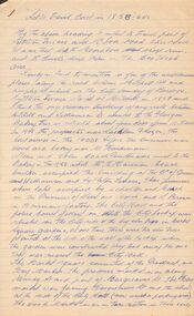
Document - LET'S TRAVEL EAST IN 1858 - 60'S
... Mitchell Street, along Lyttleton Terrace and McIvor Road... Lyttleton Terrace and McIvor Road to the City boundary ...Nine pages of handwritten account of businesses from Mitchell Street, along Lyttleton Terrace and McIvor Road to the City boundary on the Bendigo side of Murphy Street.document, let's travel east in 1858 - 60's, moorabbee sheep run, curr's sheep run, glasgow bakery, lachlan frazer, mr hardiman, steen and holm coach painters, mr h haisman coach builder, scholton and march, march and s brown, haisman factory, city hall, police court, city lockup, market square, senior citizens club, weighbridge, dunlop tyre service station, tommy burns, matt lynch, tom & mick kennedy, darling hotel, the innes, mr bullens fruit shop, bricklayers arms hotel, cheshire arms hotel, mr i boffey, newcombe's timber yard, quinns monumental establishment, alexandra fountain, cumberland hotel, sannaman's coach factory, town hall hotel, her majesties open air picture show, mr r anderson, john ohagan, sandhurst hotel, the melbourne café, haymarket hotel, the old haymarket hotel, the market ale house, the prince of wales theatre, manchester hotel, mr john doran, dr backhaus, manchester hall, the bendigo star, james griffen coach factory, mr george lansell, whitting's marine store, cartrights marine store, sandhurst flour mills, mr john buckley, moorhead hay and corn mills, brian boru hotel, mr m r?dea, mr worth, mr condon, mr c cahill, nolan family, mr sides, the nailons, mrs boyan, jacky bryant, john oconnell general store, mr pierce, mr matthews, mr neil ward, mr hagan, william clapton, mr joseph dowd, mr morris, ancient briton hotel, the woolpak, the railway bridge, ampol service station, farrells dairy, farringtons brickworks, jacksons hide & tallow yard, fergusons, royal oak hotel, mr jackson, mr knight, st marys common school no812, mrs rersol, w d quinn, mr march, mr fred randall, mr steeple, the limerick hotel, back creek police shooting range, police station, stone lockup, holts service station, steepe's butcher shop, joch, john hattam -
Bendigo Historical Society Inc.
Map - BENDIGO SHEET 2
Parish map showing the southern section of the City of Bendigo. It shows the city boundary running along Murphy Street, Grave (Patterson) Street, and the turns at the south end of Macdougall Road, the corner of Alder and Aspinal Streets and the corner near the Specimen Hill - Marong roads intersectionH.J. Green Govt. Printer, Melbournemap, bendigo, city streets, city of bendigo, parish map, city boundary -
Bendigo Historical Society Inc.
Map - MINING REPORTS - MAP OF COLLMANN AND TACCHI SHAFT
Hand drawn map showing the Collmann and Tacchi Shaft with No 17 Crosscut with the distances in feet and inches and the compass bearing of each leg. It is beside Mt Korong Road, near Dowding Street. Some boundary lines are drawn. Also on the map is Lansell's C and T across the road.map, bendigo, goldfields, mining reports, map of collmann and tachi shaft, collmann and tacchi shaft, lansell's c and t -
 Eltham District Historical Society Inc
Photograph, Liz Pidgeon, Heritage Excursion; The 1901 Eltham Railway Walk, 3 May 2014
... Station to Ryans Road, which was the boundary of the adjoining... Station to Ryans Road, which was the boundary of the adjoining ...EDHS Member Doug Orford stands by a yarn bombing installation. ewsletter No. 216, May 2014 May Excursion – The 1901 Eltham Railway Walk The railway from Heidelberg to Eltham was opened in 1902. Over the previous year railway construction cut a curving swathe through Josiah Holloway’s 1851 Little Eltham subdivision. The survey plans for the railway show the owners and occupiers of land within Little Eltham affected by the railway alignment and for some distance each side. The plans show houses and other buildings but development at that time was rather sparse. Copies of these plans from the State Library of Victoria collection have been provided to the Society by Alan Sheehan. For our walk on 3rd May we intend to follow the railway from the Eltham Station to Ryans Road, which was the boundary of the adjoining Montmorency Farm. The return will be by way of nearby streets. Along the way we will discuss the details shown on the railway plans as well as more recent railway documents and photographs. At the conclusion and if time permits we can inspect the historical display at the Eltham Station. The walk is about 3 km in length and will take about 2.5 hours. It will start at 2 pm at the Eltham Railway Station car park (east/Main Road side) (Melway Ref. 21 J5).Born Digitalheritage excursion, activities, eltham district historical society, eltham railway station, eltham library, trestle bridge, yarn bombing, doug orford -
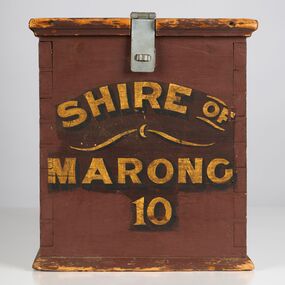 City of Greater Bendigo - Civic Collection
Functional object - Ballot Box, Shire of Marong, Shire of Marong 10, Unknown
The first local government authority for Marong was the Marong Road District (an early form of single-purpose local government), which was proclaimed on 19 August 1860. Its boundary was altered twice in 1862 and on 12 December 1864 it was re designated as a Shire. It absorbed Raywood Borough in 1915, and was proclaimed a Rural City in 1990. On 2 December 1994, with the creation of Greater Bendigo City Council, it was abolished through the amalgamation which took place between Bendigo City, Eaglehawk Borough, Huntly Shire, part of McIvor Shire, part of Metcalfe Shire and Strathfieldsaye Shire to form the City of Greater Bendigo. This box would have been used to collect votes during council elections.Wooden painted, lidded box with hinged opening lid. Central slit in lid to insert ballot papers. Front face painted in black and gold paint. Hinged at front of box with lock on back. Handle attached to the back.Front of box; Shire of / Marong / 21shire of marong -
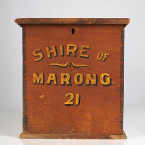 City of Greater Bendigo - Civic Collection
Functional object - Ballot Box, Shire of Marong, Shire of Marong 21, Unknown
The first local government authority for Marong was the Marong Road District (an early form of single-purpose local government), which was proclaimed on 19 August 1860. Its boundary was altered twice in 1862 and on 12 December 1864 it was re designated as a Shire. It absorbed Raywood Borough in 1915, and was proclaimed a Rural City in 1990. On 2 December 1994, with the creation of Greater Bendigo City Council, it was abolished through the amalgamation which took place between Bendigo City, Eaglehawk Borough, Huntly Shire, part of McIvor Shire, part of Metcalfe Shire and Strathfieldsaye Shire to form the City of Greater Bendigo. This box would have been used to collect votes during council elections.Wooden, painted, lidded box with hinged opening lid. Central slit in lid to insert ballot papers. Front face painted in black and gold paint. Hinged at back of box with lock on front. Front of box Shire of / Marong / 21shire of marong