Showing 1947 items matching " flooding"
-
 Orbost & District Historical Society
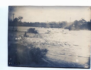
black and white photograph, January 1934
From The Argus (Melbourne) on January 10 1934 "Damage estimated at £500,000 has been caused by the floods in the Orbost district. No loss of life occurred, largely owing to the heroic efforts of rescue parties. Many families spent Monday night on the roofs of houses or in trees, surrounded by deep, rushing flood waters." This 1934 flood was devastating, destroying a section of the 1922 Orbost bridge - the centre span was washed away -. wrecking fences, bridges and roads, dumping silt and debris on the rich river flats and drowning cattle. This is a pictorial record of the 1934 flood, a significant event in the history of Orbost.A black / white photograph of floodwaters. In the middle of the water can be see debris including a large spoked wheel. In the background are houses and fences.on back - "near Hilyer's garage at foot of hill Main Street Caravan Park on right" on front at bottom left - "1934"orbost-flood-1934 flood-orbost -
 Stawell Historical Society Inc
Photograph, Paxton Street Bridge on Concongella Creek in Great Western in flood 1988-- 2 Photos
Paxton Street Bridge Concongella Creek - Great Western. Flooding 2/9/1988stawell -
 Wodonga & District Historical Society Inc
Album - Ringer's River by Des Martin - Plate 29 - Keiran drowns
A flash flood caused by the cloudburst upstream catches them all in the river and Keiran is drowned.The album and images are significant because they document literature written by a prominent member of the Wodonga community. The presentation of this precis was supported by several significant district families and individuals.Ringer's River Album Coloured photo Plate 29des martin, many a mile, ringer's river, northeast victoria stories -
 University of Melbourne, Burnley Campus Archives
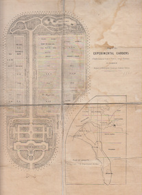
Plan, Alfred Lynch, Plan of the Experimental Gardens of the Horticultural Society of Victoria. Survey Paddock. Richmond, 1861
Subsequently the area was not fully developed in this manner following flooding in 1863. Some remnants remain.Plan on paper with cloth backing to enable folding. Inscription, "Designed by Alfred Lynch. Landscape Gardener, Prahran. Printed by De Guchy & Leigh." An inset plan shows position of Experimental Gardens related to the City of Melbourne and Bay. Plan shows layout and plantings of the designated area - fruit, vegetables: the conservatory, nursery, exhibition buildings. This plan was owned by E.E. Pescott. Inscription on cover, "Burnley. E.E.P.." "Ed. E. Pescott." Subsequently the area was not developed in this manner. See inscription on copy made for Centenary Exhibition B92.633. Other copies given to College by N. Lothian (graduated 1934). Jim Sanders, a friend of his, gave them to Dr. G. Moore in 1991. A larger copy, inscribed on reverse, '1861', 'Early proposals for Horticultural Gardens for Horticultural Society of Victoria (now Royal). The lithograph was included as an insert in the Farmers Journal and Gardeners Chronicle 21 June, 1862. It is only in one of the copies held by the State Library of Victoria. 1 large and 1 small photographs of plan. Several photocopies of the plan.Inscription, "Designed by Alfred Lynch. Landscape Gardener, Prahran. Printed by De Gruchy & Leigh." / Inscription on cover, "Burnley. E.E.P.." "Ed. E. Pescott."alfred lynch, experimental gardens, nursery, e.e. pescott, horticultural socoety of victoria, buildings -
 Federation University Historical Collection
Photograph - Colour, Leigh River near Garibaldi Bridge
The Leigh River is a major tributary and catchment of the Barwon River. Fed by the Yarrowee River that rises near Ballarat, the Yarrowee reaches its confluence to form the Leigh in the vicinity of Cambrian Hill and Golden Plains Shire. The Leigh River rises below Mount Mercer and flows generally south, joined by three minor tributaries before reaching its confluence with the Barwon River, southeast of the central business district of Inverleigh. The river descends 265 metres (869 ft) over its 61-kilometre (38 mi) course. (https://en.wikipedia.org/wiki/Leigh_River_(Victoria)Relates to historical information about flooding of the Leigh River in 1933. Relevant to the history of Garibaldi and Durham Lead.A number of colour photographs showing the Leigh River between Garibaldi and Durham Lead, Victoria, .1 - .3) photographs of the Leigh River in flood .4 - .18) general photos of the Leigh River and surrounding countryside .19) broad angle photograph of the Leigh River and surrounding countryside leigh river, garibaldi, garibaldi bridge, durham lead, vincent family -
 Bendigo Historical Society Inc.
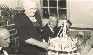
Photograph - BERT GRAHAM COLLECTION: 25TH ANNIVERSARY BENDIGO EAST ASSOCIATION
Black & white photograph, Bert Graham Collection, Mr. Jack Tully, Mrs. Tully cutting the cake, Tom Flood and Bert Graham celebrating the 25th Anniversary of the Bendigo East progress Association, on the tableare wrapped presents , sausage rolls on a plate and a bottle of tomato sauce.bendigo, clubs, bendigo east progress association -
 8th/13th Victorian Mounted Rifles Regimental Collection
Photograph
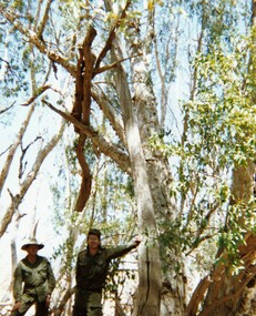
In 1988, as part of a Defence of Mainland Australian policy, defence of facilities of strategic importance in northern Australia were allocated to Army Reserve units. ‘A’ Squadron was allocated the defence of Tindal Air Force base located 15 KM outside Katherine in Northern Territory. Consequently the Squadron deployed on Exercise ‘Northern Explorer’ to gain first-hand knowledge of operating conditions for mounted and dismounted patrolling in the area.Colour photograph of Captain C. Carrington, earing hat, and Sergeant Koschel of ' A ' Squadron 8/13 VMR during Exercise " Northern Explorer." Flood debris caught high in tree branches indicate water level during wet season on Ferguson River, Northern Territory. -
 Rutherglen Historical Society
Image, c1870
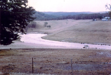
Possibly Lake King shortly after the weir was built, or Lake Moodemere or the Murray River in flood.Black and white photograph of a body of water surrounded by trees.lake king, lake moodemere, murray river -
 Ballarat Heritage Services
Photograph - Video, Clare Gervasoni, Confluence of Canadian Creek and Yarrowee River near Anderson Street, Ballarat, 06/09/2022
The waterways of central Ballarat were channeled to prevent flooding and contain sludge during the mining era.Video of the confluence of Canadian Creek and Yarrowee River near Anderson Street, Ballarat flowing down a channel.canadian creel, yarrowee river, ballarat, anderson street, channel, bluestone -
Ballarat Heritage Services
Photograph - Video, Clare Gervasoni, Specimen Vale Creek at Steinfeld Street, Ballarat, 06/09/2022
The waterways of central Ballarat were channeled to prevent flooding and contain sludge during the mining era.Video of Specimen Vale Creek at Steinfeld Street, Ballarat., Ballarat flowing down a channel.ballarat, channel, bluestone, specimen vale creek, steinfeld street -
 Charlton Golden Grains Museum Inc
Photograph, Cameron, Ian, 1973 floodwater running accross Sheepwash on Boort Road, 2/3/1973
Flood 1973, Carol Thomas' car washed of the road. At the sheep wash on the Boort Road, Charlton.B/W photograph of Carol Thomas's car washed off the road by the strong current running accross the Sheepwash on the Boort Road 1973flood, charlton, boort -
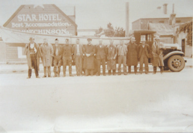 Lakes Entrance Historical Society
Photograph, H D Bulmer, Lakes Entrance fisherman rescue during 1934 floods near Sale, 1934 c
Lakes Entrance fishermen travelled to the Sale area to assist in the rescue of flood victims during 1930sSepia toned photograph of Lakes Entrance fishermen standing beside a boat on the tray of a small truck outside the Star Hotel Sale Victoriaships and shipping, floods, natural disasters -
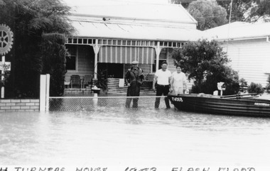 Charlton Golden Grains Museum Inc
Photograph - Photocopy
The 1973 Flood. Picture of H Turner's house in High Street with his boat tethered to the fence.Poor copy of original Photo originally used in Charlton Tribune February 23 1973 P4flood, turner -
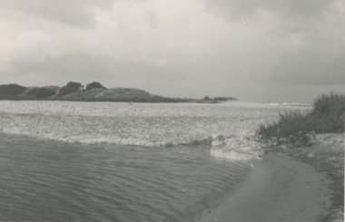 Lakes Entrance Historical Society
Photograph, Lake Bunga and ocean Victoria
Taken after a recent flood event. The ocean waters foam when it meets fresh water. Black and white photograph of the entrance to Lake Bunga Victoriaocean, waterways -
Clunes Museum
Document - REPORT
PHOTOCOPY PORTION OF REPORT OF DAMAGED WEIR AT GLENORCHY JULY 1882 WHEN WILLIAM COWLAND, WORK SUPERVISOR, AND HIS GANG WORKED DAY AND NIGHT TO REINFORCE THE DAMAGED BANKS. THE EMBANKMENT HAD BEEN BUILT SEVERAL TIMES BEFORE IT WAS FINALLY SUCCESSFUL AND WITHSTOOD THE BIG FLOOD 1883local history, pamphlet, report, cowland, history -
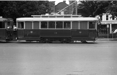 Ballarat Tramway Museum
Negative, Wal Jack, early 1960's
Yields information about tram services and the use of the City Loop and tramcars in general.Negative and Digital images of the Wal Jack Ballarat Negative file of Ballarat No. 13 in the city loop. Side on photo. Early 1960's. Tram has the blinds drawn - look new. In the background are the hotel with the proprietor J P Flood and a shop Betty Preen Pty Ltd. trams, tramways, city loop, sturt st, tram 13 -
University of Melbourne, Burnley Campus Archives
Newspaper - Newspaper Cutting, The Leader, Horticultural Notes, 1891
Copy of article in "The Leader" (Melbourne) on 22 August, 1891 p 14. Descriptions of members of the Board of Advice for the School of Horticulture and curriculum. Discussion about what to do to prevent further flood damage such as a breakwater. Mr Neilson, curator, has managed to save the young apple trees.the leader, mr neilson, curator, apple trees, school of horticulture, floods, board of advice, flood damage -
University of Melbourne, Burnley Campus Archives
Newspaper - Newspaper Cutting, The Age, Horticultural Society, 1865
Copy of article in "The Age" 20 July, 1865 p7. Description of Annual General Meeting. Grounds unfit for purpose after 1863 flood. Young stock being planted in part of Ornamental Garden. Government allowing Society to select more suitable ground near to present garden.floods, gardens, annual general meeting, horticultural society of victoria, flood damage, ornamental garden used for fruit trees, additional grant of land -
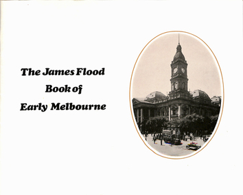 Melbourne Tram Museum
Book, H H Paynting, "The James Flood Book of Early Melbourne", 1970
Book - 36 pages including cover, centre stapled, titled "The James Flood Book of Early Melbourne", edited by H H Paynting. Contains photos of Melbourne and suburbs to the early 1900's, includes cable trams, buses railways. Has credits, other books published.trams, tramways, melbourne, cable trams, buses, railways, street views, street scenes -
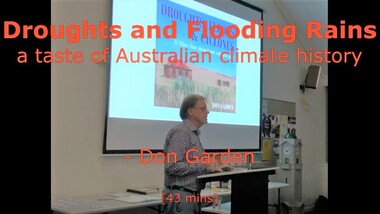 Ringwood and District Historical Society
Mixed media - Video, RDHS Guest Speaker Presentation - A Taste of Australian Climate History - Don Garden
Digitised video (2.84GB). Duration: 43 minutes. Recorded October, 2019 (Video is available for viewing at Ringwood & District Historical Society Archives by appointment)Presenter: Don Garden, OAM FFAHS, FRHSV, historian and author, examins the history of climate in Australia as researched for his book "Droughts, Floods & Cyclones - El Ninos that Shaped our Colonial Past". -
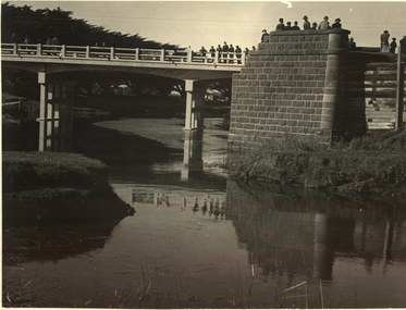 Port Fairy Historical Society Museum and Archives
Photograph, 1950
Rosebrook bridge opening - 1950PhotographOpening of Rosebrook Bridge Princes Highway, by the chairman of the C.R.B. Mr D.V. Davison? om thursday the 15th of June 1950 Bluestone abuttments of old bridge washed away by floods in 1946 in the foregroundnew rosebrook bridge - opening, 1950, bridge, opening -
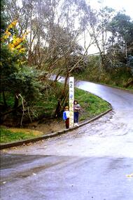 Greensborough Historical Society
Slide - Photograph, John Ramsdale, Ford over Plenty River at Partington's Flat: Slide 52, 1990s
Photograph shows 2 children with flood height marker at the ford over Plenty River at Partington's FlatPart of the John Ramsdale collection of slides and audio visual material.Colour photograph scanned from slide.No maker's marks. No caption on slide.partingtons flat, ford over plenty river, plenty river -
Tatura Irrigation & Wartime Camps Museum
Document - Folder, Tatura Historic Events 1950's
Collection of photographs of events in Tatura. 1950's Royal Tour, Buildings, Floods, Turaton and Templer Choir.Plastic burgandy binder, black spine, white label, blue writingTatura Historic Events 1950's Photos. James Lallytatura historic events, tatura, tatura museum, documents, history, local -
Tatura Irrigation & Wartime Camps Museum
Photograph, Research Station
Research Station, now Institute for Sustainable Irrigation.|Tatura Trellis.|Floods in orchard 1939, 1955 and 1974photograph, people -
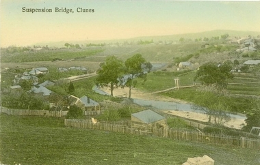 Clunes Museum
Photograph - POSTCARD, PRINTED IN GERMANY, SUSPENSION BRIDGE, CLUNES
THE SUSPENSION BRIDGE OVER CRESWICK CREEK, PLACED AT CREEK PARADE CLUNES, WAS WASHED AWAY IN A SEVERE FLOOD.COLOURED PHOTOGRAPH OF SUSPENSION BRIDGE CLUNES. PRODUCED AS A POSTCARD - 2 COPIES. ANOTHER COPY HAS BEEN ENLARGED TO A4 SIZE AND LAMINATED - 760.2SUSPENSION BRIDGE - CLUNESlocal history, document, postcard, bridges -
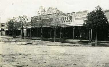 Charlton Golden Grains Museum Inc
Photograph, Flood 1911, c.1911
Flood 1911. High St Charlton showing Golden Fleece Hotel and W. Wylie General StoreSmall black & white snapshot showing Golden Fleece Hotel and W. Wylie General Store. Two children standing on the footpath. Water on the road in front of them. charlton, flood, willey, willey store -
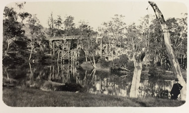 Kew Historical Society Inc
Photograph - Demolishing the Zig-Zag Bridge, 1929
Henry Beater Christian (1886-1962) , was a descendant of one of the earliest settler families in Kew. Employed at the Kew Asylum as a 'public servant', he was a skilled amateur photographer, photographing numerous scenes in Kew and on his travels around Victoria. The majority of his photographs date from 1916 to 1929. His finest photographs are housed in two photograph albums. Rare photograph of the demolition of the Zig-Zag Bridge linking the two asylums on either side of the Yarra River.Digital copy of a photograph from page 16 of the 47-page photograph album containing 261 gelatinous silver images, loaned by Diane Washfold with permission given to digitise and hold a copy in our collection. The Zig-Zag Bridge linked the grounds of the Yarra Bend and Kew Asylums. The wooden bridge was constructed in the 1870s and lasted through numerous floods until its destruction in 1929. A horizontal structure, the walkway was reached via a wooden staircase on the Kew bank of the river. The steps were required due to the different levels of the banks on this stretch of the river. This is a photo of the bridge before part of it was destroyed in a flood in 1929. A man, perhaps Henry Christian, stands at the right of the foreground."Demolishing Zig-Zag / 6. 1929"henry beater christian (1886-1962), landscape photography, kew (vic.) — yarra river, christian-washfold collection, photograph albums, zig-zag bridge -
 Bendigo Historical Society Inc.
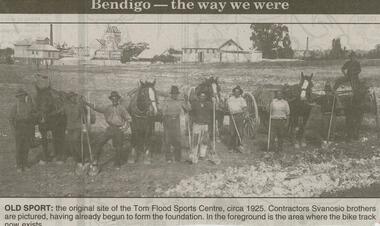
Newspaper - JENNY FOLEY COLLECTION: OLD SPORT
Bendigo Advertiser ''The way we were'' from 2000. Old spot: the original site of the Tom Flood sports centre, circa 1925. Contractors Svanosio brothers are pictured, having already begun to form the foundation. In the foreground is the area where the bike track now exists. The clip is in a folder.newspaper, bendigo advertiser, the way we were -
 Bendigo Historical Society Inc.
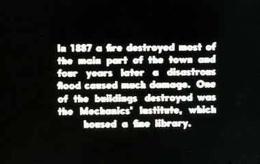
Slide - DIGGERS & MINING. DIGGERS AND MINERS, 1850s
Diggers & Mining. Diggers and Miners. In 1887 a fire destroyed most of the main part of the town and four years later a disastrous flood caused much damage. One of the buildings destroyed was the Mechanic's institute, which housed a free library. Markings: 48 994.5 WAL. Used as a teaching aid.hanimounteducation, tertiary, goldfields -
 Bendigo Historical Society Inc.
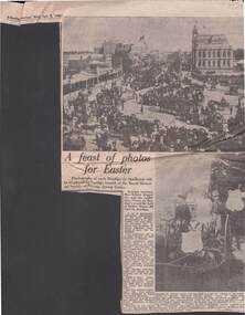
Newspaper - 1980 NEWSPAPER ARTICLE: THE DISPLAY OF EARLY BENDIGO PHOTOS BY THE ROYAL HISTORICAL SOCIETY
2.4.1980 newspaper article re the display of early Bendigo photos by the Royal historical society .Photos shows Easter Parade photos .The top photo show crowds lining Pall Mall and flooding into Howard Place in 1898. The bottom photo was taken at an Easter procession during the 1890'snewspaper, bendigo advertiser, newspaper column