Showing 1297 items
matching -1852. | briggs
-
 Uniting Church Archives - Synod of Victoria
Photograph, Undated c.1890
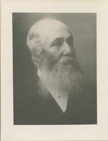
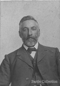
Rev. Francis Robert Muter Wilson was born in 1832 near Hamilton, Lanarkshire, Scotland. He entered Edinburgh University in 1848 and started theological studies in 1852 at New College Edinburgh. He completed theological studies in 1856 and arrived in Melbourne in September 1857. He briefly preached to a small congregation at Brighton, and then early in 1858 he supplied the pulpit of Dr. McKay in Sydney. Later in 1858 he received a call to Camperdown and was ordained there in December 1858. Married Lillie Tait in Geelong in April 1861. Moderator of the Presbyterian Church of Victoria in 1875. Called to Kew in 1877 and served there until he was demitted in 1898. Convenor of the Business Committee of Assembly. Died June 9 1903.B & W head and shoulders studio portrait of Rev Francis Robert M. Wilson, printed on buff card.Rev. F.R.M. Wilson 1876 - 1897francis robert muter wilson, presbyterian, minister, edinburgh, kew, moderator -
 Kew Historical Society Inc
Work on paper - Sepia Wash & Ink, G B Richardson, Creek and Old Watering Stage, on the Yarra, East Collingwood, 1854, 1854
Blind Creek was located between the Abbotsford Convent and what is now the Collins Bridge in Studley Park. In an 1858 map of East Collingwood by Clement Hodgkinson, in the State Library of Victoria, one can see how the creek was originally a significant landmark in Collingwood; remaining vacant land until a barrel drain enclosed it. The area was later filled in, surveyed and developed. The position where Blind Creek entered the Yarra was in the immediate vicinity of Hodgson’s Punt, which had linked Kew to the other side of the Yarra from 1839. The Punt was purchased by the Colonial Government in 1852 and was in use until the opening of the Studley Park Road (Johnston Street) Bridge in 1858 made its continued use redundantThe point of view selected by the artist for the watercolour is from the banks of Blind Creek in East Collingwood, looking across the Yarra to the Kew side of the river.Inscribed verso 'Creek and Old Watering stage, on the Yarra East Collingwood 1854 / Trees, stage, &c have long since disappeared / [Artist Signature] / FT 110 / Creek itself now being filled in 1903.gb richardson, blind creek - abbotsford, yarra river - abbotsford (vic) - kew (vic), colonial artists, australian art - 19th century, george bouchier richardson -
 Bendigo Historical Society Inc.
Document - BARBARA MAMOUNEY COLLECTION: COPY OF PRINTED PAGE
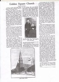
Photocopy of a published page, marked as Eightieth Anniversary, relating to records as showing Golden Square as the first place in the Bendigo area at which the gospel was preached. On arriving from South Australia in 1852, attracted by the news of gold in the area James Jeffrey widely known later as Jimmy Jeffrey, a preacher who noticed that the sanctity of the Sabbath was being ignored, with normal chores and entertainment being the order of everyday. In short, little regard was shown for religion and there were no ministers. With a tree stump as his pulpit Jimmy began service by singing a Methodist hymn heartily, attracting a band of diggers to listen, with continuous services in Golden Square taking place ever since. Jeffrey continued with similar activities with increasing interest and attendances. Beginning with a tent surrounded by a fence a disused shed was bought and relocated to the site and was the finest building in the district. Late in 1852 the first real Church was erected in place of the shed and the tent. Enthusiasm and numbers of attendees swelled and in 1859 Reverend Joseph Dare and Robert Lisle and other church leaders purchased land (for 30 pounds) and had the foundation stone for a new Church building was laid by Reverend Daniel J.Draper on19th of April 1859 with Divine Service and Public Worship conducted from 11th December that year by Reverend Mr Draper. A collection on the day raised 262 pounds. The foundation stone for the present Church was financed by Richard Allingham laid on 5th January 1870. The first minister who went to the district was Reverend Mr Symonds who was stationed at Forest Creek near Castlemaine. Reverend Richard Hart was the first minister stationed at Golden Square. Embedded in the article is an image of Jimmy and Mrs Jeffrey. On the reverse of the article is a copy of a drawing by Reverend Aswel Aptel circa 1853.fra margolden square methodist church, wesleyan church, mamouney, church, richard allingham reverends jimmy jeffrey, william robert lisle robert draper, william taylor, symonds, j dare, chapman, hilson t raston, richard hart, wm shaw. g a pethard, robert saunders. reverse side a sketch of the church circa 1853 by aswel aptel. james cox (sec) mrs foot (teacher). -
 The Beechworth Burke Museum
Photograph - Photograph - Reproduction, Unknown c1852-1940
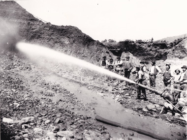
Depicted in the photograph are ten miners standing at a cliff face using a high pressure hose, in Beechworth, Victoria. The miners are located in the Three Mile Creek division, in the Beechworth Mining District established January 4th 1858 under An Act for Amending the Laws Relating to the Goldfields by the Governor-in-Council. The Ovens Gold Rush began at Beechworth in February 1852 and was followed by Yackandandah and the 'Indigo Goldfield'. The strategies applied to mining in Beechworth were distinct in comparison to other goldfields in Victoria such as Bendigo and Ballarat. The miners in Beechworth utlised 'hydraulic sluicing' to remove washdirt, the long water races and deep tailraces constructed through solid rock with an estimated 900 miles of water races cut through the Beechworth fields by 1880, demonstrating great engineering feats. The photograph taken is significant as it is a visual representation of the mining strategy, 'hydraulic sluicing' that was particularly unique to the Beechworth mines, particularly in Victoria and an engineering feat.Black and white rectangular photograph printed on matte photographic paper, unmounted print.beechworth mining district, mining, three mile creek division, three mile creek -
 Eltham District Historical Society Inc
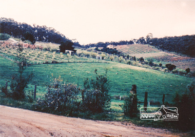
Photograph, Bird family Orchard, Pitt Street, Eltham, c.1980s
View looking northeast from near junction of Wattle Grove and Mount Pleasant Road across to Eucalyptus Road on right and Pitt Street at top. Early pioneer, George Bird Snr. arrived from England in 1852 and lived with his uncle, George Stebbing. He worked for him as bricklayer's assistant in building, among others, the Anglican and Methodist Churches in Eltham. In 1862 he purchased land in the east end of Pitt Street bounded by Eucalyptus Road and Wattle Grove and established a mixed farm and orchard. His son, Arthur Bird succeeded him and also worked on this orchard which then passed to Arthur's son, Harold Bird OAM, where Harold and Yvonne Bird lived in the family home till the mid 2000s A4 size photographic print reproduction of a paintingaos6, wattle grove, pitt street, arthur bird, bird family orchard, eucalyptus road, george bird, harold bird, yvonne bird, eltham -
 Eltham District Historical Society Inc
Photograph, Bird family Orchard, Pitt Street, Eltham, c.1980s, 1980s
View looking northeast from near junction of Wattle Grove and Mount Pleasant Road across to Eucalyptus Road on right and Pitt Street at top. Early pioneer, George Bird Snr. arrived from England in 1852 and lived with his uncle, George Stebbing. He worked for him as bricklayer's assistant in building, among others, the Anglican and Methodist Churches in Eltham. In 1862 he purchased land in the east end of Pitt Street bounded by Eucalyptus Road and Wattle Grove and established a mixed farm and orchard. His son, Arthur Bird succeeded him and also worked on this orchard which then passed to Arthur's son, Harold Bird OAM, where Harold and Yvonne Bird lived in the family home till the mid 2000s A4 size photographic printaos6, wattle grove, pitt street, arthur bird, bird family orchard, eucalyptus road, george bird, harold bird, yvonne bird, eltham -
 Queenscliffe Maritime Museum
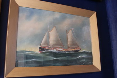
Painting - Water colour painting of the ketch Falie, Falie, 1934
Arthur V Gregory b.1867, d.1957 worked from studio at 326 Albert Road South Melbourne established by his father G F Gregory in 1852. FALIE operated for many years as a cargo ship, largely around South Australia where it formed a strong regional association. During World War II, FALIE was requisitioned by the Royal Australian Navy for service, and was on patrol off Sydney Heads during the mini-submarine raid on Sydney Harbour in May 1942. After the war it returned to commercial service and was retired in 1982. It was then the last working ship representing the South Australian ketch fleet, and along with NELCEBEE ( HV000419) one of the last two working sail powered cargo vessels in South Australia.Water colour painting in painted gilt frameFalie off Cape Schank A.V. Gregory 1934falie, a.v. gregory, water colour, painting -
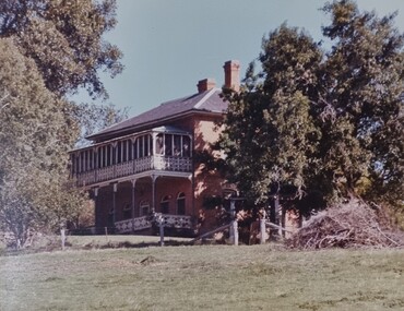
 Kew Historical Society Inc
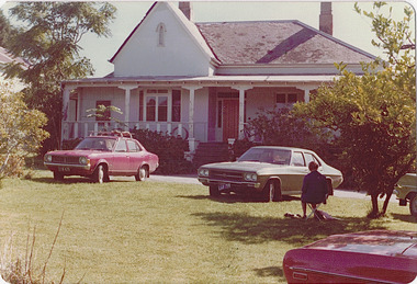
Photograph - 'Neama', Studley Park Road, 1978
Edward Augustus Atkyns was born in Wiltshire, England in 1840. His family emigrated to Australia in 1852. As a young man he was a keen cricketer and played at the first cricket ground in the district, located between Barkers Road and Hawthorn Grove, on the site of the future Barker railway station. Atkyns was admitted to the Victorian Bar in 1861, initially working in his father’s practice. He sat as a local magistrate in both Kew and Hawthorn and acted as solicitor for several shire councils. Elected to the Hawthorn Borough Council in 1863 at the age of 23, he served in that municipality as mayor in 1866-67. By 1877, he had moved to Kew where he lived at Neama in Studley Park Road, a property later incorporated into the St Paul’s School for the Blind.Rare colour photograph of what was once a significant house in Kew.Original colour positive photograph (Kodak print) of the main house of 'Neama', colloquially known as the 'farmhouse'. Photographed by Stewart West in April 1978 (it was later demolished by the Villa Maria Society).Annotated reverse: "Front view of Neama / Farmhouse on St Paul's School for the Blind Children / Fernhurst Estate"st paul's school for the blind, neama, studley park road -- kew (vic.), historic houses -- kew (vic.), villa maria society -
 Kew Historical Society Inc
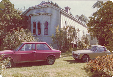
Photograph - 'Neama', Studley Park Road, 1978
Edward Augustus Atkyns was born in Wiltshire, England in 1840. His family emigrated to Australia in 1852. As a young man he was a keen cricketer and played at the first cricket ground in the district, located between Barkers Road and Hawthorn Grove, on the site of the future Barker railway station. Atkyns was admitted to the Victorian Bar in 1861, initially working in his father’s practice. He sat as a local magistrate in both Kew and Hawthorn and acted as solicitor for several shire councils. Elected to the Hawthorn Borough Council in 1863 at the age of 23, he served in that municipality as mayor in 1866-67. By 1877, he had moved to Kew where he lived at Neama in Studley Park Road, a property later incorporated into the St Paul’s School for the Blind.Rare colour photograph of what was once a significant house in Kew.Original colour positive photograph (Kodak print) of the secondary building at 'Neama', colloquially known as the 'hall'. Photographed by Stewart West in April 1978 (it was later demolished by the Villa Maria Society).Annotated reverse: "Timber hall on Fernhurst land / Transported there approx 1878."st paul's school for the blind, neama, studley park road -- kew (vic.), historic houses -- kew (vic.), villa maria society -
 Melton City Libraries
Photograph, Thomas Lang, 1905
Born on the 22nd October 1852 or 1849 St Ives Cornwall, in 1896 Thomas and Mary Elizabeth moved to Melton. Mr Lang’s previous school was Coliban SS No 1920. Mr Lang was the Head Teacher at Melton until 1917. In 1910 he was a Committee Member Melton Mechanics Institute and Public Library atits establishment. He was a Life Member of the Melton Mechanics Institute In 1875, he married Mary Elizabeth Coates on the 30th December at the home of Mrs Coates, Thomas Lang of Norton’s Creek aged 26 andMary Elizabeth aged 24 of Armstrongs. They had 9 children, Thomas.J. Lang, George William, Jessie, Maude, Effie, Walter, Horace, Eva and James. Passed away in 1927. Black and white photo of Langlocal identities, education -
 Wodonga & District Historical Society Inc
Map - Tulloch & Brown's Map of the Colony of Victoria, Tulloch & Brown, 1856
The map was created by Tulloch and Brown. David Tulloch was one of the earliest engravers and lithographers in the state of Victoria. He arrived in Melbourne from Greenock, Scotland, on 3 January 1849. Following the discovery of gold Tulloch went to the Victorian goldfields in 1851, commissioned to make sketches of the diggers and the diggings for Ham’s Illustrated Australian Magazine. In November 1852 Tulloch set up in business as engraver, draughtsman, copperplate printer and lithographer. Tulloch took a map engraver, James Davie Brown, into partnership in March 1853; the several maps and specimens of commercial engraving they showed at the 1854 Melbourne Exhibition were awarded a bronze medal. That year Tulloch and Brown also received a silver medal at the Victorian Industrial Exhibition. The partnership was dissolved towards the end of 1856.This is a very early map of the Colony of Victoria including Belvoir (now know as Wodonga).A foldable map mounted on linen and with a board cover. It records the Colony of Victoria according to Surveyor's Records revised in 1857. Areas of the map are shaded to highlight different counties.At bottom right hand section of map: Tulloch & Brown's map of the Colony of Victoria : comprising part of New South Wales, the boundaries, counties, also seaport & inland townships, the gold fields with the latest discoveries, roads, tracks, &c. &c. / compiled from drawings in the Survey Office and correctly revised till 1857. Respectfully dedicated by Permission, to the Honorable Captain Andrew Clarke R.E. Surveyor General of Victoria by His Obediant Servants Tulloch & Brown, Engravers & Publishers, Melbourne". At bottom right below border : Published as the Act directs by the Proprietors, Melbourne, 1st Feb. 1856. tulloch and brown maps, rare maps victoria, victorian cartography -
 Eltham District Historical Society Inc
Photograph, Fay Bridge, Eastern boundary of former Warrandyte Aboriginal Reserve, North Warrandyte, 7 November 2016
Two bronze commemorative plaques on rocks, unveiled by Wurundjeri Tribe Council Elders, mark two eastern boundaries of the former Warrandyte Aboriginal Reserve on the north and south sides of the Yarra. This project was initiated by Nillumbik Reconciliation Group in close association with Reconciliation Manningham and the Wurundjeri Tribe Council, as a means of commemorating the last great corroboree of the Kulin Nation which was held at Pound Bend in March 1852. This plaque is on the Nillumbuk side of the Yarra, accessed via The Boulevard, North Warrandyte. The plaque is set on a rock approximately 50 metres before the turning circle at the end of The Boulevard. Plaque : Warrandyte Aboriginal Reserve This commemorative rock marks an eastern boundary of the former Warrandyte Aboriginal Reserve established in 1852. Centred on Pound Bend, it covered 1,908 acres on both sides of the Yarra River (Birrarung). That same year saw the last great gathering of the Kulin nation here in Wurundjeri country which was celebrated over two weeks with traditional performance and games. For a few years longer the reserve intermittently served as a ration station.With gold having been discovered at Warrandyte, the Wurundjeri were moved on again but ultimately secured a permanent home at Coranderrk, Healesville. A second commemorative plaque and rock is located on the opposite bank of the Yarra and its confluence with Stony Creek. Melway ref : 23 C 9 Unveiled by Wurundjeri Elder, Uncle Bill Nicholson on 23rd March 2013 Funded by the Robert Bridgford Indigenous Trust (Nillumbik Community Fund) with assistance from Manningham City Council Small Grants Program Ref: Monument Autralia https://monumentaustralia.org.au/themes/culture/indigenous/display/99680-warrandyte-aboriginal-reserve-fay bridge collection, 2016-11-07, aboriginal reserve, north warrandyte, plaques, warrandyte aboriginal reserve -
 The Beechworth Burke Museum
Photograph
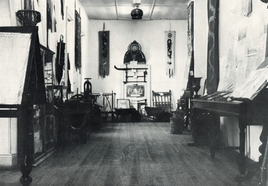
This black and white photograph is estimated to have been taken c1900 inside the Burke Museum. Several objects part of the museum collection at the time can be seen, with a high number of Asian influence objects visible; potentially Chinese in origin, as several Chinese villages were located around Beechworth and across Spring Creek, from the mid 1800s. The Burke Museum is part of the Precinct of Beechworth, which was established upon the discovery of gold in 1852. Originally built as the Beechworth Athenaeum in 1857, the museum was later renamed to the Robert O'Hara Burke Memorial Museum, more commonly known as the Burke Museum, in honour of the famous explorer and former Beechworth Superintendent of Police, Robert O'Hara Burke, after his death in 1861 at Coopers Creek during the famed ill-fated Burke and Wills expedition.This photograph is contextually, historically and socially significant due to its connection to both the Burke Museum and Chinese culture in and around Beechworth during the mid-1800s through to 1900s. Around 4700 people of Chinese heritage lived at the Ovens goldfield by April of 1857, representing one-quarter of the entire population at the time. The object holds strong representativeness to the history of the Burke Museum and to the objects in its collection. Its interpretive capacity could be supported and enhanced with other photographs and objects in the collection. Collectively, these records and objects could provide an insight into the museum's collection and its relationship with the origins of the objects.Black and white rectangular photograph printed on paper. Unmounted; taped to paper. beechworth, spring creek, chinese, burke museum, immigration, chinese immigration, ovens goldfield, china, museum, robert o'hara burke, burke and wills expedition, burke and wills, goldfields -
 Orbost & District Historical Society
bottle, Probably WW11
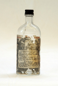
Joseph Bosisto was a Yorkshireman who had qualified as a Pharmacist in Leeds and London. He arrived in Adelaide in 1848 at the age of 21. In 1851 he moved to Victoria in search of gold, but instead opened a pharmacy in Richmond, where he built a laboratory to investigate the chemical and medicinal properties of Australian plants. As a result of the collaboration with von Meuller the essential oil industry of Australia began in 1852, when Bosisto commenced operations in a small, rudely constructed still at Dandenong Creek, Victoria, using the leaves of a form of E. radiata (then known as E. amygdalina) which grew profusely in the district. Bosisto soon built other distilleries at Emerald, Menzies Creek and Macclesfield. World War II soldiers packed it in their mess kits to keep foot fungus in the tropics at bay. Small clear glass Eucalyptus Oil bottle with metal screw lid and large label on front.Front Label - War Time Pack Back - This bottle remains property of J Bosisto &Co Pty Ltd Richmond Victoria Bottom-F1196bottle eucalyptus-oil bosisto-joseph -
 The Beechworth Burke Museum
Photograph, unknown
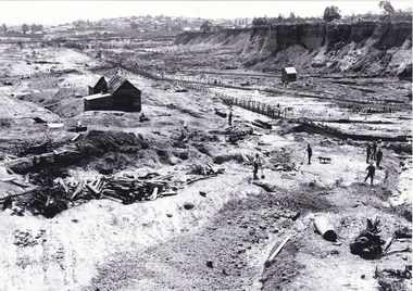
This reproduced photograph is of Pennyweight Flat near Beechworth, a notable area of the 1850's gold rush in Victoria. Donald Fletcher, migrating to Beechworth from Scotland in 1855, had substantial claims at Pennyweight Flat and was amongst the first in the district to utilise hydraulic sluicing and water diverting methods.The flat is said to have seen a flurry of 200 miners to the area around 1857, and by 1861 when work commenced on extending Fletcher's tail race the census recorded 644 people residing there (European males, females and Chinese). Pennyweight Flat is also significant for the cemetery that resides on the hilltop and which noted approximately 200 burials from the gold rush period 1852-1857, known for a long period as a children's cemetery due to the number of children's graves present.The search for gold is ingrained into the history of Victoria and therefore, images like this one which portray an open cut sluicing site can reveal important information for society and technology for the date when the photograph was taken. This image is of important historical significance for its ability to convey information about sluicing and the methods used to find gold in 1910. It also shows a location where sluicing was undertaken which provides insight into the impact of sluicing on the environment at a time when it was done. This image is important for current research into the history of Beechworth and surrounding area including Victoria's North East. The Rocky Mountain Extended Gold Sluicing Company was a long running and very active mine that was one of the most successful and largest in the district. Therefore, this image has the capacity to be beneficial for research into society and the motivations of those living and working in this region during this period and therefore, has social significance. The Beechworth Burke Museum has additional images relating to gold sluicing which can be analysed and studied alongside images like this one. When the mine closed in 1921, in a liquidation sale, Zwar purchased the tunnel and clear water supply that ran under the town of Beechworth. He directed the water to his tannery and over time built a major industry in leather works that was a major employer in Beechworth. In growing his leather business, Zwar installed crude oil engines for electricity in his factory. He oversaw working with local council to introduce electricity to Beechworth via a sub-station on Albert Street. In 1927 Electric street lamps replaced gas lamps in the streets of Beechworth. Black and white rectangular reproduced photograph printed on glossy photographic paperObverse: Reverse: 84.222.5/ digital print/ rocky mountain extended gold sluicing company, gold, sluicing, gold sluicing, hydraulic sluicing, gold mine, open cut mining, mining, gold mining, north-east victoria, beechworth, burke museum -
 The Beechworth Burke Museum
Photograph, 1865
Taken in Beechworth 1865, this photograph depicts the view of the Spring creek with the Beechworth township in the background. This photograph was taken 13 years after the discovery of Gold at Spring Creek. Within eleven months of the discovery in 1852, over 8000 hopeful prospectors had descended on the region, transforming the seemingly undisturbed land into what a visiting journalist in 1880s referred to as; "A Titan's Field". Huge mounds of earth were churned by hundreds of miners in search for gold, almost every available resource the land had to offer was used for something; even the bark off the gums were stripped to line huts and shafts. By 1857 more than 20,000 people lived in Beechworth, and with this influx the town prospered with the building of numerous churches, banks, schools, shops and hotels along with a prison and hospital.Black and white rectangular photograph. Image is printed on matte photographic paper and is mounted on cardboard.Obverse: NO INSCRIPTION Reverse: BMM6925 / BEECHWORTH FROM SPRING CREEK 1865 beechworth, spring creek, gold rush, titan's field, 1865, prospectors -
 Warrnambool and District Historical Society Inc.
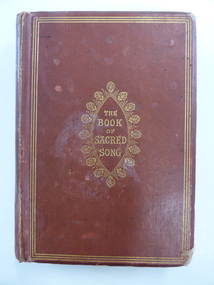
Book, The book of sacred song, 1864
This book has been given to John Ardlie by Lewis Gilles in 1866. John Martin Ardlie came to Warrnambool in 1852 as the Clerk of Courts and remained in this position until 1868. He died in 1872. He was a leading figure in community affairs for twenty years and Ardlie Street in Warrnambool is named after him. His family home was Wyton, site of the old convent at Emmanuel College today. Lewis Gilles, important in the early history of Tasmania as a bank owner and breeder of cattle, came to Warrnambool in 1854 as the first resident Police Magistrate. He remained until 1866 when he went to England (the occasion of his presentation of this book to John Ardlie). He died in 1884 in South Australia. Gilles Street in Warrnambool is named after him.This book is of high significance because of its connection to two very important early residents of Warrnambool – John Ardlie and Lewis Gilles. This is a hard cover book of 336 pages. The cover is brown with gold ornamentation and lettering on the front cover and spine. The pages are gilt-edged. The first letter of each hymn is ornamented and there is an illustration covered with tissue paper on the first page. One page shows silverfish damage and the cover is partly detached from the binding. The cover is frayed in places and a little stained. The inscription is handwritten in black ink. ‘Presented to J. M. Ardlie by his friend and comrade L.W. Gilles 1864 Worthing Sussex on departing from Warrnambool 4 May 1866’. john ardlie, lewis gilles, history of warrambool -
 Flagstaff Hill Maritime Museum and Village
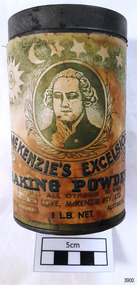
Container - Tin, McKenzies Foods, circa 1930s
This tin once contained McKenzie’s baking powder, a cooking ingredient. It was donated with other similar tins that were used by the donor’s mother who was married in 1932. It those times in Australia all manner of household items, including food and drink, were sold by hawkers (salesmen) who travelled from door to door in both suburban and rural areas. The donor remembered the bicarb soda tin on her mother’s pantry shelf. The McKenzie’s Baking Powder label adds the information that the ingredients were “Prepared with Aerophos, Regd. Trade Mark, the finest raising ingredient. A product of Albright & Wilson, Australia Pty. Ltd.” It also says that it “Excels all others in use”. The company began in Melbourne in 1852 and continues today, now run be the fifth generation of descendants from the original owners. This tin originates in the early 1900s from an Australian company that is now managed by fifth generation descendants of the original family after its inception in 1852. The tin increases in significance for its use as a recognised object found in many Australian kitchens since early days. It gives a snapshot into domestic life and social norms of the pre and post war period in Melbourne The tin is significant for its association with a local family in the 1930s for the preparation of family meals. Tin container, cylindrical, with cream and green paper label with gold highlights, motif and text. Used for selling McKenzie’s Excelsior baking powder. Container has push-on lid. Quantity of 1LB. NET. Made in Australia by McKenzie Ltd.Text includes “CLIFFORD LOVE, McKENZIE PTY. LTD.” “McKENZIE’S EXCELSIOR / BAKING POWDER”. Motif: man’s portrait within oval frame with wheat sheaf border, placed below figures of sun, moon and stars. Information and instructions. flagstaff hill asset, baking powder tin, container, flagstaff hill museum, kitchen item, cooking ingredients, flagstaff hill, warrnambool, shipwrecked coast, flagstaff hill maritime museum, maritime museum, shipwreck coast, flagstaff hill maritime village, great ocean road, tin, cooking ingredient, food container, grocery, cookery, rising agent, baking powder, mckenzie, mckenzie foods -
 Glen Eira Historical Society
Document - Banks in Caulfield
This file contains two items. 1. A hand written list of branches of the English, Scottish and Australian Bank Limited and its merger the Australia and New Zealand Banking Group Limited, undated and author unknown. The list records the opening dates of branches in Carnegie, Caulfield East, Caulfield South, Elsternwick, Glen Huntly, Murrumbeena, Ormond, Garden Vale, Caulfield and Caulfield West encompassing years from 1886 to 1927, listing also the merger of the two banks as being in 1970 as well as 1852 as being the founding year of the English, Scottish, and Australian Bank Limited. 2. Three identical Elsternwick State Savings Bank withdrawal slips, from the 1910s. All three are blank, and include brief directions for filling in the slip typed at the bottom. Also included on the slip is a decorative illustration.banks, banks mergers, bank deposits, bank withdrawals, documents, banking, pass books, business and finance, annual reports, bank equipment, commercial equipment, bank branches, carnegie, carnegie koornang road 86, caulfield east, caulfield east derby road 9, caulfield south, caulfield south glen huntly road 790, elsternwick, elsternwick glen huntly road 324, elsternwick glen huntly road 426, glen huntly, glen huntly glen huntly road 1173, murrumbeena, murrumbeena murrumbeena road 59, ormond, ormond north road, ormond north road 553, garden vale, caulfield, caulfield west, caulfield hawthorn road 242, commercial establishments, the state savings bank of victoria, the state savings bank of victoria elsternwick branch, the english scottish and australian bank limited, the australian and new zealand bank limited, the australian and new zealand banking group limited -
 City of Moorabbin Historical Society (Operating the Box Cottage Museum)
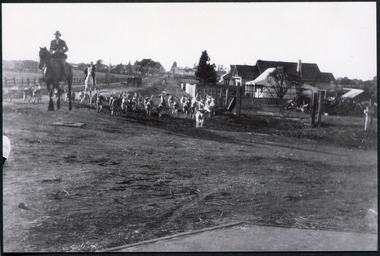
Photograph, Black & White Oakleigh Hunt Club in Jasper Rd c 1920, c1920
The Melbourne Hunt Club was founded by Mr George Watson in 1852 with hounds brought to Australia from Ireland and moved its headquarters a number of times as the city grew between 1897 and 1929, The kennels were originally at Kirk's Bazaar, in Bourke Street, Melbourne, subsequently they moved to St Kilda, Caulfield, Deer Park, Oakleigh, Cranbourne and finally to their current location in Packenham. Oakleigh was the favoured spot, mainly because of the railway and the unloading ramp at the station. Riders and horses arrived on special trains and hunted over the surrounding market gardens, but not without friction. After 1929, significant numbers of Hunt Club members had access to motorized horse transport and besides, Oakleigh was becoming too built up. The Hunt Club moved on to Cranbourne The club maintains the oldest continual pack of hounds in Australia. The Melbourne Hunt Club was founded 1852 by George Watson and imported foxhounds from Ireland. As the Melbourne suburbs spread the Club moved several times. 1920 it was in Oakleigh and now is possibly situated in Packenham Black & White photograph showing men riding horses with a pack of hounds coming down a dirt road . Houses and vacant land in backgroundwatson george, oakleigh, melbourne hunt club, smith j l; smith mary ann, stanley helen, smith vic, smith harry redvers, chaff cutter, horse drawn carts, toll gates brighton, motor cars 1900, steam engines, early settlers, bentleigh, parish of moorabbin, city of moorabbin, county of bourke, moorabbin shire, king richard, charman s, highett william, ormond francis, maynard dennis, market gardeners, vineyards, orchards -
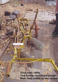 City of Moorabbin Historical Society (Operating the Box Cottage Museum)
Tool - Farm Machinery, Horse-drawn Furrow Plough, Early 20th Century
Late 1800s-early 1900s A horse-drawn furrow plough is an example of the type of farm implement widely used by pioneer market gardeners in the Moorabbin Shire following 'Dendy's Special Survey' of 1841 and the Crown Land Sale in 1852. Land allotments were bought by pioneer settlers who established or rented allotments for market gardens in the area. They supplied produce to the markets in St Kilda and Melbourne. During the gold-rush of the 1850s the rapidly increasing population of Melbourne saw a huge demand and a rise in prices for all foodstuffs, including the vegetables and fruit grown in the Shire of Moorabbin. This heralded a time of prosperity for market gardeners, and an equally rapid expansion of the numbers of vegetable and produce growers in the area. The 'knock-on effect" resulted in an increased interest and development of the community in the Shire of Moorabbin.Following 'Dendy's Special Survey' of 1841 and the Crown Land Sale in 1852, land allotments were bought by pioneer settlers who established or rented allotments for market gardens in the area and they supplied produce to the markets in St Kilda and Melbourne. During the gold-rush of the 1850s the rapidly increasing population of Melbourne saw a huge demand and a rise in prices for all foodstuffs, including the vegetables and fruit grown in the Shire of Moorabbin. Circa late 1800's to early 1900s. A horse-drawn furrow plough was the most common type of agricultural implement used by the pioneers of the 1800s and continued on into the 1940s when motorised tractors came into use. This plough is an example of a two furrow, mullboard plough which would most likely have been pulled by two horses. The long handle was used to lower the silver plates, (mullboards), to the chosen depth of soil. Painted yellow. Although this Box Cottage museum plough is unbranded, the most widely used plough in the Shire of Moorabbin was made by Oliver. This plough appears to be identical to that brand. brighton, moorabbin, pioneers, fruit, bentleigh, vineyards, vegetables, plough, market gardens, plow -
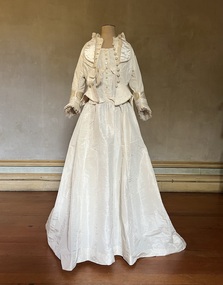 Kew Historical Society Inc
Clothing - Ivory silk and satin wedding dress and jacket, 1876-1944
Alice Henty (1852-1932) was the third daughter of Francis and Mary Ann Henty. her father was the youngest son of Thomas Henty, who with his family, their retainers and property moved to the Australian colonies between 1829 and 1832. In 1834, Francis’ older brother, Edward, sailed from Launceston in Van Diemen’s Land to what was to become Portland in the western part of Port Phillip District [Victoria]. Francis, together with the first flock of Merino sheep [in Victoria], followed some months later. The first and second generations of the Henty family established vast pastoral properties in the Western part of the Port Phillip District. Francis Henty managed ‘Merino Downs’ near Casterton, while also living with his wife following his retirement at ‘Field Place' in Kew. The Henty Collection of nineteenth and twentieth century clothing, including outerwear and underwear, was collected, stored and exhibited over time by female family members descended from Francis and Mary Ann Henty. During the twentieth century, items from the collection were modelled in two fashion parades by various descendants [1937, 1959]. The items in the collection are historically and aesthetically significant, with provenance provided by oral and written tradition within or held by the family. A number of the items in the collection are very rare survivors, and provide researchers with the evidence needed to reconstruct the lives of notable women in the Port Phillip District [later Victoria] during the nineteenth and early twentieth century.Alice Henty’s wedding dress, made in 1876 for her marriage to John Hindson was remodelled in 1943 for the wedding of her granddaughter, Alice Henty Hindson to Norman Lithgow Tait at Holy Trinity, Kew. It was worn again by Margaret Henty Hindson (1918-2000) at her marriage to Dougald Webster Matheson at St Paul's Church, Henty in 1944. The two piece dress has a low décolletage shaped with a collar from which two curved panels drop. The fastenings for the bodice are buttons covered with the same fabric. The bodice is completed with two full length sleeves. The full skirt is slightly flattened at the front with a long train. In contrast, the ivory silk, silk faille and satin bodice with long tails remained unaltered. The front closure of the jacket has handmade embroidered buttonholes and covered buttons. The pleated collar and sleeves are decorated with gathered silk tulle. The jacket features long tails. alice frances (henty) hindson, women's clothing, wedding dresses, margaret henty hindson -
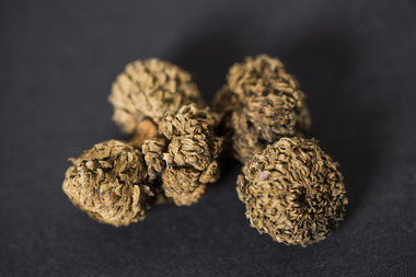 National Wool Museum
Acorn
Acorn and caps are from a 15 metre high Valonia oak tree (Quercus ithaburensis macrolepis) which was uprooted during a storm on Tuesday, 1st December 1987. The tree was planted in the Geelong Botanic Gardens by the first curator, Daniel Bunce, from an acorn shipped to Charles Ibbotson from Southern Europe in 1861. Ibbotson was the Chairman of the Management Committee of the Gardens and a woolbroker and merchant who founded the company Dalgety, Ibbotson and Co. with F.G. Dalgety in 1852. The acorns arrived in poor condition, but later established well. Very few Valonia Oaks were successfully propagated in Australia. Valonia oak caps were an important species which were used in the European tanning industry and Australian tanners were eager to grow the oak here.Five immature acorn caps from a Valonia oak, first planted in the Geelong Botanic Gardens in 1861 from acorns forwarded by Charles Ibbotson. Acorn and cap from a Valonia oak, first planted in the Geelong Botanic Gardens in 1861 from acorns provided by Charles Ibbotson. geelong botanic gardens dennys, lascelles limited city of greater geelong, tanning, valonia oak, ibbotson, mr a. charles, the heights, newtown, geelong. -
 Wodonga & District Historical Society Inc
Album - Ringer's River by Des Martin - Settings
Image 1: "de KERILLEAU" - Alongside Wodonga, home of the Watson family, was built by Charles Huon de Kerilleau, founder of the Wodonga Run. Huon took up his country in 1836, living then about 13 miles from the present homestead, the front portion of which was built about 1870. The actual age of an earlier portion is not known. Excellent for "Barmagulla". Image 2: "THE HERMITAGE" - Home of the Taylor family, is 13 miles from Wodonga. It was begun in 1852 and finished in 1854, and is the oldest occupied home in the area. The original atmosphere of the interior is maintained. As "Gooloora" its little balcony would provide a splendid vantage point for MacLough's speech. Image 3: Murray River Country above Granya, Victoria Image 4: Looking over Murmungee from the Buckland Gap near Beechworth, VictoriaThe album and images are significant because they document literature written by a prominent member of the Wodonga community. The presentation of this precis was supported by several significant district families and individuals.Coloured photos of venues suggested as settings for filming of the series. des martin, many a mile, ringer's river, northeast victoria stories -
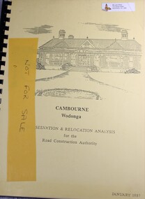 Wodonga & District Historical Society Inc
Booklet - Cambourne Wodonga : Conservation & Relocation Analysis for the Road Construction Authority, John & Thurley O'Conner, 1987
Research paper into the viability of relocating Cambourne Homestead in 2006 in order to make way for the widening and upgrade of the Hume Highway.non-fictionResearch paper into the viability of relocating Cambourne Homestead in 2006 in order to make way for the widening and upgrade of the Hume Highway. cambourne homestead wodonga, heritage building wodonga, carkeek family, potter family, building relocation -
 Stawell Historical Society Inc
Photograph, Four Posts Inn in Glenorchy -- Building no longer exists
Four Posts Inn. Glenorchy built about 1841 by John Gleeson on the Wimmera River at Glenorchy. Building no longer exists as burnt down in 1944. Located on the site now known as Glenorchy (Victoria). Glenorchy is approximately 20Km from the former Ashen's pastoral run occupied by Dugald McPherson. The Four post Inn was a "Staging Camp" for the police escort route during the transportation of gold by road from Mount Alexander gold fields (Bendigo) to Adelaide South Australia in 1852-53. The police escort is known to have called in at Ashens homestead to visit Dugald McPherson. The Four Post Inn was the scene on the occasion of and encounter between the police escort and bushrangers. At a later date The Four Post Inn was a staging camp for the horse drawn coach service between Stawell and Horsham.Small weatherboard building with no verandah and tree blocking the view. Cat in front of doorway.stawell -
 Bendigo Historical Society Inc.
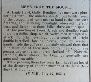
Slide - DIGGERS & MINING. THE DIGGING - THE DIGGERS, c1850s
Diggers & Mining. The Digging - The Diggers. Slide; An article titled 'Mems From The Mount' At Eagle Hawk Gully, Bendigo, five men were plundering a tent - the inmates shouted out lustily; some of the occupants of tent near at hand rushed out with firearms, and it being moonlight, observed the robbers, and, firing into them, killed three on the spot. At the junction of Forest Creek and Bendigo roads there is a coffee shop, which twelve men attempted to attack the other evening; but a couple of bright double-barrelled fowling pieces, held by the resolute hands inside the coffee shop plainly showed them that possession; so the scoundrels skulled of. Not with-standing these stories, the Diggers generally are quiet and peaceable. While penning these few remarks, I have just heard of the discovery of another murder at the New Bendigo Flat Diggings. (M.M.H., July 17, 1852) Markings: -- 994.LIF:6. Used as a teaching aid.hanimounteducation, tertiary, goldfields -
 Bayside Gallery - Bayside City Council Art & Heritage Collection
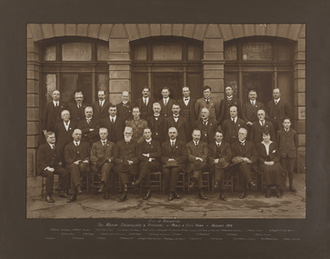
Photograph - sepia photograph, City of Brighton Mayor, Councillors and Officers - Peace & City Year - August 1919, 1919
brighton, council, mayor, councillors, officers, brighton town hall, t. vincent, park ranger, j.n. clark, overseer, f. blackham, press, r.j. lawrence, bank manager, a. vogt, assistant, j. clementson, inspector, l.w.p baker, assistant town clerk, g.w. woodward, hallkeeper, g. marsh, curator, a.f. magill c.e., city engineer, w. turner, cr. w.e. briggs, dr w.c. mcclelland, health officer, cr c.h.j. pickett, c.h. livesey, rate collector, cr j.a. grant, cr. j.w. satchwell, cr p.a. oakley, j. ritson, librarian, cr c.a. hack, cr j. richards, cr h.e. hall, cr t. wilson, j.h. taylor, town clerk, cr. w.p. francis, cr j.b. grout j.p., cr h.e. pullman, g.h. jefferson, solicitor, miss d.m. grout, typist, d. thomas, office boy, peace and city year -
 The Beechworth Burke Museum
Photograph - Photograph - Reproduction, ca. 1900
This image shows the approach to Beechworth from the south-west via the Newtown Bridge. Numerous early buildings line the road as it bifurcates to become Ford and High Streets on the ridge above Spring Creek and Newtown Falls. The sloping, rocky terrain and water course along the gorge show evidence of the intense mining activity that occurred at the site. The Ovens Gold Rush at Beechworth started when gold was found at Spring Creek in February 1852, prompting an influx of miners from around the world. The population grew over 20,000 by 1857. While the earliest mining at Beechworth was similar to that in other Victorian goldfields like Ballarat and Bendigo, Beechworth is notable for its use of hydraulic sluicing as a major method of removing wash-dirt. Hydraulic sluicing employs high pressure jets of water to blast away large areas of earth and wash it down to be run through a sluice box. Gold gets caught in the sluice and the remaining slurry is washed away. This method of mining is extremely effective but causes significant environmental impacts and damage to waterways. Large water quantities were required for large-scale sluicing, and the long water races and deep tailraces that were constructed in the Beechworth area in the nineteenth century are nonetheless considered feats of engineering. The site in the photograph is associated with the Rocky Mountain Mining Company who constructed an eight hundred meter tunnel under the township between 1876-1880 to reduce water levels at Spring Creek, which had been subject to diversions since the earliest days of alluvial mining. Over four million ounces of gold (115 tones) were found at Beechworth between 1852 and 1868, and the wealth from the gold rushes built Beechworth and the nationally significant buildings that remain standing today.This image shows the early development of the Beechworth township above Spring Creek, where gold was discovered in 1852. Evidence of hydraulic sluicing, a uniquely predominant method at Beechworth, and water-works engineering are present in the landscape. By the 1870s, alluvial gold deposits were depleted and increasingly complex engineering was required so deeper shafts could reach bedrock. This image is significant for understanding changes to the landscape and the evolution of mining methods and engineering practices related to the extensive construction, manipulation and management of water networks. The shift from smaller scale alluvial mining to larger company dominance in the mining industry has implications for understanding wider social, economic, political and industrial changes in the region of Beechworth and within the context of the Victorian Gold Rush more broadly. A black and white rectangular reproduction photograph printed on photographic paper. burke museum, beechworth museum, beechworth, gold fields, gold rush, victorian gold rush, hydraulic sluicing, rocky mountain mining company, spring creek, netwown falls, mining tunnels, water races, tailraces, colonial australia, australian gold rushes, mining technology, beechworth historic district, indigo gold trail, migration, indigo shire, gold mining, gold mining history -
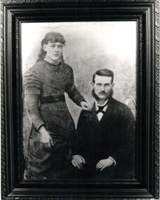 Hume City Civic Collection
Photograph
A portrait of a couple with the female standing and the male seated identified as Elizabeth and John Wilson. A b/w photo.Handwritten on back: PHOTO OF ELIZABETH AND JOHN ANDREW WILSON / b 1862 Sunbury bn 2 May 1861 Ballan, Vic / married 10th April 1882 SUNBURY / d 19 OCT 1937 Coburg d 17 AUG 1898 MELB HOSP. BURIED MELBOURNE GEN. CEMETERY / (Elizabeth) BURIED FAWKER CEMETERY / THEIR CHILDREN WILLIAM JOHN ANDREW WILSON B 1883 ELIZABETH FLORENCE SELINA WILSON B 1885 SUNBURY MAUD EDITH WILSON B 1887 SARAH MABEL LOUISE WILSON B 1890 ELIZABETH'S PARENTS WERE: WILLIAM JOSEPH DONELLY AND ELIZABETH nee CLARK married 1852 BRAMPTON, ENGLANDwilson, elizabeth (mrs), john andrew, weddings, sunbury, william john, elizabeth florence selina, maud edith, sarah mabel louise, donelly, william joseph, clark, elizabeth (miss), andrew, mcdaid, sarah (miss), sarah (mrs), george evans collection