Showing 733 items matching "aerial photo"
-
 Port Melbourne Historical & Preservation Society
Photograph - Aerial view of Yarra River and surrounds, 1990s
COPYRIGHT THE AGE Aerial photograph showing the Yarra River, Webb Dock, Port Melbourne beach, Princes pier, West Gate Bridge, Maribyrnong River, Swanston Dock and Melbourne City skyline. Taken mid 1990sStamped "Copyright. This photograph may not be reproduced without permission in writing from the Photo sales department of "the Age"'built environment - commercial, engineering - bridges, fishermans bend, natural environment - beaches and foreshore, piers and wharves - princes pier, piers and wharves - webb dock, transport - shipping, yarra river, west gate bridge, sandridge beach, maribyrnong river, swanston dock -
Port Melbourne Historical & Preservation Society
Photograph - Photograph board, Seven aerial views of J Kitchen & Sons site, Port Melbourne, J Kitchen & Sons Pty Ltd. Port Melbourne 1951, 1951
Large brown cardboard with seven (7) B&W aerial photographs pasted on it. Taken in 1951. Photo 1 - South East direction with Boundary Street in foreground, Kitchens buildings and Football Ground (cricket being played) Photo 2 - South West direction towards the Bay showing Station and Princes Piers, with ships in the distance. Photo 3 - almost directly above Kitchens Photo 4 - directly above kitchens Photo 5 - looking West including the Yarra River Photo 6 - looking North with Kitchen's storage and football ground in foreground Photo 7 - looking north east with football ground in foregrpound left and Yarra River top right.industry - manufacturing, built environment - industrial, piers and wharves - princes pier, piers and wharves - station pier, sport - australian rules football, sport - cricket, sport - recreational grounds, j kitchen & sons pty ltd, port melbourne football and cricket ground, north port oval -
Port Melbourne Historical & Preservation Society
Photograph - Aerial view of J Kitchen & Sons site, Port Melbourne, C D Pratt Airview, 21 Mar 1939
COPYRIGHT C D PRATT Black and white photograph of J Kitchen & Sons Pty Ltd. On back "Aerial view looking North East, 21st March 1939". Signs on three middle buildings 'J Kitchen & Sons Pty Ltd'; 'Pure Velvet Soap'; 'Electrine Candles'. Sign 'Australian Box Mills' on building to left "E L Pinkus' on building to Nort east and behind it 'Petersen & La...'"This photo is copyright" and information on owner - C D Pratt 86 McCracken St, Essendonindustry - manufacturing, j kitchen & sons pty ltd, australian box mills, e l pinkus, petersen -
Port Melbourne Historical & Preservation Society
Photograph - Aerial view of cruise ships at Port Melbourne piers, 13 Feb 2001
This photograph records the concurrent visit to Station Pier of three cruise ships - the peak of the Cruising Victoria strategy aimed at encouraging cruise shipping to Melbourne. Also the Devil Cat was berthed at Station Pier on this day but not in the photo (4 ships in one day)Aerial colour photograph taken by The Age, showing from left to right, cruise ships Regal Princess, QE2 and Silver Cloud, all at Station Pier on 13 February 2001. An unusual persective showing the rear of 'The Anchorage', formerly Swallow and Ariell, also Stokes and Princes Streetspiers and wharves - station pier, transport - shipping, rms queen elizabeth 2, qe2, swallow & ariell ltd, regal princess, silver cloud -
 Port Melbourne Historical & Preservation Society
Photograph - Pental/Symex Museum, Woodruff Street, Port Melbourne, Oct 2011
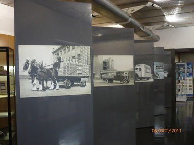
... (.05) framed aerial view of the site plus other photos... aerial view of the site plus other photos and ledgers (.06) full ...The pictures were taken in October 2011 by PMHPS members and in February 2013 the contents of the museum were given to PMHPS for safekeeping prior to the closure of the site.Pictures taken inside the Pental/Symex museum in Woodruff St building. Displaying historical items and photos of interest in relation to the activities of J Kitchen & Sons on this site. (.01) some of the display boards within the museum (.02) a framed aerial photographic view of the site (.03) Ledgers, photographs, trophies (.04) bench with books, photos, candlesticks (.05) framed aerial view of the site plus other photos and ledgers (.06) full wall and bench of display (.07) Horse drwan cart of Velvet soap - one of the display boards mentioned in .01 (.08) Open truck loaded with Velvet soap - one of the display boards mentioned in .01 (.09) Framed photo of Candle Room - one of the display boards mentioned in .01 (.10) Velvet Soap truck, enclsed van - one of the display boards mentioned in .01built environment - industrial, business and traders - soaps/candles, j kitchen & sons pty ltd, pental products pty ltd, symex holdings ltd -
 Monbulk RSL Sub Branch
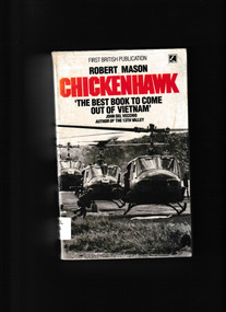
Book, Corgi books, Chickenhawk, 1984
Nearly a million copies of Chickenhawk have been sold since it was first published in 1983. Now with a new afterword and photos from the author, this straight-from-the-shoulder account tells the truth about the helicopter war in Vietnam, and a personal story of men under fire. Robert Mason, a veteran of more than one thousand combat missions, gives descriptions that cut to the heart of the combat experience: the fear and belligerence, the quiet insights and raging madness, the lasting friendships and sudden death -- the extreme emotions of a "chickenhawk" in constant danger.p.399.non-fictionNearly a million copies of Chickenhawk have been sold since it was first published in 1983. Now with a new afterword and photos from the author, this straight-from-the-shoulder account tells the truth about the helicopter war in Vietnam, and a personal story of men under fire. Robert Mason, a veteran of more than one thousand combat missions, gives descriptions that cut to the heart of the combat experience: the fear and belligerence, the quiet insights and raging madness, the lasting friendships and sudden death -- the extreme emotions of a "chickenhawk" in constant danger.vietnam war - aerial operations, vietnam war - helicopter pilots - biography -
 Bendigo Historical Society Inc.
Photograph - HANRO COLLECTION: AERIAL VIEW OF HANRO BENDIGO
... and White aerial view photograph of the Hanro Knitting Mills ...Photograph. Black and White aerial view photograph of the Hanro Knitting Mills, Hargreaves Street, Bendigo, in the centre of the photo.organization, business, hanro knitting mills, hanro -
 Bendigo Historical Society Inc.
Document - BASIL WATSON COLLECTION: ADVERTISING POSTERS FOR AVIATION DISPLAYS OF B WATSON, 1916- 1917
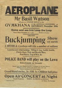
Collection of advertising posters for aviation displays of Basil Watson: a. ''Aeroplane'' - gymkhana at Aspendale Racecourse, 30th Dec, (1916); b. ''Sensational Aviation'' - general leaflet on Basil Watson with picture of plane; c. ''Aerial Mail'' Mt Gambier to Melbourne includes photo of biplane and Basil Watson; d. ''Sensational Aviation'' Basil Watson is coming.person, individual, basil watson -
Moorabbin Air Museum
Document (item) - Bryan Ridgeway Collection See Description for list of items
-
 B-24 Liberator Memorial Restoration Australia Inc
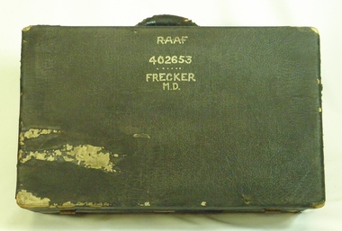
Suitcase from Mason Day Frecker, 1930s
Suitcase issued to aircraft captains or crew by RAAF during World War II. The contents of M D Frecker's suitcase include World War II medals awarded to the owner, photographs, maps, pilots' handbooks, language dictionaries (Malay, Pidgin, Japanese), propaganda leaflets dropped by Japanese.Has historical and social significance, also research significance. Provenance known, owner piloted B-24 Liberator bombers and General Blamey's personal aircraft; item was donated by son. Great interpretive potential.Worn dark suitcase belonging to Mason Day Frekker, strong cardboard covered with 'leatherette', metal fasteners on front, with carry handle. Suitcase contains Flying Log Book RAAF, Wedding Photo, National Archives Record Search Mason Day Frecker, Distinguished Flying Medal Register WW2 x 3, Papers on Medals and Victorian Ground Crew Numbers, Files 1 - 2 - 3 - Photographs, Leaflets, Pilots' Notes, Maps - Germany (28 maps), Buttons and badges and other medals."RAAF/402653/Frecker/M.D." on top surface, "M.D.F." on front surface under handle.b24 liberator bomber, world war ii, raaf pilot, world war ii aerial photographs, a22.00 -
 National Vietnam Veterans Museum (NVVM)
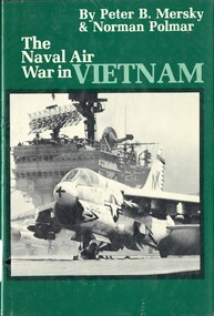
Book, Mersky, Peter B. and Polmar, Norman, The Naval Air War in Vietnam, 1981
Over 200 photos, plus maps and drawings.Over 200 photos, plus maps and drawings. 1961-1975 - aerial operations - american, vietnam war, 1961-1975 - naval operations, american, the gulf of tonkin -
 St Kilda Historical Society
Photograph - Photo map, 28/01/1951
... Black and white aerial photograph Photograph Photo map ...One of a series of photo-maps produced for the Department of Crown Lands and Survey (1857-1983). For correlation with a current map, and access to other historical photo maps of Victoria, see the Historic Photo-Maps Index published by the Department of Environment, Land, Water and Planning at https://services.land.vic.gov.au/DELWPmaps/historical-photomaps/Black and white aerial photograph1424-45 SECRET 534 Run 18 Lens 12" Melbourne Metropolitan 12150 28.1.51 M639albert park, st kilda junction, st kilda pier, catani gardens, st kilda, prahran, albert park lake, 1951, middle park, st kilda beach, windsor -
 St Kilda Historical Society
Photograph - Photo map, 17/01/1951
... Carlisle Street St Kilda melbourne One of a series of photo-maps ...One of a series of photo-maps produced for the Department of Crown Lands and Survey (1857-1983). For correlation with a current map, and access to other historical photo maps of Victoria, see the Historic Photo-Maps Index published by the Department of Environment, Land, Water and Planning at https://services.land.vic.gov.au/DELWPmaps/historical-photomaps/Black and white aerial photograph1414-21 538 Run 19 Lens 12" Melbourne Metropolitan 12150 17.1.51 M586st kilda, st kilda botanical gardens, peanut farm, elwood, 1951, point ormond, elwood canal, st kilda beach -
 St Kilda Historical Society
Photograph - Photo map, 28/01/1951
... and white aerial photograph Photograph Photo map ...One of a series of photo-maps produced for the Department of Crown Lands and Survey (1857-1983). For correlation with a current map, and access to other historical photo maps of Victoria, see the Historic Photo-Maps Index published by the Department of Environment, Land, Water and Planning at https://services.land.vic.gov.au/DELWPmaps/historical-photomaps/Black and white aerial photograph1424-118 534 Run 20 Lens 12" Melbourne Metropolitan 12150 18.1.51M639elwood, point ormond, elwood park, elsternwick park, elwood beach, 1951 -
 St Kilda Historical Society
Photograph - Photo map, 17/01/1951
... Carlisle Street St Kilda melbourne One of a series of photo-maps ...One of a series of photo-maps produced for the Department of Crown Lands and Survey (1857-1983). For correlation with a current map, and access to other historical photo maps of Victoria, see the Historic Photo-Maps Index published by the Department of Environment, Land, Water and Planning at https://services.land.vic.gov.au/DELWPmaps/historical-photomaps/Black and white aerial photograph1414-20 538 Run 19 Lens 12" Melbourne Metropolitan 12150 17.1.51 M586elwood, elsternwick, st kilda east, balaclava, ripponlea, 1951 -
 St Kilda Historical Society
Photograph - Photo map, 28/01/1951
... Carlisle Street St Kilda melbourne One of a series of photo-maps ...One of a series of photo-maps produced for the Department of Crown Lands and Survey (1857-1983). For correlation with a current map, and access to other historical photo maps of Victoria, see the Historic Photo-Maps Index published by the Department of Environment, Land, Water and Planning at https://services.land.vic.gov.au/DELWPmaps/historical-photomaps/Black and white aerial photograph1424-44 534 Run 18 Lens 12" Melbourne Metropolitan 12150 28.1.51 M639 -
 St Kilda Historical Society
Photograph - Photo map, 28/01/1951
... aerial photograph Photograph Photo map ...One of a series of photo-maps produced for the Department of Crown Lands and Survey (1857-1983). For correlation with a current map, and access to other historical photo maps of Victoria, see the Historic Photo-Maps Index published by the Department of Environment, Land, Water and Planning at https://services.land.vic.gov.au/DELWPmaps/historical-photomaps/Black and white aerial photograph1424-43 534 Run 18 Lens 12" Melbourne Metropolitan 12150 28.1.51 M639armadale, malvern, st kilda cemetery, caulfield north, st kilda east, 1951 -
 St Kilda Historical Society
Photograph - Photo map, 30/01/1960
... aerial photograph Photograph Photo map ...One of a series of photo-maps produced for the Department of Crown Lands and Survey (1857-1983). For correlation with a current map, and access to other historical photo maps of Victoria, see the Historic Photo-Maps Index published by the Department of Environment, Land, Water and Planning at https://services.land.vic.gov.au/DELWPmaps/historical-photomaps/Black and white aerial photographVic 1093-62 Melbourne & Metropolitan Project Run 21 30.1.60 Lens 10" 8.200middle park, albert park, catani gardens, st kilda west, 1960 -
 St Kilda Historical Society
Photograph - Photo map, 30/01/1960
... aerial photograph Photograph Photo map ...One of a series of photo-maps produced for the Department of Crown Lands and Survey (1857-1983). For correlation with a current map, and access to other historical photo maps of Victoria, see the Historic Photo-Maps Index published by the Department of Environment, Land, Water and Planning at https://services.land.vic.gov.au/DELWPmaps/historical-photomaps/Black and white aerial photographVic 1093-60 Melbourne & Metropolitan Project Run 21 30.1.60 Lens 10" 8.200st kilda, albert park, prahran, windsor, south yarra, 1960 -
 St Kilda Historical Society
Photograph - Photo map, 30/01/1960
... aerial photograph Photograph Photo map ...One of a series of photo-maps produced for the Department of Crown Lands and Survey (1857-1983). For correlation with a current map, and access to other historical photo maps of Victoria, see the Historic Photo-Maps Index published by the Department of Environment, Land, Water and Planning at https://services.land.vic.gov.au/DELWPmaps/historical-photomaps/Black and white aerial photographVic 1092-36 Melbourne & Metropolitan Project Run 22 30.1.60 Lens 10" 8.200st kilda, st kilda pier, st kilda beach, catani gardens, 1960 -
 St Kilda Historical Society
Photograph - Photo map, 30/01/1960
... Carlisle Street St Kilda melbourne One of a series of photo-maps ...One of a series of photo-maps produced for the Department of Crown Lands and Survey (1857-1983). For correlation with a current map, and access to other historical photo maps of Victoria, see the Historic Photo-Maps Index published by the Department of Environment, Land, Water and Planning at https://services.land.vic.gov.au/DELWPmaps/historical-photomaps/Black and white aerial photographVic 1092-38 Melbourne & Metropolitan Project Run 22 30.1.60 Lens 10" 8.200st kilda, st kilda beach, st kilda pier, catani gardens, 1960, st kilda botanical gardens, peanut farm -
 St Kilda Historical Society
Photograph - Photo map, 30/01/1960
... aerial photograph Photograph Photo map ...One of a series of photo-maps produced for the Department of Crown Lands and Survey (1857-1983). For correlation with a current map, and access to other historical photo maps of Victoria, see the Historic Photo-Maps Index published by the Department of Environment, Land, Water and Planning at https://services.land.vic.gov.au/DELWPmaps/historical-photomaps/Black and white aerial photographVic 1092-40 Melbourne & Metropolitan Project Run 22 30.1.60 Lens 10" 8.200st kilda east, balaclava, ripponlea, st kilda cemetery, 1960 -
 St Kilda Historical Society
Photograph - Photo map, 30/01/1960
... Carlisle Street St Kilda melbourne One of a series of photo-maps ...One of a series of photo-maps produced for the Department of Crown Lands and Survey (1857-1983). For correlation with a current map, and access to other historical photo maps of Victoria, see the Historic Photo-Maps Index published by the Department of Environment, Land, Water and Planning at https://services.land.vic.gov.au/DELWPmaps/historical-photomaps/Black and white aerial photographVic 1092-42 Melbourne & Metropolitan Project Run 22 30.1.60 Lens 10" 8.200malvern, caulfield, caulfield park, 1960 -
 St Kilda Historical Society
Photograph - Photo map, 30/01/1960
... Carlisle Street St Kilda melbourne One of a series of photo-maps ...One of a series of photo-maps produced for the Department of Crown Lands and Survey (1857-1983). For correlation with a current map, and access to other historical photo maps of Victoria, see the Historic Photo-Maps Index published by the Department of Environment, Land, Water and Planning at https://services.land.vic.gov.au/DELWPmaps/historical-photomaps/Black and white aerial photographVic 1091-112 Melbourne & Metropolitan Project Run 23East 30.1.1960 Lens 10" 8.200elwood, point ormond, elwood park, elwood canal, 1960 -
 St Kilda Historical Society
Photograph - Photo map, 30/01/1960
... Carlisle Street St Kilda melbourne One of a series of photo-maps ...One of a series of photo-maps produced for the Department of Crown Lands and Survey (1857-1983). For correlation with a current map, and access to other historical photo maps of Victoria, see the Historic Photo-Maps Index published by the Department of Environment, Land, Water and Planning at https://services.land.vic.gov.au/DELWPmaps/historical-photomaps/Black and white aerial photographVic 1091-110 Melbourne & Metropolitan Project Run 23East 30.1.60 Lens 10" 8.200elwood, elsternwick, elsternwick park, ripponlea, st kilda east, caulfield, balaclava, 1960 -
 St Kilda Historical Society
Photograph - Photo map, 30/01/1960
... Carlisle Street St Kilda melbourne One of a series of photo-maps ...One of a series of photo-maps produced for the Department of Crown Lands and Survey (1857-1983). For correlation with a current map, and access to other historical photo maps of Victoria, see the Historic Photo-Maps Index published by the Department of Environment, Land, Water and Planning at https://services.land.vic.gov.au/DELWPmaps/historical-photomaps/Black and white aerial photographVic 1091-1 Melbourne & Metropolitan Project Run 24East 30.1.60 Lens 10" 8.200elwood, elwood beach, elwood park, 1960 -
 St Kilda Historical Society
Photograph - Photo map, 30/01/1960
... Carlisle Street St Kilda melbourne One of a series of photo-maps ...One of a series of photo-maps produced for the Department of Crown Lands and Survey (1857-1983). For correlation with a current map, and access to other historical photo maps of Victoria, see the Historic Photo-Maps Index published by the Department of Environment, Land, Water and Planning at https://services.land.vic.gov.au/DELWPmaps/historical-photomaps/Black and white aerial photographVic 1091-2 Melbourne & Metropolitan Project Run 24East 30.1.60 Lens 10" 8.200elwood, elwood park, elwood beach, elsternwick park, 1960 -
 St Kilda Historical Society
Photograph - Photo map, 3/3/1964
... Carlisle Street St Kilda melbourne One of a series of photo-maps ...One of a series of photo-maps produced for the Department of Crown Lands and Survey (1857-1983). For correlation with a current map, and access to other historical photo maps of Victoria, see the Historic Photo-Maps Index published by the Department of Environment, Land, Water and Planning at https://services.land.vic.gov.au/DELWPmaps/historical-photomaps/Black and white aerial photographVic 1833 Melbourne 1963 Project Run 15 3.3.64 Lens 205 152.70 M/M 5.150 56prahran, fawkner park, south yarra, albert park, 1964 -
 St Kilda Historical Society
Photograph - Photo map, 14/12/1963
... and white aerial photograph Photograph Photo map ...One of a series of photo-maps produced for the Department of Crown Lands and Survey (1857-1983). For correlation with a current map, and access to other historical photo maps of Victoria, see the Historic Photo-Maps Index published by the Department of Environment, Land, Water and Planning at https://services.land.vic.gov.au/DELWPmaps/historical-photomaps/Black and white aerial photographVic 1807 Melbourne 1963 Project Run 16 14.12.63 Lens 205 152.70 M/M 5.150 179st kilda, prahran, albert park, st kilda east, balaclava, 1963 -
 St Kilda Historical Society
Photograph - Photo map, 14/12/1963
... Black and white aerial photograph Photograph Photo map ...One of a series of photo-maps produced for the Department of Crown Lands and Survey (1857-1983). For correlation with a current map, and access to other historical photo maps of Victoria, see the Historic Photo-Maps Index published by the Department of Environment, Land, Water and Planning at https://services.land.vic.gov.au/DELWPmaps/historical-photomaps/Black and white aerial photographVic 1807 Melbourne 1963 Project Run 16 14.12.63 Lens 205 152.70 M/M 5.150 181st kilda cemetery, caulfield north, st kilda east, armadale, malvern, 1963