Showing 653 items
matching bank document
-
 Buninyong & District Historical Society
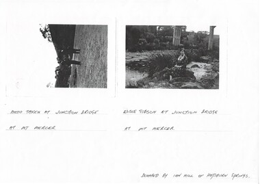
Photograph - Photocopy of two original B/W photographs, Mt Mercer Junction Bridge, photocopy made in 1995
Photos taken of the Junction Bridge at Mt Mercer, documenting the location, date unknown.The photos document the physical status of the location of the Junction Bridge at Mt Mercer at the time of photography, date unknown.Mt Mercer Junction Bridge. Photo 1 shows two men on the river bed probably looking at the bridge. Photo 2 shows Elsie Gibson sitting on the river bank with the bridge in the background.Photo 1. Photo taken at Junction Bridge at Mt Mercer. Photo 2. Elsie Gibson at Junction Bridge at Mt Mercer. Donated by Ian Hill of Hepburn Springsjunction bridge, mt mercer, bridge, elsie gibson, gibson, landscape -
 Kew Historical Society Inc
Photograph - 2 Young Street, Kew, Paramount Photos, 1920s
Subdivision plans are historically important documents used as evidence of the growth of suburbs in Australia. They frequently provide information about when the land was sold on which a built structure was subsequently constructed as well as evidence relating to surveyors and real estate and financial agents. The numerous subdivision plans in the Kew Historical Society's collection represent working documents, ranging from the initial sketches made in planning a subdivision to printed plans on which auctioneers or agents listed the prices for which individual lots were sold. In a number of cases, the reverse of a subdivision plan in the collection includes a photograph of a house that was also for sale by the agent. These photographs provide significant heritage information relating house design and decoration, fencing and household gardens.A prepossessing, large home constructed in the Arts and Crafts style. Located on the banks of the Yarra at 2 Young Street, Kew overlooking the factories of Richmond, the design of the house takes account of the gradient with the addition of a level below the front entrance. The elegant roof includes a number of projecting gables and dormers. The gables are typically half-timbered and rendered. In addition to the asymmetrically placed portico, there are at least two open verandas, supported by timber pillars and with roofs that reflect the overall pitch of the roof of the housereal estate photographs, 2 young street - kew -
 Surrey Hills Historical Society Collection
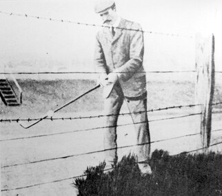
Photograph, Harry Culliton at Surrey Hills Golf Club
Reproduced by permission of Mr John Arnold from his book: "The Riversdale Golf Club - a history, 1892-1977." Copyright to book: Riversdale Golf Club. Surrey Hills Golf Club operated from 1892-1908 then moved and became Riversdale Golf Club. The game was played across paddocks from Trafalgar Street, Mont Albert to Whitehorse Road and down Victoria Crescent to where Box Hill TAFE is now located in Elgar Road. There were problems with cows eating the tee flags! The clubhouse still exists as 30 Trafalgar Street. The Surrey Hills Golf Club was founded by Mr Hugh W McLeod in 1894. The first president was Mr A W Harston. Mr William Meader was the first honorary secretary and the club champion for several years. Another notable identity was Mr. Harry Culliton, who contributed golf notes to "The Argus" for many years. Harry Culliton (clerk; later bank manager) married Christina Mary Rothwell of Surrey Hills in 1897. They initially live in Canterbury Road before moving to 'Bayview' in Harding Street. They had 3 sons. The eldest Kenneth Rothwell Culliton married Molly Fanny Arthur in 1940. They continued to live in 'Bayview'. Molly was a foundation member of the Surrey Hills Historical Society.The image is significant in documenting the Surrey Hills Golf Club, no longer in existence, but also members of early Surrey Hills families. Black and white photo showing a barbed wire and post fence behind which stands a man, identified as Harry Culliton. He is wearing a suit, cap and a tie. He sports a large 'handle-bar' moustache and is gripping an iron golf club, preparing to strike a golf ball which is impaled on the barbed wire.Caption: "Harry Culliton playing from the barbed wire where his ball was impaled on the fence on the side of the coffin. To his opponent's dismay he managed to land the ball near the green and get down in two for a half."sports grounds, surrey hills golf club, riversdale golf club, clothing and dress, john arnold, harry culliton -
 Surrey Hills Historical Society Collection
Photograph, Grovedale Road Quarry in the 1920s - looking south, c1920
The quarry was part of John Butler Maling's property. He was one of the original settlers of the area and farmed the area between Weybridge Street and Whitehorse Road. Clay was quarried from part of this area and used to make the bricks used in the construction of his home, known as 'Ancyra'. This is still extant at the corner of Weybridge and James Streets. Maling grazed cows and used the quarry as a water source. He was the uncle of John Butler Maling, Mayor of Camberwell. He was married to Kate Conlon in 1882. They had 3 children: Silas Young, Alick and Zillah. Maling was born in c1829 in Shepreth, Cambridgeshire; he died in Surrey Hills on 9 October 1912 and is buried in Box Hill Cemetery - CE-*-0586. Mrs Kate Maling (born c1859 in Co Meath, Ireland) died at the property on 8 March 1921. She is buried in Brighton General Cemetery. Probate was valued at over 10,000 pounds and included other properties in Sandringham, Hawthorn and Macedon. At the time of her death the Surrey Hills property was described as being 23 acres with 2 brick houses, 1 cow, 2 heifers and 40 fowls or chickens. The property was subdivided after her death. The property was subdivided into 110 house blocks in c1923 - see Maling's Estate subdivision flyer on the State Library of Victoria's website. This shows that the Grovedale Park site had been acquired by Camberwell Council by this time. An attached newspaper clipping documents prices realised for a cross-section of blocks. The MMBW map of 1925, also on the SLV website, shows the outline of the clayhole / quarry. The quarry was filled in after several drownings or near drownings and the land is now occupied by a park and playground, known as Grovedale Road Park, maintained by the City of Boroondara. Beckett Park is sited on horizon to the left beyond the trees. This documents the landscape prior to close settlement and is material to early building and farming in the Surrey Hills area.Black and white photo of the quarry between Grovedale Road and James Street taken in the 1920s and looking south. In the foreground is an area of water with reeds in the LH corner. Beyond on the high banks there are single storey houses in the background and (?) some light poles. An object that looks like a tank on posts is in a cutting on the far bank.quarries, grovedale road, james street, clay quarries, farming, kate conlon, kate maling, john butler maling, ancyra -
 Surrey Hills Historical Society Collection
Photograph, Grovedale Road Quarry in the 1920s - looking north, c1920
The quarry was part of John Butler Maling's property. He was one of the original settlers of the area and farmed the area between Weybridge Street and Whitehorse Road. Clay was quarried from part of this area and used to make the bricks used in the construction of his home, known as 'Ancyra'. This is still extant at the corner of Weybridge and James Streets. Maling grazed cows and used the quarry as a water source. He was the uncle of John Butler Maling, Mayor of Camberwell. He was married to Kate Conlon in 1882. They had 3 children: Silas Young, Alick and Zillah. Maling was born in c1829 in Shepreth, Cambridgeshire; he died in Surrey Hills on 9 October 1912 and is buried in Box Hill Cemetery - CE-*-0586. Mrs Kate Maling (born c1859 in Co Meath, Ireland) died at the property on 8 March 1921. She is buried in Brighton General Cemetery. Probate was valued at over 10,000 pounds and included other properties in Sandringham, Hawthorn and Macedon. At the time of her death the Surrey Hills property was described as being 23 cres with 2 brick houses, 1 cow, 2 heifers and 40 fowls or chickens. The property was subdivided after her death. The quarry was filled in after several drownings or near drownings and the land is now occupied by a park and playground maintained by the City of Boroondara. Beckett Park is sited on horizon to the left beyond the trees. This documents the landscape prior to close settlement and is material to early building and farming in the Surrey Hills area.Black and white photo of the quarry between Grovedale Road and James Street taken in the 1920s and looking north. In the foreground is an area of water with high banks dividing the horizontal centre. Beyond are paddocks and trees behind which is a row of at least 3 single-storey houses. Light poles can be seen along a distant street. There are many mature trees in the background. The houses and trees are positioned along Whitehorse Road in the vicinity of Westminster Street. Shadows indicate the photo was taken in early morning or evening.quarries, grovedale road, james street, surrey hills, balwyn, clay quarries, ancyra, kate conlon, kate maling, john butler maling, farming -
 University of Melbourne, Burnley Campus Archives
Document - Student Work, Botanic Gardens Trust, Seed Bank Study of the Burnley Site, 12.05.2014
seed bank, burnley site, student work, assignment, seedlings, botanic gardens trust -
Canterbury History Group
Document - Once in a lifetime, 2001
Collection of copies of documents relating to the offer for sale of 121 Maling Road Canterbury by the State Savings Bank of Victoria in 2001.Includes Black and white photograph and plans for both floor of the building.canterbury, maling road, state savings bank of victoria, victorian railways, certificates, commonwealth bank, lanes -
Canterbury History Group
Document - Lease between Mayor, Councillors and Citizens of the City Of Camberwell and Trustees of the Canterbury Bowling Club, 1975
... Evan Banks as Trustees of Canterbury Bowling Club. Document ...Lease between City of Camberwell and Harry Cecil Worden, William James Adams and Arthur Evan Banks as Trustees of Canterbury Bowling Club.canterbury, canterbury bowling club, kendall street, city of camberwell, lawn bowls, worden> harry cecil, adams> william james, banks> arthur evan, legal documents, plans -
 Falls Creek Historical Society
Poster - Kangaroo Hoppet 2022
The Kangaroo Hoppet is Australia’s premier long distance cross country ski race, and a member of the Worldloppet series of international cross country ski events. The first race at Falls Creek was held in 1979 under the name of “Australian Birkebeiner”. It was a 21km race with about 80 participants organised by the Birkebeiner Nordic Ski Club of Mount Beauty. The course started and finished at Falls Creek Alpine Resort and took participants out into the Bogong High Plains. After running the event for 10 years, it was decided they should become part of the Worldloppet series of marathon ski races. Representatives from the Birkebeiner Nordic Ski Club and the Australian Ski Federation attended the Worldloppet Annual Meeting in Finland in June 1990 to put the case for the acceptance of an Australian event into the Worldloppet series. Before being admitted, they had to demonstrate that the Birkebeiner Club could run a world class event, so three months later in August 1990 a 42km event named the Australian International Ski Marathon was held at Falls Creek together with a 21km Birkebeiner race and a 7km event called the Birkebeiner Lite. The event was approved by delegates from USA, Norway and Austria, in 1991 Australia became the 12th member of Worldloppet, with the condition that there had to be a name change. After some late night discussion allegedly involving red wine from North East Victoria the main event became the 42km Kangaroo Hoppet, with the minor events being the 21km Australian Birkebeiner, and 7km Joey Hoppet. In the winter of 1991, the first Kangaroo Hoppet was held. It was a great success and has been a regular fixture on the international ski calendar ever since. It features the main 42km event as well as a 21km event and a 7km event. The Hoppet brings the Australian snowfields to an international audience. In 2022 the Men's Winner was Peter Wolter from USA in a time of 1:28:08.2. The winner of the Women's event was Jessie Diggins of USA in a time of 1:31:50.9This poster is significant because it documents an event which brings international attention to Falls Creek and the surrounding region.A poster featuring a cartoon image of hundreds of kangaroo skiers crossing through the blue finishing gate. The date 27 AUGUST 2022 is on a red sign above the gate. FALLS CREEK is also on the gate, as well as the names of some of the sponsors. Logos of AGL, the Birkebeiner Nordic Ski Club, Falls Creek, KANGAROO HOPPET/Worldloppet, FIS, Alpine Shire Council, and Community Bank Mount Beauty & District are across the bottom of the poster. , Below the image: 7, 21 & 42 Km Kangaroo Hoppetkangaroo hoppet, worldloppet events, falls creek, mt. beauty -
 Melbourne Legacy
Document, Presidents' Fund Origin - Howard and Georgina Berry Trust, 1985
A collection of documents about the Presidents Fund that was collated in 1985. First page is a summary by Legatee Isherwood dated 14/12/1966. Also included a document dated February 1985 written by Legatee Kemsley about the President's Fund that was established in 1933 with funds donated from the estate of Walter Berry in the name of his Company. The Howard and Georgina Berry Fund was to be used by the President to assist a legatee in financial difficulties. Legatee Kemsley was almost 90 and was passing on his knowledge of the history of the fund and its uses. He had served with Walter Berry in France when he was a personal assistant to General Monash. Also a poor quality copy of the original letter dated 24th February 1933 by Legatee Kemsley to the Trustees. There are two pages of a bank statement in 1984 showing the balance as being approximately $1,000. Was in a binder of documents that is passed from an outgoing President to the incoming President. It is primarily from the 1930s to 1990s. Most documents are being catalogued separately.A record of the inception and workings of the President's Fund.White A4 paper x 5 pages with black type about President's Fund in 1985 and two pages of bank statements.Signed in blue pen on fifth page, 'AN Kemsley, February 1985'.presidents fund, kem kemsley, walter berry -
 Wodonga & District Historical Society Inc
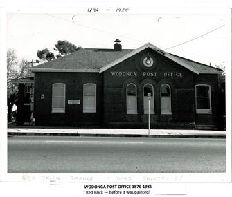
Photograph - Codling Collection 01 - Wodonga Post Office
Miss Olive Codling was a Foundation Member and a Life Member of the Wodonga Historical Society. Many of her photos are held in the Society Collection. The Wodonga Post Office was constructed on the corner of Sydney Road (High Street) and South Street in 1874. It was Wodonga’s second Post Office. The original post office opened on June 1, 1856 near Wodonga Creek. This building was originally built of red brick, although it was later painted over in white. It had an attached residence in South Street and was connected to it by a door. The residence was later demolished to move the mail boxes which had faced High Street, to South Street. The brick Telephone Exchange was constructed in 1946 behind the Post Office but separated from it. It operated as a manual exchange until the late 1960’s or early 1970’s. In 1985 a new post office was opened further south in High Street. This building, greatly renovated, is now part of the Wodonga Community College.This photo collection is significant as it documents how the businesses and buildings in Wodonga have evolved and contributed to community throughout the 20th century. A black and white image of the 2nd Wodonga Post Office. There are 6 windows across the front of the building and the name Wodonga Post Office below a round clock. To the left of the building is the royal insignia of the crown above the letters E.R. A sign for the Commonwealth Saving Bank of Australia is also attached to the wall.high st wodonga, wodonga post office, businesses wodonga -
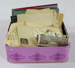 Wodonga & District Historical Society Inc
Financial record - Haeusler Collection: Tin of Letters, Foreign Money & Savings Bank Passbooks, Banque de Syrie et du Liban (Bank of Syria and Lebanon)
The Wodonga Historical Society Haeusler Collection provides invaluable insight into life in late nineteenth and early twentieth century north east Victoria. The collection comprises manuscripts, personal artefacts used by the Haeusler family on their farm in Wodonga, and a set of glass negatives which offer a unique visual snapshot of the domestic and social lives of the Haeusler family and local Wodonga community. The Haeusler family migrated from Prussia (Germany) to South Australia in the 1840s and 1850s, before purchasing 100 acres of Crown Land made available under the Victorian Lands Act 1862 (also known as ‘Duffy’s Land Act’) in 1866 in what is now Wodonga West. The Haeusler family were one of several German families to migrate from South Australia to Wodonga in the 1860s.This item has well documented provenance and a known owner. It forms part of a significant and representative historical collection which reflects the local history of Wodonga. It contributes to our understanding of the social history of early twentieth century Wodonga. Early 20th century rupee from British Ceylon (Sri Lanka), and interwar era livre from Greater Lebanon (Lebanon and Syria). The livre were issued during the French League of Nations mandate period. Collection of savings bank passbooks from the Savings Bank Wodonga. Text on letters, money and bank passbookshaeusler collection, wodonga, money, notes, bank notes, banking, currency, syria, lebanon, ceylon, sri lanka -
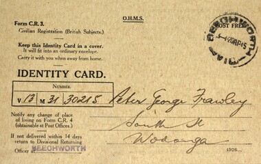 Wodonga & District Historical Society Inc
Document - Citizen Identity Cards World War II, Australian Federal Government, 1940s
These cards were issued during World War 11 to British subjects who were civilians. This included all non-indigenous adults born in Australia. The concept of Australian citizenship was only introduced by the Nationality and Citizenship Act of 1948. All adults had personal identity cards and were required to report changes of address to the government. These cards were particularly important in the identification and monitoring of Aliens (non-citizen residents) , particularly non-Europeans and Asian residents.Peter Frawley was a long-time resident of Wodonga. He was a veteran of Gallipoli and Fromelles. For his actions at Fromelles, he was awarded the French Croix de Guerre. After the war Peter became a successful jockey and one of his greatest successes was winning the Australian Steeple Chase at Caulfield in 1922. He was an active member of the Wodonga Turf Club and Bonegilla Race Club and a founding member of the Wodonga Show Society. Peter’s wife Connie was an integral member of the Wodonga Hospital fundraising committee, being awarded a life membership. Nereida Pearl Goyne (nee Emery) lived most of her life in Wodonga. She was actively engaged in the community until 2007 when she moved to Rutherglen where she passed away in January 2009.3 fawn coloured cards with black text, all stamped with the Beechworth Post Office stamp. They are identified as Form C.R.3 Civilian Registration (British Subjects).Written on both sides in ink: Detailed explanation of government regulations. On Card 1 in ink;" V13, M 31 ,30215" Signed "Peter George Frawley, South St Wodonga" Reversed signed by card holder and witness" On Card 2 in ink;" V13, M 02 ,2494" Signed Constance Frawley, South St Wodonga" Reversed signed C Frawley and witnessed P Frawley" Note - Ration book for 3 children" On Card 3 in ink;" V13, M 10 ,12251" Signed "Nereida Pearl Goyne, Bank St Wodonga" Reversed signed by card holder and witnessed by L.C. McCullough" Note Ration book for 2 children"identity cards, civilian registration, world war 2, ww11 -
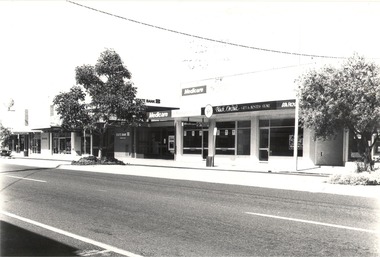 Wodonga & District Historical Society Inc
Photograph - Codling Collection 01 - Wodonga, High Street West - Gas company, State Bank, Medicare and Black Orchid, 1980s
Miss Olive Codling was a Foundation Member and a Life Member of the Wodonga Historical Society. Many of her prize-winning photos are held in the Society Collection. She also held a range of roles and committee positions in a wide range of Wodonga community organisations. These included the Horticultural Society, the Wodonga Arts Council, the Wodonga Camera Club and the Wodonga Lapidary Club. This photo collection is significant as it documents how the businesses and buildings in Wodonga have evolved and contributed to community throughout the 20th century.Wodonga, High Street West Businesses including Gas company, ESANDA, State Bank of Victoria, Toyworld, Medicare, Black Orchid Gift and Hostess Store, and the Royal Bank. The State Bank of Victoria was taken over by the Commonwealth Bank in 1990. The Medicare service was removed from Wodonga in 2015 and amalgamated with the Albury Service Centre. The Royal Bank (National Mutual Royal Bank) later merged with ANZ. wodonga businesses, high st wodonga, state bank, medicare wodonga, royal bank -
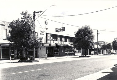 Wodonga & District Historical Society Inc
Photograph - Codling Collection 01 - Wodonga, High Street West - Terminus Hotel, Drummond Real Estate, Pet Shop, 1980s
Miss Olive Codling was a Foundation Member and a Life Member of the Wodonga Historical Society. Many of her prize-winning photos are held in the Society Collection. She also held a range of roles and committee positions in a wide range of Wodonga community organisations. These included the Horticultural Society, the Wodonga Arts Council, the Wodonga Camera Club and the Wodonga Lapidary Club. This photo collection is significant as it documents how the businesses and buildings in Wodonga have evolved and contributed to community throughout the 20th century.Wodonga, High Street West Businesses including Terminus Hotel, Tandy Electronics Drummond Real Estate, Pet Shop and old National / CBA Bank on corner. The Terminus Hotel was built in 1873. It was purchased by Annie and George Allen in 1879. In 1888 they added extensions including a billiard room, a dining room and 18 other rooms. After the death of her husband, Annie Allen continued to run the Terminus Hotel. She later married John Haldon and was licensee of the hotel until 1893 when the license was transferred to William Carkeek. Carkeeks owned the hotel from 1900 - 1903 and again from 1906 - 1909. It was destroyed by fire in 1998 and the building demolished in 1999. Cliff & Peter Drummond opened their first office in Wodonga in 1977.wodonga businesses, high st wodonga, terminus hotel, drummond real estate -
 Wodonga & District Historical Society Inc
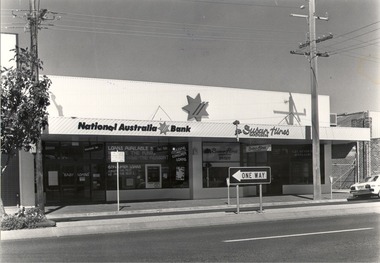
Photograph - Codling Collection 01 - High Street East - Susan Hines Hairdresser; National Bank; S & E Rendich Jewellers, 1980s
Miss Olive Codling was a Foundation Member and a Life Member of the Wodonga Historical Society. Many of her prize-winning photos are held in the Society Collection. She also held a range of roles and committee positions in a wide range of Wodonga community organisations. These included the Horticultural Society, the Wodonga Arts Council, the Wodonga Camera Club and the Wodonga Lapidary Club. This photo collection is significant as it documents how the businesses and buildings in Wodonga have evolved and contributed to community throughout the 20th century.Eastern side of High Street, Wodonga - Susan Hines Hairdresser; National Bank; S & E Rendich Jewellerswodonga businesses, high st wodonga, susan hines, s & e rendich -
 Wodonga & District Historical Society Inc
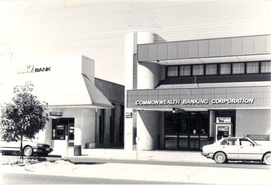
Photograph - Codling Collection 01 - High Street East - ANZ Bank, Commonwealth Banking Corporation, 1980s
Miss Olive Codling was a Foundation Member and a Life Member of the Wodonga Historical Society. Many of her prize-winning photos are held in the Society Collection. She also held a range of roles and committee positions in a wide range of Wodonga community organisations. These included the Horticultural Society, the Wodonga Arts Council, the Wodonga Camera Club and the Wodonga Lapidary Club. This photo collection is significant as it documents how the businesses and buildings in Wodonga have evolved and contributed to community throughout the 20th century.Eastern side of High Street, Wodonga - High Street East - ANZ Bank, Commonwealth Banking Corporation. Both of these banks have now moved to the opposite side of High Street as part of the redevelopment of the city centre. At the time of this entry in 2021 the Commonwealth Bank pictured is the office of Senator The Hon. Bridget McKenzie and the ANZ Bank building is vacant.wodonga businesses, high st wodonga, commonwealth bank wodonga, anz bank wodonga -
 Wodonga & District Historical Society Inc
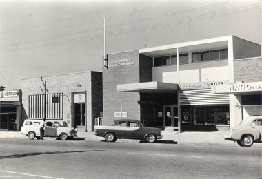
Photograph - Mann Collection Album - High Street East - ANZ Bank; Commonwealth Bank; Henshaw’s Shoes; National Bank, C. 1970s
Elaine Mann was married to David Mann, a successful Wodonga businessman and community leader who passed away in Wodonga in June 2012. David was a member of the Mann family who began their business in Wodonga in 1920. Elaine was a teacher in Wodonga for many years and an active member of the community.This photo collection is of significance as it documents how the businesses and buildings in Wodonga have evolved and contributed to community throughout the late 20th century.High Street East - ANZ Bank; Commonwealth Bank; Henshaw’s Shoes; National Bank. Mahoney's Newsagency on the left hand edge of the photo was located at 168 High Street and the National Bank was at 174 High Street. In 2021 this is the location of the R.A.C.V office. wodonga businesses, high st wodonga, henshaw's shoes, anz, commonwealth bank, national bank -
 Wodonga & District Historical Society Inc
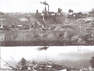
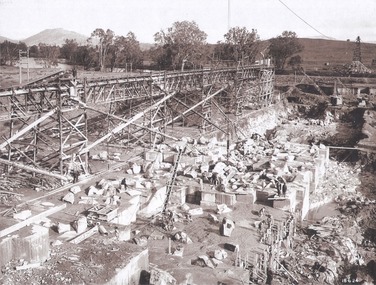
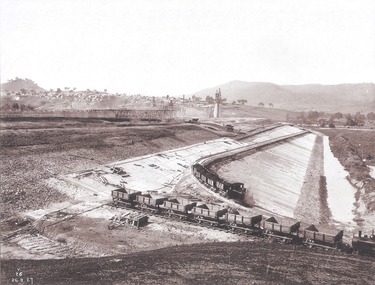
Album - Hume Reservoir Australia Album - View from the Victorian bank of the Murray River, May 1923
This set of photos is from a leather bound album bearing the inscription "HUME RESERVOIR AUSTRALIA" plus 'The Rt. Hon. L. C. M. S. Amery, P. C., M .P.' all inscribed in gold. It was presented to The Rt. Hon. L. C. M. S. Amery, P. C., M. P, Secretary of State for Dominion Affairs on the occasion of his visit to the Hume Reservoir on 2nd November 1927. This album is of local and national significance as it documents the planning and development of the Hume Reservoir up to 1927. It was the largest water reservoir in the British Empire. The album records the pioneering engineering work that went into its construction.DEPARTMENT OF PUBLIC WORKS, N.S.W. RIVER MURRAY WATERS SCHEME. HUME RESERVOIR. 12. View from the Victorian bank of the river showing in the foreground a levee bank along the New South Wales side of the river with connecting wings back to the higher ground, May 1923. The first stage in the construction of the Dam foundations was carried out inside the levee bank which was at a sufficient height to protect from floods the work going on inside. A length of 300 feet of the Dam was left at a low elevation to allow of the river flowing over it in the second stage of the operations and at the ends of the concrete was brought up above flood level. To divert the river, a Coffer Dam was built across the old bed above and below the Dam site and tying into the end of the concrete wall built inside the levee bank. This completely surrounded the remainder of the site of the Dam and south wing wall, including an area of 12½ acres.hume reservoir australia, river murray waters scheme, hume reservoir construction -
 Wodonga & District Historical Society Inc
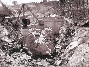
Album - Hume Reservoir Australia Album - Foundation work and dam construction, June 1924
This set of photos is from a leather bound album bearing the inscription "HUME RESERVOIR AUSTRALIA" plus 'The Rt. Hon. L. C. M. S. Amery, P. C., M .P.' all inscribed in gold. It was presented to The Rt. Hon. L. C. M. S. Amery, P. C., M. P, Secretary of State for Dominion Affairs on the occasion of his visit to the Hume Reservoir on 2nd November 1927. This album is of local and national significance as it documents the planning and development of the Hume Reservoir up to 1927. It was the largest water reservoir in the British Empire. The album records the pioneering engineering work that went into its construction.DEPARTMENT OF PUBLIC WORKS, N.S.W. RIVER MURRAY WATERS SCHEME. HUME RESERVOIR. 13. Foundation work and dam construction proceeding inside levee bank which may be seen at the right hand end of the work, New South Wales, June 1924.hume reservoir australia, river murray waters scheme, hume reservoir construction -
 Wodonga & District Historical Society Inc
Album - Hume Reservoir Australia Album - Work inside levee bank, September 1924
This set of photos is from a leather bound album bearing the inscription "HUME RESERVOIR AUSTRALIA" plus 'The Rt. Hon. L. C. M. S. Amery, P. C., M .P.' all inscribed in gold. It was presented to The Rt. Hon. L. C. M. S. Amery, P. C., M. P, Secretary of State for Dominion Affairs on the occasion of his visit to the Hume Reservoir on 2nd November 1927. This album is of local and national significance as it documents the planning and development of the Hume Reservoir up to 1927. It was the largest water reservoir in the British Empire. The album records the pioneering engineering work that went into its construction.DEPARTMENT OF PUBLIC WORKS, N.S.W. RIVER MURRAY WATERS SCHEME. HUME RESERVOIR. 15. Work inside levee bank. Foundations of spillway showing granite foundations and a fault in the formation. New South Wales. September 1924.hume reservoir australia, river murray waters scheme, hume reservoir construction -
 Wodonga & District Historical Society Inc
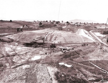
Album - Hume Reservoir Australia Album - Earth embankment on Victorian side from Top of Tail Tower Pillar, August 1927
This set of photos is from a leather bound album bearing the inscription "HUME RESERVOIR AUSTRALIA" plus 'The Rt. Hon. L. C. M. S. Amery, P. C., M .P.' all inscribed in gold. It was presented to The Rt. Hon. L. C. M. S. Amery, P. C., M. P, Secretary of State for Dominion Affairs on the occasion of his visit to the Hume Reservoir on 2nd November 1927. This album is of local and national significance as it documents the planning and development of the Hume Reservoir up to 1927. It was the largest water reservoir in the British Empire. The album records the pioneering engineering work that went into its construction.DEPARTMENT OF PUBLIC WORKS, N.S.W. RIVER MURRAY WATERS SCHEME. HUME RESERVOIR. 31. View from Top of Tail Tower Pillar - Earth Embankment, Victoria. This is a general view of the embankment which is being constructed by the Victorian Constructing Authority. The bank at its base is about 650 feet wide and it is about half its ultimate height. In the middle is the reinforced concrete core wall. At about the natural surface a tunnel for drainage and inspection purposes is built along the downstream side of the core wall but this cannot be seen. The Victorian workshops and township are located on the high ground beyond the embankment. The embankment curves round to the left at the side of the valley and will eventually block the gulley where the bushy tree stands. Access to one of the cuttings from which material is being got for the embankment is gained by means of this gulley at present. Part of another cutting may be seen on the right hand side at the back. August 1927.hume reservoir australia, river murray waters scheme, hume reservoir construction -
 Wodonga & District Historical Society Inc
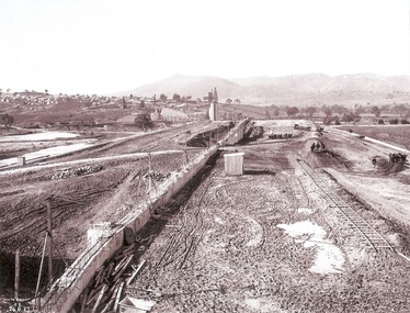
Album - Hume Reservoir Australia Album - Earth embankment, Victoria, August 1927
This set of photos is from a leather bound album bearing the inscription "HUME RESERVOIR AUSTRALIA" plus 'The Rt. Hon. L. C. M. S. Amery, P. C., M .P.' all inscribed in gold. It was presented to The Rt. Hon. L. C. M. S. Amery, P. C., M. P, Secretary of State for Dominion Affairs on the occasion of his visit to the Hume Reservoir on 2nd November 1927. This album is of local and national significance as it documents the planning and development of the Hume Reservoir up to 1927. It was the largest water reservoir in the British Empire. The album records the pioneering engineering work that went into its construction.DEPARTMENT OF PUBLIC WORKS, N.S.W. RIVER MURRAY WATERS SCHEME. HUME RESERVOIR. 32. Earth Embankment, Victoria. Looking down on the earth embankment and core wall. The earth is conveyed to the bank by rail, tipped out and then put in place by wheeled scoops, the horses and wheels treading and rolling the material into a very compact form while hoses play water on the mass to keep it moist. The concrete pillar with Tail Tower, and North Wing Wall, look very small in the distance. August 1927.hume reservoir australia, river murray waters scheme, hume reservoir construction -
 Wodonga & District Historical Society Inc
Album - Hume Reservoir Australia Album - Concrete Slabs on embankment, August 1927
This set of photos is from a leather bound album bearing the inscription "HUME RESERVOIR AUSTRALIA" plus 'The Rt. Hon. L. C. M. S. Amery, P. C., M .P.' all inscribed in gold. It was presented to The Rt. Hon. L. C. M. S. Amery, P. C., M. P, Secretary of State for Dominion Affairs on the occasion of his visit to the Hume Reservoir on 2nd November 1927. This album is of local and national significance as it documents the planning and development of the Hume Reservoir up to 1927. It was the largest water reservoir in the British Empire. The album records the pioneering engineering work that went into its construction.DEPARTMENT OF PUBLIC WORKS, N.S.W. RIVER MURRAY WATERS SCHEME. HUME RESERVOIR. 33. Concrete Slabs on Embankment. The upstream face of the embankment is being protected from the effects of wave action by concrete slabs 12 inches thick laid in squares in situ. The thrust at the toe of the bank is taken care of by a body of granite blocks and spalls. Victoria. August 1927.hume reservoir australia, river murray waters scheme, hume reservoir construction -
 Wodonga & District Historical Society Inc
Photograph - Bank of New South Wales, Wodonga
The first Bank of New South Wales building in Wodonga was located in a small cottage. The branch opened on 7 May 1872. At first it was conducted as an agency of the Beechworth branch. In October 1872 premises in Sydney road were purchased from Mr P. L. M. S. Chauncy for £650. When the bank commenced in the cottage the first account was opened in the name of Hillerman & Co, storekeepers, Wodonga. Another early account was in the name of William Huon, squatter of de Kerilleau, Wodonga. On 9 July 1873, the agency was converted into full branch under the management of Mr. Joseph Belcher. Other early accounts included Cronin & Callaghan, storekeepers; John Bassett Jnr, shoemaker; John Jennings, contractor; Ah Soon, tobacco grower, Kergunyah; John de Corney Ireland, collector of customs; Andrew Kyle, fellmonger; Rowan Lockhead, accountant; Alexander McKay, publican; George Pollard, farmer; Thomas Street, farmer; and Edmund Uren, gentleman, Buninyong. Organisations banking at the branch included Wodonga Building Society, 1873; Wodonga Mechanics Institute 1875; Wodonga Band Fund 1882; Talgarno Athenaeum, 1888; Talgarno Butter & Cheese Factory 1892; Wodonga Federation League 1893; Wodonga Brass Band 1895; Wodonga Benevolent Society 1895; Wodonga Fire Brigade 1897; Wodonga Rifle Club and Wodonga Racing Club in 1899 and Kiewa Polo Club in 1900. There were also numerous lodge and church accounts. The cottage was later renovated with a porch added in 1889 and an extension to the residence in 1898. The original house was eventually demolished to make way for a new bank and manager’s residence in Sydney Road in 1906. That building was again remodelled in 1969. It became a branch of the WESTPAC bank when the Bank of NSW and CBA Bank joined to become the Westpac Banking Corporation in 1982. After the building ceased operation as a bank, it has been the home to several businesses including a video store, a travel agency and a clothing store.These images have local significance as they record changes to a building which filled an important role in the commercial life of Wodonga.A series of photos both black and white and coloured which document changes in the former Bank of New South Wales building in Wodonga over time.Photo 1: On sign above verandah "BANK of NEW SOUTH WALES" Photo 2: On sides of building and above door: "BANK OF NEW SOUTH WALES" Photo 3: Above door: "HIRE/ VIDEO MADNESS/ SALES" Photo 4: Above door: "WODONGA TRAVEL"wodonga businesses, banking wodonga, bank nsw wodonga, businesses high street wodonga -
 Wodonga & District Historical Society Inc
Photograph - The River Port of Red Bank
THE RIVER PORT OF REDBANK During the 1870s, Red Bank would have been one of the busiest ports on the Murray River. When the railway line was being built from Melbourne to Wodonga all the railway material was brought up river from Echuca by paddle steamer and barge and unloaded at Red Bank. The material was loaded onto horse teams or bullock wagons and taken along the route of the spur line. During the 187 MacCulloch & Co. handled 3000 tons of railway material here' The port was operational from approximately 1870 until 1874. THE FIG TREES The fig trees and a small bank of gravel are the only visible reminders of where the spur line from the wharf at Red Bank met the main line. It was at this point that all the material for the mainline was transferred from the small locomotives and wagons from Red Bank. It would have been carried by bullock wagons and horse teams and unloaded at different places as the line progressed. After the line was completed in 1873 the fettlers from Wodonga would patrol this length of the line.These images are significant because they document an important stage in the development of transportation in North East Victoria.Images of the River Port of Red bank near Wodonga on the Murray River. 1. The wharf 2. All that remainsred bank port, historic wharf wodonga, river transport -
 Wodonga & District Historical Society Inc
Map - Boorgunyah - "The Town that never was"
At the height of the river trade, there was a town surveyed and laid out, and streets were named. This town was to house the workers at the river port of Red Bank when the paddle steamers plied the Murray River as far as Albury, carrying produce such as wool and wheat to the various towns along the river in the 1800s. As the river trade died away, this town never went ahead – one might say, “The town that never was.” A lone gum tree stands on the site today.This item is significant because it documents plans which were made for the early development of Wodonga.A black an white map depicting the proposed location of the township. The map is based on a sketch and is not to scale,early wodonga, boorgunyah - "the town that never was", wodonga heritage -
 Wodonga & District Historical Society Inc
Album - Ringer's River by Des Martin - Plate 31 - Rescuing Erin
Tommy Yarramin and his sister Ruby see Erin's exhausted body in the head of a tree near Barmagulla in the morning. Tommy brings her to the bank and they take her to their hut where their mother, Pulcherry Cherry, cares for her. Wary of white men's ways the aboriginals keep her presence a secret. P. "Darby", Ketchup as Tommy Yarramin.The album and images are significant because they document literature written by a prominent member of the Wodonga community. The presentation of this precis was supported by several significant district families and individuals.Ringer's River Album Coloured photo Plate 31des martin, many a mile, ringer's river, northeast victoria stories -
 Wodonga & District Historical Society Inc
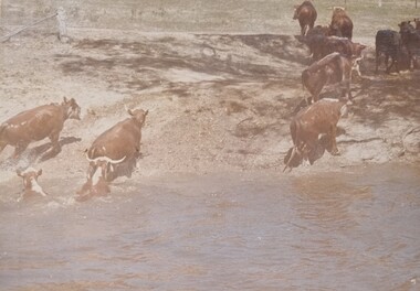
Album - Ringer's River by Des Martin - Plate 30 - Cattle cross the river to New South Wales
When morning comes all the cattle have struggled back to N.S.W. and the Victorian police find their trap is empty. O'Day, though he has lost his horse, makes it to the far bank some 400 yards downstream. Of Erin and Keiran there is no sign.The album and images are significant because they document literature written by a prominent member of the Wodonga community. The presentation of this precis was supported by several significant district families and individuals.Ringer's River Album Coloured photo Plate 30des martin, many a mile, ringer's river, northeast victoria stories -
 Wodonga & District Historical Society Inc
Album - Ringer's River by Des Martin - Plate 4 - O'Day's appointment announced
Back at the station MacLough announces to the assembled men that O'Day is now manager of Gooloora, with absolute power to hire, fire, buy, or sell, until he personally decides otherwise. He then has O'Day drive him to Overton where he repeats this to the bank manager, and arranges ample credit for the 20 year old executive before catching his train to the city.The album and images are significant because they document literature written by a prominent member of the Wodonga community. The presentation of this precis was supported by several significant district families and individuals.Ringer's River Album Coloured photo Plate 4 Back at the station MacLough announces to the assembled men that O'Day is now manager of Gooloora, with absolute power to hire, fire, buy, or sell, until he personally decides otherwise. He then has O'Day drive him to Overton where he repeats this to the bank manager, and arranges ample credit for the 20 year old executive before catching his train to the city.des martin, many a mile, ringer's river, northeast victoria stories