Showing 901 items matching "bluestone"
-
 National Wool Museum
Sale notice, "Darriwill"
Sale notice lists property as belonging to the Hope family for the last 100 years, who were the original owners. The property contains a bluestone house, stables, a carpenters shop, two cottages, working ammenities, all fronting the Moorabool River and Sutherland Creek. Notice was used in the NWM Woolbrokers office display.sheep stations - history property sales wool brokering, dennys, lascelles limited strachan and co. limited, hope, mr alistair, sheep stations - history, property sales, wool brokering -
 Melton City Libraries
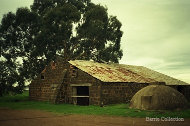
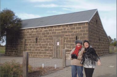
Photograph, Darlingsford Barn, Unknown
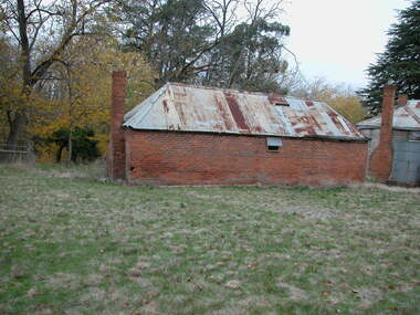
In 1853, Thomas Bell Darling purchased 176 acres from the Toolern Creek to Ferris Road. A house and bluestone barn/stables were built. The property was owned by Ralph Parkinson, followed by Richard Manning. “Darlingsford” was the name given to the Homestead. In 1911, Charles Ernest Barrie purchased the property known as“Darlingsford”. Barn before restorationlocal identities, local architecture, council -
 Sunbury Family History and Heritage Society Inc.
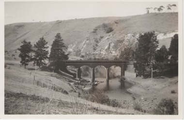
Photograph, 27 June 1934
This is a photograph of the bridge in the Bulla township which spans the Deep Creek, a tributary of the Maribyrnong River. It has been constructed from bluestone which is found across the volcanic western plains in Victoria. Kaolin was quarried from the cliff face in the background and was used in the making of bricks and pottery products manufactured at Northcote and Brunswick potteries.This is one of the many notable bluestone bridges which were built in the district in the nineteenth century.A black and white photograph of a valley with a five arched bridge spanning a river. There are high cliffs in the background.bulla township, deep creek, bridges -
 Ballarat Tramway Museum
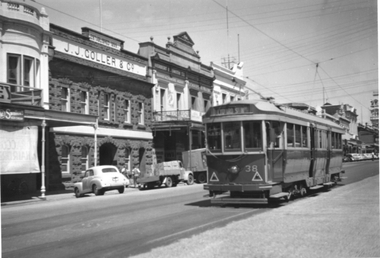
Photograph - Tram 38 Lydiard St Nth, mid 1950s
The photograph shows SEC Ballarat tram No. 38 outbound in Lydiard St North, Ballarat. The tram has large reflective triangles on the front that were added during 1956. In the background is the bluestone building of J J Coller & Co and other buildings on the east side of the street. Photographer and date unknown - mid-1950s.Yields information about tram 38 and Lydiard St North Ballarat.Black and White print on plain paper.tramcars, tram 38, lydiard st nth -
 Ararat & District Historical Society (operating the Langi Morgala Museum)
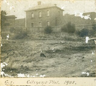
Photograph
Record of local historyA series of three black and white photographs of the Citizens Plot at Alexandra Gardens. 501 shows the bluestone building J Ward standing behind a wooden picket fence with bare earth in front. 502 shows men in suits standing with three horses attached to two wagons with large trees in the background. 503 shows plants that have grown in the Citizens Plot garden.501: Citizens Plot 1908 502: Citizens Plot 1909. 503: Citizens Plot showing growth 1921. -
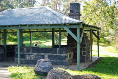
 Bendigo Historical Society Inc.
Photograph - BENDIGO HISTORICAL SOCIETY COLLECTION: BLUESTONE BUILDING REDESDALE
Colour photograph of bluestone building, with iron roof, Redesdale. Facade has one door and slit type openings in brickwork. No Chimney visible in image. Building possibly a stable associated with Redesdale Hotel. Image taken during BHS tour of the region. Coral Evans and one unnamed woman on LH side of image. Women are wearing winter clothing, scarves and hat. -
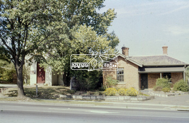
 Hume City Civic Collection
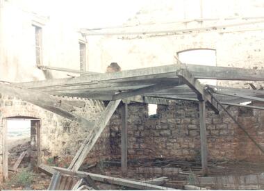
Photograph
Rosenthal Winery in Vineyard Road, Sunbury was one of the first wineries established in the area. It was owned by R. F. Kurrle. The roofless building still stands on the property which was part of the dairy farm owned by Tom and Angela Millett. The last vintage from the property was crushed in 1910.A coloured photograph of shell of the interior of the Rosenthal Winery. The bluestone is exposed on the lower half of the walls but the walls on the upper storey have either been rendered or painted. Part of the interior wooden structure is still standing. There is an open doorway on the LHS with two windows above it. Two smaller windows are on the lower part of another wall with a larger window above them. The building is roofless.rosenthal winery, wineries, vineyards, vineyard road, sunbury wineries, kurrle, r. f., millett, tom, angela, sunbury, george evans collection -
 Buninyong & District Historical Society
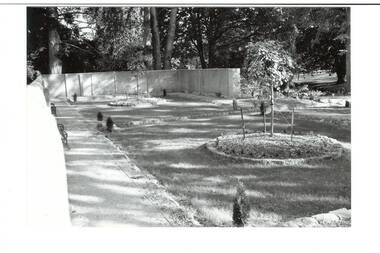
Photograph - B/W photograph, Clive Brooks, Old Swimming Baths, Buninyong Botanic Gardens, 9 April 1994
Shows restoration of old swimming baths, and conversion to enclosed garden work completed.B/W photo of old Swimming Baths in Buninyong Botanic Gardens, constructed by Shire Engineer C P Wilson c 1919 around existing pool. Photo taken during refurbishment/conversion to walled garden. Old baths filled in, sunken lawn established, 2 round garden beds in place and planted, bluestone edging, two benches just visible..buninyong, swimming baths, botanic gardens, c p wilson -
 Glenelg Shire Council Cultural Collection
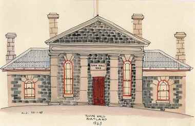
Painting, Town Hall, Portland, 21/01/1948
Watercolour, front view of Town Hall, Portland, off-white mount, black matte wooden frame, reflective glass, silver hanging wire on back. A bluestone building with four chimneys. Centre building with one smaller wing either side. Red/brown front door. Two long windows either side. Each wing also has a smaller window.Front: 'K.J. 27.1.48' - hand written, black ink, bottom left hand corner of painting 'TOWN HALL PORTLAND 1863' - hand written, black ink, bottom centre of painting Back: Black stamp centre. 'K.W.D, Jack P/L P.O. BOX 1, Doreen, Vic, 3754portland town hall, kenneth jack -
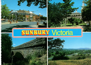 Sunbury Family History and Heritage Society Inc.
Postcard, Newcolourvue Productions Pty.Ltd, Sunbury Victoria, c1970s
The four photographs on the post card are well-known places in the town. They are the 1930s Royal Hotel building which was build on the same site of the original building on the corner of Evans and Brook Streets, Rupertswood Mansion, built 1874-45, the historic bluestone road bridge over Jacksons Creek and a view of the township in the 1970s taken from Francis Boulevard.The four views of Sunbury give an overview of the township in the 1970s before the increased development took place from the 1980s onwards.A coloured collection of four non-digital photographs of places in Sunbury in post card format. The edges of the post card are rippled. the back of the card gives details of the places as well as the maker.Sunbury Victoriaroyal hotel, rupertswood mansion, bluestone road bridge, sunbury, post cards -
 Eltham District Historical Society Inc
Slide - Photograph, Former Elltham Courthouse and Police Residence, c. Feb. 1989
The bluestone blocks were originally part of the bluestone lockup located behind the Police Residence and Courthouse. The stones at one stage formed an edging to a grass island at the intersection of Wattletree Road and Main Road and were painted white. When that intersection was reconstructed the stones were brought back to the former residence, occupied by the Shire Department of Parks and Environement where again they were used as edging for a newly constructed driveway put through from Main Road through where the original Police Station was sited. The stones now form part of the garden bed edging at the rear of the building. At some stage in 1989 a reproduction Police Station was built beside the residence as originally located, for the purpose of providing a lunch room for shire staff. The residence has been the home of the Eltham District Historical Society and Local History Centre since 2008. 35mm colour positive transparency (1 of 8) Mount - Agfa CS System grey 8 dots728 main road, eltham, eltham courthouse, local history centre, police residence, parks and environment, shire of eltham -
Glen Eira Historical Society
Letter - Kooyong Road, 415, Elsternwick
Two items about valuation of this property: 1/Typed letter dated 28/01/1977 from the Perpetual Executors and Trustees Association fo Australia Limited by Trust Officer RM Morrison to WV Scott of SP Simmond’s estate agents regarding the report and evaluation for the Sir Hugh Gerner Brian estate located at 415 Kooyong Road Elsternwick, included certificate of title. 2/Copy of typed letter by valuator WV Scott with details of the external and internal condition and valuation of the property with handwritten note,s dated 08/02/1977.kooyong road, elsternwick, brain hugh gerner sir, brain lady, land values, brick houses, bluestone -
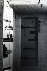 Federation University Historical Collection
Photograph - Photograph - Black and White, Geoff Biddington, Ballarat Gaol Cell Door, 1967
The Ballarat Gaol Cell Block was situated at the end of Lydiard Street South. It was demolished c1968Black and white photograph of a heavily riveted gaol cell door with large bolts..ballarat gaol, cell door, hinge, bluestone, geoff biddington, cell block, bolt -
 Ballarat Heritage Services
Photograph - Image - Colour, Clare Gervasoni, Ercildoun Workers Cottage, 2008, 10/05/2008
The photograph was taken during an opening on Ballarat Heritage Weekend. Colour image of a brick workers building on the Ercildoun property established by squatters the Learmonth Brothers. architecture, garden, bluestone, ballarat heritage weekend, ercildoun, ercildoune, workers cottage -
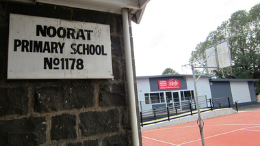 Ballarat Heritage Services
digital photographs, Lisa Gervasoni, Noorat Primary School, c2010-2017
Colour photograph of Noorat Primary School.building, noorat, bluestone, heritage, primary school, school, noorat primary school -
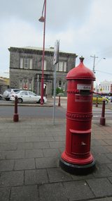 Ballarat Heritage Services
Digital photograph, Lisa Gervasoni, Portland, Victoria, c2015
Colour photorgraph of an old, red pillar box in Portland. portland, heritage, building, bluestone, shops, pillar box, letter box -
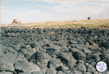 Port Fairy Historical Society Museum and Archives
Photograph
South Beach Development looking from rocks to Mal Dorea’s housesouth beach, development, rocks, bluestone, mal dorea, house, building -
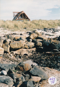 Port Fairy Historical Society Museum and Archives
Photograph
South Beach Development looking toward Mal Dorea’s new house from the beach Coloured photograph of rocks and drain on beach looking at unfinished A framed house in backgrounsouth beach, development, mal dorea, house, building, bluestone, beach -
 Ballarat Heritage Services
Photograph - Digital photographs, L.J. Gervasoni, Infant Jesus Catholic Church Koroit, 2011-2016
http://vhd.heritagecouncil.vic.gov.au/places/69285 " ... the foundation-stone of the new church at Koroit was laid by Bishop Goold on New Year's Day, 1867. It was said of Fr. Parle that his one. fault was "extravagant ideas of church building," and to his vision must be attributed what was called at the time "the most magnificent and costly ecclesiastical building in the Western District." Altogether about £6000 was spent on the Koroit church, a large sum in those days. It entailed much delay while the money was being collected, and Fr. Parle did not live to see the completion of the great work he had undertaken. .. " (The Advocate, 13 August 1947.) Digital images of a funeral congregation at Infant Jesus Catholic Church in Koroit, Victoria. church, catholic, koroit, infant jesus, exterior, presbytery, bluestone -
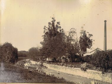 Bendigo Historical Society Inc.
Photograph - HUSTLERS ROYAL RESERVE MINE, BENDIGO CREEK
Sepia image mounted on board: image shows Bendigo Creek, sandstone walls on creek. Creek is not yet paved with bluestone pitchers. On RH side Hustlers Royal Reserve Mine, chimney and poppet head visible. Poppet head has lattice girder legs. Post Office clock behind showing 25 to 4. Image is pre-1910, when mine structure was removed.bendigo, mining, hustlers royal reserve/bendigo creek, bendigo, sandhurst, bendigo creek, mining, huslters royal reserve, post office, poppet head, chimney -
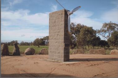 Bendigo Historical Society Inc.
Photograph - BENDIGO HISTORICAL SOCIETY COLLECTION: DUIGAN BROTHERS MEMORIAL MIA MIA
Colour photograph of the bluestone memorial erected to celebrate the first flight of an aeroplane by the Duigan brothers, Mia Mia/Baynton area The memorial has an aeroplane propeller attached at the top. . The first flight on an Australian made aeroplane was made by John Robertson Duigan on 16th July 1910, on the family property 'Spring Plains' Mia Mia. Photo taken during a BHS tour, possibly 1990's.aviation, civilian, duigan brothers -
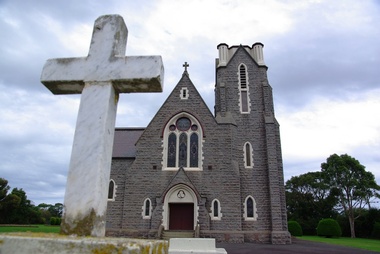
 St James Old Cathedral
Cathedral Building, St James Old Cathedral, 09/11/1839
St James Church, "Church of the Pioneers", was the first Church, first Anglican Church, and is the oldest building in Melbourne. The foundation stone was laid in 1839 by the Superintendent of the District of Bourke, Charles La Trobe, later Governor of the Colony of Victoria. The Church was opened in 1842 and the first Bishop Charles Perry was installed in the Cathedral in 1848 when its status changed to that of Cathedral. Its status changed back to that of a Parish church after 1891 when St Paul's Cathedral in Swanston Street was opened. St James is known as the "Church of the Pioneers" as it served as the place of worship, marriage, baptism and burial of many of the first families in the District of Bourke and the Colony of Victoria. St James Old Cathedral is of the most important historic value to the community of Victoria and to the Australian nation as the first Anglican Church founded within 4 years of the settlement of Melbourne. It represents and conserves the very earliest history of white settlement in Victoria and preserves the church associated history of the Pioneer families of Victoria in its collection of original records and artefacts. Late Neo-Georgian style stone church building with bluestone footings. Octagonal upper one storey bell tower housing eight bells supported by two storey square towers. Body of church has sloping roof and 4 stained glass ornamental windows on each of west and east sides with decorative sanctuary window to the north. Decorative Portico with columns on the north outside elevation. National Trust Commemorative plate on outside wall to right of east entry door. -
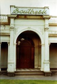 Kew Historical Society Inc
Photograph, Entrance to ‘Southesk’, Cotham Road, 1970
Colour enlargement of a photograph (slide) of Southesk (formerly Ordsall) in Cotham Road, Kew (demolished 1970).Rare colour photograph of the exterior of SoutheskA colour enlargement of the entrance to ‘Southesk’. Formerly known as ‘Ordsall’, the house was built for John Halfey in 1882 on the corner of Cotham Road and Charles Street. This Italianate mansion was built in the Renaissance villa style on a bluestone plinth. The picture provides photographic evidence of the tiling on the veranda and the typically arched doorway. The neon sign above the door was added during the period when it was owned by the City of Kew (1948-70).david carnegie, john halfey, southesk - cotham road - kew (vic), ordsall - cotham road - kew (vic) -
 Surrey Hills Historical Society Collection
Photograph, 181 Union Road, home of Mr and Mrs Antonio Clota
The house was built in 1910. The Clota and Sans families were part of a group of families of Spanish (Catalan) background who lived around Surrey Hills, many of whom are buried in Box Hill Cemetery. The house was built for Antonio and Josepha Clota and passed on to their daughter Josephine Sans and her family. Antonio's full name: Antonio Eusebio Miquel CLota (1869-1940; died Surrey Hills) had 3 brothers who came to Australia with him. Louis Clota (1864-1925); Marcus Clota (1866-1940) died Surrey Hills; Eusebio Clota (1869-1919). Their parents remained in Spain. Josephine Clota and Kim Sans had photos taken on the front entrance to the house when they were married on 9 May 1919. The wedding was reported in Punch.Black and white photo of the home of Mr and Mrs Antonio Clota; later the home of their daughter Josephine and son-in-law, Kim Sans and family. It shows bluestone curb and channelling in Union Road and a substantial wire mesh fence. The street tree looks like a plane tree and is a relatively young plant. Ther house is single storey brick with a tile roof and solid pillars supporting the verandah.houses, antonio clota, josepha comellas, josepha clota, catalan families, josephine clota, josephine sans, kim sans, joaquim sans, francis clota, frank clota, box hill cemetery -
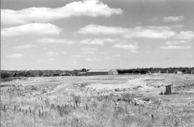 Darebin Parklands Association
Rockbeare Park 1970s, 1973-1980
B&W photograph of the area which was to become the Darebin Parklands. Shows tip site and makeshift toilet probably from the days of the former bluestone quarry. Darebin Enterprise Centre is in the distance. This item and all other Darebin Parklands Association archival material is now held by State Library Victoria (Accession No: YMS 13746). Please contact State Library Victoria if access is required. -
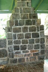
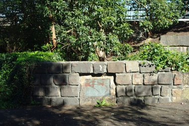
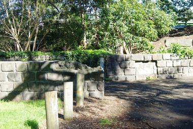
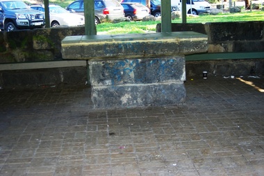 Greensborough Historical Society
Photograph - Digital Image, Pioneer Reserve 2014 -2, 01/10/2014
Pioneer Reserve, Greensborough is a small park on the corner of St Helena and Diamond Creek Roads. It is adjacent to the site of Greensborough's first bridge across the Plenty River, c. 1864 - 1960s. The shelter, viewing platform, retaining wall and entrance are built from the bridge's massive bluestone arched abutments dismantled between 1974 and 1983. Photograph by Marilyn Smith 2014.Digital copy of colour photograph.pioneer reserve greensborough -
 Greensborough Historical Society
Photograph - Digital Image, Pioneer Reserve 2014 -3, 01/10/2014
Pioneer Reserve, Greensborough is a small park on the corner of St Helena and Diamond Creek Roads. It is adjacent to the site of Greensborough's first bridge across the Plenty River, c. 1864 - 1960s. The shelter, viewing platform, retaining wall and entrance are built from the bridge's massive bluestone arched abutments dismantled between 1974 and 1983. Photograph by Marilyn Smith 2014.Digital copy of colour photograph.pioneer reserve greensborough -
 Greensborough Historical Society
Photograph - Digital Image, Pioneer Reserve 2014 -4, 23/09/2014
Pioneer Reserve, Greensborough is a small park on the corner of St Helena and Diamond Creek Roads. It is adjacent to the site of Greensborough's first bridge across the Plenty River, c. 1864 - 1960s. The shelter, viewing platform, retaining wall and entrance are built from the bridge's massive bluestone arched abutments dismantled between 1974 and 1983. Photograph by Marilyn Smith 2014.Digital copy of colour photograph.pioneer reserve greensborough -
 Greensborough Historical Society
Photograph - Digital Image, Pioneer Reserve 2014 -5, 23/09/2014
Pioneer Reserve, Greensborough is a small park on the corner of St Helena and Diamond Creek Roads. It is adjacent to the site of Greensborough's first bridge across the Plenty River, c. 1864 - 1960s. The shelter, viewing platform, retaining wall and entrance are built from the bridge's massive bluestone arched abutments dismantled between 1974 and 1983. Photograph by Marilyn Smith 2014.Digital copy of colour photograph.pioneer reserve greensborough -
 Greensborough Historical Society
Photograph - Digital Image, Pioneer Reserve 2014 -6, 23/09/2014
Pioneer Reserve, Greensborough is a small park on the corner of St Helena and Diamond Creek Roads. It is adjacent to the site of Greensborough's first bridge across the Plenty River, c. 1864 - 1960s. The shelter, viewing platform, retaining wall and entrance are built from the bridge's massive bluestone arched abutments dismantled between 1974 and 1983. Photograph by Marilyn Smith 2014.Digital copy of colour photograph.pioneer reserve greensborough