Showing 33740 items
matching buildings/structures
-
 Hume City Civic Collection
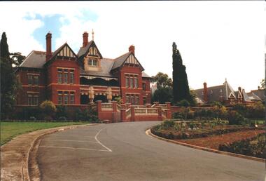
Photograph, mid 1980s
The building in the photograph was the main administrative building of the former Sunbury Asylum which was closed down in 1991. The buildings are now part of the Sunbury campus of the Victoria University of Technology.A coloured photograph taken from the eastern side of the curved approach to the main entrance of the former Sunbury Asylum. The photograph shows the two front wings and attic of the main administrative building and other buildings beyond the main building.sunbury asylum, victoria university of technology, george evans collection -
 Sunbury Family History and Heritage Society Inc.
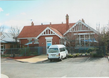
Photograph, c 2000
The building is the former Sunbury State School 1002, which was relocated to the former Industrial School in Jacksons Hill in 1999. The Federation Style building replaced an earlier school building in 1912 and it is now incorporated into the Sunbury Community Health Centre complex. A school in Sunbury has occupied the site on the corner of Macedon and Stawell Streets from 1870 to 1999. A coloured photograph of a red brick single storey Federation style building with an orange tiled roof. A white minivan is parked outside the building and a modern cream brick building is visible on the LHS of the photograph.sunbury state school no. 1002., sunbury community health centre -
 University of Melbourne, Burnley Campus Archives
Plan - Coloured plan, Plan of Burnley Gardens, 1929?
Layout of gardens, farm buildings, orchard, etc. overlaid on part of Lands Department map. See paper catalogue for full descriptionPart of larger plan (Lands Department Parish Plan). Partly hand-drawn. Area bounded by Yarra River, Swan St, Glen Iris railway line. Shows Burnley Gardens layout, handwritten amendments and explanation of existing and proposed structures including: Pavilion, sketch of unbuilt Administrative Building, poultry yard, contours of old orchard, sketch for Plant Research Institute, ditch, silo, milking shed, laying pens. See aboveburnley gardens, pavilion, burnley school of horticulture, farm buildings, poultry -
 Bendigo Military Museum
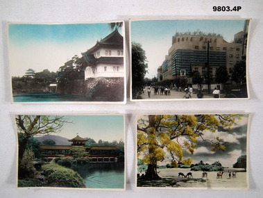
Photograph - PHOTOGRAPH, JAPAN
2. The Ernie Pyle Theatre was named after the American War correspondent who was killed in action during WW2. Part of the Bennetts Collection. See Catalogue No. 9726P for details of service for "Alva Marie Bennetts"., 1. Colour photograph of a Japanese style building facing a lake, second building in the background. White border around photograph. 2. Colour photograph of a street scene. Pedestrians on road fronting a multi story building. White border around photograph. 3. Colour photograph of a Japanese style building within a garden which features a lake. White border around photograph. 4. Colour photograph of a rural scene. Deer grazing in an open field. Large tree on LHS. White border around photograph.1. Handwritten in black ink on back: "The Imperial Palace". 2. Handwritten in black ink on back: Information explaining the naming of the building (Ernie Pyle Theatre).bennetts collection, alva bennetts, photographs, japan, ww2, ernie pyle. -
 National Wool Museum
Plan, Plan of Drainage for Dennys Lascelles Ltd
Plan for alterations to the drainage and plumbing of the Dennys Lascelles wool store (current building and demolished building).Drainage plan for Dennys Lascelles building, c.1920s. Detail of drainage plan for Dennys Lascelles building, c.1920s.PLAN OF DRAINAGE / for / Dennys Lascelles Lim. / (Messrs Laird & Buchan, Agents) / MUNICIPALITY: CITY OF GEELONGwool stores, dennys, lascelles limited laird and buchan, plans -
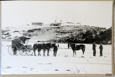 Flagstaff Hill Maritime Museum and Village
Photograph - Scene - Warrnambool, C. 1854-1871
This is an image of the Warrnambool Lighthouse Complex on Middle Island in 1854. The Store, Lighthouse Keeper's Quarters, Lighthouse and Flagstaff are in the background. The foreground shows a covered buggy drawn by two horses and a person in attendance, and another wheeled vehicle behind it with a figure nearby. There is a saddled horse to the right with two males in conversation nearby. The ground is soft, perhaps the riverbed or sandy shore. THE LIGHTHOUSE KEEPERS Lighthouse Keepers were responsible for keeping their Lighthouse’s lights shining at night. They kept a lookout for passing vessels and changes in weather. They were expected to clean, polish and maintain the equipment and buildings. They kept regular and detailed records of who was on watch, and the time the light was lit, trimmed and extinguished. They kept a journal about other events that occurred. They keep regular, accurate Meteorological Logs. It was expected that they were competent in Morse code signalling. They would be called to help in times of disasters and shipwrecks and to give official statements about these events. Many Lighthouse Keepers also volunteered as members of the lifeboat crew. The Lady Bay lighthouses were officially classified as small, so the Keepers had the official titles of Senior Assistant Lighthouse Keeper and Assistant Lighthouse Keeper. They were employed by the Public Service and paid rent to live in the Lighthouse Quarters. They were compulsorily retired at the age of 60, with most receiving a superannuation payment. Despite their time-consuming duties, there was time to follow hobbies and crafts such as growing vegetables, playing musical instruments, making models of buildings including lighthouses, and crafting furniture pieces. An example of a keeper’s skills is the carved fire screen made by /assistant Keeper Thomas Hope in the late 19th century and displayed in the Lighthouse Keeper’s cottage at Flagstaff Hill. Both Alexander and Farncombe had served under Senior Keeper Robert Deverell, who was the first and only Senior Lighthouse Keeper at the Middle Island Complex. John Alexander was the Assistant Keeper in the 1850s. Andrew Farncombe was the last Assistant Keeper at Middle Island, serving there with his family from 1864 to 1871. During 1871 and 1872 the Lighthouse Complex was moved to Flagstaff Hill on Merri Street. Farncombe and Deverell then became the first Keepers and occupants of the Lady Bay Lighthouse Complex at Flagstaff Hill. They continued their service together; overall, Deverell served from 1859 to 1885 and Farncombe from 1864 to 1974. WARRNAMBOOL'S LADY BAY LIGHTHOUSE COMPLEX - The original Lighthouse Complex was built on Middle Island in 1858-1859 then transferred stone-by-stone to Flagstaff Hill in 1871. The Complex comprised the Lighthouse, the Lighthouse Keepers’ Quarters and a Privy. The bluestone Keeper’s Quarters was a cottage divided into two compartments, one for the Senior Keeper and his family, the other for the Assistant Keeper and his family. The bluestone Store was divided into three; a store, a workshop, and an oil store (or office). The Privy comprised a small building also divided into two separate, back-to-back toilets, one for each Keeper and his family. In the 1970s the Flagstaff Hill Planning Board was set up under the chairmanship of John Lindsay. The Board was to make recommendations to the Warrnambool City Council regarding the use of the buildings and the rest of the Crown Land on the site. The Flagstaff Hill Maritime Village opened in 1975 and began renovating the Cottage in stages, during which time evidence of a 1920s fire was found in the eastern section of the cottage. Additions of a porch on the west and a washroom on the east were made in the 1980s. The western part of the building is now a Shipwreck Museum and the east has returned to a late 19th-century Lighthouse Keeper’s cottage and includes the screen made by Assistant Lighthouse Keeper Thomas Hope in the late 19th century. Hope served two periods of time at the Lighthouse. This photograph is significant as a visual record of the original Warrnambool Lighthouse Complex on Middle Island, the origin of what is now the Lady Bay Lighthouse Complex. The photograph is significant for its connection to the Complex, which is now listed on the Victorian Heritage Register, H1520, for being of historical, scientific (technological) and architectural significance to the State of Victoria. The Complex is significant as an example of early colonial development. The photograph is significant for its connection with the important navigational function of the Lighthouses, a function still being performed to this day. The photograph is also significant as it shows an example of buildings organised by the Public Works Department in Victoria in the mid-to-late 19th century. The structures tare still stand strong. Photograph of horses, a buggy and three gentlemen in the foreground and the background shows a lighthouse and accompanying buildings. Printed in black and white. (Another two horse-drawn vehicles are partially visible). The subject is the Lighthouse Complex on Middle Island, Warrnambool, dated between 1854 and 1871.An inscription is handwritten in black pen on the back of the mounting board."The lighthouse and accompanying buildings were / established on Middle Island in 1854, as this / picture shows. In 1871 they were moved to their / present site on Flagstaff Hill."flagstaff hill, flagstaff hill maritime museum, flagstaff hill maritime village, warrnambool, maritime museum, shipwreck coast, lighthouse keeper's cottage, lighthouse residence, lighthouse, chart room, quarters, privy, middle island, beach lighthouse, obelisk, lighthouse complex, lady bay complex, warrnambool port, warrnambool harbour, lady bay, keepers, lighthouse keeper, upper lighthouse, lower lighthouse, assistant keeper, ports and harbours, cottage, meteorological record, 1854, 1871 -
 Federation University Historical Collection
Technical Drawing, Drawing of a Bridge Structure, 1924
Pencil on paper student's technical drawing of a bridge structure technical drawing, engineering drawing, g. murrowood, drawing of a bridge structure, bridge -
Glenelg Shire Council Cultural Collection
Photograph - Photograph - Lee Breakwater, Portland, n.d
Port of Portland Authority Archivesport of portland archives, lee breakwater, construction, tanker berth -
Whitehorse Historical Society Inc.
Pamphlet, Nunawading 1999 - a structure plan, 1988
City of Nunawading - plan for structure, operation of the city by 1999.City of Nunawading - plan for structure, operation of the city by 1999.City of Nunawading - plan for structure, operation of the city by 1999.town planning, city of nunawading -
Whitehorse Historical Society Inc.
Pamphlet, Burwood Heights update, 2006
Burwood Heights Activity Centre Draft Structure Plan.Burwood Heights Activity Centre Draft Structure Plan.Burwood Heights Activity Centre Draft Structure Plan.city of whitehorse, burwood heights -
Clunes Museum
Geological specimen - ROCK SAMPLES
Diamond sawn samples of basalt showing grain structureNilbasalt, geological specimens -
 Ringwood and District Historical Society
Photograph, Stables at old Police Station, 32 Mt. Dandenong Rd. built 1888
Black and white photograph of weatherboard structure with iron roof.Written on rear of backing sheet, "Stables at old Police Station, 32 Mt. Dandenong Rd. 1888. -
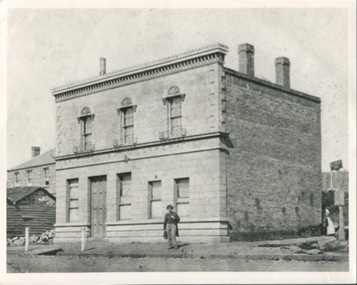
 Wodonga & District Historical Society Inc
Photograph - Codling Collection 01 - Wodonga Shire Hall
Miss Olive Codling was a Foundation Member and a Life Member of the Wodonga Historical Society. Many of her prize-winning photos are held in the Society Collection. She also held a range of roles and committee positions in a wide range of Wodonga community organisations. These included the Horticultural Society, the Wodonga Arts Council, the Wodonga Camera Club and the Wodonga Lapidary Club. Wodonga Shire was created in 1876 when the colonial government agreed to ratepayers' petitions to have their part of the local government district severed from the Yackandandah Shire to form a new municipality. After meeting for 14 years in rented premises, in the Prince of Wales Hall, Wodonga Council built its first Shire Hall on the corner of High and Elgin Streets in 1890. The date on the facade of the building represents the date of the formation of the Shire.This image is significant as it documents an important building and era in the development of local government in Wodonga.Wodonga Shire office at corner of High street and Melbourne Road Built 1876 demolished 1971 . Now the location of Woolworths shopping complex. Also incorporated the Melba Theatre On facade of building: " A.D. 1876"high st wodonga, wodonga local government, shire hall wodonga -
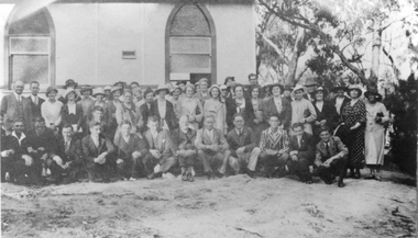 Stawell Historical Society Inc
Photograph, Pomonal Church on Opening Day 1935
Pomonal Methodist Church with group of people standing out the front of the building. Photograph taken on the day the church was opened in 1935. Financial aid from the Methodes Church enabled a building to be erected using voluntary labour. The first service was held by the Methodes' on Sunday Dec. 1st. 1935. Conducted by Rev. N. G. Graham of Stawell and the evening service by Rev. G. Fisher of Ararat. This building now used by United Church.Black and white photo of a building with a large group of people kneeling & standing to the right of the building. stawell religion -
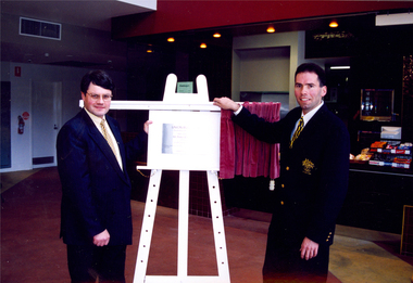 Federation University Historical Collection
Photograph, Opening of the Refurbished University of Ballarat Union Building (now Albert Coates Building)
Ballarat born Peter Blackburn graduated from the Ballarat University College with a Diploma in Teaching in 1991. At one time he was Australia's number one ranked doubles and mixed Badminton player, he represented Australia on numerous occasions, receiving a record three bronze medals in the 1994 Commonwealth Games. Peter Blackburn captained Australia's badminton team at the Atlanta Olympics.Phillip Candy, Peter Blackburn and Vice Chancellor David James and the opening of the refurbished Union Building (now known as the Albert Coates Centre). .1) Peter Blackburn, wearing an Olympic Games Blazer, addresses the audience .2) Phil Candy at the lecturn .3) A man, possibly David Fisken, at the lecturn. .4) Phil Candy (left) and Peter Blackburn beside the newly revealed plaque at the opening of the Mt Helen Union Building Refurbishment by Peter Blackburn. .5) Peter Blackburn get animated while addressing the audience. Phil Candy is standing to the left. The plaque in the photograph reads: " Union Building Redevelopment ... was opened by Mr Peter Blackburn ..."union building, albert coates centre, peter blackburn, phil candy, david james, plaque, olympics, olympian -
Federation University Historical Collection
Equipment - Scientific Object, Test Tube Holder
This item was removed from the Mt Helen Campus S-Building before refurbishment in September 2015.A wooden test tube holder. It has cut circles in the structure to hold upright test tubes (those in use) and pieces of dowel to hold upside down test tubes (those in storage or drying). The word ananlite is engraved in the wood at the front. There are pen markings of numbers next to some of the holes and some of the pieces of dowel. The words water and lime are also written in pen, with arrows pointing towards, next to one of the end holes. test tube holder, test tubes, science, scientific equipment, laboratory -
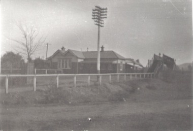 Sunbury Family History and Heritage Society Inc.
Photograph, c.1910
The building in the photograph is the Sunbury Railway Station in Brook Street and before it underwent renovations and externaL changes.The establishment of the railway in Sunbury in 1859 was an important development in the town's history and fore the Bendigo regional rail network.A black and white photograph of a weatherboard building behind a post and rail fence with a tall power pole in front of the building. A roadway is in front of the building.sunbury railway station -
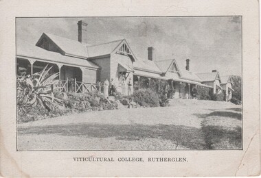 Rutherglen Historical Society
Postcard, 1910-1920 (Approximate)
Unframed black and white photograph of a long weatherboard building with verandas across much of the front.Printed below photograph: "Viticultural College Rutherglen" On message side of postcard: "Secretary, Soldiers' Fathers' Assn., Manufacturers' Building, 312 Flinders St., Melbourne."viticultural college -
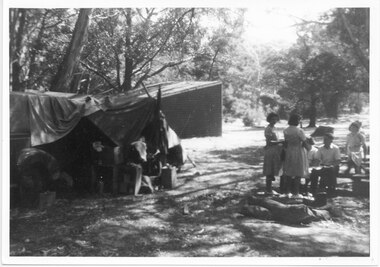 Halls Gap & Grampians Historical Society
Photograph - B/W, C 1940s
This is a photo of the Zumsteins camping area, which was popular with families.The photo shows a group of six people, two standing near, and four seated at, a picnic table. There is a large canvas tent/structure with boxes and tins at the entrance to the left and behind it there is a corrugated iron building. The area is surrounded by bush.recreation, camping, scenery, zumsteins -
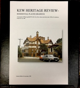 Kew Historical Society Inc
Archive (Sub-series) - Subject File, Kew Heritage Review, Residential Places Graded B, Volume 2, 1999, 1999
Graeme Butler & AssociatesProject FilesProvenance OrderBlack 4-Ring binder that includes research about, and an assessment of buildings previously graded B in the City of Kew Urban Conservation Study 1988 by Pru Sanderson Design Pty Ltd. The files were created by the heritage architect Graeme Butler and the paper files include maps, correspondence, title searches, readings, reviews of prior classifications, newspaper and journal articles, directories etc for each property assessed. graeme butler, heritage reviews - kew, 25 mary street, 4 merrion grove, 24 milfay avenue, 24 miller grove, 26 miller grove, 28 miller grove, 82 molesworth street, 27 princess street, 16 queen street, 20 yarra street, 84 walpole street, 118 walpole street, 11 wellington street, 83 walpole street, 25 wellington street, 8 yarra street, 33 wills street, 63 walpole street, 14 vista avenue, 89 studley park road, 12 tara avenue, 75 studley park road, 21 redmond street, 52 walpole street, 51 walpole street, 71 stevenson street, 34 rowland street, 21 stoke avenue, 34 stevenson street, 44 studley park road, 25 studley park road, 13 studley avenue, 2 second avenue, 11 second avenue, 3 second avenue, 36 stawell street, 12 stevenson streetgraeme butler, heritage reviews - kew, 25 mary street, 4 merrion grove, 24 milfay avenue, 24 miller grove, 26 miller grove, 28 miller grove, 82 molesworth street, 27 princess street, 16 queen street, 20 yarra street, 84 walpole street, 118 walpole street, 11 wellington street, 83 walpole street, 25 wellington street, 8 yarra street, 33 wills street, 63 walpole street, 14 vista avenue, 89 studley park road, 12 tara avenue, 75 studley park road, 21 redmond street, 52 walpole street, 51 walpole street, 71 stevenson street, 34 rowland street, 21 stoke avenue, 34 stevenson street, 44 studley park road, 25 studley park road, 13 studley avenue, 2 second avenue, 11 second avenue, 3 second avenue, 36 stawell street, 12 stevenson street -
 Kew Historical Society Inc
Archive (Sub-series) - Subject File, Kew Heritage Review, Residential Places Graded B, Volume 3, 1999, 1999
Graeme Butler & AssociatesProject FilesProvenance OrderBlack 4-Ring binder that includes research about, and an assessment of buildings previously graded B in the City of Kew Urban Conservation Study 1988 by Pru Sanderson Design Pty Ltd. The files were created by the heritage architect Graeme Butler and the paper files include maps, correspondence, title searches, readings, reviews of prior classifications, newspaper and journal articles, directories etc for each property assessed.graeme butler, heritage reviews - kew, 4 cameron court, 2 hodgson street, 20 fellows street, 26 fellows street, 23 highbury grove, kew lunatic asylum, kew mental hospital, willsmere, 36 stawell street, 13 studley avenue, 16 studley avenue, 20 studley avenue, raheen, studley park road, beament house, 33 uvadale road, 20 yarra streetgraeme butler, heritage reviews - kew, 4 cameron court, 2 hodgson street, 20 fellows street, 26 fellows street, 23 highbury grove, kew lunatic asylum, kew mental hospital, willsmere, 36 stawell street, 13 studley avenue, 16 studley avenue, 20 studley avenue, raheen, studley park road, beament house, 33 uvadale road, 20 yarra street -
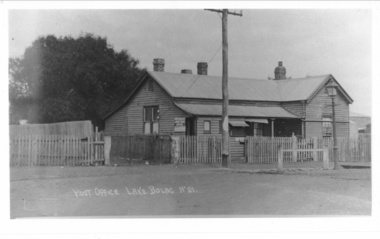 Lake Bolac & District Historical Society
Photograph - Black and white photograph, Lake Bolac Post Office - Glenelg Highway Lake Bolac c.1940s, c1940
Lake Bolac Post Office Glenelg Highway. Initially the Post Office was established at the Store in 1868. This official weatherboard building was opened in 1887 incorporating a telegraph office, money order office and post office savings bank. The Post Office business was relocated in 1944 and the building was used as a private residence with the front room leased to Dennys Lascelles. Note the horse hitching rail and kerosene street light.Photograph depicting a weatherboard building across a road. The building is fenced. In front of the building there is a telegraphic or electric post and a lamp post.lake bolac, post office, glenelg highway, dennys lascelles -
Creswick Campus Historical Collection - University of Melbourne
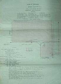
Document, unknown
School of Forestry existing services and condition plans, Building plans. Extension plansBuilding Plans -
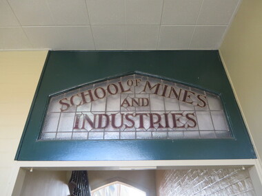 Federation University Historical Collection
Photograph, Stained Glass Windows at the Ballarat School of Mines Administration Building, 2015, 07/10/2015
This leadlight window was originally over the door of the Administration Building on SMB Campus. Colour photograph of a stained glass window in the Ballarat School of Mines Administration Building (Building A).ballarat school of mines, administration building, new classrooms, stained glass, lydiard street south, ballarat, architectual features, a building -
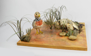 National Wool Museum
Artwork, other - Paper Taxidermy, Mary-Jane Walker, Plains Wanderer, 2020
The world’s most ecologically distinct bird lives in the native grasslands of Victoria - but only just. The plains-wanderer is a small bird that was once widespread across the grasslands of south-eastern Australia. Today there are fewer than 1000 mature birds in the wild. The plains-wanderer is under threat due to habitat loss caused by overgrazing, cropping and suburban sprawl. Unlike most other birds, female wanderers are larger and more colourful and the males take care of the chicks. They are only about 15cm tall and weigh between 40-80g for the male and 55-90g for the female. Their intricate plumage mirrors the colours of their grassland home so they blend in perfectly with their surroundings. The plains-wanderer’s origins date back to when Australia was part of the Gondwana supercontinent over 60 million years ago. They are so biologically distinct that their extinction would result in the loss of a branch of the tree of life. A fussy grass dweller, they like neither too much nor too little grass. That is where sheep grazing can help. After years of low numbers in Victoria, plains-wanderer populations have been increasing in Terrick Terrick National Park in north west Victoria, as sheep grazing maintains the grass in the park at a suitable level. With the right management, this ecologically important bird species is continuing to survive in the native grasslands of Victoria. Managing these habitats for the plains-wanderer can also support the conservation of many other threatened plant and animal species. Object: Nest of plains-wanderers by Mary-Jane Walker, 2020. Outer made from upcycled paper, internal structure steel. Nest of plains-wanderers by Mary-Jane Walker, 2020. Outer made from up cycled paper, internal structure steel. native grasslands, plains-wanderer, terrick terrick national park -
 Kilmore Historical Society
Photograph, Oriental Bank Corporation, 1866
This photograph was most likely taken for the 1866 Intercolonial Exhibition in Melbourne.25cm x 20cm black and white reproduction of a photograph of the Oriental Bank Corporation, 7 Sydney Street Kilmore, from the State Library of Victoria. Double storey building with decorative parapet along roofline, wrought iron balconets at upper storey windows, decorative hood molds above windows, name of bank in stone under ground floor cornice, a man standing on path in front of bank. Woman standing at back of building in shadow. A sign on post at back of building reads: Land for Sale Apply to W. Grace Solicitor Kilmore.Printed on back: REPRODUCTION RIGHTS RESERVED Copied by State Library of Victoria Tenders called for erection of this building in March 1864.banks, 19th century -
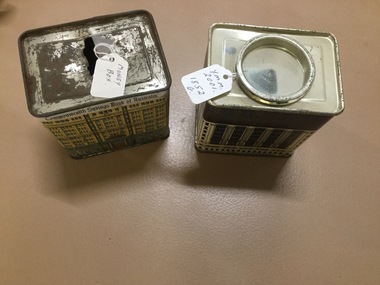 Yarrawonga and Mulwala Pioneer Museum
Money Box X 2
Tin - Produced by the Commonwealth Bank (Savings of Australia) . Two different patterns on the outside - appears to be of the bank building a) yellow & green colourings b) Maroon and yellow.On top on No 2- it has "This money box is a replica of the Commonwealth Bank Heritage Building 48 Marlin Place ,Sydney. -
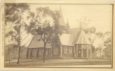 Bacchus Marsh & District Historical Society
Photograph, Holy Trinity Church Bacchus Marsh 1883
The Holy Trinity Anglican Church in this location was first opened in 1877. An earlier nearby prefabricated Church building known as the 'Iron Church' had served as the Anglican place of worship in Bacchus Marsh from around 1855 until 1877. The 1877 sandstone Church with a slate roof was intended as a permanent structure for Anglican worship in Bacchus Marsh and still stands in 2024 and continues to function as an Anglican Church. The building was designed by Frederick Wyatt and is described as early English Gothic in style. It was opened on 5 June 1877 by Bishop Moorhouse of Melbourne. The sandstone was acquired from Grant's quarry at Maddingley.Small sepia unframed photograph on card with gold border framing photograph. Housed in the Jeremeas Family Album, which contains photographs of Bacchus Marsh and District in 1883 by Stevenson and McNicoll. The photograph depicts the recently constructed Anglican Holy Trinity Church in Gisborne Road, Bacchus Marsh. The view of the building is from Gisborne Road looking west. From this angle the rear and southern side of the building can be seen. A picket fence along the entrance to the Church grounds can be seen in the foreground.On the front: Stevenson & McNicoll. Photo. 108 Elizabeth St. Melbourne. COPIES CAN BE OBTAINED AT ANY TIME. On the back: LIGHT & TRUTH inscribed on a banner surmounted by a representation of the rising sun. Copies of this Portrait can be had at any time by sending the Name and Post Office Money Order or Stamps for the amount of order to STEVENSON & McNICOLL LATE BENSON & STEVENSON, Photographers. 108 Elizabeth Street, MELBOURNE churches bacchus marsh, holy trinity anglican church bacchus marsh, holy trinity church of england bacchus marsh, stevenson and mcnicoll 1883 photographs of bacchus marsh and district -
Moorabbin Air Museum
Document - Wamira NIA E-1 Drawings and documents
-
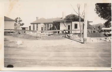 Sunbury Family History and Heritage Society Inc.
Photograph, Royal Hotel, 1936
The building being demolished in the photograph is the Railway Hotel which was destroyed by fire in 1936. It was decided to demolish the old building and rebuild a more modern hotel on the Brook/Evans Street corner where the old building had stood for 61 years.A non-digital black and white photograph with a cream border of a single storey building undergoing demolition. Two other buildings are visible on the site.royal hotel, brook street, evans street, hotels