Showing 597 items
matching circa 1900
-
 Trafalgar Holden Museum
Functional object - Weymouth bridle, Circa 1900
... Circa 1900 ...Bridle used on horses that pulled light carriages.ReplicaBlack leather straps, with metal fittings as neededS C, SHOW CRAFTbridle, leather, equine -
 Charlton Golden Grains Museum Inc
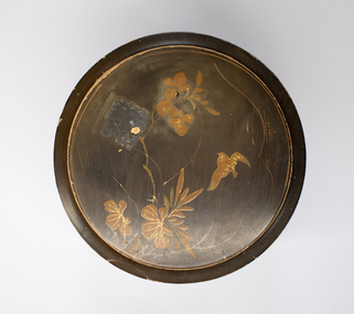
Container - Collar Box, Circa 1900
... Circa 1900 ...Round Veneer Wood Collar Box. Insect Design, Bird & Flowers. Place in centre for studs -
 Puffing Billy Railway
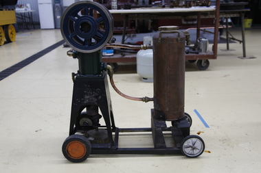
Heinrici Hot Air Motor, 1900s
... Louis Heinrici, Germany, circa 1900 a small Stirling type...-valley-and-the-dandenong-ranges Louis Heinrici, Germany, circa ...Louis Heinrici, Germany, circa 1900 a small Stirling type hot air engine in which a body of air is worked constantly, being alternately heated and cooled during each revolution of the crankshaft. Heinrici hot air engines are of the valveless, closed cycle type, generally called Stirling cycle engines, after Robert Stirling, the Scottish Presbyterian minister who pioneered their development in the early 1800's. They operate by alternately heating and cooling a quantity of air, called the working fluid, contained in the engine's internal spaces. Heat is applied externally and passes through the cylinder wall, heating the working fluid, which is then expanded against a piston to do mechanical work. After heating and expanding, the working fluid is moved to a cool space where it cools and contracts before being returned to the hot space for the cycle to repeat. It has a displacer (just a loose piston), below and in the same cylinder as the power piston to which it is connected via cranks and linkages so as to lead by 90degrees of crankshaft angle. The displacer space and the piston space are connected by the annular gap around the loose fitting displacer so that the working fluid moves between these spaces and changes volume by the appropriate ratio as the engine rotates. Because they have no valves and experience no sudden pressure changes, Stirling engines are noted for quietness and reliability. Heinricis use air at atmospheric pressure for their working fluid, but for higher specific output (power for size) and better efficiency, modern Stirling cycle engines use pressurised gas- air, nitrogen, helium or hydrogen.Historic - Hot Air Engine - MotorHot Air Motor made of Steel with two drive wheels. a small Stirling type hot air engine in which a body of air is worked constantly, being alternately heated and cooled during each revolution of the crankshaft. Heinrici Motorheinrici hot air motor, puffing billy -
 Eltham District Historical Society Inc
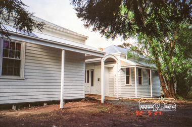
Photograph, Allwood House, Hurstbridge, Eltham Heritage Tour, 24 May 1992, 24/05/1992
... Mansion Gates - A Surviving Farm House - An Intact Circa 1900 Main... - Toorak Mansion Gates - A Surviving Farm House - An Intact Circa ...ELTHAM HERITAGE TOUR The Society excursion on 24th May 1992 was arranged by David Bick, leader of the team carrying out the Shire's heritage study. David selected a number of sites or buildings identified in the study, some of them lesser known components of the Shire's heritage. The tour commenced at the Eltham Shire Office at 10.00 am. Travel was by private car and mini-bus with stops at about twelve locations for commentary by David.It included a short walk in Hurstbridge and lunch at Kinglake. Highlights of the tour included: - 10 am Leave from Shire Offices - 3 Important Trees - A Physical Link to Eltham's First Settlers - Toorak Mansion Gates - A Surviving Farm House - An Intact Circa 1900 Main Street - First Settlers - Gold Miners, and Timber-getters - An Early Hotel - A Pioneering Homestead - Changing Eltham Shire - 20th Century - 4 pm Afternoon Tea and Finish Tour Extract from ELTHAM CULTURAL HERITAGE TOUR (Newsletter No. 85, July 1992, by Bettina Woodburn) "At the crossroads stands Allwood House with its well laid out garden. The original owners, the Hurst family, ran a nursery; the aligned palms, the cactus clumps, the introduced trees and shrubs show the plants then in fashion. On the other corners stand an old corrugated iron garage; a restaurant, designed and built 1980, but by using old materials it tries to retain the rustic character of its surroundings; and open space where a two storied Wineshop/Saloon once stood. The old Bank, now in the grounds of Allwood House has been moved a few doors down the street."Record of the Society's history and activities and highlighting various aspects of the Heritage Study undertaken by David Bick used to create the future heritage overlay for the Shire of Eltham and later Nillumbik Shire.Roll of 35mm colour negative film, 4 stripsKodak Gold 100 5095shire of eltham historical society, activities, heritage tour, hurstbridge, allwood house -
 Eltham District Historical Society Inc
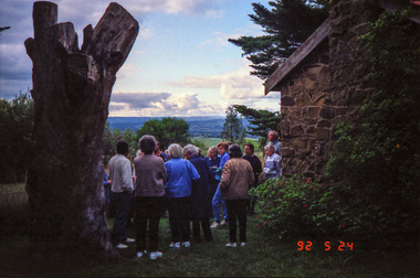
Photograph, Kangaroo Ground War Memorial, Eltham Heritage Tour, 24 May 1992, 24/05/1992
... Mansion Gates - A Surviving Farm House - An Intact Circa 1900 Main... - Toorak Mansion Gates - A Surviving Farm House - An Intact Circa ...ELTHAM HERITAGE TOUR The Society excursion on 24th May 1992 was arranged by David Bick, leader of the team carrying out the Shire's heritage study. David selected a number of sites or buildings identified in the study, some of them lesser known components of the Shire's heritage. The tour commenced at the Eltham Shire Office at 10.00 am. Travel was by private car and mini-bus with stops at about twelve locations for commentary by David.It included a short walk in Hurstbridge and lunch at Kinglake. Highlights of the tour included: - 10 am Leave from Shire Offices - 3 Important Trees - A Physical Link to Eltham's First Settlers - Toorak Mansion Gates - A Surviving Farm House - An Intact Circa 1900 Main Street - First Settlers - Gold Miners, and Timber-getters - An Early Hotel - A Pioneering Homestead - Changing Eltham Shire - 20th Century - 4 pm Afternoon Tea and Finish Tour Extract from ELTHAM CULTURAL HERITAGE TOUR (Newsletter No. 85, July 1992, by Bettina Woodburn) "Now we drove through stands of pines to the Kangaroo Ground Lookout Tower, a most unusual War Memorial, World War I. The tower and a shed/residence (it had a chimney) were built from local sandstone. Below to the south and east of Melbourne spread 'suburbia'. Close by the landscape seemed so contrived - English fields and hedgerows! Although only about twenty inches deep, the soil of this ancient volcano, its crater lost under subsequent weathering, was rich, deserving the name of "Garden Hill". Now native trees are taking over again. In Kangaroo Ground itself stand the inevitable Store, School and Church - and two Norfolk pines and a monkey puzzle tree."Record of the Society's history and activities and highlighting various aspects of the Heritage Study undertaken by David Bick used to create the future heritage overlay for the Shire of Eltham and later Nillumbik Shire.Roll of 35mm colour negative film, 4 stripsKodak Gold 100 5095shire of eltham historical society, activities, heritage tour, kangaroo ground, kangaroo ground tower, war memorials, kangaroo ground memorial -
 Eltham District Historical Society Inc
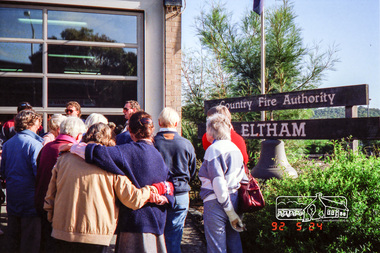
Photograph, Eltham Fire Station, Main Road, Eltham Heritage Tour, 24 May 1992, 24/05/1992
... Mansion Gates - A Surviving Farm House - An Intact Circa 1900 Main... - Toorak Mansion Gates - A Surviving Farm House - An Intact Circa ...ELTHAM HERITAGE TOUR The Society excursion on 24th May 1992 was arranged by David Bick, leader of the team carrying out the Shire's heritage study. David selected a number of sites or buildings identified in the study, some of them lesser known components of the Shire's heritage. The tour commenced at the Eltham Shire Office at 10.00 am. Travel was by private car and mini-bus with stops at about twelve locations for commentary by David.It included a short walk in Hurstbridge and lunch at Kinglake. Highlights of the tour included: - 10 am Leave from Shire Offices - 3 Important Trees - A Physical Link to Eltham's First Settlers - Toorak Mansion Gates - A Surviving Farm House - An Intact Circa 1900 Main Street - First Settlers - Gold Miners, and Timber-getters - An Early Hotel - A Pioneering Homestead - Changing Eltham Shire - 20th Century - 4 pm Afternoon Tea and Finish Tour Extract from ELTHAM CULTURAL HERITAGE TOUR (Newsletter No. 85, July 1992, by Bettina Woodburn) "Commencing with a quick walk to see the magnificent bell at the Eltham Fire Station, we then 'drove along Arthur Street. Here were examples of what constitutes the building environment of Eltham. Massed among the wattles and eucalypts were golden cypress and pines; No. 50 was an exotic 'old English' manor-house; No. 93 had bluestone gateposts, from Fenton Road Toorak (as with Montsalvat, using re-cycled building material was very much the trend); past the natural Reserve dedicated to the artist Walter Withers, a plaque on a huge boulder; and on both sides houses in the various modes - timber with wrought iron decor, brick-some more recent than others, decades of 'suburbia'."Record of the Society's history and activities and highlighting various aspects of the Heritage Study undertaken by David Bick used to create the future heritage overlay for the Shire of Eltham and later Nillumbik Shire.Roll of 35mm colour negative film, 4 stripsKodak Gold 100 5095eltham, main road, shire of eltham historical society, activities, heritage tour, cfa -
 Eltham District Historical Society Inc
Photograph, Allwood House, Hurstbridge, Eltham Heritage Tour, 24 May 1992, 24/05/1992
... Mansion Gates - A Surviving Farm House - An Intact Circa 1900 Main... - Toorak Mansion Gates - A Surviving Farm House - An Intact Circa ...ELTHAM HERITAGE TOUR The Society excursion on 24th May 1992 was arranged by David Bick, leader of the team carrying out the Shire's heritage study. David selected a number of sites or buildings identified in the study, some of them lesser known components of the Shire's heritage. The tour commenced at the Eltham Shire Office at 10.00 am. Travel was by private car and mini-bus with stops at about twelve locations for commentary by David.It included a short walk in Hurstbridge and lunch at Kinglake. Highlights of the tour included: - 10 am Leave from Shire Offices - 3 Important Trees - A Physical Link to Eltham's First Settlers - Toorak Mansion Gates - A Surviving Farm House - An Intact Circa 1900 Main Street - First Settlers - Gold Miners, and Timber-getters - An Early Hotel - A Pioneering Homestead - Changing Eltham Shire - 20th Century - 4 pm Afternoon Tea and Finish Tour Extract from ELTHAM CULTURAL HERITAGE TOUR (Newsletter No. 85, July 1992, by Bettina Woodburn) "At the crossroads stands Allwood House with its well laid out garden. The original owners, the Hurst family, ran a nursery; the aligned palms, the cactus clumps, the introduced trees and shrubs show the plants then in fashion. On the other corners stand an old corrugated iron garage; a restaurant, designed and built 1980, but by using old materials it tries to retain the rustic character of its surroundings; and open space where a two storied Wineshop/Saloon once stood. The old Bank, now in the grounds of Allwood House has been moved a few doors down the street."Record of the Society's history and activities and highlighting various aspects of the Heritage Study undertaken by David Bick used to create the future heritage overlay for the Shire of Eltham and later Nillumbik Shire.Roll of 35mm colour negative film, 4 stripsKodak Gold 100 5095shire of eltham historical society, activities, heritage tour, hurstbridge, allwood house -
 Eltham District Historical Society Inc
Photograph, Kangaroo Ground War Memorial, Eltham Heritage Tour, 24 May 1992, 24/05/1992
... Mansion Gates - A Surviving Farm House - An Intact Circa 1900 Main... - Toorak Mansion Gates - A Surviving Farm House - An Intact Circa ...ELTHAM HERITAGE TOUR The Society excursion on 24th May 1992 was arranged by David Bick, leader of the team carrying out the Shire's heritage study. David selected a number of sites or buildings identified in the study, some of them lesser known components of the Shire's heritage. The tour commenced at the Eltham Shire Office at 10.00 am. Travel was by private car and mini-bus with stops at about twelve locations for commentary by David.It included a short walk in Hurstbridge and lunch at Kinglake. Highlights of the tour included: - 10 am Leave from Shire Offices - 3 Important Trees - A Physical Link to Eltham's First Settlers - Toorak Mansion Gates - A Surviving Farm House - An Intact Circa 1900 Main Street - First Settlers - Gold Miners, and Timber-getters - An Early Hotel - A Pioneering Homestead - Changing Eltham Shire - 20th Century - 4 pm Afternoon Tea and Finish Tour Extract from ELTHAM CULTURAL HERITAGE TOUR (Newsletter No. 85, July 1992, by Bettina Woodburn) "Now we drove through stands of pines to the Kangaroo Ground Lookout Tower, a most unusual War Memorial, World War I. The tower and a shed/residence (it had a chimney) were built from local sandstone. Below to the south and east of Melbourne spread 'suburbia'. Close by the landscape seemed so contrived - English fields and hedgerows! Although only about twenty inches deep, the soil of this ancient volcano, its crater lost under subsequent weathering, was rich, deserving the name of "Garden Hill". Now native trees are taking over again. In Kangaroo Ground itself stand the inevitable Store, School and Church - and two Norfolk pines and a monkey puzzle tree."Record of the Society's history and activities and highlighting various aspects of the Heritage Study undertaken by David Bick used to create the future heritage overlay for the Shire of Eltham and later Nillumbik Shire.Roll of 35mm colour negative film, 4 stripsKodak Gold 100 5095shire of eltham historical society, activities, heritage tour, kangaroo ground, kangaroo ground tower, war memorials, kangaroo ground memorial -
 Eltham District Historical Society Inc
Photograph, Hurstbridge shops, Heidelberg-Kinglake Road, opposite Hurstbridge Railway Station, Eltham Heritage Tour, 24 May 1992, 24/05/1992
... Mansion Gates - A Surviving Farm House - An Intact Circa 1900 Main... - Toorak Mansion Gates - A Surviving Farm House - An Intact Circa ...ELTHAM HERITAGE TOUR The Society excursion on 24th May 1992 was arranged by David Bick, leader of the team carrying out the Shire's heritage study. David selected a number of sites or buildings identified in the study, some of them lesser known components of the Shire's heritage. The tour commenced at the Eltham Shire Office at 10.00 am. Travel was by private car and mini-bus with stops at about twelve locations for commentary by David.It included a short walk in Hurstbridge and lunch at Kinglake. Highlights of the tour included: - 10 am Leave from Shire Offices - 3 Important Trees - A Physical Link to Eltham's First Settlers - Toorak Mansion Gates - A Surviving Farm House - An Intact Circa 1900 Main Street - First Settlers - Gold Miners, and Timber-getters - An Early Hotel - A Pioneering Homestead - Changing Eltham Shire - 20th Century - 4 pm Afternoon Tea and Finish Tour Extract from ELTHAM CULTURAL HERITAGE TOUR (Newsletter No. 85, July 1992, by Bettina Woodburn) "Leaving the cars at Hurstbridge we walked the main street of the old village settlement, now a suburb. Near the station was a fine Edwardian house complete with palm and pines. Opposite was the Police Station, 1930-60 with a portable lock-up behind and the residence beside it. No. 794 was the Post Off1ce 3099 the-original shop-front window now has mail-boxes below. Close to the Railway entrance the butcher's shop remains unchanged, but across the road the linear shopping centre tries to keep the character of the olden times. The Fire Bell once hung on a tall gum outside No. 832. Palms in front gardens indicate the age of some of the homes, about 70 years. A corrugated iron shed still stands on the front fence line next to No. 840. Adding to the streetscape is an example of the standard timber early 20th century four veranda post suburban villa."Record of the Society's history and activities and highlighting various aspects of the Heritage Study undertaken by David Bick used to create the future heritage overlay for the Shire of Eltham and later Nillumbik Shire.Roll of 35mm colour negative film, 4 stripsKodak Gold 100 5095shire of eltham historical society, activities, heritage tour, hurstbridge, shops -
 Eltham District Historical Society Inc
Photograph, St Andrews Primary School, Eltham Heritage Tour, 24 May 1992, 24/05/1992
... Mansion Gates - A Surviving Farm House - An Intact Circa 1900 Main... - Toorak Mansion Gates - A Surviving Farm House - An Intact Circa ...ELTHAM HERITAGE TOUR The Society excursion on 24th May 1992 was arranged by David Bick, leader of the team carrying out the Shire's heritage study. David selected a number of sites or buildings identified in the study, some of them lesser known components of the Shire's heritage. The tour commenced at the Eltham Shire Office at 10.00 am. Travel was by private car and mini-bus with stops at about twelve locations for commentary by David.It included a short walk in Hurstbridge and lunch at Kinglake. Highlights of the tour included: - 10 am Leave from Shire Offices - 3 Important Trees - A Physical Link to Eltham's First Settlers - Toorak Mansion Gates - A Surviving Farm House - An Intact Circa 1900 Main Street - First Settlers - Gold Miners, and Timber-getters - An Early Hotel - A Pioneering Homestead - Changing Eltham Shire - 20th Century - 4 pm Afternoon Tea and Finish Tour Extract from ELTHAM CULTURAL HERITAGE TOUR (Newsletter No. 85, July 1992, by Bettina Woodburn) "At St Andrews we noted the old and new schools, the Anglican Church, the Hall, the Bakery and the pub – still a popular watering and eating place. Climbing towards Panton Hill the soil was not rich and supported only scarce growth. Perfunctory prospecting and mining had taken place in this area, though not with the diligence applied at Research. Again we saw the ingredients of a settlement, this one organised by Government, the Hotel, the Store, the School. Down from Memorial Park the School grounds had original tree planting and the School Bell dedicated to Maud Rattray who died in 1922. There is a new Hall and opposite in the grounds of the Church and Sunday School a modest Memorial Cross of granite with inscriptions and in memory of four 'fallen comrades'. This small section of the main road retained the small village atmosphere; although the population had increased there had been little alteration."Record of the Society's history and activities and highlighting various aspects of the Heritage Study undertaken by David Bick used to create the future heritage overlay for the Shire of Eltham and later Nillumbik Shire.Roll of 35mm colour negative film, 4 stripsKodak Gold 100 5095shire of eltham historical society, activities, heritage tour, st andrews -
 Eltham District Historical Society Inc
Photograph, 35 Ingrams Road, Research, Eltham Heritage Tour, 24 May 1992, 24/05/1992
... Mansion Gates - A Surviving Farm House - An Intact Circa 1900 Main... - Toorak Mansion Gates - A Surviving Farm House - An Intact Circa ...ELTHAM HERITAGE TOUR The Society excursion on 24th May 1992 was arranged by David Bick, leader of the team carrying out the Shire's heritage study. David selected a number of sites or buildings identified in the study, some of them lesser known components of the Shire's heritage. The tour commenced at the Eltham Shire Office at 10.00 am. Travel was by private car and mini-bus with stops at about twelve locations for commentary by David.It included a short walk in Hurstbridge and lunch at Kinglake. Highlights of the tour included: - 10 am Leave from Shire Offices - 3 Important Trees - A Physical Link to Eltham's First Settlers - Toorak Mansion Gates - A Surviving Farm House - An Intact Circa 1900 Main Street - First Settlers - Gold Miners, and Timber-getters - An Early Hotel - A Pioneering Homestead - Changing Eltham Shire - 20th Century - 4 pm Afternoon Tea and Finish Tour Extract from ELTHAM CULTURAL HERITAGE TOUR (Newsletter No. 85, July 1992, by Bettina Woodburn) "On a right-angle turning of the Eltham Road is Wellers Pub, a Cobb & Co. coaching stop on the way to distant gold-fields and places north of the Yarra River. The Hotel dates from the 1870's. Daily distances for a bullock team was eight miles, horses could do double that distance. We turned into Cassells Road and on the corner of Ingrams Road we admired an elaborate Edwardian villa, 1900 style. The Aqueduct conveying Melbourne's water supply was a communication line and a technological advance in 1891. It has been enlarged and re-faced and no longer used here but piped underground. Proclaimed a linear park it has reverted to crown land, controlled by local Council. Maroondah Dam was constructed in. 1920 to replace the original weir and at that time: the Aqueduct - as established into the landscape - with bridges and tunnels and pine trees were used to stop rubbish polluting the water."Record of the Society's history and activities and highlighting various aspects of the Heritage Study undertaken by David Bick used to create the future heritage overlay for the Shire of Eltham and later Nillumbik Shire.Roll of 35mm colour negative film, 4 stripsKodak Gold 100 5095shire of eltham historical society, activities, heritage tour, ingrams road, research (vic.) -
 Eltham District Historical Society Inc
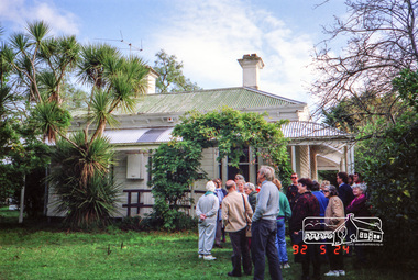
Photograph, Edendale Farm, Eltham Heritage Tour, 24 May 1992, 24/05/1992
... Mansion Gates - A Surviving Farm House - An Intact Circa 1900 Main... - Toorak Mansion Gates - A Surviving Farm House - An Intact Circa ...ELTHAM HERITAGE TOUR The Society excursion on 24th May 1992 was arranged by David Bick, leader of the team carrying out the Shire's heritage study. David selected a number of sites or buildings identified in the study, some of them lesser known components of the Shire's heritage. The tour commenced at the Eltham Shire Office at 10.00 am. Travel was by private car and mini-bus with stops at about twelve locations for commentary by David.It included a short walk in Hurstbridge and lunch at Kinglake. Highlights of the tour included: - 10 am Leave from Shire Offices - 3 Important Trees - A Physical Link to Eltham's First Settlers - Toorak Mansion Gates - A Surviving Farm House - An Intact Circa 1900 Main Street - First Settlers - Gold Miners, and Timber-getters - An Early Hotel - A Pioneering Homestead - Changing Eltham Shire - 20th Century - 4 pm Afternoon Tea and Finish Tour Extract from ELTHAM CULTURAL HERITAGE TOUR (Newsletter No. 85, July 1992, by Bettina Woodburn) "The land was unprofitable for intensive farming, but there was always water in the Diamond Creek. The railway, a technological advance, followed the valley, and was provided to transport produce. At North Eltham we were privileged to tour a surviving farmhouse of the 1860-70 era at the Shire’s Edendale Farm, with the as yet unfinished Sculpture for a front fence - bulbous tree-trunks decorated with salt pots, with cross members from the old trestle bridge. As was usual these six veranda posted houses faced South (or East, away from the sun!) with the scullery, kitchen and pantry "out the back". The veranda, which must have been very narrow, no longer exists. It probably wrapped around three sides. The drive took us past the Dutch Windmill, only twenty years old and in the Shire of Diamond Valley, then the Diamond Creek Cemetery with impressive gateway, to a detour to see another old farmhouse, isolated on a hill off Murray Road Wattle Glen. Here was a particularly thick patch of exotic planting of pines and cypresses. Subsistence farming no longer pays. Following the rail-line we noticed on the left near Silvan Road an Edwardian cottage and on the right near Yates Road the old school residence for this Upper Diamond Creek area."Record of the Society's history and activities and highlighting various aspects of the Heritage Study undertaken by David Bick used to create the future heritage overlay for the Shire of Eltham and later Nillumbik Shire.Roll of 35mm colour negative film, 4 stripsKodak Gold 100 5095eltham, shire of eltham historical society, activities, heritage tour -
 Eltham District Historical Society Inc
Photograph, Edendale Farm, Eltham Heritage Tour, 24 May 1992, 24/05/1992
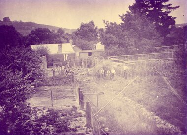
... Mansion Gates - A Surviving Farm House - An Intact Circa 1900 Main... - An Intact Circa 1900 Main Street - First Settlers - Gold Miners ...ELTHAM HERITAGE TOUR The Society excursion on 24th May 1992 was arranged by David Bick, leader of the team carrying out the Shire's heritage study. David selected a number of sites or buildings identified in the study, some of them lesser known components of the Shire's heritage. The tour commenced at the Eltham Shire Office at 10.00 am. Travel was by private car and mini-bus with stops at about twelve locations for commentary by David. It included a short walk in Hurstbridge and lunch at Kinglake. Highlights of the tour included: - 10 am Leave from Shire Offices - 3 Important Trees - A Physical Link to Eltham's First Settlers - Toorak Mansion Gates - A Surviving Farm House - An Intact Circa 1900 Main Street - First Settlers - Gold Miners, and Timber-getters - An Early Hotel - A Pioneering Homestead - Changing Eltham Shire - 20th Century - 4 pm Afternoon Tea and Finish Tour. Extract from ELTHAM CULTURAL HERITAGE TOUR (Newsletter No. 85, July 1992, by Bettina Woodburn) "The land was unprofitable for intensive farming, but there was always water in the Diamond Creek. The railway, a technological advance, followed the valley, and was provided to transport produce. At North Eltham we were privileged to tour a surviving farmhouse of the 1860-70 era at the Shire’s Edendale Farm, with the as yet unfinished Sculpture for a front fence - bulbous tree-trunks decorated with salt pots, with cross members from the old trestle bridge. As was usual these six veranda posted houses faced South (or East, away from the sun!) with the scullery, kitchen and pantry "out the back". The veranda, which must have been very narrow, no longer exists. It probably wrapped around three sides. The drive took us past the Dutch Windmill, only twenty years old and in the Shire of Diamond Valley, then the Diamond Creek Cemetery with impressive gateway, to a detour to see another old farmhouse, isolated on a hill off Murray Road Wattle Glen. Here was a particularly thick patch of exotic planting of pines and cypresses. Subsistence farming no longer pays. Following the rail-line we noticed on the left near Silvan Road an Edwardian cottage and on the right near Yates Road the old school residence for this Upper Diamond Creek area."Colour photograph1992, culture, edendale, edendale community farm, events -
 Eltham District Historical Society Inc
Photograph, Edendale Farm, Eltham Heritage Tour, 24 May 1992, 24/05/1992
... Mansion Gates - A Surviving Farm House - An Intact Circa 1900 Main... - An Intact Circa 1900 Main Street - First Settlers - Gold Miners ...ELTHAM HERITAGE TOUR The Society excursion on 24th May 1992 was arranged by David Bick, leader of the team carrying out the Shire's heritage study. David selected a number of sites or buildings identified in the study, some of them lesser known components of the Shire's heritage. The tour commenced at the Eltham Shire Office at 10.00 am. Travel was by private car and mini-bus with stops at about twelve locations for commentary by David. It included a short walk in Hurstbridge and lunch at Kinglake. Highlights of the tour included: - 10 am Leave from Shire Offices - 3 Important Trees - A Physical Link to Eltham's First Settlers - Toorak Mansion Gates - A Surviving Farm House - An Intact Circa 1900 Main Street - First Settlers - Gold Miners, and Timber-getters - An Early Hotel - A Pioneering Homestead - Changing Eltham Shire - 20th Century - 4 pm Afternoon Tea and Finish Tour. Extract from ELTHAM CULTURAL HERITAGE TOUR (Newsletter No. 85, July 1992, by Bettina Woodburn) "The land was unprofitable for intensive farming, but there was always water in the Diamond Creek. The railway, a technological advance, followed the valley, and was provided to transport produce. At North Eltham we were privileged to tour a surviving farmhouse of the 1860-70 era at the Shire’s Edendale Farm, with the as yet unfinished Sculpture for a front fence - bulbous tree-trunks decorated with salt pots, with cross members from the old trestle bridge. As was usual these six veranda posted houses faced South (or East, away from the sun!) with the scullery, kitchen and pantry "out the back". The veranda, which must have been very narrow, no longer exists. It probably wrapped around three sides. The drive took us past the Dutch Windmill, only twenty years old and in the Shire of Diamond Valley, then the Diamond Creek Cemetery with impressive gateway, to a detour to see another old farmhouse, isolated on a hill off Murray Road Wattle Glen. Here was a particularly thick patch of exotic planting of pines and cypresses. Subsistence farming no longer pays. Following the rail-line we noticed on the left near Silvan Road an Edwardian cottage and on the right near Yates Road the old school residence for this Upper Diamond Creek area."Colour photograph1992, culture, edendale, edendale community farm, events -
 The Beechworth Burke Museum
Photograph - Lantern Slide, c1900
... or official building in the Beechworth region, circa 1900. The two non... or official building in the Beechworth region, circa 1900. The two non ...This image shows six older Chinese men standing in a row with two younger non-Chinese men outside a small wooden business or official building in the Beechworth region, circa 1900. The two non-Chinese men are wearing clothes of the period that indicate relative prosperity (such as three piece suits, top hats, and a pocket handkerchief), whereas most of the Chinese men are wearing Western-style working clothes of the era. One Chinese man at the far right of the image is wearing similar garments to the non-Chinese men, including a bowler hat and longer, more tailored suit jacket. Chinese miners were a significant cultural group in Beechworth's gold rush period. Carole Woods' history of Beechworth, 'A Titan's Field', details that there were approximately 60 Chinese people in the area in 1855, more than 1000 in 1856 and 4700 (a quarter of the population) in 1857, despite the introduction in 1855 of official policies such as additional taxes formulated by the Victorian Government to limit access by Chinese immigrants. Most Chinese miners in the region came from southern China and had formerly worked as merchants, mechanics, farmers and shop-keepers. Chinese people were subjected to a 'protectorate' system, ostensibly to minimise the potential for conflict with other groups; this system required Chinese people to live in designated 'hygienic' camps with paid Chinese headmen who supervised the village and enforced the protectorate's rules. Chinese people were required to purchase an annual protection ticket to fund this system. The protectorate system was abolished in 1861, before this image was taken in approximately 1900, but it may still provide insight into social stratification or relationships between and within cultural groups in Beechworth resulting from such practices. Lantern slides, sometimes called 'magic lantern' slides, are glass plates on which an image has been secured for the purpose of projection. Glass slides were etched or hand-painted for this purpose from the Eighteenth Century but the process became more popular and accessible to the public with the development of photographic-emulsion slides used with a 'Magic Lantern' device in the mid-Nineteenth Century. Photographic lantern slides comprise a double-negative emulsion layer (forming a positive image) between thin glass plates that are bound together. A number of processes existed to form and bind the emulsion layer to the base plate, including the albumen, wet plate collodion, gelatine dry plate and Woodburytype techniques. Lantern slides and magic lantern technologies are seen as foundational precursors to the development of modern photography and film-making techniques.This glass slide is significant because it provides insight into Beechworth's cultural and social relationships in the early Twentieth Century, in particular the experiences of Chinese miners. It is also an example of an early photographic and film-making technology in use in regional Victoria in the time period.Thin translucent sheet of glass with a circular image printed on the front and framed in a black backing. It is held together by metals strips to secure the edges of the slide.burke museum, beechworth, lantern slide, slide, glass slide, plate, burke museum collection, photograph, monochrome, magic lantern, indigo shire, north-east victoria, nineteenth century, 1900s, twentieth century, emulsion slides, chinese, chinese miners, protectorate system, protection licence, immigration, racism, classism, social groups, cultural groups, taxes, hygiene camps -
 Eltham District Historical Society Inc
Photograph, Shire of Eltham War Memorial, Memorial Park, Garden Hill, Kangaroo Ground; Eltham Heritage Tour, 24 May 1992, 24/05/1992
... Mansion Gates - A Surviving Farm House - An Intact Circa 1900 Main... - Toorak Mansion Gates - A Surviving Farm House - An Intact Circa ...ELTHAM HERITAGE TOUR The Society excursion on 24th May 1992 was arranged by David Bick, leader of the team carrying out the Shire's heritage study. David selected a number of sites or buildings identified in the study, some of them lesser known components of the Shire's heritage. The tour commenced at the Eltham Shire Office at 10.00 am. Travel was by private car and mini-bus with stops at about twelve locations for commentary by David.It included a short walk in Hurstbridge and lunch at Kinglake. Highlights of the tour included: - 10 am Leave from Shire Offices - 3 Important Trees - A Physical Link to Eltham's First Settlers - Toorak Mansion Gates - A Surviving Farm House - An Intact Circa 1900 Main Street - First Settlers - Gold Miners, and Timber-getters - An Early Hotel - A Pioneering Homestead - Changing Eltham Shire - 20th Century - 4 pm Afternoon Tea and Finish Tour Extract from ELTHAM CULTURAL HERITAGE TOUR (Newsletter No. 85, July 1992, by Bettina Woodburn) "Now we drove through stands of pines to the Kangaroo Ground Lookout Tower, a most unusual War Memorial, World War I. The tower and a shed/residence (it had a chimney) were built from local sandstone. Below to the south and east of Melbourne spread 'suburbia'. Close by the landscape seemed so contrived - English fields and hedgerows! Although only about twenty inches deep, the soil of this ancient volcano, its crater lost under subsequent weathering, was rich, deserving the name of "Garden Hill". Now native trees are taking over again. In Kangaroo Ground itself stand the inevitable Store, School and Church - and two Norfolk pines and a monkey puzzle tree." On November 11th 1926 the Shire of Eltham War Memorial Tower at Kangaroo Ground was opened. It is regarded as one of Melbourne’s most outstanding lookout towers. It commands a magnificent 360 degree panorama from Kinglake across the Diamond Valley to Macedon and the You Yangs. It is built on a peak which was once a volcano, 237 metres above sea level. After World War one a memorial cairn was erected on the site, and in 1925 a committee of public-minded citizens began to plan for a tower. Many generous donations of material and money were forthcoming so that in 1926 the Governor General Lord Stonehaven was able to unveil the plaque before a crowd of 500 people. There was some concern in the 1960s when the Forests Commission wanted to build a firespotters cabin on the top. At first R.S.L. branches opposed the idea, but it was realised that this use could combine with its use as a tourist attraction, and would ensure its maintenance for the future, Today the Kangaroo Ground tower provides one of the best views around Melbourne and is a fitting memorial to those who died in two world wars. From: Historic items for Diamond Valley Community Radio September 1990 (EDHS collection) Record of the Society's history and activities and highlighting various aspects of the Heritage Study undertaken by David Bick used to create the future heritage overlay for the Shire of Eltham and later Nillumbik Shire.Roll of 35mm colour negative film, 4 stripsKodak Gold 100 5095culture, events, garden hill, kangaroo ground, kangaroo ground memorial, memorial park, shire of eltham war memorial tower, war memorials -
 Eltham District Historical Society Inc
Photograph, Monash Bridge, Arthurs Creek Road, Hurstbridge, Eltham Heritage Tour, 24 May 1992, 24/05/1992
... Mansion Gates - A Surviving Farm House - An Intact Circa 1900 Main... - Toorak Mansion Gates - A Surviving Farm House - An Intact Circa ...ELTHAM HERITAGE TOUR The Society excursion on 24th May 1992 was arranged by David Bick, leader of the team carrying out the Shire's heritage study. David selected a number of sites or buildings identified in the study, some of them lesser known components of the Shire's heritage. The tour commenced at the Eltham Shire Office at 10.00 am. Travel was by private car and mini-bus with stops at about twelve locations for commentary by David.It included a short walk in Hurstbridge and lunch at Kinglake. Highlights of the tour included: - 10 am Leave from Shire Offices - 3 Important Trees - A Physical Link to Eltham's First Settlers - Toorak Mansion Gates - A Surviving Farm House - An Intact Circa 1900 Main Street - First Settlers - Gold Miners, and Timber-getters - An Early Hotel - A Pioneering Homestead - Changing Eltham Shire - 20th Century - 4 pm Afternoon Tea and Finish Tour Extract from ELTHAM CULTURAL HERITAGE TOUR (Newsletter No. 85, July 1992, by Bettina Woodburn) "On the Arthurs Creek Road is a bridge designed by Monash, which we admired before walking across the little park with a mud-brick and timber shelter, to the Hurst family graveyard. There are two marked graves, one, Henry who was shot by Burke the bushranger and a cairn has a plaque listing others buried here from 1866 onwards. Burke was captured and tied to the wheel of a dray under the eucalypt near the waterhose/standpipe. Close by the kindergarten, at this place are three trees on the National Trust Register, a Canary Island pine, a Canadian cedar and probably a spruce. Radiata pines and a thick bolled peppercorn surround the little cemetery. Continuing along Main Street we notice elm trees planted as a war memorial, then on the left a 1930 timber house, a 1910 store and residence, resplendent with wrought iron trim, a double fronted Hardware Store and cypresses on the back alignment of a new vacant block. On the right side of the street is a less interesting attempt at an 'in character' shop. Further on are more early homes, one tucked away at the rear with two tall palms by the front steps. Another curiosity is a rounded veranda corner and there are more galvanised iron sheds or garages, before a mud-brick Dentist's Surgery. Beyond the round-a-about is St Peters Church, of mud-brick construction shared by Catholic and Anglican parishioners, overlooking the river flood plain. Leaving Hurstbridge on the Kinglake Road, we ate our picnic lunch beside the communication tower and enjoyed views of Melbourne, Yan Yean Reservoir and the distant Dandenongs beyond the spreading suburbs. Next we drove to the North West boundary of the Shire at Masons Falls Road towards Whittlesea. On the way to the North East Boundary we passed St Peters, a yellow wooden Church with a Tudor Archway; built in the early 1920's in the style of the 1860's. From the Healesville-Kinglake road the rolling hills had European aspects, the hedged fields and chestnut trees. Then it was back down the Hurstbridge Road through 'Aussie' bush of towering gums, with bracken and scrubby understorey, the Kinglake National Park, before more open country with deciduous trees planted in line, and a creek lined with willows."Record of the Society's history and activities and highlighting various aspects of the Heritage Study undertaken by David Bick used to create the future heritage overlay for the Shire of Eltham and later Nillumbik Shire.Roll of 35mm colour negative film, 4 stripsKodak Gold 100 5095shire of eltham historical society, activities, heritage tour, hurstbridge, monash bridge, arthurs creek road -
 Eltham District Historical Society Inc
Photograph, Woodburn residence, mudbrick adobe (1949), Eltham Heritage Tour, 24 May 1992, 24/05/1992
... Mansion Gates - A Surviving Farm House - An Intact Circa 1900 Main... - Toorak Mansion Gates - A Surviving Farm House - An Intact Circa ...ELTHAM HERITAGE TOUR The Society excursion on 24th May 1992 was arranged by David Bick, leader of the team carrying out the Shire's heritage study. David selected a number of sites or buildings identified in the study, some of them lesser known components of the Shire's heritage. The tour commenced at the Eltham Shire Office at 10.00 am. Travel was by private car and mini-bus with stops at about twelve locations for commentary by David.It included a short walk in Hurstbridge and lunch at Kinglake. Highlights of the tour included: - 10 am Leave from Shire Offices - 3 Important Trees - A Physical Link to Eltham's First Settlers - Toorak Mansion Gates - A Surviving Farm House - An Intact Circa 1900 Main Street - First Settlers - Gold Miners, and Timber-getters - An Early Hotel - A Pioneering Homestead - Changing Eltham Shire - 20th Century - 4 pm Afternoon Tea and Finish Tour Extract from ELTHAM CULTURAL HERITAGE TOUR (Newsletter No. 85, July 1992, by Bettina Woodburn) "In some respects Eltham is a 'back-water' and it has its own distinctive flavour. On the outskirts the homes date from the 1960's, 70's and 80s with a sprinkling of 'earth homes', mud-brick or pise, rammed dirt. Crossing Main Road into Beddoe Street and Thompson Crescent a very pleasant drive past pines and old fence lines, front lawns unfenced, the occasional ·old farm building, we eventually looked down on a huge circular roof of a 1992 adobe home. Other distinctive places included the Pauline Toner Butterfly Reserve, Gordon Ford's splendid garden at Fulling in Pitt Street, cypress hedges and old houses in Bridge Street and in every direction Eltham's special feature - a totally treed horizon. We were now in the part of the Shire closest to Melbourne - Montmorency - not on the way to anywhere, with no through road going across it, developed in the 1950's and 1960's with conventional gardens, now converted to native plants. The rail looped between Greensborough and Eltham and a shopping street (Were Street) served the area, growing up the hill from the station. It was a typical outer Melbourne suburb with lawns and roses with patches of originality. The shopping precinct still has 1950 characteristics - walls which sloped back, projecting roofs, the original shop fronts are nearly all tiled below the old windows. There's an air of past times about the School, the Dairy, the Butcher's (now a milk bar) and the Castlemaine stone face of the Commonwealth Bank. The final stop for the tour was at the mud-brick Woodburn residence, adobe of 1949 with additions. After War Service, Bill Woodburn had commenced an Architecture course at Melbourne University and after second year in the Christmas vacation, with his wife, Betti, built the two bedroom house - with amazing saving of costs. In the three and a half months they made over 3000 bricks (external walls 18" x 12" x 4", internal walls 12" x 9" x 4"), sifted top soil for mortar and laid them, on concrete foundations and slab floor, made all the structural window frames, door frames and roof members to carry 'super six' asbestos sheets, laboured for the electrician and plumber, did all the glazing and, still without electricity, moved in in March 1949. Rooms have been added, at first with glass walls, later using concrete blocks, to accommodate three daughters and a son. The house not only grew from the earth, but also with the family."Record of the Society's history and activities and highlighting various aspects of the Heritage Study undertaken by David Bick used to create the future heritage overlay for the Shire of Eltham and later Nillumbik Shire.Roll of 35mm colour negative film, 4 stripsKodak Gold 100 5095shire of eltham historical society, activities, heritage tour, woodburn house -
 Eltham District Historical Society Inc
Photograph - Digital Photograph, Alan King, Kangaroo Ground General Store, Eltham-Yarra Glen Road, 28 December 2007
... The present store was built circa 1900 to replace another...The present store was built circa 1900 to replace another ...The present store was built circa 1900 to replace another which had been destroyed by fire in 1898, which had replaced a predecessor on the opposite side of the road in 1865. The store was also used as a post office until early 2000s. The general store is historically significant because it has a long association with Kangaroo Ground and has been an important centre of community life for more than 120 years - Council meetings used to be conducted in the front room of the store at a time when Kangaroo Ground rivalled Eltham as the major centre of the Shire. The general store is historically and aesthetically significant as one of a group of three well preserved public buildings in the Kangaroo Ground hamlet and as a major heritage component of Kangaroo Ground which was one of the earliest settled areas of the Shire and which has the character of an English village rather than an Australian settlement. Covered under Heritage Overlay, Nillumbik Planning Scheme. Published: Nillumbik Now and Then / Marguerite Marshall 2008; photographs Alan King with Marguerite Marshall.; p77 Today the general store is an uncommon form of trade but the one at Kangaroo Ground continues a long tradition of friendliness and service. For more than 100 years it has been a centre of community life. In the settlement’s early days a previous general store, on the same site, was the meeting place for the Eltham District Road Board, precursor to the Eltham Shire Council. For years Kangaroo Ground rivalled Eltham as the shire’s major centre. It developed very differently from the rest of the shire as its rich soil attracted prosperous Presbyterian Scots who had large agricultural properties.1 The present store was built to replace another one, which had burnt down in 1898, after replacing a predecessor on the other side of the road in 1865. The store retains its outward character and its cellar, although inside it has changed considerably. It now includes a café and offers local produce, milk bar products, grocery items, gas and other fuel. Until early this century the store was also used as a post office. Kangaroo Ground’s first postmaster was Andrew Ross, who first operated from the school opposite, then from his hotel next to the present tennis court site. The first postmaster at this store was Edward Weller, followed in 1868 by James Anderson. At that time a mail coach ran three times a week between Eltham and Woods Point through Kangaroo Ground, Yarra Flats, Healesville, Fernshaw, Marysville and Matlock. Some early postmasters were Rodger, McLaughlin, Greenway and Burns.2 Burns was the only postmaster operating from the store. The others operated from Andrew Ross’s hotel. The mail service improved in 1892 when coaches ran from Melbourne to Queenstown (now known as St Andrews) and changed horses at Kangaroo Ground twice daily. The only telegraph office in the district at that time was at the Kangaroo Ground Post Office. Telegrams to outlying areas such as Queenstown and Kinglake had to be sent by hand. A local resident in the early 1900s often rode his pony to deliver telegrams and was paid one shilling a mile porterage. The store has also contributed to the lighter side of Kangaroo Ground life. During the years that Con Wraight owned the store, between 1906 and 1946, a new piano was needed for the Kangaroo Ground Hall, so monthly dances were held to raise money. When the piano was bought, a grand ball was held in the Kangaroo Ground Hall to celebrate the occasion and supper followed at Mr Wraight’s barn, cleaned especially for the occasion. Every New Year’s Eve, a Scottish piper would set off from between the store and the schoolhouse, playing his pipes, and march to Cameron’s Pigeon Bank homestead on the Kangaroo Ground-Warrandyte Road. Between 1914 and 1922, the store was a station for the Kangaroo Ground Bush Fire Brigade’s tanker. It consisted of a wooden barrel on a cart, fitted with a hand-pump, and stood on the side of the road outside the store. Joy Ness, who belonged to an early Kangaroo Ground family, moved here in 1940 and recalled her impressions of the store at that time: ‘It was a very dark shop stained in a dark colour and on the walls just below the ceiling hung hurricane lamps, ropes, kitchen utensils and other goods for sale. ‘Goods were weighed on a brass scale with weights, on which mothers also weighed their babies, because the nearest Infant Welfare Centre was at Greensborough. The bacon was cut with a hand slicer and later a pot-bellied stove warmed the store. Farmers and other locals used to gossip around it as they collected their daily mail. In those days the butter and cheese were kept in the cellar as no ice was delivered for cooling.’This collection of almost 130 photos about places and people within the Shire of Nillumbik, an urban and rural municipality in Melbourne's north, contributes to an understanding of the history of the Shire. Published in 2008 immediately prior to the Black Saturday bushfires of February 7, 2009, it documents sites that were impacted, and in some cases destroyed by the fires. It includes photographs taken especially for the publication, creating a unique time capsule representing the Shire in the early 21st century. It remains the most recent comprehenesive publication devoted to the Shire's history connecting local residents to the past. nillumbik now and then (marshall-king) collection, eltham-yarra glen road, kangaroo ground general store -
 Kiewa Valley Historical Society
Photo - School Children Tawonga Primary School, Circa 1920 (estimate)
Tawonga is in the Kiewa Valley, where local farmers lived with their families. The school was originally opened July 27 1880, situated on 8 acres near the current township of Tawonga. The school was erased by fire in 1900 and all records destroyed. The school was then moved to the Old Tawonga Hall. In 1910, the school was shifted to its present site on 3 acres of land donated by Frank Cooper. The school building and attendance continued to grow, especially during construction of the Kiewa Hydro Electric Scheme.Tawonga Primary School has educated the local farming and town children for many years. It is an excellent source of the names of the local families of the time. Copy of black and white photograph of pupils at Tawonga Primary School. Circa 1920 (estimate)tawonga primary school, kiewa valley -
 Eltham District Historical Society Inc
Photograph, A.W. Burman, Possibly Catherine Shillinglaw, c.1878
Catherine Shillinglaw was born November 13, 1852 at Coburg, Victoria. In 1897 she married Edward Henry Bottle (1854-1900). Catherine died April 7, 1934 at Northcote, Victoria. A.W. Burman, Artist Photographer, 209 Bourke Street East, Melbourne According to Sands & McDougall Melbourne Directory, Arthur W. Burman was active 209 Bourke St East, Melbourne from 1878 to circa 1885-1890 CARTE-DE-VISITE (cdv) 1857-1890 Cartes-de-visite (cdv's) are the most common form of photograph from the nineteenth century, generally measuring two and a half inches by four and an eighth inches (6.3 x 10.5 cm) when mounted, sepia toned, mounted on a card which was generally printed with the photographer's name and address on the back or beneath the portrait. - Frost, Lenore; Dating Family Photos 1850-1920; Valiant Press Pty. Ltd., Berwick, Victoria 1991a.w. burman photographer 209 bourke st east, marg ball collection, shillinglaw family photo album 1, 1878, 1878-1885, catherine bottle (nee shillinglaw 1852-1934), unknown -
 Lorne Historical Society
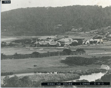
Photograph - Photograph Erskine House Lorne Circa 1910, Erskine House and Lorne circa 1910
View of Erskine House and Lorne Circ 1900lorne, erskine house -
 Kiewa Valley Historical Society
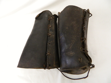
Gaiters Riding, Late 19th Century
These gaiters where used circa 1800's to mid 1900's, by horse riders "cattle men" to protect their shins and long trousers against wear and tear. They were used rather than having expensive boots damaged. Gaiters were a lot easier to fasten and clean than boots. They were used in the Kiewa Valley and the High Plains grazing areas.These gaiters were part of a cattleman's "out fit". The Gaiters were easily cleaned and did away with expensive riding boots. They were used throughout the valley and high plains areas both by horse riders herding cattle and the recreational rider of both sexes. After the 1950s more recreational riders from Melbourne ventured onto the high plains and not so rugged mountain slopes. Small settlements such as Mount Beauty, Bogong village and Falls Creek provided a secure backdrop for short term horse back adventures. The increasing pressure of city life provided a greater flow of stressed out city dweller to find the peace and quiet that city life does not have. Horse riding preceded the modern trail bikes and other recreational vehicles of the late 1900s. Thick leather tapered gaiters with six metal Hooks and Leather lacing through metal eyelets. All bar two eyelets have a metal reinforced punch holes. Left gaiter missing most of lacing.horse, country, leather, gaiters, high, grazing, cattlemen, laces, studs -
 Kiewa Valley Historical Society
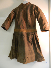
Dress
... to the period circa 1900 to circa 1950 when fashion was dictated by long ...made locally circa 1910. Due to relative long distance to haberdashery stores majority of children's garments were hand made by a local talented seamstress or mother/relativeHistorical significant to the period circa 1900 to circa 1950 when fashion was dictated by long lasting durability, local manufacture, earthy colours and ease of mobility. Photos in the KVHS collection show girls from Tawonga Primary School in a dress that could be this dress which is dated 1910. Dress brown cotton with long sleeves. Dress top and sleeves lined. Back of dress is open with metal hooks for fastening. Hand stitched eyelets and decorative strip down centre front bodice and around hips. Gathered skirt is joined at hip. One pocket on left side 6cm from waist band.Decorative strip at bottom of dress with a pleated hand and machine stitched frill.no inscriptions or markings suggesting locally made.dress, clothing, girl's dress, home made -
 Kiewa Valley Historical Society
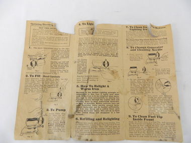
Document Instruction and Parts Sheet, Instructions for Operating the Coleman Self Heating Iron Model No. 4 Instant Lighting, circa 1950
This operating and parts information sheet was supplied to consumers to help users of this kerosene iron, not only understand the operation of this self lighting iron, but also to be able to order any replacement parts that may be required for this high level usage appliance. At this period in time(1950's), this item was at the leading edge of ironing technology. During the earlier 1900's and before "the throw away" culture evolved(circa 1950's), reliability and long term application of domestic appliances was a necessity above all costs, especially in isolated rural areas. The construction of these appliances was geared to a longer service life and not to a cheaper two to three year life warranty. With levels of world wide technology at an ever increasing pace, long term reliability of any appliance was no longer sought after. Appliance upgrades and new improved model accessibility especially in rural areas has changed rural consumer's buying patterns. Although the concept of instructional and parts/warranty information booklets has not become obsolete, the ability to access information via electronic means has vastly improved the ability to obtain qualified technical help through local avenues. This access was not available in the time period(circa 1950), when the appliance covered by this document was issued. The rate of development within the home appliance field has mushroomed during the time period post 1950. The costs and the increased levels of product choices and consumer awareness has provided rural areas (once isolated e.g. Kiewa Valley) with a greater ability to satisfy their needs because of a greater diverse range of domestic appliances offered.This discoloured, sepia paper has black print and is folded into three equal pages. The information contained covers operational and part numbers for the kerosene fired hand held iron. there are kerosene stains on the last page and these have soaked through onto the second page. The form no.-3-3C- McACO.-4363Printed in U.S.A.instructions, household appliances, ironing, domestic ironing -
 Ringwood and District Historical Society
Photograph, Willsmore family house on Whitehourse Road, Ringwood - circa 1900s
Sepia photograph"Written on back of photograph" Picture taken early 1900's standing in the present car park at rear of Bank, looking North. Mr Willsmore and three sons in back garden. The Willsmores were Wales Ringwood first customers and still have connections with us. The front of the house is in the same position as present Westpac premises. The line of trees in front of house is now Maroondah Highway. Paul E.Smith - April 1985. -
 Flagstaff Hill Maritime Museum and Village
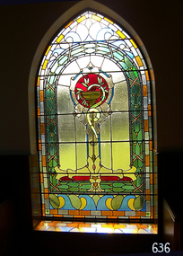
Artwork, other - Window, circa 1928
This religiously themed window is situated in the western (weather) wall of the St. Nicholas Mission to Seamen’s Church building in the Flagstaff Hill Maritime Village. It was crafted circa 1928. ABOUT THE WINDOW This window, once known as the Dr Connell Memorial Window, was a feature of an external wall adjacent to the Women’s Children’s Wards of Warrnambool Hospital. Honorary Doctors had played a significant role in the operation of the hospital between the years 1900 to 1939. One of these doctors was Dr. Connell, who passed away in 1928. The green glass plaque is also a registered object in Flagstaff Hill's Collection. Its inscription dedicates the window to Dr. Connell. The inscription reads: “A tribute to Egbert John Connell M.B.B.S. who for 30 years rendered devoted and valuable service to this institution. Obiit April 4th 1928 A.D." A paragraph in the book ‘A History of the Warrnambool Base Hospital’ by Forth and Yule describes the role of the Honorary Doctors - “At the start of the period the senior-part time medical officer was replaced by the junior resident medical officer and control of beds and the right to operate were given to the honorary medical officers...and these men dominated the Warrnambool medical world in the years before the Second World War.” Dr. Connell leased ‘Ambleside’, 192 Koroit Street, in the early 20th century, following Dr Teed who had previously run his medical practice there. In 1914 Dr Connell purchased the property and continued his private practice there until his death in 1928. He also took a prominent part in hospital work, both as physician and surgeon, and often acted as spokesmen for the Honorary Doctors. According to colleague Dr. Horace Holmes’ subsequent notes, it was after the close of the First World War, and the following years of the world-wide pneumonic influenza epidemic, that Dr. Connell himself contracted pneumonia and died. His family and friends then recognised his work by gifting the memorial window in his honour to the Hospital. By the mid-1970s the old wards at the hospital had been replaced and there was no obvious place for the window. Discussions between the previous and past Hospital managers, the Anglican Diocese, and Flagstaff Hill Planning Board, led to its installation in its present position in St Nicholas Seamen’s Church and the memorial plaque was later installed beside the window. St NICHOLAS SEAMEN’S CHURCH, Anglican Church Flagstaff Hill’s Mission to Seamen was opened in 1981. Its conception was partly motivated by the offer of Stained Glass Memorial Windows from the local Warrnambool and District Base Hospital, which was undergoing multi-storey development in the late 1960’s and early 1970’s. The Manager/Secretary at the time was keen to see the historical windows installed in an appropriate location. The chapel was designed by a local architectural draftsman in conjunction with members of the Planning Board of Flagstaff Hill, and built by Mr Leon Habel. The vision of the designers included the hope that the church be used for formal worship such as weddings and funeral, and for multi-denominational special services such as War commemorations. The design is based on the ‘Mission to Seamen’ buildings in both Portland and Port Melbourne. These types of buildings were often erected to house social and worshipful activities for seamen. The materials used in the building include sandstone recycled from nineteenth-century buildings demolished in Warrnambool and American slate tiles retrieved from the 1908 wreck of the FALLS OF HALLADALE. Most of the chapel furnishings came from the Williamstown Missions to Seamen, which was consecrated in 1946 but later decommissioned. These artefacts range from the altar cloth to the hymn board and include a visually stunning round stained glass widow called ‘Christ Guiding the Helmsman’. However the provenance of this particular artefact, large western window, is local. This stained glass memorial window is of local, historical and social significance, linking local history and heritage with one of Warrnambool's doctors, Dr. Egbert John Connell (d. 1928), who gave 30 years of dedicated, medical service to the local citizens.Stained glass leadlight window in Gothic arched metal frame with six horizontal reinforcing rods. Image depicts a golden flat-bowled baptismal font on a slender stand with foliage proceeding from it. The image is internally framed by a Roman arch of coloured glass and surrounding rectangular and breaking-wave shapes. (The window was previously known locally as the Dr. Connell Memorial Window and a plaque dedicated to Dr. Connell is catalogued separately. See Context notes for details.)flagstaff hill, warrnambool, shipwrecked coast, flagstaff hill maritime museum, maritime museum, shipwreck coast, flagstaff hill maritime village, great ocean road, chapel window, stained glass window, warrnambool and district base hospital, st nicholas mission to seamen’s church, williamstown mission to seamen, dr egbert connell, ambleside warrnambool, leon habel builder, falls of halladale slate, memorial window, commemorative window, dr connell