Showing 735 items
matching city hotel
-
 Ballarat Tramway Museum
Photograph - Black & White Photograph/s, Nov. 1965
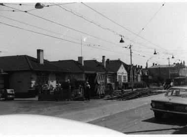
Set of seven Black and white photographs on Kodak paper for the arrangements and work for the track reconstruction of Commercial Road Prahran. Series of photos show Down track already complete. Probably second half of October or early November 1965. (Electric Traction 11/65) (Unusual to have two jobs at once - see Hawthorn Rd - Reg item 1421). Series show the construction method. Temporary track formed by progressively lifting original track on to side of road each night. Relaying then follows progressively. Pictures show almost completed section (1423.1 &2), concreting (1423.3), new rails in situ (1423.4&5),newly moved track (1423.6&7), excavation taking place (1423.7) 1421.1 - Commercial Rd looking west at Charles St showing ramp to temporary city bound track. 1423.2 Ditto - just west of Charles St. 1423.3 Ditto - corner Perth St on left, Hyland St on right. 1423.4 Ditto - between Perth and Donald Sts. Scrubber car No 9. 1423.5 Ditto - looking east between Perth and Donald Sts. - W5 723 on new track, W5 722 on temporary track. 1423.6 Ditto - looking east. Max Hotel on corner of Donald St. 1423.7 Ditto - looking east at corner of Alfred St. Scrubber car No 9. See P.Winspur note with item 1418.trams, tramways, commercial road, reconstruction, trackwork, mmtb, tram 9, tram 723, tram 722 -
 Ballarat Tramway Museum
Negative, Geoff Grant, 16/06/1955 12:00:00 AM
... by Geoff Grant. Has the Melbourne Hotel, the Salvation Army City... Hotel, the Salvation Army City Temple and the J & J Building ...Negatives No. N301 and colour print made by colour laser printer (stored in folder ) of a Bourke St Bus stopped at Exhibition St. stop, looking east along Bourke on 16/6/1955. Photo by Geoff Grant. Has the Melbourne Hotel, the Salvation Army City Temple and the J & J Building (Mickey Powell Dancing). Parliament House in the background. Negative scanned hi res and imaged updated 20/5/2020.trams, tramways, melbourne, bourke st., buses, exhibition st. -
 Ballarat Tramway Museum
Slide - 35mm slide/s, Travis Jeffrey, late 1960's
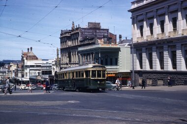
Agfa plastic mount (blue base, white cover) of a photograph of No. 30 turning from Lydiard St. North into Sturt St. Has the National Mutual building, Craigs Hotel and MLC building in the background. Note tram stop on the pole adjacent to the Post Office and the policemen standing on the corner near the City terminus. Slide rescanned at 3200 dpi 25-10-2020, jpg replaced, tiff file retained. This file was scanned in 2003 and may show colour changes."BAS 45" in penciltramways, trams, sturt st, lydiard st nth, tram 30 -
 Ballarat Tramway Museum
Negative - Black and white print from negative, Travis Jeffrey, 12/12/1958?
Negative No. N375 and black and white print made by a laser printer (stored in folder) of Ballarat No. 12 in City or Grenville St Loop with Grenville St and Bridge St. in the background. Date thought to be 12/12/1958. Tram has destination of City. Can see the Bucks Head Hotel in the background and the full length of Bridge St., with Victoria St. hill as well. W. Gribble & Co. building on the right hand side of the photograph. Although folder dated 23/2/62, the photo is taken before 12/1960, as tram has not been fitted with dash canopy lights, so date taken as for photograph BA1, Reg. No. 2381 - note angle of shadow. hi res scan made and image updated 23/5/2020. Paper folder that contained the negative had "NR64A" in red ink, "BA2" in pencil, date stamp of "23 Sep 62" on front, and on rear date stamps "26 Sep 1962" and "6 Oct 1962".trams, tramways, city loop, grenville st, bridge st, sturt st, tram 12 -
 Ballarat Tramway Museum
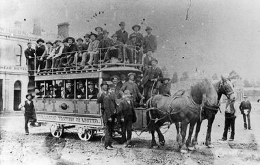
Photograph - Black & White Photograph/s, 1887/8
Yields information about the early use of the Ballarat horse trams and condition of the roadway - lots of rocks on the road surface. Also shows an all male loading of passengers.Black and White copy photograph of a State Library of South Australia SLSA B34585 of an well loaded, only male passengers on a Ballaarat Horse Tram - Grenville and Sturt St. Two horse with many men, Wilson's Bucks Head Hotel in background. Condition of the road surface very rough - can't see the rails. Photo taken in early days, as no modesty boards on upper deck - say 1887. Possibly a trial trip. Collected by Alan Bradley from the State Library of South Australia early 1980's. Used in The Golden City and its Tramways - page 28.tramways, trams, sturt st, grenville st, bucks head hotel, horse tram -
 Ballarat Tramway Museum
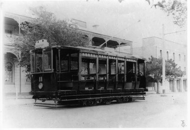
Photograph - Bromide of a b/w photograph and Black & White Photograph/s, 1890's
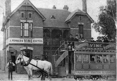
Black and White scan or Bromide copy of a photograph of Ballaarat Tramway Company horse tram No. 5 outside the Vine Hotel in Macarthur St, Ballarat on the corner with Creswick Road. Has A. Ronald's Vine Hotel in the background with a Vine Hotel advertisement on the modesty board of the tramcar. Has a number of passengers, including ladies on the top deck and around the tramcar and hotel. Original of photograph from Harris House of Photography. Collected by Alan Bradley from the State Library of South Australia early 1980's. Used in The Golden City and its Tramways - page 29. 3792.1 - black and white photograph print of above - added 29/7/2007, ex Alan Bradley collection of photographs 5/2007.tramways, trams, horse trams, vine hotel, macarthur st, advertisements, tram 5 -
 Ballarat Tramway Museum
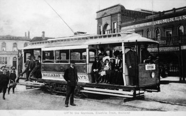
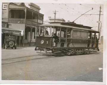
Photograph - Black & White Photograph/s, 1905
Yields information about the opening configuration and early passengers of the tramways in Ballarat, with the Sturt and St Grenville St buildings behind. Shows uniforms and clothing styles.Black and White copy photograph of a Ballarat Municipal library (No. 911) postcard at the time of the opening of the Electric tramway in Ballarat. Tram has destination of Gardens, with four crew/inspector in uniforms, a number of well dressed passengers including ladies and children and some boys at the rear. Shows arrangements of steps lining etc. In the background is the Bucks Head Hotel, a Confectioner (J.M. Kiln?) and other buildings. Photo taken in 1905. Collected by Alan Bradley from the Ballarat Municipal library early 1980's. Used in The Golden City and its Tramways - front covertramways, trams, sturt st, electrification, grenville st, opening -
 Ballarat Tramway Museum
Photograph - Colour Print/s - set of 4, Sep. 1972
Has a strong association with Elvie Phillips - at the time of the closure of the SEC system in Ballarat.Set of four colour prints - were contain within a folder (see below) of Elvie Phillips and crews at the time of the closure of the Ballarat SEC system - September 1971. .1 - standing on the step of a bogie tram with crew member number 58 behind. .2 - City loop with two crew members on either side - and three bogie trams .3 - standing in front of a single trucker, City Loop - with the Union Hotel behind. .4 - sitting on the bumper of a single trucker, Wendouree Parade, Gardens area with a crew member alongside. Printed on Kodak paper. Note - these type of photographs were common at the end of the SEC system - many people had these taken. Always in the way of the tram enthusiasts! Were held in a Wizard - Kodak Express folder - in the worksheet file along with letter and donor form.closure, sturt st, city loop -
 Ballarat Tramway Museum
Film - Movie Film & Box, Kodak, 1960
Yields information in movie film format of Ballarat trams in 1960, how the system operated and was used by people., Yields information in movie film format of Ballarat trams in 1960, how the system operated and was used by people.Movie film - 8mm, approx. 30mins, with leader strip on a plastic reel, within a black and white plastic box, titled "Ballarat No. 1. 1960". Has been transferred to DVD - see Reg item 4100 as Segment No. 2. Made by Ben Parle. Also transferred to DVD by Rod Cook Oct. 2015, via Roger Greenwood for use in his DVD, "The City of Ballarat Trams, Gardens & Gold" of 2016. See Reg Item 6883. Synopsis: based on time. 0:00 View of typed introduction, noting that this is a pictorial record of Ballarat. 0:10 Title “The Tramways of Ballarat 1960, Part 1” 0:16 13, showing “View Point” at Stones Corner, Bridge St, east end, with trolley pole being turned, while another single trucker heads out towards Mt Pleasant. 0:25 13 leaving Stones Corner, short approach and then longer trailing shot of the tram going towards the City in Bridge St. 0:44 View out of front of tram in Bridge St heading towards the City, with cars in the photo, then passing through city Loop, no trams in the loop and running up to Lydiard St Nth and crossing the road. 1:22 Running up Sturt St from Armstrong St, passes over Dawson St X-over and up to the next intersection, Lyons St. 1:54 Title “The View Point Line” 1:59 19 inbound, in Ripon St, from crossing Mair St, towards camera and then passing away and turning into Sturt St. 2:49 View of a “Warning Oncoming Trams” sign 2:52 19 in Ripon St, going to View Point, crossing Webster St towards camera, then going away through the disconnected Victoria Ave loop, pass the “Warning Oncoming Trams” sign. Note very windy scene with people running across roads. 3:17 19 in Wendouree Parade, in bound, though showing destination View Point, going away from the camera, past the View Point Hotel. 3:39 19 coming towards camera near Excerpt or Devon St and then going away towards the terminus. 4:04 19 at the terminus, stationary, with a single trucker 3?, passing from Macarthur St into Wendouree Parade, behind 19. 4:20 33 coming towards camera in Wendouree Parade from St Aidans Drive, stopping to pick up passenger at Forest St and then going away towards the City, photographed from near the depot, on a wet and windy day. 4:54 35 in Wendouree Parade, coming towards the Camera from St Aidans Drive and then going away with the Gardens Loop area in the background. Tram stops at stop to let a passenger off. 5:28 21 leaving Gardens Loop for the City via the Depot, green light in signal can be seen. 5:43 28?, closely followed by 26 turn from Drummond St South into Sturt St. 6:18 Scene opens with shot of “Sebastopol” destination on a bogie tram. 6:21 Title “The Sebastopol Line” 6:24 21 turning from Sturt St into Drummond St Sth with destination of Bell St and then going away from the camera. 6:55 38 in Drummond St Sth, coming towards the camera and then passing the camera with Sturt St just in the view. 7:10 21, showing Gregory St, in Drummond St Sth, approaching and then going away, entering the Urquhart St Loop, 7:39 34 in Drummond St Sth (location check required (Latrobe?)), approaches camera, picks up passengers and the goes away. 8:09 39 at ? Street, turns from Drummond St Sth into Skipton St, after picking up and setting down passengers, bound for Sebastopol 8:55 35 inbound in Skipton St passes through the Bell Street Loop, and then goes away from the camera. 9:33 42 outbound in Skipton St, approaches the camera, passes and then crosses over the half the road into Albert St. 10:00 39 inbound in Albert St – location? 10:31 34 outbound for Sebastopol, approaches camera and just starts to pass by. 10:36 34 in Grey St crossing loop, crosses 42 inbound. 10:59 39 outbound in Albert St, with shopping centre in bound, approaches camera, passes and then crosses over Albert St. Mid morning scene. 11:39 39 inbound, Albert St south, approaches camera and then passes and the crosses over Albert St. 12:16 41 outbound in Albert St passes the camera, and pulls into the terminus with the conductor getting out on the back bumper to pull the pole down as the tram stops and a passenger walks into the Royal Hotel. 12:39 Title “The Lydiard Street North Line” 12:44 Filmed from the Hotel balcony, 21 inbound in Lydiard St Nth passes over Mair St, stops while 33 passes in the other direction. 13:18 With the red light showing on the Seymour St loop signal, 33 inbound for Sebastopol stops and picks up many passengers, passes the camera and runs past the VRI building in the background and through the loop. Possibly filmed on a Sunday given the ladies dresses and quieter streets. 14:01 30 outbound, passes the camera and stops at Macarthur St. Filmed alongside the brick wall of the cutting. 14:28 30 inbound arrives, passes through the Gregory St loop and then proceeds past the camera, making a stop to pick up passengers. 15:14 28 in Lydiard St Nth – location?, approaches and goes away from the camera, north of Gregory St. 15:34 28 ditto location? 15:53 21 arrives at the terminus with passengers getting on and off. 16:11 View of the a vertical positioned “End of Section” sign on a pole at the terminus and then lifting the camera to see the timetable board and the stop sign. 16:33 31 in Bridge St passing Morseheads and then turning into Sturt St, stops at the Grenville St stop, while another single trucker comes down to the stop from the City. 16:58 31 outbound in Bridge St, with destination of Victoria St. 17:14 Title “The Victoria Street Line” 17:18 31 outbound to Victoria St from Stones Corner. Starts with an overhead shot, shows clock at the Caltex service station,. 17:37 31 inbound approaching Bakery Hill and then descending to the junction after it passes camera. 18:09 25 climbing outbound in Victoria St, passing the camera, to then pass through the King St loop. 18:47 25 inbound in Victoria St, passing the camera, then pass through the King St loop, with St Alypius Church in the background. 19:36 14 approaching the rail bridge in Victoria St and stopping at the 2nd last stop to left of passengers. 20:01 14 leaving the terminus and approaching the camera and the a short sequence going away, to the next stop to pick up quite a few passengers. 20:14 “Trams Stop Here” sign, metal wrap around on a steel pole. 20:16 Title “The Mount Pleasant Line” 20:21 11 inbound in Main St, with a passenger leaping off the tramcar and another getting off just before the junction. 20:45 11 passes the junction and then proceeds away from the camera in Bridge St. 21:04 30 outbound in Main St, then turns into Barkly St, a bus (Eclipse Motors) passes in Main St just before the sequence ends. 21:31 30 inbound near Steinfield St. (exact location?) 21:49 25 approaches the camera, then proceeds away and passes through the Grant St. loop. 22:29 25 inbound, windy day, between Grant and Cobden, (exact location?), with a horse drawn bread van in the view and the breadman walking behind the tram as it passes. 23:02 11 outbound in Barkly St, (exact location?) 23:37 11 inbound in Barkly St (exact location?) 23:44 Mt Pleasant terminus signage 23:50 30 approaches the terminus and then stops with the conductor alighting turning the pole, passengers getting on and off and the driver appearing at the other end. 24:32 Title “The Gardens Via Sturt St. West Line” 24:35 21 outbound in Sturt St near Raglan St, approaches and passes the Camera. 25:09 12, showing City Oval, approaches and passes the camera, outbound near Windermere St. 25:33 13 showing View Point, goes away from the camera – location? 25:44 12 comes from St. West, inbound passes the camera and then stop as the next stop next Talbot St? 26:21 Short sequence of a “Warning Oncoming Trams” sign 26:28 42 inbound in Sturt St West, just before Ripon St, view coming towards camera and then going away to cross Ripon St. 27:10 34 passes through the Parker St loop 27:25 35 or 39 inbound past the college in Sturt St West 28:04 41 outbound at the Russell St curve, passes away from the camera. 28:11 35? inbound passes away from the camera through the Victoria Park or Morrison St loop, swinging out into the roadway. 28:29 View of timetable sign at Hamilton Ave. 28:37 35 turning from Sturt St West into Hamilton Ave, can see the conductor changing over the barrier rails. 29:11 42 inbound, crosses another bogie tram (35?) at Carlton St loop then passes the camera and goes past the Olympic rings monument. 29:42 12 approaches the Carlton St gates. 30:07 12 outbound, crosses a bogie tram in the loop with both trams then leaving the loop. 30:20 Title “End of Part One” Written labels giving title information on outside of box.trams, tramways, ballarat, sebastopol, lydiard st north, victoria st, mt pleasant, sturt st west -
 Ballarat Tramway Museum
Film - Movie Film & Box, Kodak, 1960
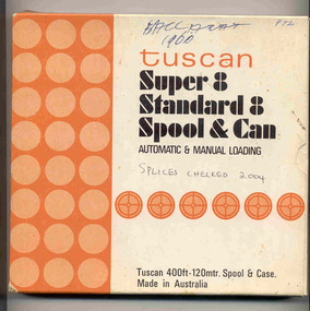
Yields information in movie film format of Ballarat trams in 1960, how the system operated and was used by people., Yields information in movie film format of Ballarat trams in 1960, how the system operated and was used by people.Movie film - 8mm, approx. 17.5 mins, with leader strip on a plastic reel, within a black and white plastic box, titled "Ballarat No. 1. 1960" contained with a cardboard box, 'Tuscan Super 8 and Standard 8 Spool and Can' . Has been transferred to DVD - see Reg item 4100 as Segment No. 1. Filmed and made by Ben Parle. Also transferred to DVD by Rod Cook Oct. 2015, via Roger Greenwood for use in his DVD, "The City of Ballarat Trams, Gardens & Gold" of 2016. See Reg Item 6883. Synopsis: based on time. 0:00 Starts with bogies cars crossing railway level crossing (34?, 39?) 0:30 SEC Logo 0:45 Ballarat Station sign and intro “Some City Scenes” 0:49 35 turning from Lydiard St Nth to Sturt St towards Grenville St with Commonwealth Bank in view. and then 42 returning 1:19 42 showing Mt Pleasant, turns from Sturt St into Lydiard St Nth 1:53 Tramway road works in Lydiard St Nth, near intersection with Mair St with Jelbart Road roller in use, starts with an SEC roadworks sign. 2:12 39 passing the works out bound to Lydiard St Nth. 2:46 Good view of the roller working before 35 arrives. 3:01 35 passing the works in bound with 3:29 14 crossing Lydiard St in Sturt St, towards Grenville St 3:47 Trams in City Loop 3:55 21 coming up the hill 4:04 31 entering Bridge St from Sturt St with Bucks Head Hotel in the background. 4:27 Overhead work at corner of Sturt and Lydiard, with view of the sign at the City terminus “Trams leave here for Sebastopol, Gardens, View Point.” 4:34 Passengers getting off and then onto 38, ex Lydiard St Nth at city terminus including a young lady wearing gloves and a wheeling a pram hurriedly the photographer. A number of other prams in the view as well as. The Conductor helps to unload the pram. 5:07 41 proceeding up Sturt St, appears to have just rained. 5:26 11 using the Dawson St crossover, with a motor car doing a U turn as well. 6:00 14 descending Sturt St towards the City, filmed at Dawson St. 6:11 Title “The Gardens via Drummond St North Line” 6:16 19 showing Victoria St, turning from Drummond St Nth into Sturt St. 6:28 30 inbound in Drummond St Nth, approach and trailing shots. Trailing shot ahs the hospital in the background. 6:49 31 outbound, Drummond St Nth, approach and trailing shots, trees are in autumn colours. 7:04 12, inbound Drummond St Nth, with Macarthur St in the background, stopping to pick up a lady, approach and trailing shots and then entering the Mill St crossing loop. 7:53 14 outbound in Drummond St Nth, dropping a lady passenger off and then turning into Macarthur St and then tram going away. 8:37 View of overhead junction at View Point Jtn. 8:45 View of “Cars Stop Here” sign and pole sign “To City Only” 8:55 30 inbound in Wendouree Parade, stops to pick up passenger, and then a trailing shot of tram entering Macarthur St loop 9:37 View of “Cars Stop Here”, “End of Section” and timetable boards at Haddon St. 9:50 34, pausing at Haddon St and then proceeding towards depot – approach and trailing shots, with “Warning Oncoming Trams” sign in shot. 10:27 “Warning Oncoming Trams” sign 10:32 34 crossing 12 at the Martin Ave loop 10:48 39? Wendouree Parade, near Barrett Ave, stopping and letting off passengers. 11:24 30 passing depot junction and then trailing shot of it entering Tram Sheds or Depot Loop and then proceeding towards the City. 12:11 Shot of the “Caution Beware of Trams” sign at the depot. 12:14 25 stopping at depot junction and then trailing shot of it going toward Forrest St. 12:47 12 passing Depot Junction, trailing shot. 13:07 Shot of :Electricity Supply Department, Ballarat Branch” sign at depot. 13:13 View of a destination showing “Depot” on a bogie tram 13:15 Title “Some Depot Scenes” 13:19 View of a trolley pole and then 13 leaving the depot through the gates, destination showing “View Point”. 13:54 View of trolley pole and then 32 stopping at the depot gates. 14:08 12 (Sunny view) running out onto Wendouree Parade and then a bogie tram approaching Depot Loop. 14:43 View of 42 running in with a single trucker behind in Wendouree Parade, and another single trucker running out. 15:02 Title “Some Scenes in the Gardens” 15:05 25 running through the Gardens, approach and trailing shots, near our Depot Junction. 15:55 View of “No Parking East of Loop” sign 15:59 View of overhead and then trackwork (with points removed), but overhead still in position at the Old Gardens Loop or Gardens South Loop and then 12 entering the loop from the south and then a trailing shot looking along the Parade. 16:33 View of “Cars Stop Here” and “End of Section” and then timetable boards at Gardens Loop. 16:55 View of 34 leaving the loop 17:14 Title “The End”Written labels giving title information on outside of box.trams, tramways, ballarat, sebastopol, lydiard st north, victoria st, mt pleasant, sturt st west -
 Ballarat Tramway Museum
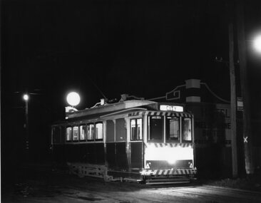
Photograph - Black & White Photograph/s, Chris Wurr, 1971
Yields information about the streetscape and the trams at night outside the Royal Mail Hotel Sebastopol, the tram terminus.Black and White photograph of a single trucker (No. 21 - five windows) at the Sebastopol terminus, Albert St, outside the Royal Mail Hotel, just prior to the changeover from trams to buses. The tram has the destination of City. The pole with the tram stop signage is behind the tram while the new? bus stop sign is on the pole adjacent to the tram. Note that the pole has been condemned by the SEC. In the background is the hotel, with Melbourne Bitter and Fosters Larger advertised on the wall.Stamped on rear in black ink "Donated to BTPS by and Photo By" / "Chris Wurr 12 Truscott Street, Ararat 3377 (053) 52 3403.tramways, trams, sebastopol, albert st, tram 21 -
 Ballarat Tramway Museum
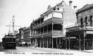
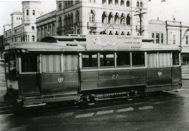
Photograph - Black & White Photograph/s and Digital Image, Valentine & Sons Publishing Co, "Lydiard Street showing George Hotel Ballarat", 1931
View of the early 1930's of No. 27 inbound in Lydiard St Nth. Valentine series No. 1492, with caption "Lydiard Street showing George Hotel, Ballarat". See page 59 of The Golden City and its Tramways and for the photo itself. Photo shows the wooden centre poles, street lighting, tram 27 in ESCo colour scheme, buildings on the west side of Lydiard St North, including the George Hotel, A.M.Palmer & Co Chemist, Wm Hiscock Dentist and other buildings. A horse drawn cart and two motor cars parked at the kerb. See item 8983 for the actual postcard. 3893.1 - Digital image from the Wal Jack Ballarat Album of the same photograph. Wal album notes date the photograph as 1931.Image i2 for the rear of the postcard, Image i3 for high res scan of the postcard. Copy negative image i4 added 3-5-2020.Yields information about Lydiard St Nth in the 1930's, the centre poles, traffic and the appearance of the trams.Black and White copy photograph of a Valentine Series postcard.tramways, trams, esco, lydiard st nth, george hotel, tram 27 -
 Ballarat Tramway Museum
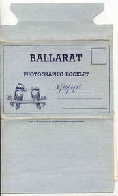
Postcard - Folder set, Valentine & Sons Publishing Co, "Ballarat Photographic Booklet", 1940's
Shows views of the Ballarat CBD and nearby features in the 1930's and 1940's of views of Ballarat, including some trams in the photographs. Demonstrates production of souvenirs of the era - folded postcards. The photos could also be used for individual postcards.Set of 9 black and white views of Ballarat printed on a folded strip, glued within a blue colour light weight cardboard folder, titled "Ballarat Photographic Booklet". Booklet printed with an address area with title and kookaburras. Produced by The Valentine Publishing Co. Pty Ltd Melbourne & Sydney The rear has a slit on the rear cover that allowed the folder to be secured. Pictures are: 1. Panorama from Sturt Street, looking up Bridge St 2. City Hall 3. The Avenue of Honour (14 Miles Long) 4. Lake Wendouree 5. King George V. Memorial 6. The Pergola, Botanical Gardens 7. Eureka Stockade 8. Lydiard Street, showing Craig's Hotel 9. Sturt Street, Ballarat. Made during 1940, with photographs of the 1930's as well given motor cars in the photo. Has a date of "5/10/1951" on the front cover in ink. Has a date of "5/10/1951" on the front cover in ink.trams, tramways, sturt st, town hall, lake wendouree, memorial arch avenue of honour, memorial, gardens, lydiard st, eureka -
 Ballarat Tramway Museum
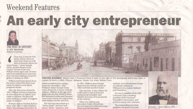
Newspaper, Dot Wickham, "An early city entrepreneur", 5/03/2005 12:00:00 AM
Yields information about William Irwin, Irwins Provincial Hotel and the tram line in Lydiard St Nth.Newspaper clipping from The Courier, 5 March 2005, titled "An early city entrepreneur" written by Dot Wickham about William Irwin, the proprietor of Irwin's Provincial Hotel. Gives a brief history of William Irwin, his Ballarat hotels, his local and other activities. Features a photo of Lydiard St Nth looking south from the railway level crossing with the horse tram lines in the photograph and Irwins Provincial Hotel on the right hand side, before reconstruction to a two story building.hotels, lydiard st nth -
 Ballarat Tramway Museum
Photograph - Black & White Photograph/s, John Murray, Jun. 1969
Black and white photograph of Ballarat 27 departing the City Terminus, corner of Sturt and Lydiard Sts. Tram has the a SEC, a SEC roof advertisement. Craigs Hotel and National Mutual building buildings in the background. Photo by John Murray, c1969.On rear, written in black ink "SECV Ballarat No. 27 / c1969 / 18/23"tramways, trams, city terminus, sturt st, tram 27 -
 Ballarat Tramway Museum
Book, Ballarat Litho & Printing Co, "The Picturesque Folio of Ballarat - 'The Modern Athens", 1904
Forty two page book with red covers, titled "The Picturesque Folio of Ballarat - 'The Modern Athens". Sheets have been individually printed both sides, stapled and then glued to the covers. Cover - gives title and printer details First sheet - with a greetings sheet for Good wishes and seasons greetings. Has a printed date of 1905. See Inscriptions. Dated 22/11/1904. Pages 3 - 10 - a historical sketch of Ballarat, compiled by Lieut-Colonel R. W. Williams V.D. Pages 12 - 41 - photos of Ballarat and district - such as: Sturt St The Lakes Post Office - note the trams clock board - taken at corner of Lydiard and Sturt Streets, looking east. The Gardens Queen Victoria Square Lydiard and Sturt St with a horse tram in the photo Victoria Park Eureka Monument The Statues Botanical Gardens Benevolent Asylum Hospital The City Oval - Richards & Co Photograph Fairy Land - the Lake Railway Station with a D class loco waiting for a signal, 3 post home before the level crossing. Has Irwin's Provincial hotel in view. Gong Gong Lake School of Mines and Methodist Church Lake Fountain A Ballarat view - 1853 - 54. View Point Gong Gong reservoir embankment South Star Mine Lal Lal Falls Band & Loch Mine On last page has the logo for the printers - Ballarat Litho & Printing Co, successors to F. W. Niven & Co. 56 and 58 Lydiard St. Ballarat. PDF scan of book added 21/9/2019 as btm3326i.pdfOn first page in black ink " to Chorus? Dodds, from Robert Dodds, and dated 22 Nov 1904.trams, tramways, ballarat, horse trams, sturt st, gardens, railway station, hospital -
 Ballarat Tramway Museum
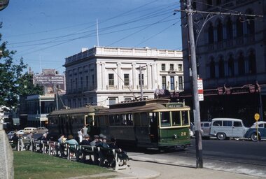
Slide - 35mm slide/s, Ben Parle, Jan. 1954
Kodachrome Transparency - 35mm slide - cardboard mount, with one side with red border and words "Kodachrome Transparency" top and bottom. On the other side is "Made in England" and "View from this side". Photo taken by Ben Parle 1/1954. Photo of Ballarat No. 28 and 35? at the City terminus, south side of Sturt St. at Lydiard St. with the Commonwealth Bank, Unicorn Hotel and the Ballarat Mechanics Institute buildings in the background. Number of potential passengers waiting at the stop. Note the tram stop signs. No. 28 has the destination of Gray St. Sebastopol. Note the verandah on the National Mutual Life building and the portable "No Parking" sign on the right hand side of the photograph. For high resolution scan see btm2813h.tif "Sturt St Ballarat" "1/54"tramways, trams, city terminus, lydiard st north, sturt st, tram 28, tram 35 -
 Ballarat Tramway Museum
Slide - 35mm slide/s, Ben Parle, Jan. 1954
Kodachrome Transparency - 35mm slide - cardboard mount, with one side with red border and words "Kodachrome Transparency" top and bottom. On the other side is "Made in England" and "View from this side". Photo taken by Ben Parle 1/1954. Photo of Ballarat No. 40 at the intersection of Sturt St. at Lydiard St. with the Commonwealth Bank, Unicorn Hotel and the Ballarat Mechanics Institute, Ballarat Gas Company buildings in the background. Tram has the destination of Gardens via?. For high resolution scan see btm2814h.tif "Sturt St Ballarat" "1/54"tramways, trams, city terminus, lydiard st north, sturt st, tram 40 -
 Ballarat Tramway Museum
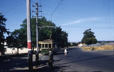
Slide - 35mm slide/s, Ben Parle, Jan. 1954
Kodachrome Transparency - 35mm slide - cardboard mount, with one side with red border and words "Kodachrome Transparency" top and bottom. On the other side is "Made in England" and "View from this side". Photo taken by Ben Parle 1/1954. Photo of Ballarat No. 14, nearing the View Point Hotel stop, Wendouree Parade, southbound past the View Point Hotel with the grounds of Nazareth House in the background on the right hand side. Tram has the destination of CITY. Assumes a follow on slide from Reg. item 2825, as car number obscured. For high resolution scan see btm2826h.tif "Depot Ballarat" "1/54"tramways, trams, wendouree parade, view point, tram 14 -
 Ballarat Tramway Museum
Film - Movie Film & Box, Kodak, 1960 to 1971
Yields information in movie film format of Ballarat trams in 1960 through to 1971, how the system operated and was used by people, including special trams., Yields information in movie film format of Ballarat trams in 1960 through to 1971, how the system operated and was used by people, including special trams.Movie film - 8mm, approx. 15 mins, without leader strip on a plastic reel, within a clear plastic case - Standard 8, titled "Ballarat Trams". See Reg Item 4957 for DVD and Mini DVD. Has been transferred to DVD - see Reg item 4957 Made by Arthur Hill. Also transferred to DVD by Rod Cook Oct. 2015, via Roger Greenwood for use in his DVD, "The City of Ballarat Trams, Gardens & Gold" of 2016. See Reg Item 6883. In Arthur's letter - on file - Made between 1960 and August 1971. Synopsis: based on time. Between 1960 and 1968 0:00 Trams Ahead sign before the Victoria St terminus with 20 at terminus 0.14 - No. 20 leaving Victoria St terminus and being followed along Victoria St by car and then passengers jointing the tram at a tram stop. 00.40 - No. 12 (c1960) in bound along Lydiard St North and arriving in the Gregory St loop. 00.56 - No. 12 and 14 crossing at Gregory St. 01.20 - No. 33 and a bogie car crossing at depot loop. 01.31 - No. 18 travelling along Wendouree Parade with the Lake in the background. 01.42 - No 41 at depot junction and running into the depot No. 2 road with a short sequence of a tramway signal. 02.17 - SEC Sign at the depot gate, shot of 41 in No. 2 road, with the lights other way around, Caution beware of trams sign and a red signal. 02.31- Timetable sign at Gardens Loop 02.36 - No. 30 arriving at Loop and view of a signal with no lights showing. 02.48 - Destination roll being changed through a number of destinations. 03.26 - No. 20 arriving at Carlton St loop with the Olympic monument in the background and the red signal light going out. 03.31 - a lady standing at the front of No. 20, with an ice cream in hand, and No. 17 arriving at the Carlton St loop with a short sped up sequence and No. 20 departing from the loop, followed by No. 17 leaving the loop, heading into the city. 03.41 - No. 13 inbound from Sebastopol crossing Albert St and heading into the city. 04.12 - view of signal and contactor, the light going green and the tram passing underneath. 04.24 - No. 12 at the Sebastopol terminus and departing. 04.51 - No. 12 crossing Albert St Sebastopol. 05.16 - Following No. 12 along Albert St, with Borough Offices in background initially. 05.28 - No. 12 arriving at the Grey St loop with No. 14 arriving at the loop from the city and both trams departing. March 1971 05.58 - No. 30 being followed along Barkly St, Mt Pleasant and the pole being turned at the terminus 06.32 - No. 30 picking up a lady passenger. 06.38 - view from the front of a tram, with the drivers hand and a cigarette, view from the back of the tram, along the Mt Pleasant route and running through the loop and then turning into Main St - has the Ballarat (East) fire station in one sequence, and finally running along Main St. 07.35 - view from tram, with car turning into Bridge St. and then running into Sturt St passed the Parking Loop, and along Sturt St. 08.32 - Points at Drummond St North being changed, doors changed over and the tram running along Drummond St. North, through the Mill St loop and into Macarthur St and in Wendouree Parade, with the Lake Wendouree in view and crossing No. 12 at the Depot Loop, with crews chatting, past the depot, a lady passenger getting off the tram near Forest St., and arriving at Gardens Loop with the same lady passenger who got on in Barkly St, getting off the tram. 11.09 - view of No. 30 at Gardens Loop, departing the loop. August 1971 11.30 - R761 crossing Melton (Exford Wier) on the special train to Ballarat and then the bridge between Ballan and Gordon Stations. 12.16 - View from the front of a tram, following No. 26 along Lydiard St North, crossing at Gregory St and returning to the City. 12.39 - No. 14 and one other tram running along Albert St to Sebastopol, crossing No. 21 at Grey St and then to Sebastopol terminus, crossing Albert St and return and running along Albert St. 13.36 - No. 26, 39 crossing 13 at Gardens Loop. 14.00 - view looking across Lake Wendouree. 14.07 - 26 arriving at Victoria St, running part of Destination roll, passengers getting off with hotel in the background, trolley pole being turned and then with 39 following tram along Victoria St, crossing at the King St Loop. 15.07 - view of a trolley pole tracking through the overhead at curve 15.10 - end. Written labels giving title information on reel.trams, tramways, ballarat, sebastopol, lydiard st north, victoria st, mt pleasant, lake wendouree, depot, tram 12, tram 13, tram 14, tram 17, tram 18, tram 21, tram 26, tram 33, tram 39, tram 41 -
 Ballarat Tramway Museum
Photograph - Digital image Set of 10, 1971
Yields information about Ballarat Tramways and trams prior to the closure of the tramway system.Set of 10 digital images of Ballarat trams prior to closure, scanned from original slides by Stuart Lodington, 1971 prior to closure of the system. .1 - No. 17 at the City Centre, Sturt St, south side, with Gardens via Sturt St on destination roll. Can see the ESCo switch box in the back and the stop and section sign on the adjacent pole. .2 - No. 26 at Sebastopol terminus alongside the Royal Mail Hotel. The tram has yet to turn the pole or the destination roll. Note the Bus Stop sign on the pole, just prior to closure. .3 - ditto .4 - No. 27 and 30 crossing in Skipton St at the Bell St loop (see also btm4975i3) .5 - No. 32, Gardens, about to enter the Carlton St loop, with Lake Wendouree in background, Wendouree Parade. .6 - No. 32 at Depot junction, good photo of depot trackwork entry area. .7 - No. 21, Wendouree Parade, Gardens area, north bound, showing Gardens via Sturt. .8 - No. 12, inbound on Sturt St west at a tram stop. Has destination of Mt. Pleasant. .9 - No. 27 at Lydiard St north terminus with the shelter in the background. .10 - No. 21 at Gardens Loop, tram has destination of Mt. Pleasant. Crews sitting in the saloon.trams, tramways, ballarat, sturt st, sebastopol, drummond st sth, wendouree parade, carlton st, depot, depot junction, trackwork, gardens, sturt st west, crews, tram 17, tram 26, tram 27, tram 32, tram 21, tram 12 -
 Ballarat Tramway Museum
Photograph - Black & White Photograph/s - set of 2, c1912
Yields information about the form and style of the early Geelong trams.Black and white photograph, printed onto card (inkjet printer?) of Geelong Cross bench tram No. 11 in Corio Tce, now Brougham St outside Marks Hotel. Tram has the destination of Newtown. Two copies held. 4316.2 - same photograph printed on photographic paper - supplied by Peter Duckett - two copies held. Photograph used in Destination City, page 46.4316.1 Copy 1 - " Corio Tce, now Brougham St, outside Mark's Hotel, car travelling toward the Depot nearby - Geelong Hist Soc / W F S Collection." Copy 2 on rear "William F. Scott Collection / Geelong Hist Soc / W F S Collection" 4316.2 Copy 1 - On rear, stamped in black ink "Photo supplied from P.W. Duckett Collection, All Rights Reserved, 69 Howitt Rd. Nth Caulfield 3161." Copy 2 - On rear, stamped in black ink "Photo supplied from P.W. Duckett Collection, All Rights Reserved, 69 Howitt Rd. Nth Caulfield 3161." In the bottom right hand corner, a "William F Scott" address label in the bottom left hand corner.trams, tramways, geelong, depot, brougham st, tram 11 -
 Ballarat Tramway Museum
Photograph - Black & White Photograph/s, Wal Jack, Easter Saturday 1941
Black and White print contained within the Wal Jack Bendigo and Geelong Album, see Reg Item 5003 for more details. Photograph of ESCo tram No. 1 arriving at the Eaglehawk terminus. The tram has been modified with bracing and open saloon seats changed from cross bench to longitudinal. The conductor is sitting in the front saloon. The tram has the destination of "City". In the background is the Park Hotel, and Sports Depot business. i1 - scan of print in the album i2 - rear of image i3 - scan of negative at 3200dpi added 6/6/2020. On rear in ink "T193, Bendigo Tramways, State Electricity Commission, / No. 1 (Original type), High St Eaglehawk, Easter Saturday 1941. W. Jack photo. trams, tramways, bendigo, esco, secv, eaglehawk, high st, tram 1 -
 Ballarat Tramway Museum
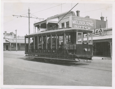
Photograph - Black & White Photograph/s, Wal Jack, Easter 1941
Black and White print contained within the Wal Jack Bendigo and Geelong Album, see Reg Item 5003 for more details. Photo of No. 18 in High St Eaglehawk with O'Shea's Victoria Hotel in the background.. Tram has the destination of City on the rear window. i1 - scan of print in the album i2 - rear of image i3 - scan of negative at 3200dpi added 7/6/2020. On rear in ink "T192, Bendigo Tramways, No. 18 High St. Eaglehawk, Easter 1941" and in bottom right hand corner "Photo W. Jack".trams, tramways, bendigo, eaglehawk, high st, tram 18 -
 Ballarat Tramway Museum
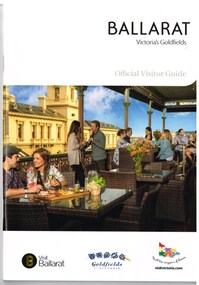
Book, The Ballarat Visitor Information Centre, "Ballarat Victoria's goldfields Official Visitor Guide", 2015
Full colour, 84 page, book, A5 size titled "Ballarat Victoria's goldfields Official Visitor Guide", with a photo of a people eating on the verandah of the hotel opposite the old post office. Gives details, maps accommodation listing, attractions etc of the Ballarat area. Page 14 detail the Ballarat Tramway Museum. Inside rear cover is a fold out map of the district, city centre, Buninyong and Mt Helen and Ballarat and Surrounds. Published 2015 by The Ballarat Visitor Information Centre. trams, tramways, ballarat, visitors, tourist guides, btm, gardens -
 Ballarat Tramway Museum
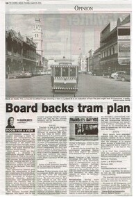
Newspaper, The Courier Ballarat, "Board back tram plan", 29/08/2002 12:00:00 AM
Yields information about the view of the Executive Director of Ballarat Tourism about the proposal for a Ballarat Tourist based tramway in 2002.Newspaper clipping from the Courier, Thursday 29 August 2002, titled "Board back tram plan" about the Ballarat Tourism Board supporting the construction of tourist based tramway in Ballarat, written by the Executive Director of Ballarat Tourism. Features a digital image of BTM tram 13 in Lydiard St North with the Post Office and George Hotel in the background. Gives information about the benefits of the proposal for Ballarat. ballarat revival, btm, lydiard st north, city tramway -
 Ballarat Tramway Museum
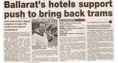
Newspaper, The Courier Ballarat, "Ballarat's hotel support push to bring back trams", 26/07/2002 12:00:00 AM
... Revival BTM Hotels City Tramway Tourism Item has the date, source ...Yields information about the view of the view of the Australian Hotels Association about the proposal for a Ballarat Tourist based tramway in 2002.Newspaper clipping from the Courier, Friday 26 July 2002, titled "Ballarat's hotel support push to bring back trams", written by Leonie Barlow about the Australian Hotels Association Country Vice President Ian Larkin supporting the City tramway, as a boost to tourism. Notes the forthcoming information session for July 30.Item has the date, source and page written in ink.ballarat revival, btm, hotels, city tramway, tourism -
 Ballarat Tramway Museum
Photograph - Digital image Set of 10, Tony Smith, 1971
Yields information about Ballarat Tramways and trams prior to the closure of the tramway system.Set of 10 digital images of Ballarat trams prior to closure, scanned from original slides by Tony Smith, 1971 prior to closure of the system. .1 - 41 and four other single truckers in the City Loop - Sturt St - has Dickins, Gear Chemist, Egments - Hartleys in the background. .2 - 33 northbound in Drummond St North with a large semi trailer behind it. .3 - Scrubber tram on 0 road at the depot. .4 - 43 in Lydiard St North .5 - 37? at Sebastopol terminus with the Royal Hotel in the Background. .6 - 37, Albert St, south of Ophir St crossover, northbound - photo not in focus. .7 - 37 at the Grey St loop, northbound. .8 - 37 and 34? - Urquhart St loop? - not in focus. .9 - 11 - Sturt St, showing Victoria St destination. .10 - 37 - climbing the Lydiard St hill, tram showing Sebastopol.trams, tramways, city loop, sturt st, lydiard st north, drummond st nth, depot, grey st loop, albert st, urquhart st, tram 41, tram 33, tram scrubber, tram 43, tram 37, tram 34, tram 11 -
 Ballarat Tramway Museum
Photograph - Digital image Set of 10, Tony Smith, 1971
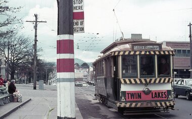
Yields information about Ballarat Tramways and trams prior to the closure of the tramway system.Set of 10 digital images of Ballarat trams prior to closure, scanned from original slides by Tony Smith, 1971 prior to closure of the system. .1 - 13 at the Parker St loop, Sturt St west waiting for another tram to arrive - Mercedes Benz car pull out around the stationary tramcar. .2 - 13 and another single trucker at the City terminus, north side of Sturt St. Note the conductor in the distance with a point bar about to hop onto the tram turning into Lydiard St North. Has the Post Office in the background. .3 - 26 arriving at the City stop, with the Mechanics Institute and Cooks Provide Hotel in the background. Tram has destination of Gardens via Drummond St North. .4 - 33 and 12 in Lydiard St Nth at Sturt St. 33 (Lydiard St Nth), 12 (Sebastopol). Has the post office and other buildings in the background .5 - 12 and 26 at city stop, south side with Town Hall and Myers in the background. 12 has destination of Sebastopol. .6 - 12 at intersection of Drummond St and Sturt St with Mobil petrol station in background and ad for Marshall batteries. Has the tram stop sign on the left hand side. Tram has destination of Sebastopol and a Twin Lakes sign. .7 - 30 northbound in Drummond St south at Sturt St about to turn into Sturt St. Has destination of Lydiard St Nth. Has the Southern Cross hotel in the background. .8 - 31 turning from Drummond St North into Sturt St, en route to Victoria St with the Shell service station in the background. Hospital Corner. Tram has roof advertisements for Johnnie Walker whisky. .9 - 30 and 31 (from above photos) in Sturt St. .10 - Tony Smith standing on the doorstep of 26 at Mt Pleasant terminus. Has the store in the background with The Sun and Robur tea adverts. trams, tramways, parker st loop, sturt st west, sturt st, conductors, drummond st, hospital corner, mt pleasant, tram 13, tram 26, tram 12, tram 30, tram 33 -
 Ballarat Tramway Museum
Photograph - Digital image Set of 10, Tony Smith, 19/09/1971 12:00:00 AM
Yields information about Ballarat Tramways and trams prior to the closure of the tramway system.Set of 10 digital images of Ballarat trams prior to closure, scanned from original slides by Tony Smith, 1971 prior to closure of the system. This set of slides appears to be the last day of operations - 19/9/1971 .1 - 40 in Drummond St Nth. near Macarthur St, showing Sebastopol. .2 - 35 turning from Drummond St north into Sturt St with the Southern Cross hotel in the background. Note the shoes in the overhead. .3 - 42 in Drummond St North, showing Special, nearing Sturt St. .4 - 42 turning into Sturt St, with the Shell Service station on the left. .5 - 42 reversing on the Lydiard St Nth crossover with the post office in the background. Tram showing Sebastopol. .6 - 39 reversing at Grenville St, tram showing Special. Has the Dickins and the Gasometer in the background. the conductor adjusting the trolley ropes. .7 - 39 running from Bridge St into Sturt St - as above. .8 - 34 and 39? parked in the City Loop. Has Patersons furniture, Gear Chemist and Edments stores in the background. .9 - 43 showing special at the Sturt and Lydiard St stop with 39? about to leave Lydiard St Nth. Has the post office in the background. .10 - 40 at the Lydiard St North terminus, with passengers boarding. Cemetery gates in the background.trams, tramways, drummond st nth, macarthur st, sturt st, closure, lydiard st nth, grenville st, city loop, closure, tram 40, tram 35, tram 42, tram 39, tram 34