Showing 15695 items
matching docuents-maps-france
-
 Dandenong/Cranbourne RSL Sub Branch
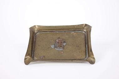
Souvenir - Ashtray, circa 1920
World War I ashtray made in Ypres, France'Trench Art' ashtray with coat of arms in centre. rectangular, made in brass with cigarette holder grooves at each corner Coat of arms, vertical rectangle with small point as base, surmounted by open crown. Top third of shield features Cross of Lorraine on burgundy background, lower two thirds contains textured cross. ashtray, trench art, wwi -
 Flagstaff Hill Maritime Museum and Village
Map - Survey Map, F.F. McGovern, Yangery - County of Villiers, 1884
A surveyor was employed to measure the land designated as Yangery, County of Villiers, in the Borough of Warrnambool. The area on the map is similar to the earlier Farnham Survey undertaken by William Rutledge in the 1850's. Warrnambool was a Borough between 1863-1883. Coutours, waterways, sea and other significant points are shown. The distances are accurately measured. This survey map was used for planning future land sales, recreation areas and roads. WILLIAM RUTLEDGE (1806-1876) William Rutledge surveyed the land known as Farnham in southwest Victoria in 1843. His tenants made him a profitable business from working the land there. In 1863 Rutledge moved from nearby Port Fairy to Farnham and became very successful in breeding sheep, which he imported from J.R. Kirkham of Lincolnshire, England. He also bred horses on his land. The survey map of Yangery is important for its connection with renowned surveyor William Rutledge. The map shows the growth of landholders in the district when compared to the original Rutledge survey of the 1850's.Survey map of Yangery, titled "Yangery - County of Villiers". Printed on white paper, mounted on brown paper. c. 1863-1876. Comments printed on the Map include; Special Survey by William Rutledge, Photo-lithographed at the Department of Lands and Survey, Melbourne by W.J. Burson, Price 1/- [one shilling]. Scale is in Chains. Map has boundaries of Koroit Borough, Meerai, Purnim, Wangoom, Borough of Warrnambool, Mentions the Proposal of Tower HIll for Public Recreation. The map names the owners of the land at that time. Hand written pencil marks and figures and "Sauls fence" drawn on map. Hand written pencil markes and figures and "Sauls fence" drawn onto map. "For Department Use only". "Scale: 8 chains to 1 inch" flagstaff hill, warrnambool, shipwrecked-coast, flagstaff-hill, flagstaff-hill-maritime-museum, maritime-museum, shipwreck-coast, flagstaff-hill-maritime-village, county of villiers map, yangery district, w.j. burson, borough of warrnambool, koroit, purnim, meerai, wangoom, proposal of tower hill for public recreation, special survey by william rutledge, william rutledge, farnham, lincolnshire sheep, clydesdale -
 Wodonga & District Historical Society Inc
Map - Australia Shewing the Tracks of the Late Explorers
Charles George Eastland Platts arrived in South Australia on 22 March 1839, and soon after established his business in Adelaide. He became Adelaide’s first bookseller. It was known as Platts’ Library but was also a bookshop and stationer. His business was also used as a postal receiving house. Platts died on 14 November 1871. Boyle Travers Finniss (18 August 1807 – 24 December 1893) had an early career in the British Military before selling off his commission in 1835. He was appointed assistant surveyor to Colonel William Light in South Australia. He then had several roles in public service. Finniss was the first premier and Chief Secretary South Australia, serving from 24 October 1856 to 20 August 1857. In 1864 he was appointed as the Government Resident of the Northern Territory. He was filling this role at the time when the map was produced and is acknowledged on the map.This is a very early map documenting the exploration and opening up of Australia.Map of Australia and part of Indonesia. Part coloured with tracks of 15 explorers including Eyre, Stuart, Leichhardt and Burke and Wills with notes and some details of latitude and longitude. Relief relating to the major mountain ranges is indicated. At the bottom of the map is a key to the explorers and a list of the counties in the different states. Top left side of map has small sketch of the Platts (publisher) building at the corner of King William Street.Map of Australia shewing the tracks of late explorers into the interior and across the continent together with their discoveries map/ projected, compiled and drawn by O.W.O. Bennett Most Respectfully Dedicated to LIEUT. COL. BOYLE TRAVERS FINISS Government Resident of the Northern Territory of SOUTH AUSTRALIAexplorers -- australia -- maps, rare maps australia -
 Glen Eira City Council History and Heritage Collection
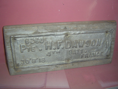
Plaque, memorial
Originally located in the City of Caulfield and City of Brighton Avenues of Honour. Metal plaque on wooden base with embossed lettering: "6260 PTE H.F. DAWSON 4th BATT. 30'8'18 FRANCE""6260 PTE H.F. DAWSON 4th BATT. 30'8'18 FRANCE" embossed on metal. -
 Kiewa Valley Historical Society
Map - Topographical, Ski Club of Victoria Bogong High Plains and Adjacent Peaks, Early 1930's
This map has been in the Ryder family for approx. 70 years. Probably used when bush walking and skiing in the early days on the Bogong High Plains. The Ryder family are farmers in the Kiewa Valley and were involved in taking their cattle up to the Bogong High Plains where they had a lease. The State Electricity Commission of Victoria constructed the Kiewa Hydro Electric Scheme opening up the area during the 1940's and 1950's. This type of map is an early one, used by people in the Kiewa Valley and possibly by surveyors prior to construction.The map is an early topographic map used by farmers living in the Kiewa Valley. It is historically significant as these people were involved in taking cattle up to the High Plains during summer and may have been used for bush walking and skiing.This is a sepia coloured paper map which was originally printed copyright registered. It was revised in 20/6.33/4.4.37/8.4.40/24.8.43/19/6/54. It shows roads / tracks / snow poles / snow pole numbers (27) / Snow pole spacing (3 chains. 66 yards) approximately 27 poles to the mile / height above sea level in feet - 5280. Water courses not definitely located etc.Rocky Valley Dam (Kiewa Hydro Electric Scheme) has been drawn on the map by hand with a biro. There is a wooden rod at the top of the map.topographic map; kiewa valley; ryder family; high plains of victoria -
 Flagstaff Hill Maritime Museum and Village
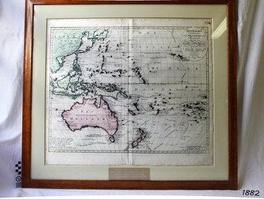
Map, Australien (Sudland) auch Polynesien oder Inselwelt, insgemein der funfte Welltheil, c.1990
This map is a reprint of Johann (Johannes) Walch’s “Australien (Sudland) auch Polynesien oder Inselwelt, insgemein der funfte Welltheil”, published in 1802. It shows Australia, New Zealand, South East Asia and the Pacific Islands shows a large number of places names, many of which have changed since the map was drawn. The map includes the routes and dates of the voyages of Tasman, Cook, Bougainville, Carteret, Byron, and others up to 1802. The shapes of the lands on this early map show that some of the areas had not yet been charted. The map was donated to Flagstaff Hill Maritime Village in April 1990 by the Group Study Exchange Team from Rotary District 233, Sweden. It was framed and presented by Rotary District 978 and presented by Barry Lange, the Governor of District 978 in 1989-90. (District 978, Geelong East, is now District 9780.) Johann (Johannes) Walch Johann Walch, painter and engraver, was born in 1757. He was well known for creating miniature portraits. He gained his training in Geneva, Venice and Rome. His publications include atlases and sheet maps, many of which were reprinted after his death in 1816. This reprint of an 1802 is significant for its historical and geographical contant, showing the voyages of many early explorers to the southern regions of the world including Australia. It also shows the early names used for countries and towns and is a valuable reference to historical interpretation. The map itself is a fine example of hand drawn and hand coloured maps of the early 19th century, the method of production, detail included, layout, symbols and so forth.Map, reprint of Johann (Johannes) Walch’s “Australien (Sudland) auch Polynesien oder Inselwelt, insgemein der funfte Welltheil “, first published by in Ausburg in 1802. The image on this Map No 5B, shows Australia and the south Pacific. The timber framed, glass covered, printed and coloured map was created in two sections and joined. Brass plaque at base of map states that the map was presented to Flagstaff Hill by Rotary International in April 1990. Feint lines used for aligning lettering can be seen on the map and there are large erased letters such as a “D” and “S” that are almost obscured.Plague “ROTARY INTERNATIONAL / THE MAP WAS DONATED BY THE GROUP STUDY EXCHANGE TEAM / FROM ROTARY DISTRICT 233 SWEDEN IN APRIL 1990 / AND WAS FRAMED AND PRESENTED BY ROTARY DISTRICT 978 / BARRY LANGE – GOVERNOR DISTRICT 978 1989/90” Stamped on back “ELLIMINOOK FRAMES / MRS. JILL FALKINER / ELLIMINOOK / BIRREGURRA, VIC. 3242 / PHONE: (052) 36 2080” flagstaff hill, warrnambool, shipwrecked coast, flagstaff hill maritime museum, maritime museum, shipwreck coast, flagstaff hill maritime village, great ocean road, australien (sudland) auch polynesien oder inselwelt, insgemein der funfte welltheil, johann (johannes) walch, cartographer johann (johannes) walch, ausburg publisher johann (johannes) walch, johann (johannes) walch map number 5b, 1802 map of australia and south pacific, rotary international group study exchange team, rotary district 233 sweden, elliminook frames, voyages of tasman, voyages of cook, voyages of bougainville, voyages of carteret, voyages of byron, barry lange, painter of miniature portraits johann (johannes) walch -
 Victorian Aboriginal Corporation for Languages
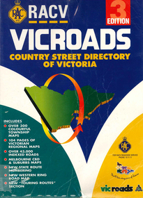
Book, Royal Automobile Club of Victoria, Vicroads country street directory of Victoria, 1997
Country street directory which contains maps, lists, and tourist information.Maps, colour photographsroad maps -
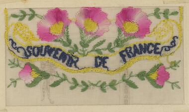
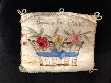 Mont De Lancey
Handkerchief Sachet, 1916
Sent by James Clegg to his sister, Daisy from France 1916.Embroidered handkerchief sachet with three (3) flowers in basket on front."Souvenir from France"handkerchief bags, handkerchiefs -
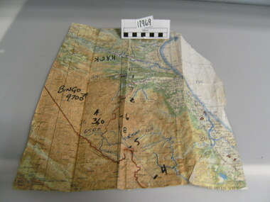 National Vietnam Veterans Museum (NVVM)
Map
A very damaged well used map which has been jointed together. It appears to be Northern Section of vietnam with numbers written in black texta (Hack, Bingo 9700) on front.On back of map hand written "Mission into the North. Planned both directions".Topagraphical Mapmap, alan reed -
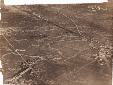 The Beechworth Burke Museum
Photograph, c1914
Aerial photograph of a battle field in France during World War OneBlack and white rectangular photograph printed on photographic paperObverse: Railway / British Line (in pen) / Reverse: Villers Brut /military album, burke museum, beechworth, beechworth museum, world war one, wwi, trenches, aerial photo, aerial photo trenches -
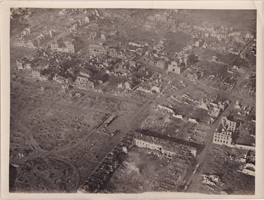 The Beechworth Burke Museum
Photograph, c1914
Aerial photograph of a battle field in France during World War OneBlack and white rectangular photograph printed on photographic paperReverse: 6534 / Australian Official Photographs, No. E1253 /military album, burke museum, beechworth, beechworth museum, world war war, wwi, trenches, aerial photo, battlefield -
 Federation University Historical Collection
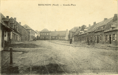
Postcard - black and white, Grande-Place, Boeschepe, c1914
Boeschepe is a commune in the Nord department in northern France, next to the Belgian border.Black and white postcard showing a number of buildings lining an unmade road. chatham-holmes family collection, boeschepe, france, world war, world war 1, grande place -
 Warrnambool and District Historical Society Inc.
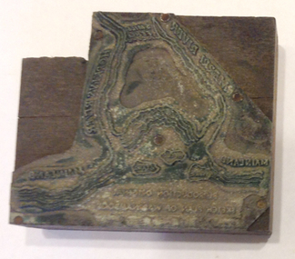
Functional object - Printing block: Warrnambool Historical Society logo, 1980s
This printers block was made for the Warrnambool and District Historical Society and used to print letterheads, envelopes and cards. The impression on the block is of the sketch map drawn by Thomas Price of Port Fairy of the Warrnambool Harbour site when he wrote to Superintendent Charles LaTrobe in 1844 regarding the suitability of the site for a new town. The letter is regarded as an important impetus for La Trobe to consider establishing the town of Warrnambool and so the sketch was used by the Historical Society as its logo on letterheads etc for many years. It was also used as the heading for the Society newsletters from the late 1980s to late 2007.This block of the Thomas Price sketch was used by the Historical Society for many years for its printed material and the sketch was used as its logo for about 20 years so it is an important part of the Society’s history and the block is kept as a reminder of this.This is a printing block with an impression made of metal and attached to a wooden block. The wood is in layers of dark and light coloured wood and has a piece cut out at the top left hand corner. The impression is a representation of the sketch map of Warrnambool Harbour made by Thomas Price in 1844.Sketch map of Warrnambool Harbour 1844warrnambool & district historical society, thomas price sketch -
 Bendigo Military Museum
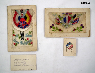
Postcard - POSTCARDS WW1
Postcards from “Patrick Joesph Frawley”. Enlisted No 563 on 6.4.1915 age 21 years in 13th Light Horse B Sqd, embarked for Eygpt 28.5.1915, record is unclear as states again embarked 5.9.1915 and then disembark Eygpt from Mudros early 1916, does not clearly state going to Gallipoli. Hospital 27.4.1916 (unclear) rejoin unit 28.4.1916, embark for France 2.6.1916, taken on strength of 1st Anzac Army Corps LH Regt 7.7.1916, hospital 4.10.1917 with “Boils, Debility”, from here he is diagnosed with Chronic Bronchitis and returns to Australia 21.4.1918, discharged Medically unfit 17.7.1918.1. White postcard. French writing and address on back. Front has silk embroidered material attached with a small card in pocket. Embroidered image of woman in dress with UK/Belgium/French flags on it. 2. Small card with picture of child holding presents, playing in the snow and message "A Loving Kiss" and message on back., 3. White postcard. On back a short message. On front silk embroidered pocket. Embroidered flags of UK, France, Belgium, Italy and one other. 4. Small folded card with French flag on front & 1916, and message inside.1. Address on back "Mrs. A.D. Norman, 52 Laity St, Richmond, Vict". 2. Message on back "From where I am Lila, Best Love xxxx". 3. Written on card, No, Division and short message. 4. Written on card "Greetings from France" and "P.J. Frawley - to my Love". postcards, france -
 4th/19th Prince of Wales's Light Horse Regiment Unit History Room
Certificate (Medical), Certificate to be given to all NCO's and men proceeding on leave, 7/5/1917
Certificate was issued to No 1175 Kennedy J (rank not clear) of 23 Bn AIFA certificate issued to all nco's and men proceeding on leave, certifying that the bearer is free from vermin and scabies.Signed by Capt Miralyin (?) RAMC on 7/5/17 On back is written "Souvenir of my furlough from France saying that I am free from (chats)"certificate, medical, ww1, vermin -
 Running Rabbits Military Museum operated by the Upwey Belgrave RSL Sub Branch
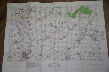
Map St Quentin
Trench Map France Sheet 62Bshowing area around St Quentin.documents, ww1, army -
 Federation University Historical Collection
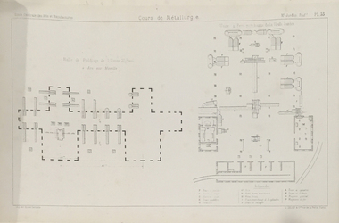
Booklet, Professor Samson Jordon, Cours de Metallurgie (album des planches), c1875
Professor S. Jordon worked at the Ecole Centrale des Arts et Manufactures, France.Brown cloth covered book with black leather spine, with many drawings. metallurgy, books, s. jordan, france, ecole centrale des arts et manufactures, samson jordon -
 Warrnambool and District Historical Society Inc.
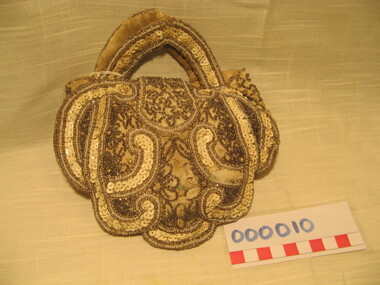
Domestic object - Ladies evening purse, C1900
Dame Nellie Melba was born Helen Porter Mitchell in 1861 and took the stage name of Melba after her home town of Melbourne. Dame Nellie went on to become one of the most successful and highly regarded sopranoes of the late 19th a nd early 20th centuries. She had a number of Farewell tours as she neared the end of her career. When Dame Nellie Melba was a house guest of Miss Florence Lake at "Lyndoch" Warrnambool during her farewell tour in 1927. The bag was purported to have been given to a house maid in recognition of favours done. An item owned by Dame Nellie Melba............ WDHS also has a program from Dame Nellie Melba's Farewell Tour.Ladies evening purse "Made in France" Beige/ecru silk on canvas backing, heavily beaded and sequinned in beige and coffee, some pearl decoration, with an ornate enamelled button closure mechanism for a press stud. Two fabric handles also heavily beaded. A scalloped shape with gusseted side insertions.Bag is too fragile to open.nellie melba, evening bag, warrnambool, lyndoch warrnambool, florence lake, warrnambool -
 Whitehorse Historical Society Inc.
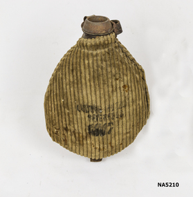
Functional object - Water Bottle
French. Collected by Charles Henry Honybun during World War One.A French water bottle covered in brown corduroy materialhonybun, first world war, france -
 Wodonga & District Historical Society Inc
Map - Tulloch & Brown's Map of the Colony of Victoria, Tulloch & Brown, 1856
The map was created by Tulloch and Brown. David Tulloch was one of the earliest engravers and lithographers in the state of Victoria. He arrived in Melbourne from Greenock, Scotland, on 3 January 1849. Following the discovery of gold Tulloch went to the Victorian goldfields in 1851, commissioned to make sketches of the diggers and the diggings for Ham’s Illustrated Australian Magazine. In November 1852 Tulloch set up in business as engraver, draughtsman, copperplate printer and lithographer. Tulloch took a map engraver, James Davie Brown, into partnership in March 1853; the several maps and specimens of commercial engraving they showed at the 1854 Melbourne Exhibition were awarded a bronze medal. That year Tulloch and Brown also received a silver medal at the Victorian Industrial Exhibition. The partnership was dissolved towards the end of 1856.This is a very early map of the Colony of Victoria including Belvoir (now know as Wodonga).A foldable map mounted on linen and with a board cover. It records the Colony of Victoria according to Surveyor's Records revised in 1857. Areas of the map are shaded to highlight different counties.At bottom right hand section of map: Tulloch & Brown's map of the Colony of Victoria : comprising part of New South Wales, the boundaries, counties, also seaport & inland townships, the gold fields with the latest discoveries, roads, tracks, &c. &c. / compiled from drawings in the Survey Office and correctly revised till 1857. Respectfully dedicated by Permission, to the Honorable Captain Andrew Clarke R.E. Surveyor General of Victoria by His Obediant Servants Tulloch & Brown, Engravers & Publishers, Melbourne". At bottom right below border : Published as the Act directs by the Proprietors, Melbourne, 1st Feb. 1856. tulloch and brown maps, rare maps victoria, victorian cartography -
 Wangaratta RSL Sub Branch
Postcard - Embroidered Postcard, c. 1917
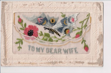
Postcard from WWI soldier William West (1268) of the 29 Infantry Battalion, 5th Pioneers Battalion while posted in France to his family at home, 1917. Mentioned in postcard George Buse 2208 born Yarraville who enlisted on 10/9/1914 aged 21 years 3 months. He embarked on 20/10/1914 and returned to Australia in 1919. He was a Driver with the 10th ASC,Embroidered silk postcards were first made in 1900 for the Paris Exposition. The popularity of silk postcards peaked during the First World War 1914 - 1918.They were mostly embroidered by French women in their homes and then sent to the factories for cutting and mounting on cards. Many of the cards were illustrated with patriotic symbols, flags, slogans, or sentimental texts. During the First World War, many Allied officers and soldiers based in France sent silk embroidered postcards to their loved ones back homeWhite rectangular postcard with embroidered pink flowers, green foliate and blue winged butterfly decoration on front. Handwritten message on the back.Front: "To my dear Wife" (embroidered) Back: "To Enid from dad xx / xxxxxx / France / Feb 26/2/1917 / My Dear Alice / Just a PC to let you I'm still well and hope are all the same I have not see Joe lately I may see him sometime or the other I hope you enjoyed yourself on your holidays they will do you good. I'm in a rest station I have not been too well I think I will be back with the battalion in a few days you can tell ??[ma]?? I met Pugger Loney he is in the 15 ambulance he looks well and it just as fat as ever I'm goin gover to see youn George Buse tomorrow well I have not much new to tell only all is well so I will now close with best love from loving husband Will xxxxxxxx"wwi, postcard, embroidered postcard, william west 1268, george buse 2208 -
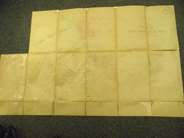 Yarra Glen & District Historical Society
Map, Plan of Yarra Glen Water Area
The map has been used by water supply officers to map the supply of water to properties in the township area of Yarra Glen.The item is significant because it records changes to the supply of water to Yarra Glen over a period of approximately 100 years. It also records property owners and subdivisions.Flat map which folds into 12 pages with a dark red cloth cover. One page in top left corner is missing. Scale of the map is 300 feet to an inch. Cream coloured packing tape has been placed along the back of the folds and is now peeling off.Round stamp in top right corner "Shire of Eltham". Pencil note on top left existing page "Note - includes record of 8 LP's subdivisions. HC". Information has been added to the map over an extended period of time in red ink, black pencil, blue pencil and blue biro.yarra glen/water supply/ -
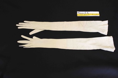
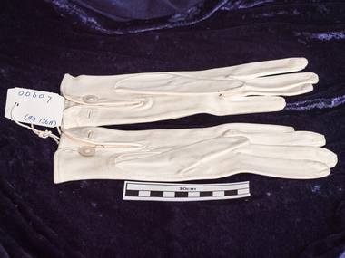 City of Moorabbin Historical Society (Operating the Box Cottage Museum)
Clothing, lady's leather gloves, c1900
This pair of gloves was made in France and purchased by a Moorabbin residentA pair of cream, chamois leather lady's gloves with stitch detailing on back . Size 7 Made in France Size 7craftwork, sewing, gloves, early settlers, market gardeners, moorabbin, bentleigh, mckinnon, ormond, cheltenham, personal effects, evening wear -
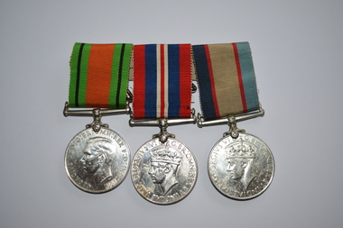 Wangaratta RSL Sub Branch
Medal - Medals WW2
Three original WW2 medals awarded to 51647 Charles William FRENCH born 8.2.1911 at Wahgunyah in Victoria. He enlisted on 2.2.1942. FRENCH served with the RAAF as a Leading Aircraftman and was attached to the 12 Aircraft Repair Depot when discharged on 13.1.1947.1939-1945 War Medal, Australian Service Medal and Defence MedalThree found white metal medals attached to multi striped colour ribbons.51647 C W FRENCHmedal, ww2, raaf -
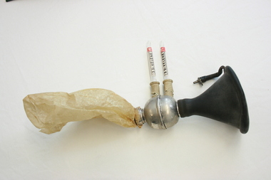 Geoffrey Kaye Museum of Anaesthetic History
Ethyl chloride inhaler, Mid 20th Century
The item was collected by Dr Geoffrey Kaye from a Vichy French military hospital during World war II.The inhaler comprises a black rubber face mask that connects to a metal circular chamber from which two white rubber valves are used to administer the anaesthetic agent. The ethyl chloride vials are labelled 'Kelene', a brand name. A waxed paper rebreather bag is attached to this metal chamer. mask, gas, anaesthesia, rebreather bag, world war ii, dr geoffrey kaye, ethyl chloride, kelene, french, vichy -
 Bendigo Historical Society Inc.
Postcard - BLANCHE SLY POSTCARD COLLECTION, 1900 - 1920
Postcard Album of Blanche Sly. Postcards stored in Folder 81 (49 postcards). 1403.1 - 1403.28 Grey linen look cover with picture of a small sailing boat pasted centre front pf cover. Partly torn sticker on lower LH corner. Blanche Victoria SLY Born: 11 Oct 1890, daughter of William and Hannah Sly Address: 1913; Loddon Vale Address: 1980; 100 Barnard Street Bendigo Died: Bendigo 12 June 1982, buried Bendigo G3 William Sly: Born: 1856 at Smythesdale, Victoria Married in Victoria in 1887; Hannah Theilman Died: Bendigo 1937, buried Bendigo G1 Hannah Sly Nee Theilman Born: 1866 Married in Victoria in 1887; William Sly Died: Bendigo 1948, buried Bendigo G3 See additional Research .Postcard Album of Blanche Sly containing 49 postcards. See 1403 Embroidered floral image on silk with the words "Souvenir de France" in blue . Addressee - Blanche Sender - Tommy Dated France 11/10/18postcard, collector, blanche sly -
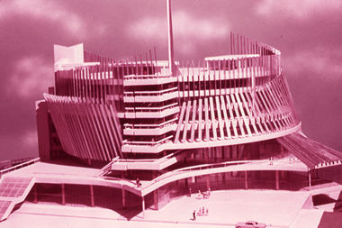 Robin Boyd Foundation
Slide, Commercial, 1967
Robin Boyd was appointed Exhibits Architect for the Australian Pavilion at Expo ‘67 in Montreal. The garden outside the pavilion featured a sculptural pool, a coral display, animal pool, a pit for kangaroos and Eucalypts and other native plants. The indoor exhibits covered aspects of Australian art and culture, architecture, industrial design and scientific innovation, such as the Snowy Mountains Hydro-Electric Power Scheme, the Parkes radio telescope, the design of Canberra, and the Australian way of life.Colour slide in a mount. France Pavilion, Expo '67 Montreal. (Architects: Jean Faugeron and André de Mot.)Expo 67 Montreal Canada / France / April 28 - October 27 / Encircled 12 (Handwritten)expo 67, montreal, robin boyd, slide -
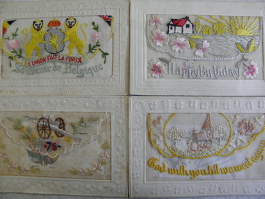 Geelong RSL Sub Branch
Silk Cards, Early 20th Century
The cards are addressed to Harry Newell from his father. One of the small greeting cards is dated 23 June 1916, France.These cards are the originals that Harry Newell received from his father on special occasions e.g. Birthday, good luck, souvenir, till we meet again. Four Embroired Silk Cards, each card has an opening and inside the 'envelope' is another smaller greeting card.All the cards have Fabrication francaise on the back of the card. Each card is addressed to Harry Newell from his Father.silk cards, harry newell -
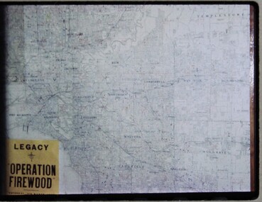 Melbourne Legacy
Slide, Operation Firewood, 1960s
... maps ...Three colour slides of a map of Metropolitan Melbourne with pins showing many delivery addresses. It was during Operation Firewood. Legatees would organise collection of wood from the country and distribute it to widows in metropolitan Melbourne. Other slides show the cutting and loading of wood and delivery to widows in metropolitan Melbourne. Was with many other slides taken in the 1950s and 1960s. The slides have been photographed to make digital images and moved to archive quality sleeves. In many cases the original images were not well focussed and the digital image the best available.A record of Legacy helping widows by sourcing, supplying and delivering firewood. When open fires were the main source of heating, a load of firewood and help moving it, would have been very important to the widows.Colour slide x 3 of a map of Melbourne during Operation Firewood in white cardboard mount.Printed on front in blue ink 'Made in Australia'. Hand written on one slide 'Map of Operation Firewood' in pencil.operation firewood, maps -
 Brighton Historical Society
Accessory - Gloves, 1900
These gloves belonged to Clara Johnstone Miller (nee Bell, 1866-1910). Clara was the only daughter of Mr James Bell, a councillor of the Shire of Leigh (today a part of Golden Plains Shire) and owner of Woolbrook Homestead in Teesdale, near Geelong. In 1888, Clara married prominent businessman, racehorse owner, racing identity and pastoralist Septimus Miller (1854-1925). Septimus was the sixth of seven children born to Henry 'Money' Miller and Eliza Miller (nee Mattinson). 'Money' Miller was a well known financier and politician and reputedly one of Australia's wealthiest people in his time. In 1889, Clara and Septimus moved into the house 'Cantala' in Dandenong Road, Caulfield. They had one child, Gwendoline Stewart Miller, who died in 1902 at the age of thirteen of diabetes - a largely untreatable condition at the time (insulin would not be discovered until 1921). Clara died in 1910, aged only 44. Septimus subsequently married Helen (nee Henderson), with whom he had a son, Ronald (1915-1990). The Millers were buried in the Brighton General Cemetery in a large Gothic-style vault. Upon Clara's death, Septimus sent much of her clothing and Gwendoline's to her mother Mary Bell. Some of these items were passed down to two of Clara's nieces, Miss Mary Bell and Mrs Lois Lillies, who donated them to BHS around 1973.A pair of very fine ivory doeskin evening gloves. The gloves feature full pique insert seams around the fingers and thumb with a slit on the inside arm from mid thumb to mid fore arm and three white shell buttons. The gloves extend high to high on the upper arms and feature a ribbon covered elastic to aid hold on the upper arm. A black ink stamp on the inside of the right glove over the wrist: 5 3/4, Made in France, Buckley and Nunn Limited, Melbourne. A black ink stamp on the inside of the left glove over the wrist: Grand Prix Exposition, 1900, Medallere D'or, Merlier, Depose (? Very faint), Made in France. A blue ink stamp on the inside of the left glove over the top side of the wrist: 797, 221'65, C51Cwoolbrook, septimus miller, henry 'money' miller, gwendoline miller, cantala, clara miller, gloves, caulfield, brighton general cemetery, 1900s fashion, buckley and nunn