Showing 54647 items
matching documents-maps
-
 Marysville & District Historical Society
Map (Item) - Tourist Map, Tourists Resorts' Committee, Tourist's Map of Healesville Marysville and Warburton Districts, 13.10.1925
A tourist map for Healesville, Marysville and Warburton that was produced by the Tourists Resorts' Committee. This map was produced in 1925.A tourist map for Healesville, Marysville and Warburton that was produced by the Tourists Resorts' Committee.Photo Lithographed at the Department of Lands and Survey, Melbourne by W.J. Butson./ 13.10.25healesville, marysville, warburton, victoria, tourists resorts' committee, ben cairn, mount donna buang, the black's spur, the acheron valley, narbethong, launching place, tourist information, tourism, map, tourist map -
 Bendigo Historical Society Inc.
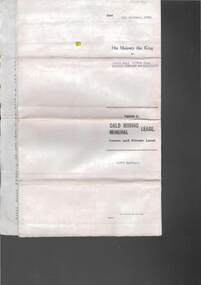
Document - MCCOLL, RANKIN AND STANISTREET COLLECTION:SOUTH NELL GWYNNE GOLD MINING COMPANY NO LIABILITY, 1940
Document: South Nell Gwynne Gold Mining Company No Liability - gold mining lease document no. 11074 Bendigo. Document of 3 pages with map insert.organization, mining, south nell gwynne gold mining co., bendigo, mccoll, rankin & stanistreet -
 Federation University Historical Collection
Map - Plan, Ballarat Deep Leads and Mines, 1992, 1992
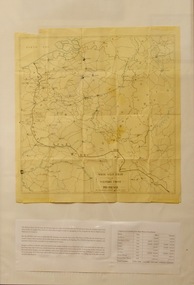
This is Bulletin No. 62: Deep Lead Gold Deposits in Victoria. Map No.6 Ballarat Sheet 1 of 2 The map shows geology, topography and information on mines in the following areas: one large map of the Ballarat area with five enlargements for: Sago Hill District; Scarsdale District; Pitfield Plains District; Berringa Gold Field and Rokewood District. Ballarat Mines and Deep Leads Report No.94 (Finlay and Douglas,1992) provides a summary of the Geological Survey of Victoria mines database, references and geology for most of the mines on this map. Geology Compilation: simplified from earlier Departmental mapping with minor field checking by E.N.M. Plier-Malone. Very large rectangular sheet of paper with seven coloured maps of various sizes and a small green rectangle on the bottom rhs with a map of Victoria superimposed over a poppet head. this rectangle includes information of the other maps shown. The background for these maps is white. Also includes tables of names of mine companies, name of shafts and gold production.gold mines of australia, gold mines of victoria, gold mines- ballarat and district, gold mines pitfield plains district, gold mines scarsdale district, gold mines berringa gold field, gold mines rokewood district, gold mines sago hill district, map - gold mines, map - gold mines in victoria, ballarat, pitfield, scarsdale, berringa, rokewood, sago hill, deep lead gold deposits in victoria, geological survey - gold deposits in victoria, mining, gold deposits in victoria, gold mines in victoria, rokewook, pitfield plains -
 Red Cliffs Military Museum
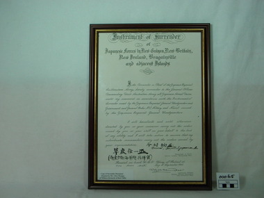
Certificate, Instrument of Surrender, post 1945
Copy of a very important document of an event on the 6th September 1945, that changed the course of the second World War. A copy of the Japanese Surrender Document, in a brown wooden frame, with ornate font in heading.Instrument of Surrender / of /Japanese Forces in New Guinea, New Britain,/ New Ireland, Bougainville / and adjacent Islands./ I, the commander in Chief of the Japanese Imperial/ Southeastern Army, hereby surrender to the General Officer/ Commanding First Australian Army all Japanese Imperial Armed Forces/ under my command in accordance with the instrument of/ Surrender issued by the Japanese Imperial General Headquarters and Government and// General Order No1 Military and Naval issued by the Japanese Imperial Headquarters./ I will henceforth and until otherwise/ directed by you or your successor carrry out the orders/ issued by you or your staff on your behalf to the best/ of my ability and I will take action to ensure that my/ subordinate commanders carry out the orders issued by/ your representatives./ (Japanese signature) General, Imperial jap... (indecipherable)/ Japanese Characters / Japanese Characters / Commander in Chief/ Japanese Imperial Southern Army/ Received on board H.M.S. Glory of Rabaul at/ 1130 hours sixth day of September 1945./ Signature Lieutenant General/ General Officer Commanding / First Australia Army. Caption on front of Document says "Copy of Surrender Document/ Donated by Mr. Clive Morgan/ of Mildura (formerly of Red Cliffs)ww2, surrender document, japanese, 6th september 1945 -
 Victorian Aboriginal Corporation for Languages
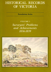
Book, Michael Cannon, Historical records of Victoria : foundation series : volume 5 : surveyors? problems and achievements 1836-1839, 1988
Reproductions of various transactions and reports dealing with the surveying history of Port Phillip, including letters, maps, illustrations, tables, and a detailed history of the surveying of Victoria.maps, b&w illustrations, b&w photographs, tablesvictorian history, port phillip, robert hoddle, monee monee creek, geelong, barwon river, werribee river -
 Peterborough History Group
Document - Maps, tourist information
Council boundaries, past tourist information, past mapsHistoric town information and mapsPhotocopies, copies of maps, newspaper clippingpeterborough history, peterborough 3270 -
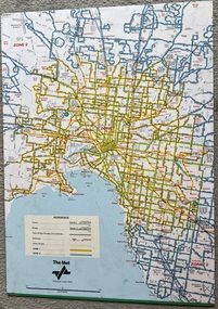
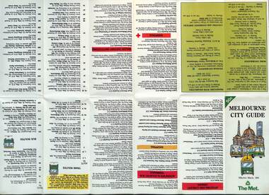 Melbourne Tram Museum
Map, The Met, "Melbourne City Guide", March 1991
... maps ...Map issued by The Met, March 1991 based on a Melway map of the Central city area providing details of tram, bus and trains, attractions, major institutions, tourism information, and dining out areas or streets. Demonstrates a map produced by The Met to assist Melbourne visitors.Map - 14 fold printed on gloss paper.trams, tramways, the met, maps, melbourne, cbd -
 Eltham District Historical Society Inc
Book, Melway Publishing, Melway Greater Melbourne street directory : including Geelong, Phillip Island, Healesville, Bellarine & Mornington Peninsulas, 2002
... maps ...Edition 29. Coloured detailed maps accessed by a street or location index. Cover: 20 additional pages of new maps, extended coverage of Bellarine Peninsula, further coverage of Werribee South, Public Transport Information, latest official suburb boundaries, CBD "hook turn" intersections map, over 1200 new streets, 1 atlas (24, 886 p.) : col. maps ; ISSN 03113957streets, roads, melbourne, maps, melway -
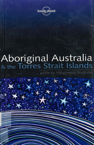 Victorian Aboriginal Corporation for Languages
Book, Sarina Singh, Aboriginal Australia & the Torres Strait Islands : guide to Indigenous Australia, 2001
Comprehensive text with maps, coloured photos etc., dealing with all of Indigenous Australia. Provides historical references. Details of the Mabo finding.maps, b&w photographs, colour photographs, illustrations, word listsculture, travel guide, tourism, art, food -
 City of Kingston
Pamphlet - Colour, S. M. Reynolds, Estate Agent, Moorabbin Shire Hall Estate Second Section, c. 1930
Sales plan for land in the suburb of Moorabbin, bounded by South Road and Highbury Street, including Prince Street, Charming Street, Thomas Avenue and Keith Road.The developing urban area of Moorabbin within the City of Kingston. This land sale pamphlet illustrates the subdivision of land within the municipality and the changing demographic of the district as new houses are constructed close to infrastructure.Colour pamphlet advertising for private sale the Moorabbin Shire Hall Estate, Moorabbin. Incorporates a map of the estate bordered by South Road and Highbury Street, including Prince Street, Charming Street, Keith Road and Thomas Avenue.Handwritten in grey pencil on subdivision map below subdivision 63: £4 Handwritten in grey pencil on subdivision map below subdivision 66: 4 Handwritten in grey pencil on subdivision map below subdivision 80: 3. Handwritten in grey pencil on subdivision map below subdivision 81: 4 Handwritten in grey pencil on subdivision map below subdivision 83: 2 Handwritten in grey pencil on subdivision map below subdivision 96: £3 Handwritten in grey pencil on subdivision map below subdivision 97: 3 Handwritten in grey pencil on subdivision map to the left of subdivision 102: 3 Handwritten in grey pencil on subdivision map on the corner of Thomas Avenue and Highbury Street: vertical line next to a square with a cross in it.land sales, estate, moorabbin -
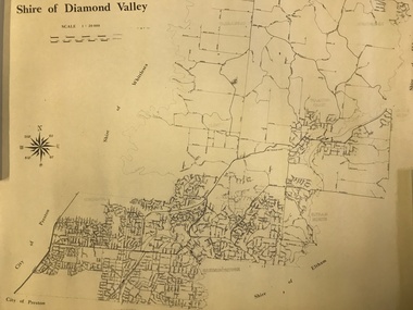 Greensborough Historical Society
Map, Shire of Diamond Valley, 1964-1994
Map of the former Shire of Diamond Valley, 1964-1994, showing the local government area from Greensborough to Hurstbridge.Map on yellowed paper.shire of diamond valley, greensborough, hurstbridge -
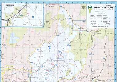 Greensborough Historical Society
Map, Shire of Eltham, 1990c
1:20000 map of Shire of Eltham, with enlargements of a number of areas.Colour map, printed both sides.shire of eltham, eltham -
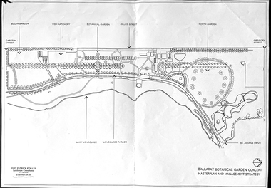 Friends of Ballarat Botanical Gardens History Group
Work on paper - Ballarat Botanical Garden Concept, Masterplan and Management Strategy, Unknown
... Maps ...This map is important in terms of the planning and management of the Ballarat Botanic Gardens The Map adds to our understanding and knowledge of the history of the Ballarat Botanical Gardens 1 page of a map in black and white. the number 44 is circled in pencil on the top righthand corner of the back of the page.john garner, doctor, john garner collection, ballarat botanic gardens, maps, masterplan, management strategy, john patrick, landscape consultants, ballarat city council, friends of ballarat botanical gardens, gardens, ballarat -
 Victorian Aboriginal Corporation for Languages
Book, Ian D Clark et al, Stonnington's Indigenous history, 2006
This document is a summary of 'An indigenous history of Stonnington (2006) by Dr Ian Clark and Laura Kostanski, University of Ballarat.maps, b&w illustrations, b&w photographs, colour illustrations, word listswoiwurrung, woi wurrung, boonwurrung, boon wurrung, eastern kulin, derrimut, george augustus robinson, george langhorne, helen baillie, banjo clarke, jim berg, stonnington, william thomas, coranderrk, local history, victorian history, -
 Federation University Historical Collection
Photograph - coloured, Department of Lands and Survey, Portion of Victoria showing auriferous areas and mineral localities, 1935, 1935
Map included with book "Victoria: Gold and Minerals" issued by Mines Department Victoria, 1935Fold out coloured mapYellow mark indicating depositsvictoria, auriferous areas, mineral localities, department of mines, tin, antimony, copper, silver lead, tungsten, manganese, platinum, iron -
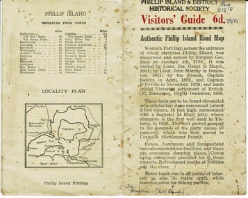 Phillip Island and District Historical Society Inc.
Booklet, Authentic Phillip Island Road Map, Pre 1960
Tourist brochure printed by the Phillip Island Printers pre 1960HistoricalSmall cream coloured brochure with details of accommodation, transport and animals. Inside is a map of the Island with numbered points of interest. There is also a plan of Cowes and drawings of animals.Visitors' Guide 6d Authentic Phillip Island Road Maptourist brochure, road map -
 Melbourne Tram Museum
Document - Informaion booklet / folder, The Met, "The Met", late 1980s
Information document about The Met, its services, forward plans, trams, trains, buses. Includes maps showing where upgrades were planned, including roads, and electrification of rail lines. Has a forward by Kevin Shea the Managing Director of The Met. Undated, late 1980s, based on the text with some dates. Has a photo of B2 class tram No. 2005. Notes the completion of the Hong Kong project in 1988.Provides infomation about the forward planning of The Met in late 1980s.Document - 16 pages including folded out sheet + card covers.melbourne, tramways, trams, the met, mta, railways, buses, planning -
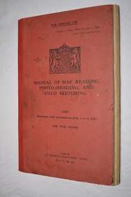 Wangaratta RSL Sub Branch
Book, Manual of Map Reading Photo Reading and Field Sketching, 1948
Official copy of War Office Manual of Map Reading Photo Reading and Field Sketching.Red bound book with black writing and British crest.Manual of Map Reading Photo Reading and Field Sketching 1929 The War Officemanual of map reading photo reading and field sketching., war office -
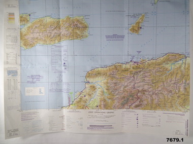 Bendigo Military Museum
Map - MAPS, EAST TIMOR, US Govt et al, 1975 - 1976
... Maps ...1. This is a coloured map. It's scale is 1.250,000 - called a jpoint operations graphic. It covers the North side of East Timor. Dili is in the centre. Its shows 4 Islands to the north of Timor. It shows Savu Fea, Ombai Strait, Wetar Strait. On bottom left of map it shows Batheade and the start of the New Border. Map - Series 159. Sheet 5C- 51-4. Edition 3-GSGS. 2. This is a coloured map. Its scale is 1.250,000 called a joint Operations Graphic. It manly covers West Timor. It shows Savu Sea in North and Timor Sea on south side. Series 1501. Sheet SC 51.7. Edition 3-GSGS. 3. This a coloured map. It's scale is 1.250,000. Joint operations graphic. This map shows the south side of East Timor and the Timor Sea. This map shows a highlighted New border. The major towns on South coast are KAMFNASA, BETANO. Map series 1501. Sheet SC 51-8. Edition 3 GSGS.1. Has highlighted "7 BSG" on coast. All maps show East Timor border highlighted in pink.east timor, maps, interfet -
National Vietnam Veterans Museum (NVVM)
Memorabilia, Memorabilia of Neil Ernest Swainston
Contains photocopies of his Army documents & 6 microfiche of contour maps (?)vietnam war, 1961-1975 - personal narratives - australian -
 Heidelberg Golf Club
Book, Melbourne Parks and Waterways, Lower Plenty River concept plan: Maroondah Pipe Track to Yarra River, 1994
Lower Plenty River concept plan: Maroondah Pipe Track to Yarra River. Includes suggestion of Plenty River Trail along the west boundary of the Heidelberg Golf Club.66 p., illus., colour map. Also, Draft copy of document.plenty river trail, lower plenty river, heidelberg golf club, mmbw, melbourne parks and waterways -
 Melbourne Tram Museum
Map, The Met, "Tram and bus Routes showing destination numbers", June 1992
Titled "Tram Routes showing destination numbers". Map dated June 1992 and has been printed with The Met logo. Shows routes with route numbers, names of main destinations, roads, railway stations and rail lines, rivers, scales and Zones. Does not have the CBD insert. Same size as that of item 1099, a 1972 version. Type of map that was placed on the rear of the driver's doors of a W Class tramcar.Demonstrates a The Met produced map used in trramcars.Full colour map or poster printed on paper trimmed from original map and mounted on cardboard.Has some pen marks in the bottom left hand corner.trams, tramways, map, routes, the met -
Stawell Historical Society Inc
Map - Electoral Map, Federal Government, map of Commonwealth Electoral Division of Wimmera 1949, 1949
Electoral MapMap overprinted with Electoral Divisions in Red. Description of Division of Wimmera Scale in Miles. Commonwealth of Australia State of Victoriagovernment -
 Lara RSL Sub Branch
Map, Framed Map of the western front 1914-1918, Map made by G.F.Trudgion R.A.E. circa 1916
Map showing position of western front line in 1914 at the start of WW1Map is from circa 1916 showing battle area of the Western Front during WW1Map of the western front 1914-1918North West Europe Shewing the Western Front 1914-1918 War. Below is description of Australian ANZAC's on Western Front and a graph on Comparison of Casualties from Major Western Front Battlesmap, g.f.trudgion, r.a.e., western front, ww1, world war one, north west europe, 1914, 1916, ww1 casulaties -
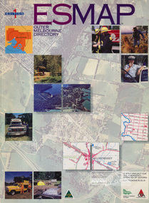 Eltham District Historical Society Inc
Book, Country Fire Authority Mapping Association Inc, ESMAP - Outer Melbourne Directory, 1991
Outer Melbourne directory of information for emergencies with maps of the state and major towns217 p. : maps ; 30 cm.ISBN 0646065661emergency services victoria -
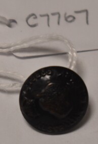 Tatura Irrigation & Wartime Camps Museum
Button, P J King Pty Ltd
Issued to Sister Kathleen Heaphy of Australian Army Nursing service. Sister Heaphy was attached, for part of her service, to 28 Camp Hospital Internment camp 1.round brass button with a metal shank. Crown and map of Australia and wording around the circumference.Australian Military Forces A crown and map of Australia P. J. King Pty Ltd Melbaustralian army nursing service, sister kathleen heaphy, 28 camp hospital internment camp 1 -
 Greensborough Historical Society
Pamphlet, Lower Plenty Shopping Centre, 2007
Coloured pamphlet from Lower Plenty Shopping Centre with list of shops, map and 2008 CalendarColour pamphlet with calendar and maplower plenty shopping centre, calendars, lower plenty -
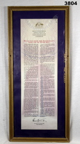 Bendigo Military Museum
Document - DOCUMENT, FRAMED, C. 1993
Document of a speech by the Prime Minister of Australia, The Hon P J Keating MP at the funeral service of the unknown Australian soldier on 11.11.1993. Document is printed on cream background with coat of arms at top. Mounted with purple border & gold wooden frame with glass front & wooden ply backing.Top of document in red print: “We do not know this Australian's name and we never will” Bottom L: “Signature of the Prime Minister of Australia”document, framed, unknown soldier -
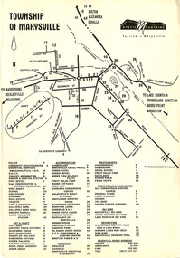 Marysville & District Historical Society
Flyer (Item) - Town map, Mystic Mountains Tourism, TOWNSHIP OF MARYSVILLE, Unknown
A map of the township of Marysville published by Mystic Mountains Tourism in Marysville. The map shows a legend of various services, accommodation sites, shops restaurants and recreation spots in the township.A map of the township of Marysville published by Mystic Mountains Tourism in Marysville.marysville, victoria, australia, mystic mountains tourism, map