Showing 3561 items matching "environments"
-
 Kiewa Valley Historical Society
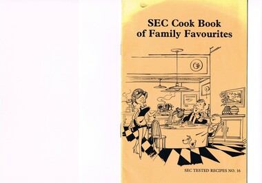
Book - Reference Cooking, SEC Cook Book of Family Favourites, Circa 1950
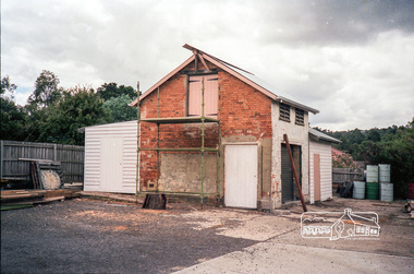
This SEC cook book was produced circa 1950s when the Kiewa Hydro Electricity Scheme and its Commission was in full swing. The Commission had constructed two settlements, Mount Beauty and Bogong Village to house construction workers and their families in a "closed" community. These "closed" communities were for SEC staff and construction workers only. Entry into these villages was restricted to "SEC pass" carrying construction staff and their families. All facilities such as retail, sporting and other community services was provided by the SEC. This created an isolated community in which limited individual choice or administrative family leeway was available. It was a typical company town (live and work for the company). The Company was in the Kiewa Valley constructing power stations for the Kiewa Hydro Electricity Scheme of Victoria. In one way the individual did not need to be concerned with living costs, educational needs for children, and recreational amenities and therefore "normal" community survival /living methods did not apply. This living, although restrictive, was quite simple. When the scheme was completed, in 1961, marking the end of company town, caused some of the employees, who had enjoyed the "controlled" township environment, a fair degree of angst in having the new 'laissez-faire" controls thrust upon them. This was magnified when both Mount Beauty and Bogong Village became meshed into the Bright Shire, vis-a-vis, local government. This cook book is a prime example of " the company is looking after you" and leave the worrying to us. This environment of a "company town", which creates the atmosphere of minimal personal responsibilities, is still present in a few remote mining towns in Australia at the beginning of the 21st Century.This book is a classical example of the psychological control in which the company had its construction workers families living in. The motto of many companies who had employees in isolated regions was "keep them happy". A happy and contented worker is a more productive worker. This was a period in time (1950s to 1970s) when social psychology was gaining recognition in the Australian workforce as well as internationally. At the end of the construction of all the power stations both the Mount Beauty settlement and the Bogong Village became more integrated into the main stream of rural Australia environment. Development of tourism in the region opened up not only interaction with a greater cross section of the ever expanding type of Australian but also the overseas based non rural culture tourist or immigrant. It allowed the intermingling of ideas in a non company controlled environment. The Mount Beauty and Bogong Village has, and even up to the 3000 Millennium, the same housing construction, as was built by the SEC. There has only been a very gradual change to modern domestic architectural home styles. This SEC cookbook has a folded cover with two staples at the spine, securing eight double sided pages. The white pages contain black print and sketches(3), and one black and white photograph (of the author). The front cover is mainly orange in colour with a gradual fading into yellow(at the top). The cover is approximately 210 g/m2 in thickness and each page is approximately 90 g/m2 thick. Front cover: top of page "SEC Cook Book of Family Favourites", in the middle a sketch, black on orange background, of a smiling mother walking from the kitchen to the dining table with a steaming rolled roast and vegetables in one hand and a gravy pot in the other. The furniture and decor relates to the 1950s. Below this sketch is printed"SEC TESTED RECIPES NO. 16" Inside cover: on top of the page is a black and white sketch of a pineapple, apple pear fish with scales, bunch of grapes with leaves a pork roll (head of pig one end and a roll ending on the other, on top of this food arrangement rests a fruit pie. Below this sketch are printed in black print the books contents.The first side of the first page is a black and white photograph Mary Dunne, the SEC Home Service supervisor who provided a signed foreword. The inside back cover has a promotional segment detailing a black and white photograph of a smiling (and happy) couple in the foreground with an electric stove in the distance. The written motto below this photograph is" to Live better -and save money they'll join the Power People. "the new tariff is(1960s) - First 75kWh --6 cents per kWh Next 435 kWh---2.3 cents per kWh Balance --1.7 cents per kWh The rate per killowatt-hour for the final block drops from 2.1 cents to 1.7 cents --a reduction of 19%.cooking recipes circa 1950s, domestic food, sec victoria cook books, recipes circa 1950s -
 The Beechworth Burke Museum
Geological specimen - Precious Opal
In Australia, precious opal is found in Cretaceous age sandstones and mudstones. These sedimentary rocks were deeply weathered and this weathering released silica into the groundwater.Australia is the only part of the world where opalised animal and plant fossils have been found. Opal artefacts several thousands of years old have been discovered in East Africa. As early as 250 BC the Romans prized opals, thought to have come from mines in Eastern Europe, the ancient world's main source of opals. There are many aboriginal dreamtime stories that feature opal. Australian opals discovered during the late 1800's found little favour with European markets but their commercial value increased in the 1900's and in 1932 Australia took over as the major producer of opals in the world and remains the largest producer to this day. Opal is found around the world (Brazil, Mexico, Honduras and the western US) however Australia produces 95% of the world's precious opal and it is our official national gemstone. Opal was first mined commercially at Listowel Downs in Queensland in 1875 and later at White Cliffs in NSW. Today, Coober Pedy (SA) is the main producer of white opal, though in recent years this field has expanded and all types of opals are found. Other centres in SA include Andamooka and Mintabe. Lightning Ridge (NSW) is renowned for black opal and formerly White Cliffs was a large producer of high quality opal. Boulder opals (opals in concretionary ironstone) are mined in Queensland from numerous localities in a zone extending from the Eulo and Cunnamulla district in the south and northwest for a distance of over 700 km to Kynuna in the north. The towns of Quilpie, Yowah and Winton are the main opal mining and wholesale centres. Opals are considered gemstones and have been used in jewellery for thousands of years.Throughout much of history, opals were actually believed to be good luck. The Romans thought that opals were one of the luckiest gemstones and a symbol of hope. In the Middle Ages, opals were believed to be bestowed with all the positive properties of coloured gemstones due to its rainbow-like play of colour. Finally, there is a superstition that you should not wear an opal unless it is your birthstone otherwise misfortune will befall you. This, of course, is far-fetched, but the notion could have been promoted in the late 19th and early 20th Centuries by diamond traders who were trying to increase sales of diamonds and deter people from buying opals. Possibly related to this is the thought that you should set opal jewellery with diamonds as their powers of good fortune will override any negativity held by the opal. The great majority of opal does not show play of colour and is called common opal or potch however this is not the case with a precious opal. Opal is a precious gemstone, like rubies, emeralds or diamonds. Opal is rare, and it is expensive to prospect and mine for.Silica is one of the most common minerals on the planet, but precious opal is very rare – far more rare than diamonds. Precious opal is rare because the natural processes that create it rarely occur.Most (at least 95%) of the opal found by miners is common opal without gem colour. In Australia we call it potch. It can be white, grey, black or amber coloured. Even when a miner finds gem-coloured opal, most of it can’t be cut into gemstones because it’s too thin, or sandy. This specimen is part of a larger collection of geological and mineral specimens collected from around Australia (and some parts of the world) and donated to the Burke Museum between 1868-1880. A large percentage of these specimens were collected in Victoria as part of the Geological Survey of Victoria that begun in 1852 (in response to the Gold Rush) to study and map the geology of Victoria. Collecting geological specimens was an important part of mapping and understanding the scientific makeup of the earth. Many of these specimens were sent to research and collecting organisations across Australia, including the Burke Museum, to educate and encourage further study.It is not known where this opal originated, except that it is probably from Victoria, as it has been recorded from many localities in the State. Common Opal is formed from silica-rich water circulating through rocks near the Earth’s surface. It consists of minute spheres of silica arranged in different ways. In common opal, the spheres are of different sizes and randomly arranged, unlike in precious opal where the spheres are of similar size and uniformly arranged in three dimensions. These differences account for common opal generally being translucent to opaque and without the play of colours, or opalescence, displayed by precious opal. Common opal is found in many localities and different geological environments throughout Australia and the world. Precious opal requires special conditions to form and is much less common. Australia produces most to the world’s precious opal. burke museum, beechworth, indigo shire, beechworth museum, geological, geological specimen, precious opal, opal, brazil, mexico, honduras, queensland, coober pedy, gemstones, jewellery, play-of-colour, light blue -
 Bendigo Historical Society Inc.
Document - FOSTERVILLE GOLD MINE COLLECTION: OPEN DAY 2019
Two page document for Kirkland Lake Gold Open day 2019. Open Day activities include: bus tours, technical services display, geology, exploration, processing, community and environment display, minerals council of Australia, Swick drilling, Central Deborah Gold Mine, Face painting, Goldfields Re-vegetation, Delecca's hire equipment, MacMahon underground mining services, Sandvik, and ISH24 safety specialists. Map of 'Fosterville Gold Mine Site Map' with activities highlighted. Fosterville is Victoria's larges gold producer and in 2918 a records 356,230 ounces at an average grade of 24.9 g per tonne. The mine has over 600 full time employees in 2019. Entry for '9 levels of darkness' tour at Central Deborah Mine attached.bendigo, mining, fosterville gold mine -
 Bendigo Historical Society Inc.
Document - LA TROBE UNIVERSITY ANNUAL PRESENTATION OF AWARDS & PRIZES FOR THE YEAR 2001
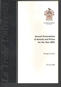
Booklet titled La Trobe University Australia Annual Presentation of Awards and Prizes for the Year 2001. Bendigo Campus. Date on the front cover 23 July 2002. Cover is cream and black. In the front is a Message from the Vice-Chancellor, Professor Michael J. Osborne. Photo of La Trobe University, Bundoora campus. Also in the booklet is the Order of Proceedings, Prize Winners 2001 - School Awards, Prize Winners 2001 - School of Arts and Education, School of Business and Technology, School of Health and Environment, Faculty Awards, University Awards, Scholarships for 2002 and Staff Excellence in Teaching Awards 2001. There is also information of The Armorial Bearings, The Mace and The Origins of the Academic Dress, Colors of Academic Regalia at La Trobe University, The D. M. Myers University Medal and Charles Joseph La Trobe.education, bendigo, la trobe university bendigo campus, la trobe university annual presentation of awards & prizes for the year 2001, professor michael j osborne, charles joseph la trobe -
 Melbourne Tram Museum
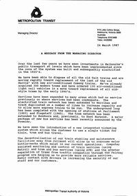
Document - Notice, The Met, "MTA Business Planning Report No. 1 - Analysis of the Existing situation", 24/03/1987 12:00:00 AM
Set of two A4 documents about the future and current situation or status of the Metropolitan Transit Authority of Victoria (The Met). .1 - A3 folded sheet, titled "A message from the Managing Director" signed by Kevin Shea, dated 24/3/1987 setting out the current situation, changes, services, Jolimont, new tram lines, ticketing, vehicles and future planning. Business Plan released the same day by the Minister Tom Roper. .2 - 12 A4 pages - centre stapled printed on orange paper, titled "MTA Business Planning Report No. 1 - Analysis of the Existing situation" - setting out the policy context, goals and objectives, international perspective, patronage and service levels, fares system, human resources, capital investment, financial performance, changing environment, key issues and next stepstrams, tramways, the met, planning, reports, finances, railways, new trams, new track -
 Eltham District Historical Society Inc
Film - Video (DVD), Nillumbik Shire Council, Edendale Farm Community Environment Centre: History, c.2009
EDENDALE FARM Edendale Farm is Nillumbik Shire Council's environment centre situated in Gastons Road, Eltham between the railway and the Diamond Creek. The homestead on the property was built in 1896 and is of historical significance, being the subject of a Heritage Overlay under the Nillumbik Planning Scheme. The Edendale property was originally part of an extensive land purchase in 1852 from the Crown by pioneer Eltham farmer Henry Stooke. He initially purchased 51 acres and later expanded his holdings by purchasing another three adjacent Crown allotments extending northerly from Josiah Holloway's Little Eltham subdivision. Despite clearing the land, Stooke did not build on this property, choosing to live on his property "Rosehill" at Lower Plenty. In 1896 Thomas Cool, Club Manager of the Victoria Coffee Palace in Melbourne purchased 7 acres of the original Stooke land and built the house now known as Edendale. Cool did not farm the land, instead using it as a gentleman’s residence, retiring to Eltham at weekends. In 1918 he purchased an additional 7 acres but in 1919 he sold the property. Later owners included J.W. Cox, the Gaston family and D. Mummery. In the 1980s the Eltham Shire Council purchased the site for use as a Council depot, but this use did not proceed. Subsequently, it was used as the Council pound. The Edendale Farm Pet Education and Retention Centre was established in the summer of 1988/1989 and was set up to replace the existing dog kennels with a high standard pet retention centre. The design style of the building was established to compliment the features of the existing house. It was equipped with 10 retention pens, a veterinary room and a pet education area where school children and other interested parties learnt about pet care procedures. It was later developed into a community farm and was run by an advisory committee and in 2000 it became an Environment Centre. In early 2006 an advisory committee was established for the development of a master plan for future development at Edendale Farm. The committee included Russell Yeoman, a former long-time shire planner and founding member of the Eltham District Historical Society. At the time of filming the Master Plan and future for Edendale was about continuing to develop Edendale as a centre of environment learning and looking at expanding displays and school program, running a lot more of life-long learning and workshops around sustainable living.edendale community farm, eltham, gastons homestead, gastons road, shire of nillumbik, video recording -
 Kiewa Valley Historical Society
Postcard Circa 1950, Snow Plough, Bogong High Plain,5,500 Feet Kiewa Hydro-Electric Project, Circa 1950
This postcard was produced in the 1950's for the tourist trade in the Kiewa Valley and Alpine region. It encompasses the period when the State of Victoria was pressured by the ever increasing demand by industry and its population for electricity supplies. Hydro electricity was seen as an untapped natural resource to quench this demand. The Victorian Alps and the rivers flowing into its valleys was ideal for the construction of the Kiewa Hydro Electricity Scheme. The late 1940's saw the development of this scheme and the changing of sections of alpine landscape is covered by this and other postcards/pictures (tourists, construction workers, and established rural populations). This period in time was before the established wildlife and forest/nature groups became political activist who changed legislative acts to protect the environment. This rural region (Kiewa Valley/alpine plains) was at most only significant to a smaller group of winter sports, summer hikers/horse riders and rural farmers/graziers. The numbers of tourists and the increase in the local resident population was boosted by the construction of the Hydro Electricity Scheme. This influx to the regional population resulted in a corresponding diversity in services and brought about an environment that responded to a growing level of tourists and thereby permitting this industry to grow more rapidly than it would have naturally. This postcard details an attraction to the "cleaner" method of providing electricity. This postcard was purchased in 1950 by a surveyor at Landford's Gap. This item is a black and white photograph(professional) of a panoramic view of a snow plough clearing the unsealed road in 1950.This postcard is on quality paper and the reproduction of the picture is of a high standard.For other "tourist" postcards see 0480 (A) -(F) for other photos of similar postcards. kiewa valley tourism, victorian alps, alternate energy supplies, alpine population growth, secv, snow plough -
 Kiewa Valley Historical Society
Postcard Circa 1950, Road to Bogong High Plains Kiewa Hydro Electric Project, Circa 1950's
This postcard was produced in the 1950's for the tourist trade in the Kiewa Valley and Alpine region. It encompasses the period when the State of Victoria was pressured by the ever increasing demand by industry and its population for electricity supplies. Hydro electricity was seen as an untapped natural resource to quench this demand. The Victorian Alps and the rivers flowing into its valleys was ideal for the construction of the Kiewa Hydro Electricity Scheme. The late 1940's saw the development of this scheme and the changing of sections of alpine landscape is covered by this and other postcards/pictures (tourists, construction workers, and established rural populations). This period in time was before the established wildlife and forest/nature groups became political activist who changed legislative acts to protect the environment.This rural region (Kiewa Valley/alpine plains) was at most only significant to a smaller group of winter sports, summer hikers/horse riders and rural farmers/graziers. The numbers of tourists and the increase in the local resident population was boosted by the construction of the Hydro Electricity Scheme. This influx to the regional population resulted in a corresponding diversity in services and brought about an environment that responded to a growing level of tourists and thereby permitting this industry to grow more rapidly than it would have naturally. This postcard details an attraction to the "cleaner" method of providing electricity. This postcard was purchased in 1950 by a surveyor at Landford's Gap.This black and white photograph on a Valentine's postcard is from a V2 Argus photograph.. It is on a 200g/m paper density photo side gloss. See 0480 (A) - (G) for other photos of similar postcards.In white lettering " ROAD TO BOGONG HIGH PLAINS KIEWA HYDRO-ELECTRIC PROJECT", V3secv, road making, victorian alps -
 Kiewa Valley Historical Society
Postcard - Rocky Valley - Circa 1950, 1950
This postcard was produced in the 1950's for the tourist trade in the Kiewa Valley and Alpine region. It encompasses the period when the State of Victoria was pressured by the ever increasing demand by industry and its population for electricity supplies. Hydro electricity was seen as an untapped natural resource to quench this demand. The Victorian Alps and the rivers flowing into its valleys was ideal for the construction of the Kiewa Hydro Electricity Scheme. The late 1940's saw the development of this scheme and the changing of sections of alpine landscape is covered by this and other postcards/pictures (tourists, construction workers, and established rural populations). This period in time was before the established wildlife and forest/nature groups became political activist who changed legislative acts to protect the environment.This rural region (Kiewa Valley/alpine plains) was at most only significant to a smaller group of winter sports, summer hikers/horse riders and rural farmers/graziers. The numbers of tourists and the increase in the local resident population was boosted by the construction of the Hydro Electricity Scheme. This influx to the regional population resulted in a corresponding diversity in services and brought about an environment that responded to a growing level of tourists and thereby permitting this industry to grow more rapidly than it would have naturally. This postcard details an attraction to the "cleaner" method of providing electricity. This postcard was purchased in 1950 by a surveyor at Landford's Gap.This black and white photograph is from a Valentine's V2 Argus postcard. It is on a 200g/m paper density one side gloss. See also KVHS 0480 (A) to (L) for similar postcards. "ROCKY VALLEY FROM BOGONG HIGH PLAINS KIEWA HYDRO-ELECTRIC PROJECT" "V1"kiewa valley tourism, victorian alps, alternate energy supplies, alpine population growth, rocky valley, secv -
 Kiewa Valley Historical Society
Postcard - Junction Dam - Circa 1950, Circa 1950's
This postcard was produced in the 1950's for the tourist trade in the Kiewa Valley and Alpine region. It encompasses the period when the State of Victoria was pressured by the ever increasing demand by industry and its population for electricity supplies. Hydro electricity was seen as an untapped natural resource to quench this demand. The Victorian Alps and the rivers flowing into its valleys was ideal for the construction of the Kiewa Hydro Electricity Scheme. The late 1940's saw the development of this scheme and the changing of sections of alpine landscape is covered by this and other postcards/pictures (tourists, construction workers, and established rural populations). This period in time was before the established wildlife and forest/nature groups became political activist who changed legislative acts to protect the environment.This rural region (Kiewa Valley/alpine plains) was at most only significant to a smaller group of winter sports, summer hikers/horse riders and rural farmers/graziers. The numbers of tourists and the increase in the local resident population was boosted by the construction of the Hydro Electricity Scheme. This influx to the regional population resulted in a corresponding diversity in services and brought about an environment that responded to a growing level of tourists and thereby permitting this industry to grow more rapidly than it would have naturally. This postcard details an attraction to the "cleaner" method of providing electricity. This postcard was purchased in 1950 by a surveyor at Landford's Gap.This black and white photograph is a Valentine's postcard, from a V2 Argus photograph. It is on a 200g/m paper density with only the photo side gloss.Front "JUNCTION DAM & SPILLWAY, BOGONG KIEWA HYDRO-ELECTRIC PROJECT" on the flip side "VALENTINE'S POST CARD " "A GENUINE PHOTOGRAPH"kiewa valley tourism, victorian alps, alternate energy supplies, alpine population growth, junction dam, secv -
 Kiewa Valley Historical Society
Postcard - Junction Dam - Circa 1950, Circa 1950
This postcard was produced in the 1950's for the tourist trade in the Kiewa Valley and Alpine region. It encompasses the period when the State of Victoria was pressured by the ever increasing demand by industry and its population for electricity supplies. Hydro electricity was seen as an untapped natural resource to quench this demand. The Victorian Alps and the rivers flowing into its valleys was ideal for the construction of the Kiewa Hydro Electricity Scheme. The late 1940's saw the development of this scheme and the changing of sections of alpine landscape is covered by this and other postcards/pictures (tourists, construction workers, and established rural populations). This period in time was before the established wildlife and forest/nature groups became political activist who changed legislative acts to protect the environment.This rural region (Kiewa Valley/alpine plains) was at most only significant to a smaller group of winter sports, summer hikers/horse riders and rural farmers/graziers. The numbers of tourists and the increase in the local resident population was boosted by the construction of the Hydro Electricity Scheme. This influx to the regional population resulted in a corresponding diversity in services and brought about an environment that responded to a growing level of tourists and thereby permitting this industry to grow more rapidly than it would have naturally. This postcard details an attraction to the "cleaner" method of providing electricity. This postcard was purchased in 1950 by a surveyor at Landford's Gap.This black and white photograph on a Valentine's postcard is from a V2 Argus photograph. It is on a 200g/m paper density one side gloss only/. See 0480 (A) -(L) for other photos of similar postcards."JUNCTION DAM & SPILLWAY, LAKE GUY, BOGONG, KIEWA HYDRO-ELECTRIC PROJECT" "V5" on the flip side" VALENTINE'S POST CARD " "A GENUINE PHOTOGRAPH"kiewa valley tourism, victorian alps, alternate energy supplies, alpine population growth, junction dam, secv -
 Kiewa Valley Historical Society
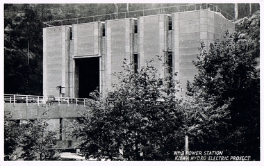
Postcard Circa 1950, No.3 Power Station Kiewa Hydro-electric Project "V.8", Circa 1950
This postcard was produced in the 1950's for the tourist trade in the Kiewa Valley and Alpine region. It encompasses the period when the State of Victoria was pressured by the ever increasing demand by industry and its population for electricity supplies. Hydro electricity was seen as an untapped natural resource to quench this demand. The Victorian Alps and the rivers flowing into its valleys was ideal for the construction of the Kiewa Hydro Electricity Scheme. The late 1940's saw the development of this scheme and the changing of sections of alpine landscape is covered by this and other postcards/pictures (tourists, construction workers, and established rural populations). This period in time was before the established wildlife and forest/nature groups became political activist who changed legislative acts to protect the environment.This rural region (Kiewa Valley/alpine plains) was at most only significant to a smaller group of winter sports, summer hikers/horse riders and rural farmers/graziers. The numbers of tourists and the increase in the local resident population was boosted by the construction of the Hydro Electricity Scheme. This influx to the regional population resulted in a corresponding diversity in services and brought about an environment that responded to a growing level of tourists and thereby permitting this industry to grow more rapidly than it would have naturally. This postcard details an attraction to the "cleaner" method of providing electricity. This postcard was purchased in 1950 by a surveyor at Landford's Gap.This black and white photograph from a Valentine's postcard is from a V2 Argus photograph postcard. It is on a 200g/m paper density photo side gloss. See 0480 (A) - (K) for other photos of similar postcards."No.3 POWER STATION KIEWA HYDRO ELECTRIC PROJECT" "V8"kiewa valley tourism, victorian alps, alternate energy supplies, alpine population growth, secv -
 Glen Eira Historical Society
Article - Alnwick, Railway Parade,|11-11A,|Murrumbeena
Letters and research material regarding ‘Alnwick’, 11-11A Railway Parade, Murrumbeena. First two letters were sent by Fay Johnson to Dr. C. Kellaway at the ministry for planning and environment on 16/06/1988 and 10/08/1988. The latter includes research material regarding the ‘ALNWICK’ house including a brief description of the history of Sir James Patterson, photos of the house and a newspaper extract regarding its sale. The other letters were sent to the secretary of Caulfield Historical Society from the Historic Buildings Council inviting them to attend a hearing about ‘Alnwick’s’ classification. Almost identical letters, they were sent on 30/09/1988 and 07/02/1989.kellaway carlotta, johnson fay, kaeppel rose, kaeppel a. j., caulfield shire council, register of historic buildings, railway parade, shire of caulfield rate book, murrumbeena cres, anzac street, murrumbeena road, murrumbeena station, margaret street, caulfield historical society, historic buildings council, classification, historic buildings, historical societies, local history, dandenong road, fitzroy street, spencer david, ford hazel, patterson james sir, patterson james, burrough naomi, walton anna, murrumbeena, carnegie, politician, parliamentary representatives, slaughterman -
 Eltham District Historical Society Inc
Photograph, The former Police residence at 728 Main Road under renovation work for future Shire of Eltham use, c.Nov. 1991
The original Eltham Police Station was used up till about 1960. The building was then taken over and used by the Vermin and Noxious weeds Destruction Section of the Department of Crown Lands and Survey. They vacated the building c.March 1981 and it remained unoccupied for a period of time whilst its future was discussed in Council. About 1986 the Shire took over use of the Police Residence and renovated it for use by the Shire Parks and Environment Office. The original Police Station was termite infested and was removed. It was later replaced by a replica building which was used as a lunchroom for Council employees working at the site. Based on photos contained in the 1992 Bick Heritage Study of the Police Residence and Stable, this roll of film was taken Nov 1991.Roll of 35mm colour negative film, 7 stripsKodak GA 100 5095shire of eltham, justice precinct, police residence, police station, local history centre -
 Eltham District Historical Society Inc
Photograph, The original Police Stables at 728 Main Road under renovation work for future Shire of Eltham use, c.Nov. 1991
The original Eltham Police Station was used up till about 1960. The building was then taken over and used by the Vermin and Noxious weeds Destruction Section of the Department of Crown Lands and Survey. They vacated the building c.March 1981 and it remained unoccupied for a period of time whilst its future was discussed in Council. About 1986 the Shire took over use of the Police Residence and renovated it for use by the Shire Parks and Environment Office. The original Police Station was termite infested and was removed. It was later replaced by a replica building which was used as a lunchroom for Council employees working at the site. Based on photos contained in the 1992 Bick Heritage Study of the Police Residence and Stable, this roll of film was taken Nov 1991.Roll of 35mm colour negative film, 7 stripsKodak GA 100 5095shire of eltham, justice precinct, police residence, police station, local history centre -
 Kiewa Valley Historical Society
Postcard Circa 1950, Lake Guy Dam and Bogong Village, Circa 1950
This postcard was produced in the 1950's for the tourist trade in the Kiewa Valley and Alpine region. It encompasses the period when the State of Victoria was pressured by the ever increasing demand by industry and its population for electricity supplies. Hydro electricity was seen as an untapped natural resource to quench this demand. The Victorian Alps and the rivers flowing into its valleys was ideal for the construction of the Kiewa Hydro Electricity Scheme. The late 1940's saw the development of this scheme and the changing of sections of alpine landscape is covered by this and other postcards/pictures (tourists, construction workers, and established rural populations). This period in time was before the established wildlife and forest/nature groups became political activist who changed legislative acts to protect the environment.This rural region (Kiewa Valley/alpine plains) was at most only significant to a smaller group of winter sports, summer hikers/horse riders and rural farmers/graziers. The numbers of tourists and the increase in the local resident population was boosted by the construction of the Hydro Electricity Scheme. This influx to the regional population resulted in a corresponding diversity in services and brought about an environment that responded to a growing level of tourists and thereby permitting this industry to grow more rapidly than it would have naturally. This postcard details an attraction to the "cleaner" method of providing electricity. This postcard was purchased in 1950 by a surveyor at Landford's Gap.This black and white photograph from a Valentine's postcard is from a V2 Argus photograph postcard. It is on a 200g/m paper density photo side gloss. See 0480 (B) - (F) for other photos of similar postcards.In white lettering " LAKE GUY & BOGONG VILLAGE KIEWA HYDRO-ELECTRIC PROJECT"kiewa valley tourism, victorian alps, alternate energy supplies, alpine population growth -
 Kiewa Valley Historical Society
Postcard Circa 1950, Snowfall at Bogong Village Kiewa Hydro-Electric Project, 1950s
This postcard was produced in the 1950's for the tourist trade in the Kiewa Valley and Alpine region. It encompasses the period when the State of Victoria was pressured by the ever increasing demand by industry and its population for electricity supplies. Hydro electricity was seen as an untapped natural resource to quench this demand. The Victorian Alps and the rivers flowing into its valleys was ideal for the construction of the Kiewa Hydro Electricity Scheme. The late 1940's saw the development of this scheme and the changing of sections of alpine landscape is covered by this and other postcards/pictures (tourists, construction workers, and established rural populations). This period in time was before the established wildlife and forest/nature groups became political activist who changed legislative acts to protect the environment.This rural region (Kiewa Valley/alpine plains) was at most only significant to a smaller group of winter sports, summer hikers/horse riders and rural farmers/graziers. The numbers of tourists and the increase in the local resident population was boosted by the construction of the Hydro Electricity Scheme. This influx to the regional population resulted in a corresponding diversity in services and brought about an environment that responded to a growing level of tourists and thereby permitting this industry to grow more rapidly than it would have naturally. This postcard details an attraction to the "cleaner" method of providing electricity. This postcard was purchased in 1950 by a surveyor at Landford's Gap.This scanned black and white photograph of a postcard, shows vehicles covered in thick snow at Bogong Village in 1950. See 0480(A), (C) - (F) for other similar photos of postcards available at this period."SNOWFALL AT BOGONG VILLAGE KIEWA HYDRO-ELECTRICITY PROJECT"kiewa valley tourism, victorian alps, alternate energy supplies, alpine population growth, bogong village, secv -
 Kiewa Valley Historical Society
Postcard Circa 1950, Scene in Bogong Village Kiewa Hydro-Electric Project, 1950s
This postcard was produced in the 1950's for the tourist trade in the Kiewa Valley and Alpine region. It encompasses the period when the State of Victoria was pressured by the ever increasing demand by industry and its population for electricity supplies. Hydro electricity was seen as an untapped natural resource to quench this demand. The Victorian Alps and the rivers flowing into its valleys was ideal for the construction of the Kiewa Hydro Electricity Scheme. The late 1940's saw the development of this scheme and the changing of sections of alpine landscape is covered by this and other postcards/pictures (tourists, construction workers, and established rural populations). This period in time was before the established wildlife and forest/nature groups became political activist who changed legislative acts to protect the environment. This rural region (Kiewa Valley/alpine plains) was at most only significant to a smaller group of winter sports, summer hikers/horse riders and rural farmers/graziers. The numbers of tourists and the increase in the local resident population was boosted by the construction of the Hydro Electricity Scheme. This influx to the regional population resulted in a corresponding diversity in services and brought about an environment that responded to a growing level of tourists and thereby permitting this industry to grow more rapidly than it would have naturally. This postcard details an attraction to the "cleaner" method of providing electricity. This postcard was purchased in 1950 by a surveyor at Landford's Gap. The couple shown in this photograph would have been employed by the S.E.C. under the Kiewa Hydro-Electricity Scheme.This item is a scanned black and white photograph of a couple walking along a gravel street in Bogong Village in 1950. See 0480 (A) ,(B), (D) - (F) for other photos of similar postcards" SCENE IN BOGONG VILLAGE KIEWA HYDRO-ELECTRIC PROJECT"kiewa valley tourism, victorian alps, alternate energy supplies, alpine population growth, bogong, secv -
 Kiewa Valley Historical Society
Postcard Circa 1950, Howman Gap Hostel under snow Kiewa Hydro-Electric Project, Circa 1950
This postcard was produced in the 1950's for the tourist trade in the Kiewa Valley and Alpine region. It encompasses the period when the State of Victoria was pressured by the ever increasing demand by industry and its population for electricity supplies. Hydro electricity was seen as an untapped natural resource to quench this demand. The Victorian Alps and the rivers flowing into its valleys was ideal for the construction of the Kiewa Hydro Electricity Scheme. The late 1940's saw the development of this scheme and the changing of sections of alpine landscape is covered by this and other postcards/pictures (tourists, construction workers, and established rural populations). This period in time was before the established wildlife and forest/nature groups became political activist who changed legislative acts to protect the environment.This rural region (Kiewa Valley/alpine plains) was at most only significant to a smaller group of winter sports, summer hikers/horse riders and rural farmers/graziers. The numbers of tourists and the increase in the local resident population was boosted by the construction of the Hydro Electricity Scheme. This influx to the regional population resulted in a corresponding diversity in services and brought about an environment that responded to a growing level of tourists and thereby permitting this industry to grow more rapidly than it would have naturally. This postcard details an attraction to the "cleaner" method of providing electricity. This postcard was purchased in 1950 by a surveyor at Landford's Gap.This item is a scanned black and white photograph of a panoramic view of Howman Gap Hostel under snow in 1950 (a closed village, entry by pass only). This accommodation was for construction workers only. See 0480 (A) -(E) for other photos of similar postcards.On the photo, " Howman Gap Hostel under snow Kiewa Hydro-Electric Project" . On postcard address and personal information side "V.2 Valentine's Post Card "kiewa valley tourism, victorian alps, alternate energy supplies, alpine population growth, bogong, secv, howman's gap hostel -
 Kiewa Valley Historical Society
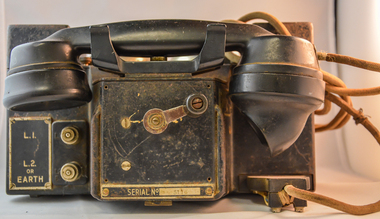
Telephone Handset Field, early 1900s
This field telephone was developed primary for military purposes (World War I) and other wars/military interventions there after. It was the first "mobile" telephone which had a prime objective of providing isolated or "hard" to connect with locations instant communication links. Like a lot of "new" technologies it evolved from a war environment. This handset was used to connect offices and workshops, which due to their functions could not be co-located with their prime office(external workshops).The evolution from the early 1900s to the mid 1980s when mobile communication technology progressed in leaps and bounds from hard wire telephone communication to mobile digital receivers. This handset was manufactured by a subcontracted Australian company under the Australian Post Office mandate.This handset is significant in that it was donated by the Mount Beauty Timber yards and formed an integrated part of its communication system with its out lying work yards and buildings, before the mobile handset evolution. This handset was located in an environment which required a rugged and reliable day to day communications linkage as a vital part of its logistical (business) survival. As progress demands it, the faster that customers are satisfied with the service they obtain from suppliers the longer those services will be asked for and the longer and more profitable the supplier will be. This edict is as true for rural companies as it is for small or large city businesses. The customer is "always" right.This sturdy field telephone has a shell housing made in black bakelite material with a "U" form housing the major components (wiring, magneto and batteries). The main housing has two metal bells, with a central ringer between both, on the top part (to notify incoming calls). In front of the main structure is a box with the telephone hand piece (ear and mouth receptacles) nestled on two cradles. An on/off switch is activated when handset is removed from its cradle. On the front of the control box is a winder handle(to ring off) and in a field situation to activate/deactivate the magneto. To the left of the winder but on the the main body are two wind up connection buttons for the connection of operational wires (power)On the main right hand front body and next to two chrome switches is a plate with "L (next to the top switch) and below this "L2" and underneath this are "or" "EARTH". There is a plate fastened to the front of the handset and behind the winder with "REPLACE HANDSET WHEN FINISHED" and below the winder 'SERIAL NUMBER 5116"field telephone, world war ii field telephone f mk i -
 Kiewa Valley Historical Society
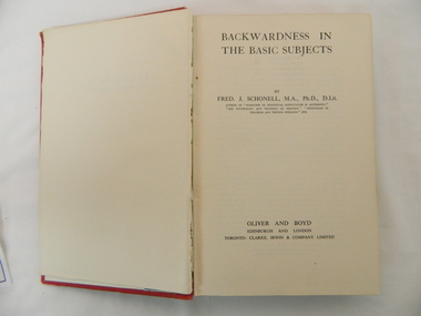
Book - Reference Remedial Education, "Backwardness in the Basic Subjects", 1942 First Edition, reprinted 1952
This publication was produced in the mid 1900s when the study of learning disabilities in children was in its infancy stage. The complexities of teaching methodologies to cover various symptoms uncovered by pre-school and primary school education facilities was that "one method suites all". This format changed in the later 1900s when specific "tailor made" teaching facilities where introduced and the "average" pre-school and primary school teaching professionals where not "on the whole" faced with the requirement to apply special remedial programs themselves but instead instigated a referral to dedicated specialists. This book covers the rural student with slow reading, comprehension and writing problems, in an environment where specialist speech therapists and child psychologists were and are still rare.This book although very thorough and highlights the major "communication and reading symptoms, in school children" and remedial treatment, places undue pressure upon those teachers, who, at some rural schools are faced with teaching classroom of students varying in age and thereby abilities of comprehension. Schools in rural Australia sometimes had smaller numbers of classrooms and facilities due to their small feeder population and their regional isolation. The Kiewa Valley before the dramatic increase in population in the mid 1950s (SEC Hydro Scheme) was one of these rural communities whose "schooling population" was diverse and small. This reference book, which was used at a Kiewa Valley primary school, reflects upon the Department of Education in Victoria as a highly professional organisation readily applying "modern" learning techniques to all of the department's regional areas. By this broad based application, no school was seen as having any disadvantage due to physical and/or financial isolation.This book has a plain red, cloth bonded, hard cardboard cover with an envelope attached to the inside back cover. The book has a one front blank flyleaf and two rear flyleaves. All lettering ,diagrams, sketches are in black on white as is the only photograph.There is three double sided "preface" pages and nine "contents" pages. There are 508 double sided pages covering 20 chapters and 25 double sided Appendices (5) and four double sided "Index Of Subjects". The cover has printing only on the spine.On the spine at the top "BACKWARDNESS IN THE BASIC SUBJECTS" underneath "SCHONELL" and at the bottom "OLIVER & BOYD"teacher reference books, remedial programs for disadvantages school children, special needs education programs, teacher training -
 Kiewa Valley Historical Society
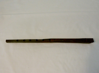
Whistle Penny, circa 1950s
This item is a cheap Penny Whistle made in Thailand Circa 1955. The item was one of the first wave of imports from the growing Asian steel producers. This was an era where cheaper Asia based steel companies did not compete against the stronger, and well established Australian ones. This Penny Whistle was "roughly" made and possibly purchased by the Victorian Education Department for use in school bands and music classes. Schools within the Kiewa Valley would have used them to integrate students the fundamentals of reading music and playing basic musical scores. Later conversion from steel to plastics would have been more conducive to multiple users in a classroom environment (more hygienic and rust proof.This item shows how the "cheaper" invasion of all types of manufactured goods from the Asian regions have altered the purchasing patterns of rural Australians(the more traditional consumer). The cost imbalance of purchasing from "The Mother Country (England)" or European supply versus the Asian manufacturers was due to not only the financial pressures post World War II but also in the elimination of Tariff restrictions placed on non favoured suppliers.This tin Penny Whistle is made from rolled tin(steel), cylindrical in shape, with a wooden Fipple plug at the mouth end and six note holes starting half way down the front side evenly spaced and ending 35mm from the bottom. This whistle is in the key of D"G steel & Co. D"music, wind instruments, whistle, celtic music