Showing 2593 items
matching highlights
-
 Vision Australia
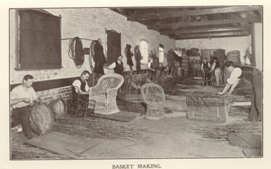
Photograph - Image, Cane workshop pictures from RVIB Annual Reports, circa 1900
Basket weaving and brush making was a source of income for those who worked in the workshops at RVIB and other institutions in New South Wales and Queensland. A diverse range products could be produced with cane, such as cane chairs, cots, washing baskets and trolleys, and the Institution sought to highlight these in the annual report. Over time the demand for, and supply of, cane changed - particularly during World War 2 when Asian sources were under attack or destroyed. At home, other materials such as plastics as well as the ability to import cheaper pre-produced products further reduced the demand for workshop pieces. RVIB eventually closed down it's workshop production of materials in 2009 with the sale of the warehouse in High Street, Prahran and the movement of staff to Macaulay Road, Kensington.6 scanned images of basket making from RVIB annual reportsroyal victorian institute for the blind, employment -
 Melbourne Legacy
Photograph, Parachute team jump for Legacy, 1991
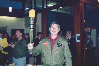
Photograph of a team of Australia's Parachute Display Team, the Red Berets, parachuting into Sandown racecourse for Legacy Week. The yellow paper label says: "Legacy Torch drops on Sandown. The Australian Army's parachute display team, the 'Red Berets' provided a spectacular free-fall display at Sandown racecourse to help highlight Legacy Week. Lt. Col. Matt Chambers carried the Legacy Torch to be used for the Legacy Torch Relay the next day." "Lt. Col. Matt Chambers hands the Legacy Torch to the President after jumping 3,000 feet." Believed to be 1991 as John Sullivan was the president accepting the torch at the racecourse. They were in a folio of photos from 1990 and 1991. Later at Legacy House CEO Terry Walsh is pictured with the red berets.A record of the army being involved in promoting Legacy Week.Colour photo x 8 of red berets parachuting onto Sandown racecourse.Yellow paper label explaining the event in black type.legacy week, legacy promotion -
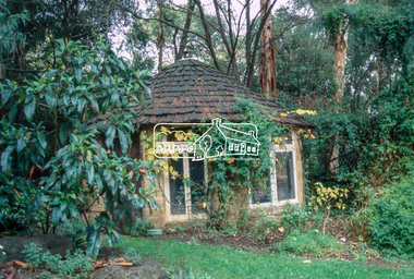
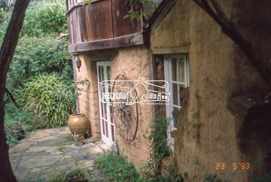
 Eltham District Historical Society Inc
Slide - Photograph, Gordon Ford garden, "Fulling", Pitt Street, Eltham, 23 May 1993
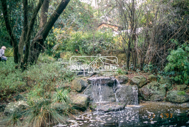
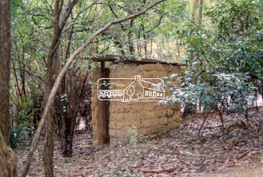
"Fulling", pronounced Fu-elling, the 'display home' of Gordon Ford landscape designer and consultant. From 1945 he transformed one and a half acres of treeless grassland into a splendid bush garden complete with a waterfall and ponds. He used sawdust and wood shavings as a base for the bush floor. The 1993 Eltham Heritage Tour was enjoyed by a busload of members of the Historical Society on a fine, calm day, Sunday May 23rd. Between 10.00 am and 4.30 pm, except for a brief lunch stop at the Eltham Living and Learning Centre, members passed about thirty places of local interest and others recommended for the Historic Buildings Register and the Register of the National Estate. A number of significant trees and buildings were also highlighted along with the opportunity to explored some of the properties.35mm colour positive transparency (1 of 24) Mount - Kodak Kodachromeactivities, shire of eltham historical society, heritage excursion, eltham, fulling, gordon ford garden, pitt street -
 Eltham District Historical Society Inc
Slide - Photograph, Gordon Ford garden, "Fulling", Pitt Street, Eltham, 23 May 1993
"Fulling", pronounced Fu-elling, the 'display home' of Gordon Ford landscape designer and consultant. From 1945 he transformed one and a half acres of treeless grassland into a splendid bush garden complete with a waterfall and ponds. He used sawdust and wood shavings as a base for the bush floor. The 1993 Eltham Heritage Tour was enjoyed by a busload of members of the Historical Society on a fine, calm day, Sunday May 23rd. Between 10.00 am and 4.30 pm, except for a brief lunch stop at the Eltham Living and Learning Centre, members passed about thirty places of local interest and others recommended for the Historic Buildings Register and the Register of the National Estate. A number of significant trees and buildings were also highlighted along with the opportunity to explored some of the properties.35mm colour positive transparency (1 of 24) Mount - Kodak Kodachromeactivities, shire of eltham historical society, heritage excursion, eltham, fulling, gordon ford garden, pitt street -
 Vision Australia
Administrative record - Text, Association for the Blind 89th annual report 1984, 1984
Articles in annual report include: President's report, Finance report with Balance sheet, Auditors' report, Centres and Services by Region, Service highlights, Low Vision Clinics, Education and Training, Radio for the Print Handicapped, Telecommunications, Blind Members, Honorary Service group. During the year the Victorian Blind Bowlers Association were invited to inaugurate the first bowling green at Government House (picture inside front cover), Woodburn Lodge (16 independent living units) were completed, 3RPH was officially opened by Hon.Michael Duffy, Lindsay McMillan won a Churchill Fellowship to study radio information services, and the Telelink service began with 21 groups and 135 participants meeting by June 1984, Telecare servicing over 50 people and Telecontact made with 300 blind or visually impaired people. 1 printed volume with illustrationsassociation for the blind, corporation records -
 Vision Australia
Text, The Association for the Blind, Blind Members' Council meeting minutes 25/3/1991 to 7/2/1994, 1991-1994
These meetings were held at the Kooyong office and the minutes include Present, Chair, Apologies, Minutes, Matter arising from minutes, Correspondence, Life governors, Election of members, Nominations, Reports from Regional Blind Members groups. Some highlights include: 27/7/1992 Mr Ian Moore reported where possible a volunteer driver will be provided to transport members to and from day centres. Where a volunteer driver is not available a taxi will be arranged at the member's expense, with financial hardship cases assisted. 4/3/26/4/1993 a tactile map of AFB Centres has been produced with the assistance of Mr. Danby for members' information. 31/5/1993 it was reported a donation by Mr John Wicking of $50,000 was received to enable the History of the Association to be written by Mr John Wilson. 1 bookassociation for the blind -
Vision Australia
Text, The Association for the Blind Illawarra Community Centre annual meeting minutes 24/9/1976 to 10/9/1993, 1976-1993
These meetings were held at the Illawarra Community Centre and the minutes include Present, National Anthem, Tributes, Apologies, Notice of convening the meeting, Life Governors, Confirmation of previous minutes and Reports from The Chairman, Financial. 1/10/1985 Mrs Heath, founding chairman of the Illawarra Community Centre highlighted that the Centre is based on a unique concept of integrating organisations which traditionally functioned in isolation. The outstanding success of the Centre at this time is consistent with the initial planning and development. At 1985 the Centre had the following user groups Association for the Blind (AFB), Better hearing Australia, Department of Community Services - Rehabilitation unit, Diabetes Found of Victoria, Epilepsy Foundation of Victoria, Paraplegic and Quadriplegic Association of Victoria, Social Organisation for the Handicapped, Victorian Deaf Society and Yooralla Society of Victoria. 2 paper registersassociation for the blind -
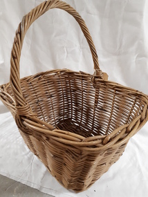 Vision Australia
Container - Object, Cane basket with handle
Basket weaving and brush making was a source of income for those who worked in the workshops at RVIB and other institutions in New South Wales and Queensland. A diverse range products could be produced with cane, such as cane chairs, cots, washing baskets and trolleys, and the Institution sought to highlight these in the annual report. Over time the demand for, and supply of, cane changed - particularly during World War 2 when Asian sources were under attack or destroyed. At home, other materials such as plastics as well as the ability to import cheaper pre-produced products further reduced the demand for workshop pieces. Generic style basket that would have been used for shopping or any household task requiring movement of multiple items. Cane baskets were the original green alternative to plastic shopping bags.1 cane basket with handleemployment, royal victorian institute for the blind -
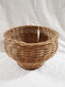 Vision Australia
Object, Small cane basket with solid base
Basket weaving and brush making was a source of income for those who worked in the workshops at RVIB and other institutions in New South Wales and Queensland. A diverse range products could be produced with cane, such as cane chairs, cots, washing baskets and trolleys, and the Institution sought to highlight these in the annual report. Over time the demand for, and supply of, cane changed - particularly during World War 2 when Asian sources were under attack or destroyed. At home, other materials such as plastics as well as the ability to import cheaper pre-produced products further reduced the demand for workshop pieces. Generic style basket could have been used as a rubbish bin or pot plant holder. It has a wide opening, with a combination of two weaves for decoration. The base is a piece of chipboard for strength, and has a decorative covering.1 cane basket with chipboard baseemployment -
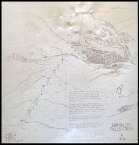 Falls Creek Historical Society
Map - Sun Valley, Falls Creek, 1966
This hand drawn map shows the Gully Chair, Summit Tow and the Village Tow. It also highlights the Nursery Poma. Several buildings can be seen along with the Visitor Centre in the Gully carpark, Skyline can can be seen adjacent to the Gully Chair. The Sun Valley T-Bar was designed by Ron McCallum and began operation in 1967. It had a length of 826 metres and an elevation of approximately 200 metres. In 1989 the Sun Valley T-Bar was replaced by the Scott Quad. Ron McCallum was a founder of Alpine Developments. It appears that his first lift was the Skyline portable tow at Falls Creek in 1954. As an engineer, he went on to build about 20 chairlifts and T-bars in the 1960s and early 1970s including at least five at Falls Creek. This map is significant because it shows plans for the development of a major tow at Falls Creek in the 1960s.A framed black and white concept map for the proposed new lift in Sun Valley, Falls Creek.sun valley tow, ron mccallum, falls creek tows -
 Melbourne Legacy
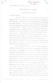
Document - Report, Future Requirements Committee: third and final report (H53), 1978
A report by the Future Requirements Committee dated 11 October 1978. The Committee members were(Chairman): I.W. Anderson, E. Cohen, A.N. Kemsley, L.D. King, J.M. Poulton, R.L. Simmons The Committee notes that its recommendations would probably be resisted by some Legatees but were necessary to meet the changing needs of dependants. They highlighted cancelling the supply of firewood, cessation in 1978 of the Badge Day appeal in Melbourne and the special Christmas promotion, and the Christmas Garden Party at Government House. Boys and Girls classes to be phased out, and Blamey House and Stanhope residences to be closed in 1979-80, with dental care to cease in 1980. They also recommended that more use should be made of labour available from ALL Legatees, and Legacy staff should be strictly monitored as the changes were brought into effect.After two World Wars, Melbourne Legacy recognised that the need for their traditional services was changing and they needed to be vigilant about the transparency of their expenditure.5 photocopied foolscap pages - poor qualityPage 1: 'Copy President from ER' in red ballpoint, 'H53' in blue ball point, 'B' in black.review committee, planning -
 Melbourne Legacy
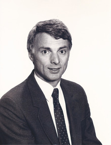
Photograph - Portrait, President Tony Norris 1990, 1990
Photograph of President A. P. (Tony) Norris who was President of Melbourne Legacy in 1990. Appears to be a professional photo taken for use in publications during his term as president. The photo appeared in the President's Highlights report in 1989 to introduce him as the new President. The caption mentioned 'Tony Norris was born in melbourne and now lives with his wife Barbara and two daughters in Essendon. Working at the MMBW in 1966 he was conscripted and joined the 7th battalion R.A.R. Between 1967/68 he saw active service in Vietnam and on return from service rejoined the Board of Works. He is currently Director of Human Resources of that organisation and joined Melbourne Legacy in 1972. He has held the position of Branch Chairman and served on many committees and was recently Senior Vice-President on the Board of Management.'A record of the past presidents of Melbourne Legacy.Black and white photo of President Tony Norris and a pink paper label.Typed paper label says "Mr. Tony Norris President Melbourne Legacy as of 31.01.1990". past presidents, portrait -
 Merri-bek City Council
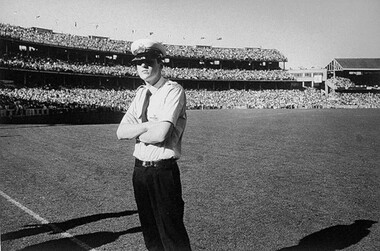
Giclee print, Rennie Ellis, Policeman, Jolimont 1973, 1973
Rennie Ellis (1940–2003) was as a pivotal figure in Australian visual culture. He was both a documentary photographer and a prominent presence in advertising, television and photography. Ellis was known for his candid documentary images of contemporary Australian life. His photographs of social events, such as music festivals, fashion parades or nightclubs are iconic, but his practice also encompassed the grittier side of life. In his AFL series, Ellis skilfully portrays the nation’s passion for the game, extending his lens beyond the boundary line to showcase the spirited fans alongside the on-field action. In Ellis' photo, a young police officer stands on the stadium ground with his arms sternly crossed, while the crowd waits for the game. This photo highlights the tension between passionate crowds and the police at AFL games. -
 Ringwood and District Historical Society
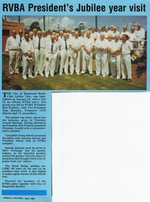
Photograph, Ringwood Bowling Club- RVBA President's Jubilee year visit, 1990
Colour photographPictured are members of the RVBA party together with City of Ringwood bowlers. "Text attached to photograph" The City of Ringwood Bowls Club Jubilee Year, was highlighted on January 18, with a visit by an official RVBA party. The group was led by RVBA President Bob Poulton, with Vice-President Sam Murphy, Treasurer Cliff Martin and 13 councillors. A commemorative pennant was presented to Club President Arnold Bartling. Special mention was given to Merv Pottenger and his garden helpers for the beautiful gardens around the greens. -
 Ringwood and District Historical Society
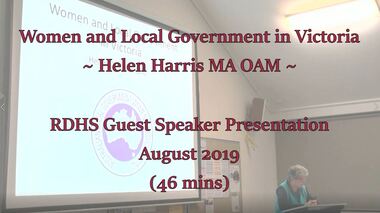
Mixed media - Video, RDHS Guest Speaker Presentation - Women in Local Politics - Helen Harris MA OAM
Digitised video (1.97GB). Duration: 46 minutes. Recorded August, 2019 (Video is available for viewing at Ringwood & District Historical Society Archives by appointment)Helen Doxford Harris is a professional genealogist and historian of more than thirty years standing. Her interest in history was first developed when she commenced researching her family history. She has written many texts on various subjects relating to Victoria Police, the Indigenous and women’s fields of study. Helen is also current Secretary of Box Hill Historical Society. In this presentation, Helen presents a great talk on Women in Politics, highlighting the difficulty in achieving equality in representation on the political stage. -
 Eltham District Historical Society Inc
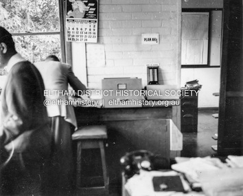
Album - Photograph, J.A. McDonald, Garden Hill, Kangaroo Ground, Feb. 1963
Most likley the interior of the Eltham Shire Offices at the corner of Artur Street and Main Road. The calendar is set on February 1963. ERngineering and Planning were also loacted in the shop fronts located next door on Main Road.Record of various Shire of Eltham infrastructure works undertaken during the period of 1952-1962 involving bridge and road reconstruction projects, sometimes with Eltham Shire Council Project Reference numbers quoted. It was during this period that a number of significant improvements were made to roads and new bridges constructed within the shire that remain in place as of present day (2022). In many situations, the photos provide a tangible visible record of infrastructure that existed throughout the early days of the Shire. The album was put together by or under the direction of the Shire Engineer, J.A. McDonald.arthur street, eltham, eltham shire office, main road, 1963-02 -
 Victorian Aboriginal Corporation for Languages
Book, Australian Institute of Aboriginal and Torres Strait Islander Studies, National Indigenous languages survey report 2005, 2005
The National Indigenous Languages Survey Report 2005 highlights that: of an original estimated 250 known Australian Indigenous languages, only 18 languages are now considered 'strong' and have speakers in all age groups; about 110 Indigenous languages are still spoken by older people but are endangered; words and phrases are still in use and there is community support in many parts of the country for reclamation and learning programs for many other languages which are no longer fully spoken; communities around Australia possess many of the elements required to keep Indigenous languages strong or to reclaim them. They have skilled and devoted language workers and teachers, excellent teaching materials, good documentation of languages and active community language centresmaps, colour photographs, tables, graphsaboriginal english, education, aiatsis, fatsil, language endangerment, language maintenance, language revival, language policy, language proficiency -
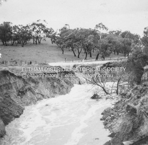
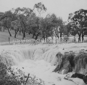
 Eltham District Historical Society Inc
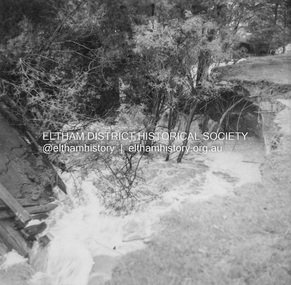
Album - Photograph, J.A. McDonald, Dixons Creek Road, 23 Sep. 1955
Dixons Creek in floodRecord of various Shire of Eltham infrastructure works undertaken during the period of 1952-1962 involving bridge and road reconstruction projects, sometimes with Eltham Shire Council Project Reference numbers quoted. It was during this period that a number of significant improvements were made to roads and new bridges constructed within the shire that remain in place as of present day (2022). In many situations, the photos provide a tangible visible record of infrastructure that existed throughout the early days of the Shire. The album was put together by or under the direction of the Shire Engineer, J.A. McDonald.1955-09-23, bridge construction, dixons creek bridge, dixon's creek road, flood damage, floods, infrastructure, road construction, shire of eltham -
 Eltham District Historical Society Inc
Album - Photograph, J.A. McDonald, Dixons Creek Road, 23 Sep. 1955
Dixons Creek in floodRecord of various Shire of Eltham infrastructure works undertaken during the period of 1952-1962 involving bridge and road reconstruction projects, sometimes with Eltham Shire Council Project Reference numbers quoted. It was during this period that a number of significant improvements were made to roads and new bridges constructed within the shire that remain in place as of present day (2022). In many situations, the photos provide a tangible visible record of infrastructure that existed throughout the early days of the Shire. The album was put together by or under the direction of the Shire Engineer, J.A. McDonald.1955-09-23, bridge construction, dixons creek bridge, dixon's creek road, flood damage, floods, infrastructure, road construction, shire of eltham -
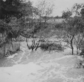
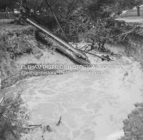 Eltham District Historical Society Inc
Album - Photograph, J.A. McDonald, Dixons Creek Road, 23 Sep. 1955
Dixons Creek in flood Temporary bridge washed outRecord of various Shire of Eltham infrastructure works undertaken during the period of 1952-1962 involving bridge and road reconstruction projects, sometimes with Eltham Shire Council Project Reference numbers quoted. It was during this period that a number of significant improvements were made to roads and new bridges constructed within the shire that remain in place as of present day (2022). In many situations, the photos provide a tangible visible record of infrastructure that existed throughout the early days of the Shire. The album was put together by or under the direction of the Shire Engineer, J.A. McDonald.1955-09-23, bridge construction, dixons creek bridge, dixon's creek road, flood damage, floods, infrastructure, road construction, shire of eltham -
 Eltham District Historical Society Inc
Album - Photograph, J.A. McDonald, Dixons Creek Road, Oct. 1955
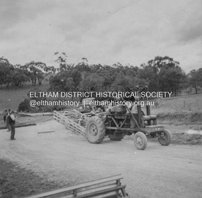
October 1955 Bringing up Bailey panelsRecord of various Shire of Eltham infrastructure works undertaken during the period of 1952-1962 involving bridge and road reconstruction projects, sometimes with Eltham Shire Council Project Reference numbers quoted. It was during this period that a number of significant improvements were made to roads and new bridges constructed within the shire that remain in place as of present day (2022). In many situations, the photos provide a tangible visible record of infrastructure that existed throughout the early days of the Shire. The album was put together by or under the direction of the Shire Engineer, J.A. McDonald.infrastructure, road construction, shire of eltham, 1955-10, bailey bridge, bridge construction, dixons creek bridge, dixon's creek road -
 Eltham District Historical Society Inc
Album - Photograph, J.A. McDonald, Dixons Creek Road, Oct. 1955
October 1955 Ramping north sideRecord of various Shire of Eltham infrastructure works undertaken during the period of 1952-1962 involving bridge and road reconstruction projects, sometimes with Eltham Shire Council Project Reference numbers quoted. It was during this period that a number of significant improvements were made to roads and new bridges constructed within the shire that remain in place as of present day (2022). In many situations, the photos provide a tangible visible record of infrastructure that existed throughout the early days of the Shire. The album was put together by or under the direction of the Shire Engineer, J.A. McDonald.infrastructure, road construction, shire of eltham, 1955-10, bailey bridge, bridge construction, dixons creek bridge, dixon's creek road -
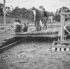
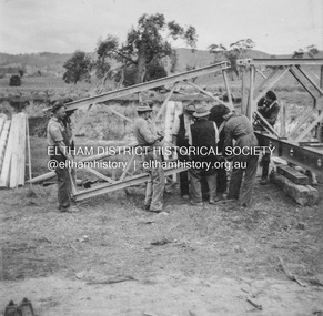 Eltham District Historical Society Inc
Album - Photograph, J.A. McDonald, Dixons Creek Road, Oct. 1955
October 1955 Erecting Bailey BridgeRecord of various Shire of Eltham infrastructure works undertaken during the period of 1952-1962 involving bridge and road reconstruction projects, sometimes with Eltham Shire Council Project Reference numbers quoted. It was during this period that a number of significant improvements were made to roads and new bridges constructed within the shire that remain in place as of present day (2022). In many situations, the photos provide a tangible visible record of infrastructure that existed throughout the early days of the Shire. The album was put together by or under the direction of the Shire Engineer, J.A. McDonald.infrastructure, road construction, shire of eltham, 1955-10, bailey bridge, bridge construction, dixons creek bridge, dixon's creek road -
 Eltham District Historical Society Inc
Album - Photograph, J.A. McDonald, Dixons Creek Road, Oct. 1955
October 1955 Construction of Bailey BridgeRecord of various Shire of Eltham infrastructure works undertaken during the period of 1952-1962 involving bridge and road reconstruction projects, sometimes with Eltham Shire Council Project Reference numbers quoted. It was during this period that a number of significant improvements were made to roads and new bridges constructed within the shire that remain in place as of present day (2022). In many situations, the photos provide a tangible visible record of infrastructure that existed throughout the early days of the Shire. The album was put together by or under the direction of the Shire Engineer, J.A. McDonald.infrastructure, road construction, shire of eltham, 1955-10, bailey bridge, bridge construction, dixons creek bridge, dixon's creek road -
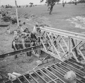
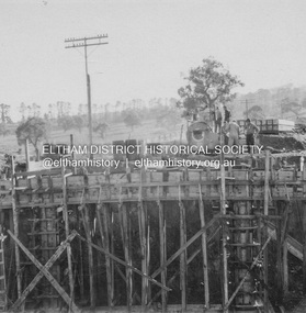 Eltham District Historical Society Inc
Album - Photograph, J.A. McDonald, Dixons Creek Road, June 1957
Bridge over Dixons Creek Job 56FD330 June 1957 Formwork for Dixons Creek pier completed Advertising (1957, January 19). The Argus (Melbourne, Vic. : 1848 - 1957), p. 33 (Col. 9). Retrieved August 24, 2022, from http://nla.gov.au/nla.news-article71777065 SHIRE OF ELTHAM. Loan No. 27.-Notice of Intention to Borrow Sum of £ 15,000 for Permanent Works and Undertakings. - Notice is hereby given, that the Council of the Shire of Eltham proposes to borrow the sum of £15,000 on the credit of the municipal revenues of the president, councillors, and ratepayers for the said shire, such sum to be raised by the Issue of debentures in accordance with the provisions of the Local Government Acts. 1. Maximum rate of interest that may be paid is £5/10/ per cent, per annum. 2. The purposes for which the loan is to be applied are: Construction of Sanitary Conveniences at Shire Office, Council's contribution towards costs of Dixons Creek Bridge, Construction of Mt. Pleasant rd., Construction of Cherry Tree rd. 3. The period of the loan shall be 10 years. 4. Moneys borrowed will be repayable by providing out of the Municipal Fund twenty half-yearly instalments of approximately £985/1/6 each, including principal and interest on the first day of October and the first day of April during the currency of the loan. The first Instalment shall be payable on the first day of October 1957. 5. Such moneys shall be repayable at the Commercial Bank of Australia Limited, Melbourne, or at the Council's bankers for the time being in Melbourne. The plans and specifications and the estimates of the costs of the proposed works and a statement showing the proposed expenditure of the moneys to be borrowed are open for inspection at the Shire Office, Eltham. R. J. HAM. Shire Secretary.Record of various Shire of Eltham infrastructure works undertaken during the period of 1952-1962 involving bridge and road reconstruction projects, sometimes with Eltham Shire Council Project Reference numbers quoted. It was during this period that a number of significant improvements were made to roads and new bridges constructed within the shire that remain in place as of present day (2022). In many situations, the photos provide a tangible visible record of infrastructure that existed throughout the early days of the Shire. The album was put together by or under the direction of the Shire Engineer, J.A. McDonald.infrastructure, road construction, shire of eltham, bridge construction, dixons creek bridge, dixon's creek road, 1957-06 -
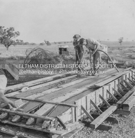 Eltham District Historical Society Inc
Album - Photograph, J.A. McDonald, Dixons Creek Road, June 1957
Piles being cast 1957 P. Morris on vibrator Advertising (1957, January 19). The Argus (Melbourne, Vic. : 1848 - 1957), p. 33 (Col. 9). Retrieved August 24, 2022, from http://nla.gov.au/nla.news-article71777065 SHIRE OF ELTHAM. Loan No. 27.-Notice of Intention to Borrow Sum of £ 15,000 for Permanent Works and Undertakings. - Notice is hereby given, that the Council of the Shire of Eltham proposes to borrow the sum of £15,000 on the credit of the municipal revenues of the president, councillors, and ratepayers for the said shire, such sum to be raised by the Issue of debentures in accordance with the provisions of the Local Government Acts. 1. Maximum rate of interest that may be paid is £5/10/ per cent, per annum. 2. The purposes for which the loan is to be applied are: Construction of Sanitary Conveniences at Shire Office, Council's contribution towards costs of Dixons Creek Bridge, Construction of Mt. Pleasant rd., Construction of Cherry Tree rd. 3. The period of the loan shall be 10 years. 4. Moneys borrowed will be repayable by providing out of the Municipal Fund twenty half-yearly instalments of approximately £985/1/6 each, including principal and interest on the first day of October and the first day of April during the currency of the loan. The first Instalment shall be payable on the first day of October 1957. 5. Such moneys shall be repayable at the Commercial Bank of Australia Limited, Melbourne, or at the Council's bankers for the time being in Melbourne. The plans and specifications and the estimates of the costs of the proposed works and a statement showing the proposed expenditure of the moneys to be borrowed are open for inspection at the Shire Office, Eltham. R. J. HAM. Shire Secretary.Record of various Shire of Eltham infrastructure works undertaken during the period of 1952-1962 involving bridge and road reconstruction projects, sometimes with Eltham Shire Council Project Reference numbers quoted. It was during this period that a number of significant improvements were made to roads and new bridges constructed within the shire that remain in place as of present day (2022). In many situations, the photos provide a tangible visible record of infrastructure that existed throughout the early days of the Shire. The album was put together by or under the direction of the Shire Engineer, J.A. McDonald.infrastructure, road construction, shire of eltham, bridge construction, dixons creek bridge, dixon's creek road, 1957-06, p. morris