Showing 3152 items matching "miles"
-
 Ballarat Tramway Museum
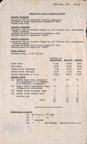
Document - Report, State Electricity Commission of Victoria (SECV), "Details of SEC Tramways System", 15/07/1971 12:00:00 AM
Yields information about the three Provincial systems on a short report - track, rolling stock and a short history.Report - single foolscap sheet, typed, titled "Details of SEC Tramways System", prepared by Les Denmead, 15/7/1971m listing the three Provincial tramways, track details, size, rolling stock and notes including miles of tracks. Gives some details of the then current fleet.trams, tramways, reports, geelong, ballarat, bendigo, track, tram tracks, rolling stock -
 Melbourne Tram Museum
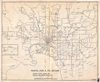
Map, Melbourne & Metropolitan Tramways Board (MMTB), "MMTB Tram and Bus Sections", mid 1960's?
Map - photocopy - titled "MMTB Tram and Bus Sections" showing tram tracks and bus routes, drawing No. P13842, c mid 1960's, Footscray and Point Ormond shown as bus. Shows railway lines, station, some cross streets. Scale 1"=1 Mile.trams, tramways, map, buses, melbourne, footscray -
 Federation University Historical Collection
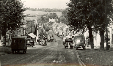
Postcards - black and white, Butt Bourton, Burford
Burford is a small town on the River Windrush in the Cotswold hills in west Oxfordshire, England, about 18 miles (29 km) west of Oxford, 22 miles (35 km) southeast of Cheltenham and only about 2 miles (3 km) from the Gloucestershire boundary. The toponym derives from the Old English words burh meaning fortified town or hilltown and ford, the crossing of a river. (Wikipedia)A streetscape photographic view of Burford, England showing buildings, cars and people. chatham family archive, burford -
 Bendigo Military Museum
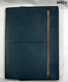
Administrative record - FOLDER, 2) & .3) Geographical Section, General Staff, No 4080 War Office 1941 et al, Navigator's Log Book, 2) & .3) 1941
.1) Navigator's Log Book, hard cover, blue colour buckram with dark blue paint on front cover. Back end paper includes a pocket for maps & has a Conversion Table & Nautical Miles, Statute Miles, Kilometres, tables in black print on beige paper included. Stiff card divider. .2) Map folded, black printing on beige paper. Gibraltar Scale 1:1,000,000 at 56 degrees N. .3) Map folded, black printing on beige paper. Algeria Scale 1:1,000,000 at 56 degrees N. .4) Pencil grey lead, timber colour. Stamped into pencil: HB Commonwealth of Australia..1) Hand written in black ink on front end paper: Wreck at Cape Juby. In pencil: S2 / MZ / W2 / 1Z . 35N .2) Hand written in blue pencil: Atlantic. Blue & red ink & lead pencil notations over map. .3) Hand written in blue pencil: Mediterranean. Blue & red ink numerous notations over map.documents - maps/records, military history, passchendaele barracks trust -
 Ballarat Tramway Museum
Photograph - Digital image Set of 2, Mal Rowe, 29/06/1968 12:00:00 AM
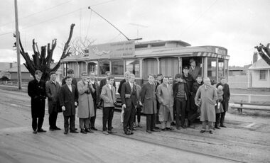
Yields information about the purported achievement of tram 27 reaching 1,000,000 miles and the TMSV Tour, and has a strong association with the tour participants.Set of two Digital images of a Black and white photographs of the tour participants for Tram 27 during the celebrations of the tram completing its "millionth" mile in Ballarat on Saturday 29 June 1968. Photographed on the Grey St loop, Albert St Sebastopol, probably while waiting for another tram. Tram showing "Special", has banner "This tram has just completed 1,000,000 (million) miles in Ballarat" on the front of the tram during the TMSV Celebratory tour. See also Reg Items 1878 and 7990 to 7995 for other photos of the day by Mal Rowe. Note: A review of the tram car mileages by Dave Macartney, showed that it was actually 900,000, due to a carryover error.trams, tramways, tmsv, million miles, sebastopol, albert st, grey st loop, group photo, tram 27 -
 Ballarat Tramway Museum
Photograph - Digital image, Mal Rowe, 29/06/1968 12:00:00 AM
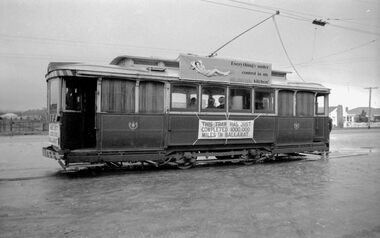
Yields information about the purported achievement of tram 27 reaching 1,000,000 miles and the TMSV Tour and the Sebastopol terminus.Digital image of a Black and white photograph of Tram 27 at Sebastopol terminus during the celebrations of the tram completing its "millionth" mile in Ballarat on Saturday 29 June 1968. Note the undeveloped land on the opposite side of Albert St and the overhead pan used to help centre the pole at night. Tram showing "Special", has banner "This tram has just completed 1,000,000 (million) miles in Ballarat" on the front of the tram during the TMSV Celebratory tour. See also Reg Items 1878 and 7990 to 7995 for other photos of the day by Mal Rowe. Note: A review of the tram car mileages by Dave Macartney, showed that it was actually 900,000, due to a carryover error.trams, tramways, tmsv, million miles, albert st, sebastopol, tram 27 -
 Wodonga & District Historical Society Inc
Album - Hume Reservoir Australia Album - Dimensions of Hume Reservoir, Department of Public Works, N.S.W, 1927
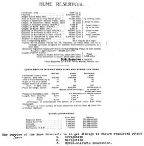
This set of photos is from a leather bound album bearing the inscription "HUME RESERVOIR AUSTRALIA" plus 'The Rt. Hon. L. C. M. S. Amery, P. C., M .P.' all inscribed in gold. It was presented to The Rt. Hon. L. C. M. S. Amery, P. C., M. P, Secretary of State for Dominion Affairs on the occasion of his visit to the Hume Reservoir on 2nd November 1927. This album is of local and national significance as it documents the planning and development of the Hume Reservoir up to 1927. It was the largest water reservoir in the British Empire. The album records the pioneering engineering work that went into its construction.Table outlining the Dimensions of the Hume Weir and comparisons with MAKWAR and BURRINJUCK DAMS, and some other comparisons. MAKWAR Dam is located on the Blue Nile about five miles south of Sennar and 175 miles south of Khartoum in Sudan. The construction of this dam started in 1922 and was completed in May 1925, while the British Empire colonised Sudan. It was officially opened on 21st January 1926. The BURRINJUCK DAM is situated in the upper catchment of the Murrumbidgee River, approximately 60 kms from Yass, N.S.W. It was built from 1907 to 1927 The stated purpose of the Hume Reservoir is to get storage to ensure regulated output for:- 1. Irrigation 2. Navigation 3. Hydro-electric Generation.hume reservoir australia, river murray waters scheme, hume dimensions -
 Stawell Historical Society Inc
Drawing, Stawell Water Supply Bovine Aqueduct 1881 -- Sketch
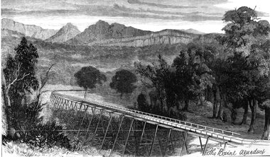
Sketches of Stawell Water Supply Bovine Aqueduct October 5th 1881. The Grampian scheme planned by the the Borough Engineer John D'Alton. D'Alton's suggestion was that the water be carried from the source in an open channel two miles, then in a flume of timber. Later surveyed and planned a tunnel on a good line - to reduce the flume 72 miles and the main to Stawell to 15 miles. This sketch (illustrated Australian News October 5, 1881).Black and white photograph of a sketch a bush scene with mountains in background. The sketch depicts a trestle bridge construction. The Bovine Aqueduct stawell water supply -
 Ringwood and District Historical Society
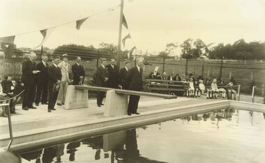
Photograph, Opening the old Ringwood Baths in Ringwood Street, 1934
Black and white photograph- 2 copiesTyped below photograph, "The Mayor, Mr A. T. Miles opening the old Ringwood Baths in Ringwood Street, 1934" Date 10/11/1934. -
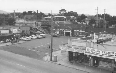
 Ringwood and District Historical Society
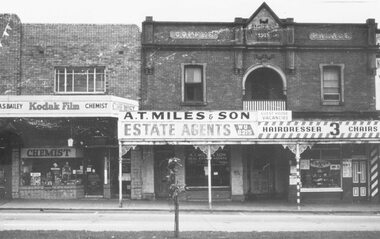
Photograph, Maroondah Highway Central, Ringwood. Coffee Palace and shops opposite Railway Station entrance- c1966
Black and white photograph. (2 copies).Image shows shops including A.S. Bailey Chemist, A.T. Miles & Son Estate Agents, entrance to Coffee Palace, and Roy Hill's Hairdresser. -
 Ringwood and District Historical Society
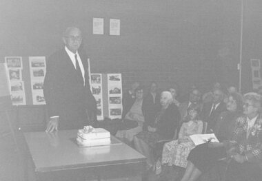
Photograph, 1979 Ringwood Historical Research Group 20th Annual General Meeting
Catalogue card reads, '1979. Ringwood Historical Research Group 10th Annual General Meeting, Sept. 1979. Photograph of Paddy Miles with cake'. -
 Ringwood and District Historical Society
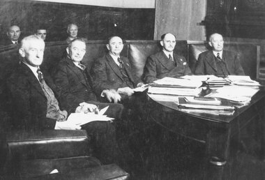
Photograph, Ringwood Council members- 1946/47
Black and white photographs (2 original mounted on cardboard, 2 copy)Written under copy of photograph: L-R, F.W. Caterer E. Purser, B. Hubbard, H. Pearson, A.T. Miles, 1946-1947". -
 Ringwood and District Historical Society
Photograph, Maroondah Highway Central, Ringwood. Town Hall rooftop view of Railway station entrance. c.1962
Black and white photograph (2 images)Written on back of one photograph: "Town Hall roof Dec, 1962. Series taken by Paddy Miles." Image shows Methodist Church in background. -
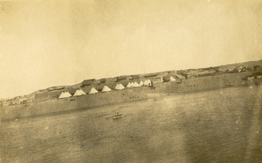 Federation University Historical Collection
Photograph - Sepia Postcard, Suez Canal Camp, c1916
The postcard was written on by Harry Holmes who was a member of the Australian Imperial Force based in Egypt at the time. Egypt was a major base for the AIF from December 1914. A number of campaigns were fought in this theatre. There were two campaigns involving the AIF. Note that not all the fighting was actually geographically in Egypt. (http://www.aif.adfa.edu.au:8888/about3.html) Sepia photograph showing a number of tents used by Australian soldiers during World War One, with the Suez Canal in the foreground. Verso "A camp five miles from ours. Snap take [3 words covered in blue pencil by the censor - they appear to say 'across the Canalchatham family archive, chatham, holmes, world war, world war 1, world war i, world war one, harry holmes, suez canal, egypt, ascot -
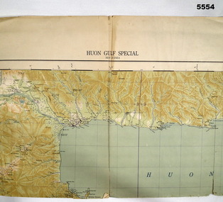 Bendigo Military Museum
Map - MAP, HUON GULF AREA, Aust Survey Corps et al, Aug 43
Refer Cat 5547 - Matheson.This is a single sided map, printed in colour. Scale 1:253,440, 4 miles to an inch, grid squares are 10mm x 10mm. Top right side shows Finschafen. Top centre is Lae, Middle is Salamau. Bottom is Lasanga Island. Top left vicinity is Nadzab and Markham River.There are four "corner" marks in pencil. Two on land and two out in the gulf.ww2, new guinea, map -
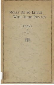 Bendigo Historical Society Inc.
Book - ALEC H CHISHOLM COLLECTION: BOOK 'MOLES DO SO LITTLE WITH THEIR PRIVACY' BY ''E''
Booklet. ALEC H CHISHOLM COLLECTION. 63 page soft cover book of poems by ''E''. Preface by T. Inglis Moore and explanatory notes by Miles Franklin. Published in 1942 by Angus & Robertson, Sydney and printed by The Snelling Printing Works, Sydney. Catalogue sticker '2061 E' on spine.''E''books, collections, poetry, alec h chisholm collection, ''e'', t.inglis moore, miles franklin, poetry -
 Beechworth Honey Archive
Hand-Drawn Map Centred on Worouly by Frank Lebbell Frost December 1916
This is one of the maps drawn by Frank L. Frost while he was beekeeping in North-East Victoria. This particular map may be reference in the "Wooden" Diary on page 10.Hand-drawn map centred on Whorouly and showing other towns, including Oxley, Byrne, Edi and Whitfield. Details the local flowering eucalypts. Scale is each red square equals three miles. Drawn with black pen and grey lead on paper. Grid and other features are marked in red.hand drawn, hand-drawn, map, oxley, byrne, whitfield, edi, frost, beekeeping, beechworth honey -
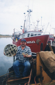 Lakes Entrance Historical Society
Photograph - Sonja, Lakes Post Newspaper, 2000
Article in Lakes Post Newspaper 25 October, 2000 re wreckage found 12 nautical miles S.W. of the entrance and 3.2 nautical miles off the beach. Also colour photograph of two unidentified crew members of Sonja Colour photograph showing Arno Blank, owner / skipper, and crew of scallop boat Sonja with WW2 aeroplane wreckage dredged up in Bass Strait, at Lakes Entrance, Victoria. ships and shipping, fishing industry, people, ww2 plane salvage -
 Wycheproof & District Historical Society Inc.
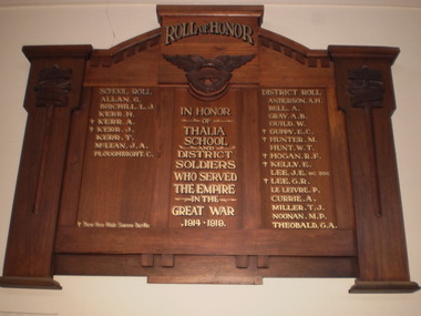
Roll Of Honor, THALIA SCHOOL and DISTRICT SOLDIERS WHO SERVED WW1, Early 20th Century
Thalia is a small district a few miles west of Wycheproof.Record of WW1 veterans' contributions from small district - Thalia, Victoria.Large wooden Roll Of Honor. Decoration of wooden sword attached each side. Under Heading ROLL OF HONOR (note No letter U in this word heading), is a raised wooden wing. HONOR ROLL is in 3 columns- SCHOOL ROLL; IN HONOR OF ... ; DISTRICT ROLL. 23 names on Roll Of Honor.The 23 inscribed names can be seen on the photo which is in the Media section.ww1; thalia-school; thalia; wycheproof - cemetery; veterans. -
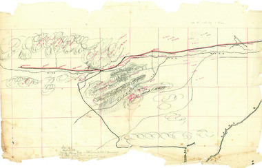
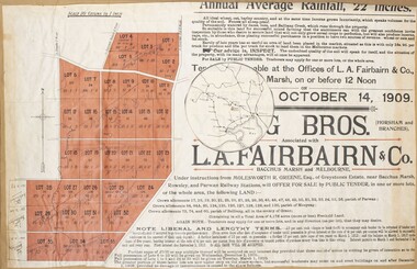 Bacchus Marsh & District Historical Society
Map, Greystones Estate Land Sale 1909
This map was produced sometime around mid 1909 to advertise portions of land from the Greystones Estate for sale by public tender. The selling agents were Young Brothers of Horsham and L.A. Fairbairn of Bacchus Marsh and Melbourne. The seller was Molesworth R. Greene who was a pioneer pastoralist in the Bacchus Marsh area and had also acquired other properties in Victoria and interstate. Molesworth Greene died in 1916 so this sale came towards the end of his life. A total of 4,176 acres was offered for sale in multiple lots. Successful tenderers could buy single or multiple lots. The results of the sale were reported in the Bacchus Marsh Express newspaper on the 16th October 1909, page 3. At the sale a total of 3, 420 acres was sold. A single page paper map showing portions of land for sale from the Greystones Estate near Bacchus Marsh. The map includes extensive details about the property, number of allotments for sale, terms and conditions of the sale and prices. The map includes an inserted reference map showing the location of the property in relation to Melbourne, Geelong, Ballarat and Castlemaine. The top of the map appears to be missing resulting in some loss of the text. The sale notice in the Bacchus Marsh Express of 10 July, 1909, page 3, column 1 appears to duplicate the text overall in the auction plan. Based on this the missing text is likely to be: "Important Subdivisional Sale 'Of Portion of One of the Best and Most Favourably known Estates IN THE RENOWNED BACCHUS MARSH DISTRICT. And situated only six miles from that prosperous township, two miles from Rowsley, and three miles from Parwan, all Railway towns, connected with the Estate by metal roads." Scale: 20 chains to 1 inch The map is pasted into a bound volume containing 76 maps or plans in total. bacchus marsh victoria maps, land sales, land sales bacchus marsh, greystones estate bacchus marsh, molesworth r. green 1827-1916, land sales rowsley -
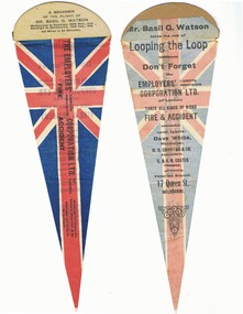 Bendigo Historical Society Inc.
Souvenir - BASIL WATSON COLLECTION: FLIGHT SOUVENIR PENNANT MELBOURNE TO BENDIGO FLIGHT 1916, 1916
Flight souvenir of Basil Watson in pennant shape. Union Jack design on front. Advertisement for 'Employers' Liability Insurance Corporation Ltd (of London) on back. A souvenir of the flight of B. Watson, Melbourne to Bendigo, 29th Nov 1916 and Bendigo to Melbourne, 15th Dec. 1916. '' 100 miles in 65 minutes''.person, bendigo, basil watson -
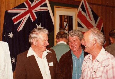 8th/13th Victorian Mounted Rifles Regimental Collection
Photograph
Cambrai Day is celebrated annually by Armoured Corps regiments of the British Commonwealth. It marks the anniversary of the Battle of Cambrai in November 1917 when a force of more than 400 British Mark IV Tanks broke the defences of the German Hindenburg Line, It was the first large-scale, effective use of tanks in warfare. Cambrai turned from a battle of great success to failure, but it heralded a new type of warfare and changed the nature of the battlefield forever.The gathering at Buna Barracks Albury, Beersheba Barracks Wangaratta, Bapaume Barracks Benalla and Salamaua Barracks Cobram on 30 November 1986 was the inaugural meeting of the 8th/13th Victorian Mounted Rifles Regimental Association.Colour photograph of three men taken at Buna Barracks Albury on Cambrai Day 20 November 1986. From left : Warrant Officer Mick Howes, Sregeant John Bauerle and Staff Sergeant Maurie Miles. All were former NCOs of 8/13 Victorian Mounted Rifles Regiment. -
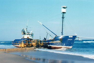 Lakes Entrance Historical Society
Photograph - Dageraad, 1981
Vessel went aground 26 April 1981Colour photograph showing the fishing vessel Dagaraad WSR aground along 90 mile beach. Bulldozer on beach assisting refloating of vessel, two men onboard. Another fishing vessel out at sea on right. Ropes attached to bow of Dagaraad, which went ashore. Lakes Entrance Victoriafishing industry, ships and shipping, shipwrecks, ocean -
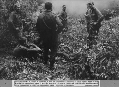 National Vietnam Veterans Museum (NVVM)
Photograph, Gibbons, Denis, Waiting For The Winch
A black and white photograph of diggers from 1 Platoon, A Company, 8 RAR on Operation Atherton, 11 miles North West of the Australian Task Force Base at Nui Dat, wait for the winch to return for another wounded mate to be casavaced to hospital. Casualties were 1 dead and 14 wounded.photograph, 1 platoon, a coy, 8 rar, operation atherton, gibbons collection catalogue, australian task force, nui dat, wounded serviceman, diggers -
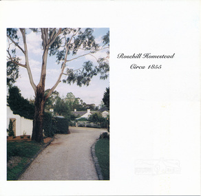 Eltham District Historical Society Inc
Auction Sale Brochure, Rosehill Homestead, 56 Bonds Road, Lower Plenty
Auction sale brochure, Miles Real Estate Professionals, RosannaBrochurehouses, bonds road, lower plenty, miles real estate, rosehill homestead -
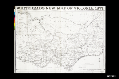 Whitehorse Historical Society Inc.
Map, Whitehead's New map of Victoria, 1877
A map of Victoria produced in 1877non-fictionA map of Victoria produced in 1877map, victoria -
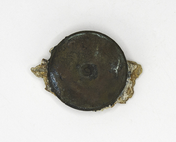 Queenscliffe Maritime Museum
Tool - Measuring Tape
Lost on maiden voyage 40 miles from Cape Otway. A brass measuring tape recovered from the wreck of the Shombergclippers, schomberg, measuring tape -
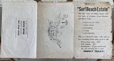 Phillip Island and District Historical Society Inc.
Booklet, Surf Beach Estate, About 1950
W. Davie was a local real estate agentHistoricalBooklet advertising the Surf Beach Estate . Large sheet printed on both sides. One side has map of the estate. other has information about estate, agent and location on Island" Surf Beach Estate" '"The only estate on Phillip island with two miles of Glorious Ocean Beaches and Rock Pools." Prices from only 250 pound.surf beach, real estate, w davie, town planning -
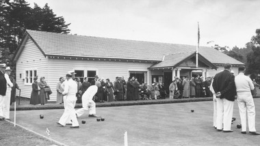 Ringwood and District Historical Society
Photograph, Ringwood Bowling Club- Green opening day, 1954
Black and white photographNote attached to photograph- Ringwood Bowling Club, 1954. Cnr Miles Ave/Warrandyte Rd. Green opening day, 9.9.54 Prior Clubhouse fire. -
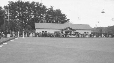 Ringwood and District Historical Society
Photograph, Ringwood Bowling Club- Green opening day, 1958
Black and white photographNote attached to photograph- Ringwood Bowling Club,1958. Cnr Miles Av/Warrandyte Rd. Green opening day 11.9.58. Prior to Clubhouse fire.