Showing 616 items
matching new south building
-
 Parks Victoria - Mount Buffalo Chalet
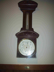
Barometer
"A number of specific items, which have been useful in the day to day operations of the Chalet, remain in the building with each complementing the other to provide context, meaning and character to their setting. Items such as the hall porter bell, the many signs providing information to the guests, the wall clock, barometer and dinner bell point to the Chalet being a well-run social institution with a pleasant environment for rest, recreation and congenial company." (Pg 81 Historica, MBCC) "The barometer mounted on an ornately carved backing was presented by flour miller John Spencer Brunton (1861-1937), son of Thomas Brunton who founded the Brunton & Co. flourmills. John had responsibility for the New South Wales arm of the company and lived in Sydney.' (Pg 82 Historica MBCC) " Fig 80. It was presented by John Spencer Brunton on 9 December 1930."(Pg83, Historica. MBCC) Listed in Draft Inventory of Significant Collection items A.3.. Fixtures and Fittings (Pg 165.Historica, MBCC)Barometer and thermometer with carved decorative leaf pattern wooden surround.On plaque below barometer:"PRESENTED BY / JOHN SPENCER BRUNTON / 9.12.30" (further inscriptions on face) -
 Melton City Libraries
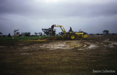
Photograph, Building a new school, 1974
There were no high schools in the area pre 1975, and students from Melton, Melton South and Toolern Vale State Schools went by bus to Bacchus Marsh High School. In 1975, Melton High School opened its doors. Coburn Road named after Coburns, early settlers family and George Coburn Councillor and 1935 Shire PresidentEarth works undertaken for the development of Melton High School, Coburns Road, Melton Westeducation -
 Melton City Libraries
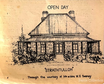
Drawing, Open Day at Strathtulloh, Unknown
"Strathtulloh, 1402-1600 Greigs Road, Melton South, is significant as an early property in Victoria, retaining different eras of pioneering dwellings, ranging from a ruin to a fine Colonial style homestead. The property has close historical association with the early settlement of the Melton district, and was owned by the Henty family in the 1840s. The Strathtulloh property was alienated by the Crown in 1840 to Charles James Garrard, who sold it in 1848 to Charles and Stephen Henty, whose sister Jane and her husband Samuel Bryan lived there in the late 1840s. In 1853 the property then passed to William Tulloh, after whom the homestead was named. A primitive bluestone ruin of near the Toolern Creek, built of vesicular bluestone and mud mortar, is of unknown origin. It has commonly been assumed to pre-date 1840, and to have belonged to the original holder of the Exford lease, Dr Watton or Port Phillip Association member Dr Cotterill. This is unlikely, as the 1841 census records Dr Watton, and everyone else in the district, as living in a ‘wood’ dwelling. It may instead have been the residence of Garrard, and the Bryans, in the 1840s and an early map names a site near here as ‘Bryan’s outstation’. It is assumed that the two-level stone building that became the kitchen is the earliest intact building on the site, and was the first homestead; it is likely to date to the 1840s or 1850s. The main homestead is a substantial villa constructed of random coursed bluestone, with a verandah facing three sides, attic bedrooms with dormer windows, a fan light over the front door, a hipped roof originally clad in slate, and a large cellar. Although demonstrating characteristics of pioneering construction, such as unworked log beams, pit sawn beams, hand-sawn lintels and colonial door locks, documentary evidence shows that it was built c.1869. The homestead has now been structurally repaired and decoratively restored; a sympathetic new semi-detached rear extension was added in the early years of the 21st century. The former kitchen building has also undergone minor repairs and alterations". Strathtulloh Homestead at 1402-1600 Greigs Road, Melton Southlocal architecture -
 Melton City Libraries
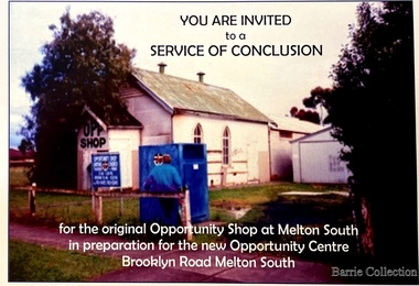
Flyer, Melton South Uniting Church Opportunity Centre, 2016
The Opportunity Shop – Established 1975 by Edna Barrie 1992 In 1985 the need for more shop space became apparent. Les [Bone] had plans drawn up (Surv 12/8/84) and approved by the Melton shire Council for a storeroom extension (17.800 x 9500) 1986 the small ancillary rooms at the rear of the timber church were demolished allowing the concrete slab to be laid. The building was completed in 1987. By the early 1900s the old timber Church had deteriorated, this lead to it being demolished in 2/11/1993. It was replaced with a new building containing a Pastoral Office, a meeting room and a furniture and homeware section. It was dedicated by Rev Ian Hickingbotham at 11am Sunday 5th June 1994. Invites to the service of conclusion of the original Uniting Church Opportunity Centre and official opening to the new shop in Melton Southchurches, local identities -
 Melton City Libraries
Document, Minns Family Reunion, 2004
"A perpetual spring in the adjacent creek provided a steady supply of fresh water to the site on which the homestead is built. Although we can not be certain of the identity of the builder, the first stage of ‘The Willows’ homestead appears to have been constructed in the mid 1850s. The house is situated on Crown Allotment No.1 (No Section), Parish of Kororoit, an allotment of 5 acres 3 roods 4 perches. Although it had surveyed the land, the Crown did not offer it for sale until 22nd November 1861, at which time it was purchased by Charles March Williams. (Although the property is directly opposite and immediately adjacent to the Township of Melton, and was sold as ‘Suburban Allotment 33’, it was situated within the Shire of Braybrook rather than the Shire of Melton until 1917.) Considerable improvements had taken place on the land prior to the Crown sale. When CM Williams purchased the allotment in November 1861 he paid £23.5.0 for the land itself, and valued the improvements at £400. Even allowing for some exaggeration by Williams, this is an extremely high valuation for improvements, and must have included a house. Some local research has claimed that in 1858 Williams had taken over the interest of a Mr Parkinson in the property, and that Parkinson built the house upon taking possession of the land c.1855. It was definitely built by 1861, when a map shows a square building on the site marked as ‘House’. The property is important in the district for its association with the establishment of the pound. The district pound had been established in 1854, when George Scarborough of Mount Cottrell (Mt Cottrell Road, south of Greigs Road) was appointed pound-keeper. Scarborough resigned in 1857. The pound was moved to Melton following agitation from local farmers and Charles March Williams appointed pound-keeper on 26th April 1858. Williams, the son of a doctor, had been born in London. Reminiscences of local residents of the time, as recorded in the Express newspaper, note Williams’ success in breeding horses on the property. Sales of up to 60 guineas were noted. Whether this was from Williams’s own stock or from unclaimed pound stock is not made clear. Williams appeared before a government inquiry in 1860 and advocated registration of all stock brands in the State. Williams died in 1862 leaving a widow, Catherine, and five living children aged 15 years to five months. At the time of his death Williams had entered negotiations with one Matthew Devenish and had a mortgage of £100 on allotments 1 and 2, Parish of Kororoit. Catherine Williams was appointed pound-keeper on 2 September 1863, with her eldest son Charles as her assistant. Her tenure was short for on 22nd March 1864 George Minns senior paid Matthew Devenish £135 for allotments 1 and 2 Parish of Kororoit (considerably less than Williams had claimed the property was worth in 1861) and on the same day paid William Tullidge £45 for the adjoining allotments 3 and 4. In April 1867, James Ebden Minns, the newly married son of George senior became the owner of The Willows property having entered into a mortgage arrangement with his father to the extent of £200. At the time George Minns was residing in Kaarimba having left Melton in 1867 for a short trip to England and upon his return having taken up a selection in the Kaarimba district with his son Frederick who had a hotel licence there. James paid out the mortgage on 2-1-1873. James Minns was appointed pound-keeper in 1872; in 1885 the pound was moved elsewhere and Minns purchased the old pound site and added it to his farm. The Willows residence underwent a major change about this time. A two room extension, similar in style but with a lower elevation was added to the original rear of the house with a chimney matching the distinctive originals. Window arrangements did not match the original but became a feature of the façade when the new addition became the front of the building. Six buttresses were attached to the east and west walls of the old building, two to the south wall and the whole rendered with mortar to give the appearance of dressed stonework around the windows. Galvanized iron was placed over the shingles and a verandah added on three sides. By 1876 The Willows was the homestead for a thriving mixed farm of 340 acres of which 156 was rented from a H. Ruck. In October of that year the Australasian travelling reporter visited and reported on the property. In common with the nearly every other property in the district the farm had ‘recently’ (generally within the last two years) abandoned cultivation of crops, and turned over completely to cattle pasture. Butter making was the principal occupation of the farm, which had about 50 head of cattle, a large proportion of which were milking cows. The reporter also noted that a ‘large number of pigs are kept upon this farm and are found to be very profitable stock’. Their manure was used in an orchard and garden in which ‘large quantities of lucerne and prairie grass are grown for the use of stock when ordinary feed is scarce’. Two bores attached to deep brick lined wells supplied water for the house in addition to the farm. A commodious timber barn and necessary sheds had also been constructed. Access to the property was improved following the construction of the bluestone ford across the creek c.1887, when the recreation ground came into use. Prior to this date it may have been that the crossing referred to as ‘Mr Minns bridge’ was used. This appears to have been a flimsy structure and has but two references in Council reports in the Melton Express in the 1880’s. It is believed that in the late 1890’s a timber building was added near the rear of the building to house a kitchen, ablutions and laundry rooms and rooms for seasonal workers. This was attached to the house by means of a trellised walkway using the original front entry to the house (long since the back door). A photograph of this building appears in a local history of Melton. This was demolished in recent decades during the period when the house was tenanted (after the Minns family had left). James Minns son, George, took over the property following his marriage to Alice Walsh in 1903. James and Caroline moved into a house on the former JH Games property at the eastern end of Henry Street. George held the position of Shire Secretary for Melton for 40 years. He was a most prominent member of the community being Secretary to, among others, the Melton Coursing Club, the Shooting Club and the Cemetery Trust. He also rode with the hunting parties who sported across the Plains and were entertained at Mount Kororoit. George and Alice had one son, Norman who followed his father into local government and became Secretary of the Shire of Werribee completing a record term in this position. George retired to Werribee in 1951, where he died in 1965. The National Trust records note that James Ebden Minns and his sons were ‘leading men of the district, Justices of the Peace, and Shire Councillors’. It claims that Sir Thomas Bent was a frequent visitor. The Willows passed into the hands of George’s grandson, Bruce Minns and the property was let for a number of years. In the 1960s it became vacant and was subject to vandalism. Major structural problems arose with the part demolition of the roof, the loss of windows and doors and holes dug into and under the floorboards. The outbuildings were particularly targeted. Following widespread public support, the Shire of Melton purchased the house, with 3.75 acres of land, in 1972. In 1975 the Shire of Melton and the Melton and District Historical Society were successful in nominating the building for National Trust classification, and then the Australian Heritage Commission’s Register of the National Estate. The AHC particularly noted its ‘townscape importance’. It was envisaged that the farmhouse would form ‘a picturesque centrepiece to Melton’s planned … historical park, along with Dunvegan bluestone cottage … and similar structures as they become available.’ In a time of great Melton’s ‘satellite city’ development the Council spelt out its broader vision in its submission to the AHC: ‘Melton is destined to become, by the end of the present century, a city of between 75,000 and 100,000 people. Significant relics of the past, such as ‘The Willows’, regrettably will be rare in that situation. It is essential that sufficient tangible links with Melton’s pioneering days remain to promote in the new community a sense of history and continuity’. Under the direction of ‘The Willows’ Restoration Committee and consultant architect John Hitch, all outbuildings, with the exception of the garage and toilet, were demolished and the dwelling house restored. Finances were provided by the Shire of Melton and the National Estate Grants Program, and considerable amount of voluntary labour was provided by the local community. The orchard was removed, and remaining wooden buildings were relocated to provide an open vista for visitors to the Park. The property was furnished with donations from district families keen to preserve this example of pioneer life in the area. The Willows became the headquarters of the Melton and District Historical Society". Invitation to the family reunion at the Willowslocal identities, pioneer families -
 Melton City Libraries
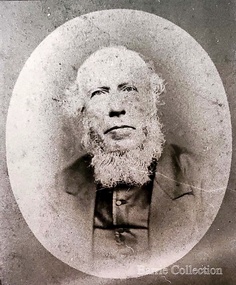
Photograph, Revenant James Lambie, Unknown
Photo is from Werribee District Historical Society and Susan Oliver, descendent of Lambie. Information from Alec Cameron: July 28th Alec Cameron article Late Rev James Lambie came to Melton in 1863 from Paisley, Scotland. He was married the second time. By the first marriage he had one son and two daughters. By the second marriage, one son and three daughters. The second son was Mr William John Lambie. When Rev Mr Lambie took charge of the Presbyterian church it was held in a wooden building. He was a good preacher. He and his family took great interest and commenced to form a committee to collect funds to build a new bluestone church. The collected the rent money for the building. Mr Lambie lived for several years in Melton before he went to Wyndham Church to take charge there, and the family went to live there also. The reason was that the Melton Congregation could not provide the stipend he required. He came from Wyndham on a Saturday and preached to the congregation on Sunday morning and then went back to Wyndham to continue his services in the afternoon and evening. After a few years, Rev Lambie retired from the ministry and purchased a house in South Yarra where he and Mrs Lambie died. The eldest daughter Jessie, married James Scott a teacher at the Melton School. They left Melton and while teaching near Melbourne he got his BA and other degrees. He then purchased the Warnambool College for L5000 and resided there for a number of years. His wife predeceased him. There were two sons and two daughters. He was a brother-in-law of the late Mr Lang wine and spirit merchant Collins street, who was the Mayor of the City Council. His brother Mr Robert Scott was the licensee of the hotel at the corner of Bourke and Russell St and one of Mr Scott’s daughters married Mr Smith, solicitor, a nephew of the late Mr Smith of Toolern Vale, and another one married Dr Officer of Warnambool. They went to Western Australia to reside and Mr J Scott with them. He died abour 6 years ago. Miss Lambie the second eldest daughter, married Mr Samual McDonald, JP, butcher and Clerk of Courts, Melton and late correspondent for the Bacchus Marsh Express. He also acted as the Shire Secretary for the Melton Shire, and got an auctioneer’s license while here. He then left Melton to go to Shepparton, where he became the President of the Shire and the Clerk of Courts. Before he left Melton he was presented with a purse of sovereigns from the residents. The late Mr Lethbridge, Shire, was chairman. Mr McDonald left Shepparton and went to reside at Warnambool and is still living there. He had two sons in the bank. His wife died a few months ago at Boxhill, at the nursing home of her daughter, Sister Jessie McDonald, who was peronsally invested with the Royal Red Cross by the King a Buckingham Palace, for good work done at the front in the recent Great War. Mr William John Lambie, a brother was war correspondent for the “Age”in the South African war, where he was killed. The “Age” proprietary gave a shield in his memory to be shot for the Williamstown rifle competitions, called the Lambie Shield. The last time I was speaking to Mr Donald McDonald, war correspondent for the “Argus” in South Africa he said he thought the next war would be with the whites and the blacks. He said he saw some fine looking well built blacks while he was away. It looks like his words are coming true. Portrait of Revenant James Lambiechurches, local identities -
 Phillip Island Conservation Society Inc.
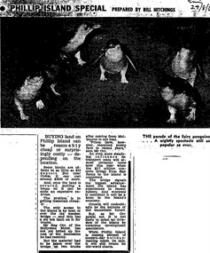
Work on paper - Photocopy of newspaper cutting, Melbourne Sun newspaper, "PHILLIP ISLAND SPECIAL PREPARED BY BILL HITCHINGS", 29.08.1969
This article by journalist Bill Hitchings describes the state of the land market and cost of transporting building materials, Phillip Island, late 1960s. At that stage a number of outlying residential estates had been created, especially on Phillip Island South Coast and at Cowes West. While blocks of land on the outlier estates were very cheap and poorly serviced, the Cowes blocks were selling at $3000 per residential block. Hitchings quotes the owner of the Hollydene motel, Reg Orr, as saying that when the new bridge opens shortly he did not expect it to create a rush of visitors or residents.Bill Hitching was a well-known Melbourne journalist. This article gives an idea of land values on Phillip Island in the late 1960s, the fact that business owners were prepared to upgrade and expand their businesses to cater for extra potential demand on accommodation, and the strong identification of Phillip Island with the Phillip Island Penguin Parade in the minds of the general public in Melbourne. The significance of the new Phillip Island bridge to Phillip Islanders and visitors, and the cost of the bridge, are also outlined. Reg Orr was highly active in the business community of that era on Phillip Island. The Hollydene motel was a well-known Phillip Island accommodation venue.T-shaped article cutting with large image at top of article, dark due to poor photcopy. Double collumn text under photo clearly readable. Black and white.Sun/29/8/6 (?) Probably: Melbourne Sun newspaper, 29 August, 1969phillip island, phillip island tourism, development, hollydene motel, reg orr, phillip island penguin parade, land values, phillip island first bridge, phillip island 2nd bridge, transportation costs -
 Wodonga & District Historical Society Inc
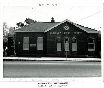
Photograph - Codling Collection 01 - Wodonga Post Office
Miss Olive Codling was a Foundation Member and a Life Member of the Wodonga Historical Society. Many of her photos are held in the Society Collection. The Wodonga Post Office was constructed on the corner of Sydney Road (High Street) and South Street in 1874. It was Wodonga’s second Post Office. The original post office opened on June 1, 1856 near Wodonga Creek. This building was originally built of red brick, although it was later painted over in white. It had an attached residence in South Street and was connected to it by a door. The residence was later demolished to move the mail boxes which had faced High Street, to South Street. The brick Telephone Exchange was constructed in 1946 behind the Post Office but separated from it. It operated as a manual exchange until the late 1960’s or early 1970’s. In 1985 a new post office was opened further south in High Street. This building, greatly renovated, is now part of the Wodonga Community College.This photo collection is significant as it documents how the businesses and buildings in Wodonga have evolved and contributed to community throughout the 20th century. A black and white image of the 2nd Wodonga Post Office. There are 6 windows across the front of the building and the name Wodonga Post Office below a round clock. To the left of the building is the royal insignia of the crown above the letters E.R. A sign for the Commonwealth Saving Bank of Australia is also attached to the wall.high st wodonga, wodonga post office, businesses wodonga -
 Wodonga & District Historical Society Inc
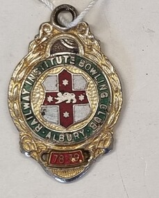
Badge - Railway Institute Bowling Club Albury 1978 - 79
The New South Wales Railway Institute affectionately known as “the Institute”, was initially established to provide a higher standard of educational learning for NSW railway employees. As well as employment related training, the Institute was tasked with stimulating growth and intellectual development of employees in the arts, social, leisure, and physical recreations. The NSW Railway Institute was formally opened on the 14th of March 1891 and at the time was the only institution of its kind in the Commonwealth. The Albury branch of the Railways Institute was formed on March 1, 1921. This included the building of a Railway Institute building as part of the Railway precinct in 1921. On Tuesday 7 October 1952, the Daily Advertiser, Wagga reported that a move had started at Albury for the establishment of a third bowling club. The new club formed would be the Railway Institute Bowling Club and the suggested site was on Albury City Council land at the corner of Young and Smollett streets. The Albury Railway Institute opened its bowling greens in February 1956. It later became known as Windsor Park Bowling Club. In 2003, the Bowling Club was liquidated and was amalgamated with the Albury Soldiers Sailors & Airmen’s Club. After changes to their operating model, the club building was demolished in 2013. This badge is representative of the role played by the NSW Railway Institute for its members and its involvement in the broader community.Member's badge for the Railway Institute Bowling Club Albury. A small metal badge with enamel finish depicting the logo of the club in green, red, gold and white.Around the central logo "RAILWAY INSTITUTE BOWLING CLUB ALBURY/ 78-79"railway institute, bowling clubs, social activities albury -
 Wodonga & District Historical Society Inc
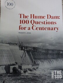
Book - The Hume Dam: 100 Questions for a Centenary, Howard C Jones, 2019
A booklet describing the history of the Hume Dam in question-and-answer format, illustrated by photographs from the Albury City Collection and other sources. This booklet was produced to accompany the exhibition "Turning the sod: building the Hume Dam", on display at Lavington Library from 21 December 2019 -1 March 2020."non-fictionA booklet describing the history of the Hume Dam in question-and-answer format, illustrated by photographs from the Albury City Collection and other sources. This booklet was produced to accompany the exhibition "Turning the sod: building the Hume Dam", on display at Lavington Library from 21 December 2019 -1 March 2020." hume dam, dams -- new south wales, hume dam history, dams -- new south wales -- design and construction -
 Wodonga & District Historical Society Inc
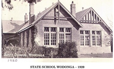
Photograph - First State School in Wodonga, 1920
Wodonga township’s first school was conducted in a small rented wooden cottage from September 1857. It was called the Belvoir National School. The building of a new schoolhouse, No. 378, began in October the same year near the corner of High and South Streets. In 1872 it changed to No. 37 Wodonga. The name was changed to Wodonga State School in 1875. This name remained until which remained until 1938 when it became a Higher Elementary School. In 1951 the Victorian Education Department purchased 12 acres of land in Ariel Street for the purpose of re-siting the State School. At this stage there were 600 pupils attending the school of which 170 were in the secondary section. Initially the Infant department moved into pre-fabricated classroom on the new site and by 1954 the whole primary school had been transferred.. The building was used became the temporary home of the Wodonga High School and later the Wodonga Technical School until they moved to new premisesA black and white image of school building mounted on card.At bottom of image: "WODONGA STATE SCHOOL 1920"wodonga state school, education wodonga -
 Wodonga & District Historical Society Inc
Mixed media - John Kenneth Darnton Watson and de Kerilleau Homestead
de Kerilleau was built for William Huon, son of the early pastoralist Paul Huon, in 1870 and named after the family's ancestral estate in France. The original lease of the Wodonga Run was granted to Paul Huon as No. 202 on 7th February 1837, about a year after his cousin Charles Huon had squatted on the land. Kenneth Darnton Watson bought de Kerilleau homestead in 1922 where the Watson family lived for three generations, caring for the land and serving the Wodonga community. Kenneth, his son Ian Darnton Watson and his grandson John Kenneth Darnton Watson all served on the Wodonga Council. The magnificent two storey brick homestead is built on ground above Wodonga Creek. The home of Georgian style consists of eleven rooms and a spacious cellar. At the rear of the main house in a separate single storey building was a large kitchen, pantry and accommodation for a cook and a housemaid. A feature of the homestead is the cast iron lace on the veranda and upper balcony, both supported by caste - iron pillars. The granite foundations of the home were quarried from the hill above the homestead. The enormous Moreton Bay Fig tree which stands to the side of the home was planted when Sir Charles Bowen visited de Kerilleau to mark the opening of the rail line that connects Victoria with New South Wales. Planted in 1873, it is still standing today. This painting was donated to the Wodonga Historical Society by George, Digby & Dugald Watson on behalf of the late John & Chris Watson. John Kenneth Darnton Watson was born on 28 August 1960 in Wodonga. After completing his primary schooling locally, he boarded at Geelong College from 1973. John joined the rowing crews, starting in the 8th VIII crew and reaching the 1st VIII crew in 1978. He received multiple House colours awards for cross country, athletics and rowing and received School colours for rowing. On completion of his schooling, John spent some time jackarooing before studying farm management at Marcus Oldham College in Geelong, Victoria. He then returned home to de Kerilleau, Wodonga to manage the family property. In 1984 John married Christine Honybun, daughter of David Lewis Honybun and Marian Josephine Edkins. John and Christine had three sons. John was community minded and involved in a number of local organisations such as Apex and agricultural societies. He was elected to Wodonga City Council in 1997, serving until 2004. Due to increased pressure on available land to cater for the growth of Wodonga, some of the property was sold and in 2003 John donated 200 ha of Huon Hill ‘s western slopes to the City of Wodonga. After this time, he moved away from farming to become a Hungry Jack's franchisee. In 2009, the hard decision was made to sell de Kerilleau and John and his family moved into Wodonga. After sadly losing Christine to cancer in 2017, John became a member and Deputy Chairperson of the Albury Wodonga Regional Cancer Centre Trust Fund Board and Ambassador for the Sunshine Walk. Tragically after his own cancer battle, John Kenneth Darnton Watson passed away on 24 August 2023, aged 62 years following a life of service to the Wodonga community.This item is significant because it was owned by a prominent Wodonga family and came from a Historic Homestead in WodongaA coloured portrait of John Kenneth Darnton Watson and a painting of de Kerilleau Homestead, the Watson Family home for three generations. The portrait was taken by Peter Charlesworth. The painting is the work of D.K. Ross in 1991.watson family wodonga, de kerilleau homestead, john watson, peter charlesworth -
 Wodonga & District Historical Society Inc
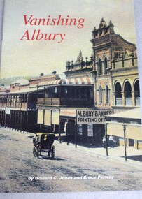
Book - Vanishing Albury: Heritage Buildings Lost and Reclaimed, Howard C Jones et al, 2000
A study of the development of Albury, New South Wales through its historic buildings.non-fictionA study of the development of Albury, New South Wales through its historic buildings.historic buildings, albury, albury - pictorial works -
 Ballarat Tramway Museum
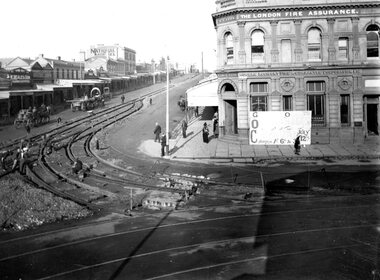
Photograph - Geelong Tramway new tracks for the South line
Tram tracks being laid for the South line up the Moorabo9ol St., hill and to connect with the already completed Ryrie St. tracks. Photo looks south. The date on the Orphanage carnival notice in front of the London Fire Assurance building (that still stands) is July 1911.Black and white print on paper.GRS710/24/1/4 and 24-4 written on the reverse in pencil. The No. 1 inside a circle x 2, and Orphanage Carnival are written on the reverse in ink.geelong tramway new tracks, geelong tramway south line -
 Ballarat Tramway Museum
Photograph - Geelong Tramways new tracks on South line
Tram tracks being laid for the South line up the Moorabool St., hill across the intersection of Ryrie St. Photo looks to the SE, curves in the foreground are the completed tracks into Ryrie St., heading towards the West and Newtown termini. The large building at left is the Geelong Theatre.Black and white print on paper.The no., 1 inside a circle written in ink on the reverse. GRS710/25/1/3 and 25-3, written in pencil on the reverse.geelong tramway- new tracks, geelong theatre -
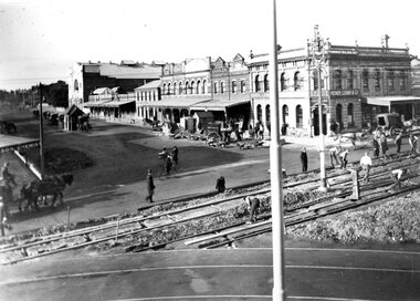
 Linton and District Historical Society Inc
Photograph, Hornsby Studio, Clunes, Bank of New South Wales and Post Office in Sussex Street, Linton, early 1900s
Dated "early 1900s", as the newer Bank of New South Wales (built 1903-1904) can be seen in the photograph.Black and white postcard photograph of two buildings in Sussex Street, Linton, brick building is Bank of NSW, wooden building is Linton Post Office. People standing in front, including one on a horse and one with a bicycle.linton post office, buildings, horses, bicycles, bank of new south wales -
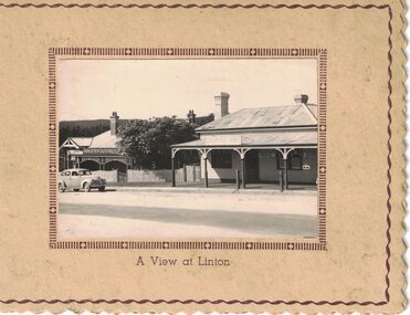 Linton and District Historical Society Inc
Card/Photograph, Christmas greeting card : A View at Linton, 1941, 1941
Sent as a Christmas card by T. & G. Thornton in 1941.A very small photograph which has been made into a plain, beige-coloured card with cut decorative edge and printed borders around edge of card and edge of photograph. The photograph shows Linton Post Office and Bank of New South Wales. A car (1940s or 1950s Holden?) is parked in Sussex Street outside the bank building. The words "A View at Linton" are printed on the front of the card underneath the photograph. A paper insert in the card has printed on one half: "May all the joys of an old-time Christmas be yours, and may the New Year be a happy one". Part of the other half of the paper insert has been cut away, but on the part that remains is the inscription: "from Tom & G. Thornton / Xmas 1941".On paper insert: "From Tom and G Thornton-Xmas 1941".tom thornton, g. thornton, linton post office, bank of new south wales linton, greeting cards, christmas cards -
 Charlton Golden Grains Museum Inc
Photograph, High St Charlton c. 1988, c.1988
Bilton/Dillon building c. 1988 occupied by the Charlton Pharmacy managed by R. English, H. Hargreaves Gift Shop and the Mallee Kitchen. Series of photos taken of High Street after new footpaths and kerbing were put down in 1987-88.Colour photograph of High St Charlton looking east. Photo taken high on the south side looking across to Bilton/Dillon building. Other buildings on the east side of HIgh St include Westpac Bank, Globe Hotel, The Charlton Club, East Charlton Hotel. On the south side is the awning for the Charlton Cinema. Bunting is stretched across the street.bilton building, dillon building, english chemist, hargreaves gift shop, mallee kitchen -
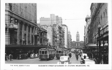 Melbourne Tram Museum
Postcard, Rose Stereograph Co, "Elizabeth Street & Flinders St Station, Melbourne", 1940s
Rose Series postcard No. P 4016 titled "Elizabeth Street & Flinders St Station, Melbourne", showing W5 class trams 742 and 737, both on route 18 in Elizabeth St looking south from Bourke Street. It is a very busy and congested scene with motor and horse-drawn trucks, cars, cyclist and pedestrians. Note the man in a peaked cap in the bottom right-hand corner - a Chauffeur? There is advertisement for "War Saving Certificates" on the balcony of London Stores. Other retailers in Elizabeth Street are Brash's music and Wittner Shoes. The new Royal Bank building is visible on the corner south east corner of Collins Street. Yields information about a busy scene in Elizabeth Street Melbourne in the 1940's .Postcard - printed real photograph with Rose Stereograph Co. name on the rear. Two copies held.Second copy has the K. J Magor stamp on the rear.tramways, trams, elizabeth st, tram 742, tram 737, w5 class, world war ii, route 18 -
 Victorian Railway History Library
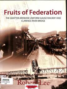
Book, Lee, Robert, Fruits of Federation, 2009
A history of the railway from Grafton to Brisbane and the building of the rail/road bridge over the Clarence River at Grafton.index, ill, maps, p.166.non-fictionA history of the railway from Grafton to Brisbane and the building of the rail/road bridge over the Clarence River at Grafton.railroad construction - new south wales - history, railroad operations - new south wales - history -
 Federation University Historical Collection
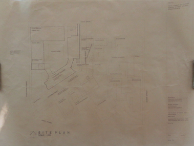
Plan, Ballarat School of Mines Schematic Proposal for the Former Ballarat Brewery Site
The Project Manager for the Ballarat School of Mines Brewery Building was Peter Davies. The plan suggests the closure of Lydiard Street South Copy of the Site plan for the Ballarat School of Mines Brewery Building, built on the site of the former Ballarat Brewery. The plan shows where the new building sites in relation to all other buildings at the Ballarat School of Mines ballarat school of mines, brewery building, ballarat brewery, architectural plans, schematic proposal, smb campus, former ballarat gaol, chimney tower, m.b. john building, lydiard street south, armstrong street south -
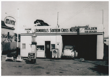 Linton and District Historical Society Inc
Photograph, Dumbrell's Southern Cross Motors, 52 Sussex Street, Linton
This garage was on the site of the Ball family's blacksmith's workshop. In 2017 parts of the building are still on the site, although in a very dilapidated condition.Photograph copied from original of a petrol station/mechanic's workshop. At the time the photograph was taken the workshop was owned by John and Alice (Jill) Dumbrell. The date the photograph was taken is unknown. The car that is parked in the workshop was owned by Ernie Page, an employee of the Bank of New South Wales in Linton.john dumbrell, alice (jill) dumbrell, dumbrell's southern cross motors linton, holden dealership linton, atlantic petrol, buildings, petrol stations, mechanics, dark family -
 Bendigo Military Museum
Photograph - 4 Fd Svy Sqn Closure Ceremony 25 Nov 1995, 4 Fd Svy Sqn, Keswick Barracks, Adelaide, 25.11.1995
Between 1915 and 1951, military topographical mapping in SA was conducted by Royal Australian Survey Corps (RASvy) units based outside the state. In February 1952, Army HQ Field Survey Section (Central Command Detachment) was established in Adelaide in a drill hall at Largs Bay. It was tasked with providing map coverage in the Woomera and Southern areas of the state. The section was subsequently reorganised as Central Command Field Survey Section moving firstly to Hampstead Barracks, Hampstead in 1953 and then into accommodation at Keswick Barracks in 1954. In 1957 the Section commenced mapping operations in the NT. The Unit was relocated to the old cavalry stables in 1961 and was redesignated Central Command Survey Unit and remained there till 1973. In 1970 the Unit was redesignated 4 Fd Svy Sqn and engaged in operations conducted in PNG from 1972 to 1974 inclusive. In 1973 the Squadron moved into a brand new two-storey specially designed and purpose built building adjacent to the old building. The old building then became the Squadron Q and Map store with an interconnecting lobby to the new building. Since 1975 the Unit was involved in the 1:50,000 Mapping Programme in WA, NT, QLD, SA and conducted many other operations within Australia and overseas. Post disbandment of the Corps the old Squadron building (cavalry stables) now houses the Army Museum of South Australia (AMOSA). The Royal Australian Survey Corps was amalgimated into the Royal Australian Engineer Corps in July 1996. In the lead up to this amalgamation, 4 Field Survey Squadron Keswick Barracks, Adelaide, South Australia was disbanded in 1995. A closing Ceremony was held on 25 November 1995 at 4 Fd Svy Sqn Keswick Barracks attended by about 208 former members of the Unit. A photo was taken of attendees at that event on the day and a list was prepared of attendees. All attendees were sent a copy of the photograph and the list of names as a momento of the Unit and the ceremony..1P A4 Print of an original photo of attendees at the 4 Fd Survey Sqn Closure Ceremony at Keswick Barracks 25 Nov 1995. .2P A4 Print of the names of the attendees at the 4 Fd Survey Sqn Closure Ceremony at Keswick Barracks 25 Nov 1995. Approx 208 attendees.royal australian survey corps, rasvy, fortuna, army survey regiment, army svy regt, asr, 4 fd svy sqn -
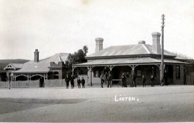
 Linton and District Historical Society Inc
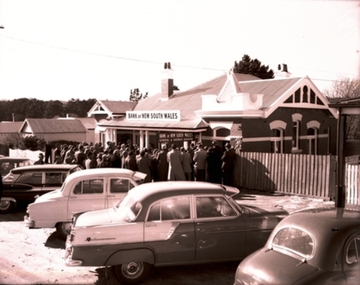
Photograph, Centenary of the Bank of New South Wales in Linton, 1960
The original photograph is in the archives of the Westpac Bank in Melbourne. A digital copy was sent to LDHS by John Young in 2018.Black and white photograph taken at the centenary celebrations for the Bank of New South Wales, Linton, held on 14 June 1960. The photograph shows several cars parked in Sussex Street outside the bank building (the second bank building, built in 1904), and a group of people gathered at the front entrance to the building.bank of new south wales. linton branch, centenaries -
 Linton and District Historical Society Inc
Photograph, Annie Lewers
Born in Ireland in 1838, Annie Ross married Samuel Lewers at Creswick in 1856. Samuel Lewers, a gold buyer and bank agent, became manager of the Bank of New South Wales in Linton in about 1860, and was afterwards the first Shire of Grenville President and a Justice of the Peace. Annie and Samuel Lewers had eleven children. They lived in the residence at the Bank of NSW building in Sussex Street (this building now known as Traquair House). Around the time Samuel Lewers retired in 1895 they leased and moved to Emu Hill, the property formerly owned by the Linton family, at that time owned by Edward Morey. Samuel Lewers died shortly after his retirement, in 1895. Annie Lewers died at Emu Hill in 1904.Black & white copy of original photograph, showing Annie Lewers as a comparatively young woman. She is shown wearing an elaborate dress with white collar and cuffs. Studio portrait, subject is standing with right hand resting on the back of a chair. (Mrs. Samuel Lewers)annie lewers, mrs samuel lewers -
 Mission to Seafarers Victoria
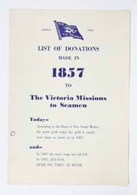
Pamphlet, List of Donations made in 1857 to the Victoria Missions to Seamen, 1957
The inside pages of this pamphlet list the many donors and subscribers who initially supported the Victorian Mission to Seamen whose first chapel was based on a floating Hulk named the Emily. The most generous 1857 donors at 20 guineas Dove and Oswald, ship owners, (also the name of the Heritage floating dock at Williamstown). The point of this pamphlet published in 1957 appears to be a reminder of longstanding support and as part of an appeal to new donors to assist with increased costs. It also compairs the donations betwwen 1857, 50 years later in 1907, and in 1957 the year of Centenary. It may well have been designed to hand out at screening of the short documentary produced by Cinesound circa 1956/57 and 'starring' Padre Oliver visiting ships and footage of the Mission interiors at both 717 Flinders st and the Deco 1936 building at Port Melbourne.The listing of donors is of some historical significance showing the range and names and is a useful reference for further research re significant figures of Melbourne and Victoria in the original establishment of the Mission by the Bethel Union.single fold paper pamphlet with blue printed text with flag of the Missions to Seamen at top of page.List of Donations / made in 1857 to the / Victoria Missions / to Seamen / Today - According to the bank of New South Wales / the price paid today for gold is nearly four times as much as in 1857. / and- / In 1907 the basic wage was 2 pounds 2/- ( 2 Guineas) / In 1957, 12 - 15 pounds/ Over six times as much. Inside the pamphlet alphabetical list of donorsdonor names, 1857, centenary, fundraising, mission to seafarers, seamen's mission, donations, 1957, 1907, currency conversion -
 Bendigo Historical Society Inc.
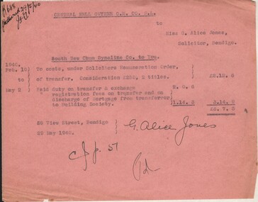
Document - MISS G ALICE JONES COLLECTION: ACCOUNT
Central Nell Gwynne G. M. Co. N. L. to Miss G. Alice Jones. Pink paper dated Feb.10 to May 1940 and 29 May 1940. Re South New Chum Syncline to You. Account details costs of transfer, and discharge of Mortgage from transferor to Building Society. "R688 delivered 29/5/40" written in top left corner.miss g. alice jones collection - account, central nell gwynne g m co n l, south new chum syncline co -
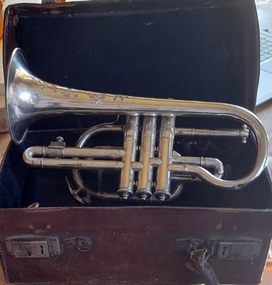 Hymettus Cottage & Garden Ballarat
Instrument - Cornet, Boosey Cornet
In 1920 Michael Taffe was awarded Junior Cornet Solo Champion at Ballarat's South St competitions, The Grand National Eisteddfod of Australasia. This competition was the premier band contest in Australia with musicians from every state and New Zealand taking part. This Boosey & Co cornet was on display in the window of Allan's Music store Melbourne when the building was severely damaged by fire but these items were saved. Part of a large family collection of local & family history items at Hymettus Cottage, home to the same Ballarat family for the past 125. This cornet has a well documented provenance and a known owner and has been at Hymettus for over a century. Boosey & Co joined with Hawkes in 1930 to become Boosey & Hawkes. This cornet forms part of a significant and representative historical collection that reflects Ballarat's local history from a family perspective. It contributes to our understanding of social and family life in Ballarat from the 19th to the 21st century and provides interpretative capacity for family, local, and social history themes.Heavily decorated and inscribed.cornet, music, michael taffe, south street competitions, ballarat, boosey & co -
 Eltham District Historical Society Inc
Photograph - Digital Photograph, Marguerite Marshall, Jelbart home, 93 Arthur Street, Eltham, 11 November 2006
Situated at the top of the hill in Arthur Street, the former Jelbart residence and barn were part of a major change that transformed Eltham's character in the late 1960s. Built from the mid 1940s through mid 1950s when Eltham was a rural community, the Jelbrat residence and barn are all that remain of a family property of some 250 acres (100 ha). With growing population pressures, in the late 1960s, owners Ron and Yvonne Jelbart decided to subdivide their property creating the Woodridge Estate in the early 1970s, a major factor towards the transformation of Eltham to the suburb it is today. The Jelbarts had moved to Eltham in the early 1940s when they purchased a poultry farm in New Street, now Lavendar Park Road. (The local Black Friday bushire of January 13, 1939 had started at C.A. (Clarrie) Hurst’s Eltham Poultry Farm and Hatchery in New Street.) Jelbart was primarily a businessman importing office machinery but desired farm beef and dairy cattle so the couple purchased the virgin bushland at what was then at the end of a dirt road, Arthur Street. With post war shortages of most building materials, they followed the example of the Eltham Artists' Colony (later called Montsalvat) and built thier home from mud-bricks and recyclked materials. The barn was first to be completed in 1945 which they made their home whilst building the main residence. It took eight years to complete the two buildings. Both the main residence and the barn are now separate homes, and along with the remaining property being sub-divided further in 1998 are now part of the Kinloch Gardens Estate at 93 Arthur Street. Covered under Heritage Overlay, Nillumbik Planning Scheme. Published: Nillumbik Now and Then / Marguerite Marshall 2008; photographs Alan King with Marguerite Marshall.; p139 Standing on a hilltop at Arthur Street, Eltham, the Jelbart residence and former barn were part of a major change that transformed Eltham’s character in the late 1960s. Built from the late 1940s to the mid 1950s when Eltham was a rural community, they are all that remain of what was once a family property of around 250 acres (100 ha). As population pressure increased in the late 1960s, owners Ron and Yvonne Jelbart, decided to subdivide their property. The break-up of this property into the Woodridge Estate in the early 1970s, was a major factor towards transforming Eltham into the suburb it is today.1 Although standing only a few minutes from Eltham’s busy hub and hundreds of houses in Woodridge, scarcely any urban sound disturbs the peace. Views from the two buildings are almost exclusively of trees and extend to Mt. Dandenong to the south-east, the Great Divide to the north, and Melbourne city to the south-west. The Jelbarts had lived in Eltham since the early 1940s when they bought a poultry farm in New Street, now Lavender Park Road. Although Jelbart was primarily a businessman importing office machinery, he was keen to farm dairy and beef cattle, so the couple bought rough bushland at what was then the end of Arthur Street. But a shortage of building materials following World War Two hampered their plans to build their new home, so they followed the example of the Eltham Artists’ Colony (later called Montsalvat) and used mud-bricks and recycled materials.2 With great determination the family and friends constructed their house. Massive timber frames and huge quantities of mud-bricks were made on site. The barn was built first in 1945, and two years later, while camping inside, the Jelbarts started building their house. It took eight years to construct the two buildings, even with the help of professional tradesmen. The buildings, with timber frames infilled with mud-brick and plastered, are reminiscent of the English Tudor style. The Jelbarts are of Cornish stock. Much of the timber framework came from demolished bridges or warehouses, and recycled slate was used for roofs and floors. Quality second-hand materials were readily available in the late 1940s and 1950s when there was much demolition in Melbourne and little respect for heritage. A former 19th century Toorak mansion Woorigoleen provided the magnificent stone fireplace, the timber panelling and the parquetry floor in the living room. The large stone gateposts at the entry of the property came from Melbourne University. Almost no mechanical equipment was used to build the 55 square house and the 25 square barn. Massive timber frames were erected using block and tackle pulleys and timbers were shaped, sawn and drilled by hand. Son and architect Ian, with his family, have lived in and extensively renovated both buildings since the early 1970s. Ian transformed the steep ridge of the property into a plateau, where the main house Kinloch stands, surrounded by terraces and lawns. The grounds retain many native plants, including massive yellow boxes – some nudging 80 years. Ian attached 70 metres of pergolas draped with wisteria, roses and grape vines, to three sides of the house. The beautiful garden is featured in the book Through the Rose Arbour by Rosemary Houseman. The two-storey barn – now a house – retains traces of its original use. The cow-shed with milking and feed-rooms, and the machinery-shed remain. The house, separated on the ground floor by a breeze-way, soars two storeys and includes a mezzanine. These are connected by spiral staircases, to timber-beamed and plaster-lined high-pitched ceilings. The house also descends to a wine cellar. Curiously the roof is of corrugated iron on the south and slate on the north, to save costs. Small-paned windows and three French doors open onto the front lawn, which extends to Jelbart Court.This collection of almost 130 photos about places and people within the Shire of Nillumbik, an urban and rural municipality in Melbourne's north, contributes to an understanding of the history of the Shire. Published in 2008 immediately prior to the Black Saturday bushfires of February 7, 2009, it documents sites that were impacted, and in some cases destroyed by the fires. It includes photographs taken especially for the publication, creating a unique time capsule representing the Shire in the early 21st century. It remains the most recent comprehenesive publication devoted to the Shire's history connecting local residents to the past. nillumbik now and then (marshall-king) collection, eltham, arthur street, jelbart barn, jelbart home, kinloch gardens -
 Eltham District Historical Society Inc
Photograph - Digital Photograph, Alan King, Original Kangaroo Ground Primary School No. 2105 building, Eltham-Yarra Glen Road, Kangaroo Ground, 28 December 2007
Kangaroo Ground's first school began in 1851 with 22 pupils from the district's ten families. It was a single room school located further south on the site, which also served as a Presbyterian church. The first teacher was Andrew Ross. The school building was used as a Post Office between 1854 and 1858 and during 1857 also served as a Court of Petty Sessions. With a growing farming community, a new building was warranted and the original Sate School No. 352 was closed and a new building, State School No. 2105 was oipened October 1, 1878. A residence for Head Teacher Henry Wallace School was erected in 1879 attached to the left of the school building. That residence is now home to the Andrew Ross Museum, which opened in 1993. Covered under Heritage Overlay, Nillumbik Planning Scheme. Published: Nillumbik Now and Then / Marguerite Marshall 2008; photographs Alan King with Marguerite Marshall.; p35 In a corner of the Kangaroo Ground Primary School playground stands an old weatherboard building. This structure, attached to the former teacher’s weatherboard residence facing Main Road, first served as a school in 1878. The former residence, built in 1879, houses the Andrew Ross Museum, which opened in 1993. It is named after the school’s first teacher,1 who also founded The Evelyn Observer newspaper, which began on the site in 1873. Later the printing presses were moved to brick newspaper offices by the Kangaroo Ground Hotel, which became the Shire of Eltham offices. However Kangaroo Ground’s first school began in 1851 for 22 pupils from the district’s ten families, in a slab building further south on this site. Andrew Harkness and other settlers campaigned for the building, which was built on half an acre (0.2ha) donated by local farmer, James Donaldson. Builder was Samuel Furphy, father of the novelist Joseph.2 The single room measuring 30 feet x 18 feet (9m x 5.5m), was unlined and the green slabs shrank, allowing the wind and rain entry through cracks except when they were stuffed with paper.3 The building served as a Presbyterian church as well as a school, where fees were 18 pence a week for education. Young men also attended evening classes there in winter. At one stage, a corner of the room was curtained off for the schoolmaster’s living space, and the platform, which was used for sleeping, was also the pulpit during church services. Teacher Andrew Ross also took church services when the minister was unable to attend, which happened frequently as he had long distances to travel on the bad roads. In 1857 the school building was also used as the Court of Petty Sessions, and from 1854 until 1858, it served as a post office. During the gold rush fossickers on their way to the Caledonia Diggings at Queenstown (now St Andrews) prospected the district, but did not remain long, as the fields were not rich in gold. But the farming community grew, until by 1878 the population warranted the building of State School No 2105 – the present one-roomed tongue-and-groove lined building measuring 49 feet x 18 feet (15m x 5.5m), to accommodate 60 children. The old school, No 352, was closed, and the new one opened on October 1, with Henry Wallace as head teacher, assisted by work mistress Annie Johnston. Early teachers included Messrs Smith, Hamilton and Prosser, with sewing teachers Misses Sweeney, Limerock and Oliver. In the early 1920s a small room was built on the front veranda of the teacher’s residence, and used as a State Savings Bank agency until about 1934. In 1928 the schoolroom’s three-tiered floor was replaced by a flat floor and teacher’s platform (which has since been removed). A half-glassed partition wall then divided the large room into two rooms in which the old style form-type desks were replaced with dual desks. The small playground, surrounded by pine trees and a picket fence, was extended in 1931 with an additional acre or so (0.4 ha) of land. During World War Two the school faced closure because of a fall to seven in the enrolment, but by 1946 it had increased again to 45. Mr Eric Morgan was head teacher and Mrs Margaret Banks was assistant head teacher, a position she held for ten years. In 1955, under the head teacher Mr V Gardiner, who taught there for 13 years, the school won a prize for the best-kept garden and school ground in the inspectorate. A district subdivision increased the enrolment in 1968 to 65 and a bus service was established. After the hall which had been used for lessons was demolished late that year, the pupils met in the original fire brigade meeting room (now the tennis club, diagonally opposite the general store). The new school building with a storeroom and staffroom was built in 1974.This collection of almost 130 photos about places and people within the Shire of Nillumbik, an urban and rural municipality in Melbourne's north, contributes to an understanding of the history of the Shire. Published in 2008 immediately prior to the Black Saturday bushfires of February 7, 2009, it documents sites that were impacted, and in some cases destroyed by the fires. It includes photographs taken especially for the publication, creating a unique time capsule representing the Shire in the early 21st century. It remains the most recent comprehenesive publication devoted to the Shire's history connecting local residents to the past. nillumbik now and then (marshall-king) collection, kangaroo ground, andrew ross museum, eltham-yarra glen road, kangaroo ground primary school no. 2105, kangaroo ground state school, state school no. 2105